A report published in the April 7 edition of Satellite Navigation (DOI: 10.1186/s43020-025-00162-z) concludes that hybrid approaches are the most reliable solution for UAV navigation. The comprehensive review, by a research team from Prince Sultan University, evaluated 132 papers on UAV navigation in GPS-denied environments.
The research team focused on absolute and relative localization techniques including vision-based systems, lidar and terrain-aided algorithms. The review examined two primary methods for UAV navigation in GPS-denied areas:
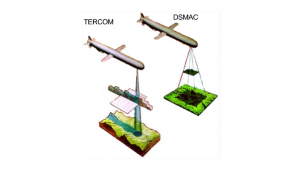
absolute localization, which uses pre-mapped terrain data (such as TERCOM and DSMAC)
relative localization methods such as SLAM (simultaneous localization and mapping) and visual-inertial odometry that relies on real-time sensor data.
While absolute methods face limitations in featureless environments, relative techniques offer adaptability but require significant computational resources. Vision-based systems, particularly when enhanced with AI for feature recognition, hold considerable promise, though lighting conditions remain a challenge, the report concludes.
The research emphasizes the importance of sensor fusion, demonstrating that combining lidar, radar and inertial measurements – alongside advanced filtering techniques such as Kalman filters – can substantially improve navigation reliability.
Furthermore, real-time processing is crucial, with hardware accelerators like GPUs and optimized algorithms, such as LSTM networks, enabling faster data analysis and decision-making.
While hybrid systems combining terrain maps with live SLAM data offer a balance of accuracy and flexibility, the study acknowledges the need for further refinement to scale these solutions across various environments. Advancements in AI processing power and edge computing will be key to fully autonomous UAV operations in unpredictable real-world conditions.
“No single sensor or algorithm can solve all the challenges of GPS-denied navigation,” said Imen Jarraya, lead author of the study. “Our research shows that combining absolute and relative localization with multi-sensor fusion is the key to achieving reliable UAV navigation. Future work must focus on optimizing these systems to handle the unpredictability of environments ranging from dense urban areas to remote disaster zones.”
This research holds implications for industries relying on UAVs, such as logistics, agriculture, and defense, Jarraya explained. UAVs delivering medical supplies to remote or disaster-stricken areas could operate without GPS, and military drones could navigate in signal-jammed regions.
The study also points to the need for regulatory frameworks to standardize these technologies, ensuring their safe and efficient integration into future infrastructures. As UAVs become integral to smart cities and infrastructure inspection, overcoming the limitations of GPS will ensure safer, more effective operations. These findings encourage further investment in AI-driven navigation and collaborative research to refine these systems for global use.
The European Union Agency for Space Programme (EUSPA) has released its first GNSS and secure satellite communications (SATCOM) user technology report, offering an overview of recent developments in GNSS and SATCOM. This publication combines and expands upon previous GNSS user technology and secure SATCOM market and user technology reports, offering a comprehensive look at current trends and advancements in user technology.
The report examines the satellite industry’s ongoing transformation, influenced by evolving security concerns, increased digitalization efforts, rapid progress in artificial intelligence (AI) and the emergence of the New Space sector. By addressing these topics, the report aims to provide stakeholders with up-to-date information on the state of satellite-based technologies.
Focusing on both GNSS and Secure SATCOM, the publication explores recent innovations in user technology, such as terminals and receivers. It also investigates potential synergies between these two fields. This approach allows readers to gain insights into how these technologies are developing in parallel and potentially converging in certain applications.
Developments and trends in GNSS technology
The report opens with a summary of the recent developments and future trends in GNSS technology that are relevant to end users. As new GNSS frequencies and signals become available for civilian applications, receiver manufacturers have been upgrading their products to accommodate satellites in medium-Earth orbit (MEO). The international coordination among GNSS supports this advancement, Radio Navigation Satellite Service, and Satellite-Based Augmentation System providers, resulting in the adoption of open access signals with compatible frequency plans, common multiple access schemes and modulation schemes.
The report states that a service-oriented approach to GNSS is emerging, building upon existing infrastructure to offer users enhanced performance and security. The European GNSS program has made significant strides in this area, backed by the recent implementation of the Galileo High Accuracy Service (HAS) and Open Service Navigation Message Authentication (OSNMA) feature. The Report gives insight into emerging technologies and upcoming innovations, focusing on key trends in receiver electronics design and signal processing aimed at improving performance or reducing power consumption. Multi-frequency capabilities, PNT processing strategies and advances in antenna design are identified as key drivers shaping the future of GNSS receiver technology, according to EUSPA.
Among other topics selected, the spoofing and jamming threats are becoming a priority to be addressed both at the system and user level. Solutions such as Galileo OSNMA authentication and more resilient receivers with multiple antennas and sensor hybridization are being explored and are starting to be implemented.
Developing secure SATCOM systems
The secure SATCOM section of the Report outlines trends in the secure SATCOM domain by emphasizing enhanced performance and system management optimization. It specifically highlights how digitalization processes, cloud environments and AI techniques are enhancing performance and system management optimization in the secure SATCOM domain. It also notes the ongoing efforts to standardize the integration of non-terrestrial networks into the 5G ecosystem.
According to EUSPA, the deployment of large Non-Geostationary Orbit (NGSO) constellations aims to improve performance, particularly in reducing transmission latency. These systems rely on advanced user terminals capable of tracking and switching between multiple fast-moving satellites across the sky.
The report also emphasizes security in SATCOM transmissions, recognizing that satellite communications encounter similar threats from malicious signals as terrestrial communications. Consequently, both governmental and commercial SATCOM systems are being developed with a rising focus on enhancing the confidentiality, integrity, and availability of both governmental and commercial SATCOM systems links.
It also describes a shift in SATCOM systems from legacy hardware-centric designs to modern software-oriented solutions. This digital transition allows user terminals to utilize multiple constellations and frequencies, which significantly improves the availability of communication links. This can help mitigate disruptions caused by natural factors or intentional interference.
Exploring potential and existing synergies
The report concludes with an examination of existing synergies between GNSS, secure SATCOM, and Earth observation (EO). Notable examples include the transmission of EO data through SATCOM systems, utilizing GNSS for operating NGSO SATCOM terminals, the complementary use of GNSS and secure SATCOM in transport and emergency management, remote sensors used by Copernicus — a European EO program — that rely on both GNSS and SATCOM and high-accuracy GNSS positioning in remote areas enabled by SATCOM.
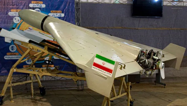
Iran is in the process of initial field testing of a new drone aircraft carrier — the Shahid Bagheri — a converted container ship.
Featuring an angled flight deck and ski-jump ramp, the ship seems well-equipped to launch large drones. Two additional drone-carrier vessels, the Shahid Mahdavi and Shahid Roudaki, have also been spotted during sea trials alongside this latest member of the Iranian Shahed drone-carrier fleet.
The objective seems to enable Iran to extend its drone attack capabilities across the Gulf, which is likely to concern Israel, the United States, and their allies. Nevertheless, the drone-carrier vessels do not appear to possess advanced defense systems, nor are they accompanied by destroyers or equivalent support. As such, they may be highly vulnerable to drone attacks.
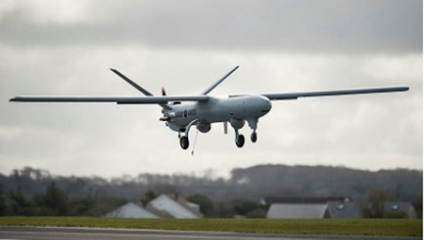
In 2004, the UK launched the Watchkeeper drone program, led by Thales UK and Elbit Systems through their joint venture, U-TacS. The program was contracted for £700 million ($852 million), with the first flight expected in 2006. It centered around the Elbit Hermes 450 drone with substantial modifications. The 2006 date slipped significantly as costs climbed through 2010, and authorization for military training only happened in 2014. However, the rollout for operational use was still delayed. During those initial tests, one in seven drones crashed in circumstances often associated with bad weather — not good for a drone designed and intended for all-weather operations. The trials were moved to locations with better weather conditions.
Initially featuring limited surveillance and target acquisition capabilities, the Watchkeeper WK450 drone has been enhanced with upgrades that include synthetic aperture radar and ground-moving target indication, in addition to its original electro-optical/infrared sensor.
Watchkeeper flight in April 2013. (Photo: UK MOD)
The drone was used for English Channel patrol and for some uncontested airspace surveillance and targeting missions in Afghanistan. It was most recently fielded in NATO exercises in Estonia, flying in different weather conditions to verify airspace deconfliction and interoperability with Estonian air traffic control.
Unfortunately, program delays, which have sometimes been associated with over 1000 additional UK requirements during the development cycle, difficulties in training, cost growth from the original £700 to an ultimate program cost of £1.35 billion ($1.64 billion), along with obsolescence brought on by the years of delays — these have all now doomed the Watchkeeper drone program to retirement, which the UK recently announced.
Watchkeeper drones were eventually priced at $5.2 million each for a quantity of 45 to 54, for a task which today’s drones, costing maybe $30 thousand, are much more capable. A fate also perhaps brought on by the fantastic rate of evolution for today’s commercial drones versus the well-trodden, somewhat lengthy path of mil-spec development programs.
The US Air Force has established an advanced technology test area at Eglin Air Force Base (AFB) — the Autonomy, Data and AI Experimentation Proving Ground. Near Earth Autonomy (NEA) recently worked with Eglin to demonstrate the capabilities of its Griff 135 multicopter drone and its autonomous avoidance capability.
NEA has developed avoidance and autonomous navigation capability, which allows its drones to fly beyond visual lines of sight by knowing their location with respect to the environment around them. With optical and electronic sensors, the drone builds a point-cloud image of its surroundings on a separate computer from that which manages its autonomous behavior. The two systems interact to provide autonomous flight, including obstacle avoidance, take-off and landing, and, in several cases, the delivery of special cargo, such as blood and medical samples.
In the case of the Eglin tests, the objective was for the Griff 135 to interact with a Service-Malory TRV-150 cargo drone operated by the 413th Flight Test Squadron. Now, we have a four-rotor cargo drone capable of carrying 150 lb of cargo and an eight-foot quadcopter capable of destroying each other in a potential collision. First, they are independent; one is manually operated, and the other has an autonomous capability. But who knows if it can see, detect, and avoid another fast-moving drone in the same airspace? So, the flight test had the two crossing paths to verify, detect, and avoid by NEA drone. Two flight sessions and the Griff-135 did a good job seeing, computing and executing multiple avoidance maneuvers.
NAE UAV. (Photo: NAE)
NAE was awarded a NASA Small Business Innovation Research grant for its autonomous aircraft inspection technology. Before a flight departs, one of the crew members inspects the aircraft, checking flight controls, lift surfaces, and tires for any damage or issues that could impact the upcoming flight or need maintenance later. Engineering personnel also conduct visual inspections, though perhaps not for every flight, to frequently verify the aircraft’s integrity.
NAE has collaborated with NASA and Boeing to create autonomous software that allows their drone to conduct a thorough visual inspection of aircraft. The FAA mandates an inspection card outlining the requirements and the specific path around the aircraft for inspections. NAE has integrated these requirements into its drone, resulting in an automated inspection process that captures a high volume of detailed photographs from every part of the aircraft. This automated system completes inspections in approximately 30 minutes, in contrast to manual inspections, which can take up to four hours. The system is reportedly progressing toward the commercialization stage.
The automotive navigation of tomorrow is highly connected and capable of dynamically using high-resolution map information and vehicle and environmental data from the cloud. It is an enabler for powerful driver assistance, intelligent e-mobility and autonomous driving. As a global provider of software engineering services for the mobility industry, Intellias is involved in many of these developments.
Although obtaining mapping and navigation data is easier today than it was 10 years ago — thanks to dashcams, UAVs and satellites — collecting this data is still labor-intensive. Even if most corners of the world are already recorded in public and private geographic information systems (GIS), the maps still need to be maintained regularly. Data accuracy and timeliness are the two biggest challenges in the mobility industry, followed by coverage, as the physical world is constantly evolving. To meet these requirements, the evolution of navigation and digital mapping is gathering pace. The following six technology and deployment trends will drive automotive mapping and navigation in the coming years.
1. Enriching Mapping Data With AI
Satellite imagery was a breakthrough for map creation. The wrinkle, however, is that most mapping software cannot work directly with satellite photos. Visual data first needs to be codified into comprehensive navigation datasets in a suitable format such as the Navigation Data Standard (NDS). Then map owners must keep it up to date. Both processes are costly and labor-intensive, making them great use cases for artificial intelligence (AI) in mapping.
AI algorithms improve the speed and precision of digital map building by offering the ability to update maps more regularly and map new areas faster. They can classify objects in satellite images — buildings, roads, vegetation — to create enriched 2D digital maps as well as multi-layer 3D map models. With precise maps, you can delight users with better ETAs, detailed fuel or energy usage estimates, and richer point-of-interest information.
Apart from facilitating the collection of mapping data, AI can also help with generating such data. Researchers from MIT and the Qatar Computing Research Institute (QCRI) recently released RoadTagger. This neural network can automatically predict the road type (residential or highway) and number of lanes even with visual obstructions present, such as a tree or building. The model was tested on occluded roads from digital maps of 20 U.S. cities. It correctly predicted the number of lanes with 77% accuracy and predicted road types with 93% accuracy.
That said, sensor data collection from connected vehicles isn’t going anywhere. OEMs are increasingly relying on their fleets to collect new insights for digital map creation, and this process is becoming easier with advances in machine learning. HERE Technologies recently presented UniMap — a new AI-driven technology for faster sensor data processing and map creation. The new solution can effectively extract map features in 2D and 3D formats, then combine them with earlier map versions. This unified map content data model allows new digital maps to be available in 24 hours.
Photo: Intellias
2. NDS.Live: From offline databases to distributed map data systems
Conventional onboard navigation systems are designed, developed and integrated with proprietary databases, which become obsolete with every new product generation. NDS.Live is the new global standard for map data in the automotive ecosystem, promoting the transition from offline to hybrid/online navigation. It minimizes the complexities of supporting different data models, storage formats, interfaces and protocols with one flexible specification. NDS.Live is not a database, but a distributed map data system.
NDS.Live was co-developed by global OEMs and tech leaders, including Intellias, Daimler, HERE, Denso, Renault and TomTom are among those who have already adopted it. For example, second-generation Mercedes-Benz User Experience (MBUX) systems are powered by NDS.Live. The distributed map data system provides fresh information for the driver assistance system, which gets visualized as augmented reality (AR) instructions on the head-up display (HUD). NDS.Live can help massively improve the navigation experience for EVs and regular connected vehicles. It also helps OEMs deploy value-added subscriptions for assisted driving and navigation.
3. 3D and HD map generation
3D maps enable accurate rendering of physical objects in a three-dimensional form. High-definition (HD) maps feature detailed information about road features (lane placements, road boundaries) and terrain type (severity of curves, gradient of the road surface). Both types of maps are essential for launching advanced ADAS features and, ultimately, ushering in the era of autonomous driving.
3D maps define how the vehicle moves and help it interpret the data it receives from onboard sensors. Since most sensors have a limited range, HD maps assist by providing the navigation system with extra information on road features, terrain and other traffic-relevant objects.
The bottleneck of both HD and 3D mapping is collecting and rendering data. In the case of 3D maps, you need to capture video in real time from multiple cameras, plan for interference due to vibration, temperature and hardware issues, and then repeat the process across billions of kilometers of roads across the globe. Rather than doing this huge task alone, mobility players and OEMs join forces:
• HERE and Mobileye, for example, partnered to crowdsource HD mapping data collection, with VW joining later. Mobileye developed a compact, high-performance computer vision system-on-chip called EyeQ. Installed by more than 50 OEMs across 300 vehicle models, the system supplies Mobileye with ample visual data they can then render into maps with the help of partners.
• TomTom, in turn, teamed up with Qualcomm Technologies to crowdsource HD mapping insights from its users. Qualcomm provides the underlying cloud-based platform for making and maintaining HD maps from various sources, including swarms of connected vehicles.
Photo: Intellias
4. Autonomous driving simulations
Autonomous vehicles require extensive road and track tests to pass security checks. Manufacturers also need to simulate near-crash events without putting anyone in danger. Hyper-realistic virtual worlds can be much safer testbeds for autonomous vehicles (AVs) — especially as virtualization technology improves.
A group of researchers released an open-source, data-driven simulation engine for building photorealistic environments for AV training. The engine can simulate complex sensor types including 2D RGB cameras and 3D lidar, as well as generate dynamic scenarios with several vehicles present. With the new engine, users can simulate complex driving tasks such as overtaking and following.
Waymo takes a similar approach of using real-world data collected from vehicle cameras and sensors to create highly detailed virtual testbeds. The Waymo team has built virtual replicas of several intersections complete with identical dimensions, lanes, curbs and traffic lights. During simulations, Waymo algorithms can be trained to perform the most challenging interactions thousands of times, using the same or different driving conditions and different vehicles from its fleet.
To perfect the performance of the algorithm, the team uses a fuzzing technique. During training sessions, engineers alternate the speed of other vehicles, traffic light timing and the presence or absence of zig-zagging joggers and casual cyclists. Once the Waymo algorithm learns the trick of driving through a specific intersection with a flashing yellow arrow, the “skill” becomes part of the knowledge base, shared with every vehicle across the fleet.
The new generation of high-fidelity 3D environments can be built with data from different sensor types to effectively convey all details of the material world to the algorithm. Existing 3D visual databases already include realistic details for traffic signs, pavement markings and road textures. With machine learning and deep learning algorithms, complex ADAS/AD scenarios can simulate close to real-life conditions.
Photo: Intellias
5. Digital twins of road infrastructure
While OEMs leverage dashcam data collection for building better navigation systems, transportation managers use the same intelligence to digitize road infrastructure. A digital twin is an interactive, virtual representation of physical assets or systems such as a smart traffic light network or smart parking facilities. Powered by real-time data, digital twins of road infrastructure can enable advanced urban planning scenarios. This includes dynamic traffic light signal optimization to reduce congestion as well as prioritized public and service transport management and accurate traffic predictions to optimize planning, signage, construction work schedules, etc.
Low latency is crucial for autonomous driving. Yet 3D map generation on the edge requires substantial computing power. Moreover, vehicles cannot store all mapping data on their route and need to constantly receive over-the-air updates. A group of researchers has proposed placing compact map distribution devices on roadside edges to facilitate point cloud data (PCD) map delivery on the go. The results show that autonomous vehicles can perform self-localization while downloading PCD maps. This system allows autonomous vehicles to receive dynamic new maps for each new destination instead of storing tremendous data records onboard.
6. AR in HUD navigation products
The latest vehicles have an upgraded human-machine interface (HMI)design, featuring new hardware and software elements that allow for AR navigation. AR in HUDs can deliver all standard information from static displays (driving speed, status of the ADAS system, fuel or charge levels), alongside dynamic routing instructions, including information on traffic signs, speed limits, construction work alerts and ETAs.
Overall, AR navigation systems can help drivers make better decisions on the road. A recent comparative study found that drivers using AR-augmented HUDs made fewer errors and drove faster on average than those using conventional HUDs. Participants also rated AR HUD instructions as more useful and easier to understand.
The next advance in navigation will be holographic displays, offering AR instructions in 3D. Advances in lidar technologies already allow for projecting ultra-HD holographic representations of road objects in real time into the driver’s field of view. Such systems can enable shorter obstacle visualization times and reduce driving-related stress, according to Tech Explore.
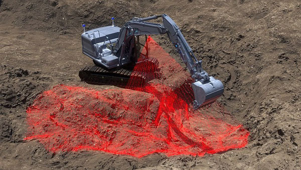
Sodex Innovations, an Austrian company specializing in construction surveying technologies, has unveiled the SDX-4DVision and SDX-Compact machine-mounted terrain mapping systems.
These systems integrate advanced sensor technology and artificial intelligence (AI) driven data processing to create digital twins of worksites while the machine operates. Data is uploaded to the SDX Cloud, allowing for real-time analysis from any location. This allows professionals to monitor evolving site conditions, track inventory through automated volume calculations, and make remote data-driven decisions.
The systems are designed for easy installation on various types of heavy machinery, such as wheel loaders and dozers, making them ideal for construction, mining and civil engineering projects. Their adaptability enables efficient data collection and site monitoring, making them accessible not only to professional surveyors but also to operators and team members who are involved in daily operations.
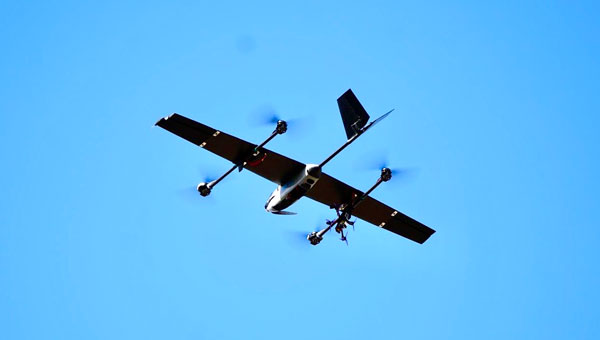
WingXpand, a U.S. provider of autonomous smart planes with artificial intelligence (AI) threat detection capabilities, has collaborated with RTX’s Raytheon. The partnership aims to enhance the capabilities of WingXpand’s smart planes, which already feature a library of AI algorithms designed to provide soldiers with real-time threat identification.
Enhanced threat detection
The smart planes’ open systems architecture allows for the seamless integration of organic and third-party applications and payloads, designed for mission flexibility as threats and tactics evolve. Raytheon’s advanced infrared technology seeks to enhance the capabilities of WingXpand’s smart planes by improving their ability to detect and identify potential threats at greater distances. This integration allows tactical ground units and command leadership to receive more precise, real-time information about their surroundings, facilitating faster and more informed decision-making in the field.
New VTOL capability
In addition to the Raytheon collaboration, WingXpand has introduced a new vertical takeoff and landing (VTOL) capability for its xRAI smart plane. This feature expands the operational versatility of the aircraft, which is designed to be compact enough to fit in a backpack. The VTOL option allows the xRAI to take off and land vertically, making it ideal for operations in tight spaces and challenging environments. WingXpand’s smart planes can be used in both defense and civil missions.
UAVOS has collaborated with a client to conduct extensive testing of UAVOS’ autopilot system, which utilizes computer vision technology. UAVOS’ engineering service supported this testing with its advanced avionics system integrated into its unmanned helicopter.
The UAVOS autopilot system uses computer vision and artificial intelligence (AI) to navigate the UAV in GNSS-denied environments with precision and reliability.
The system’s onboard computer vision-based alternative navigation module, powered by deep learning algorithms, provides the UAVOS avionics system with accurate geospatial coordinates. This innovative approach allows for seamless navigation in both daylight and nighttime conditions, ensuring safe take-off and landing procedures without relying on external GNSS signals. By enabling the drone to effectively “see” and interpret its surroundings, UAVOS has created a solution that grants UAVs unprecedented autonomy and operational flexibility.
The Canadian Coast Guard (CCG) has awarded a contract to Zighra, an artificial intelligence (AI) solutions and cybersecurity provider, for its GenesysInsights platform. This technology will enhance the safety and security of Canada’s maritime territories by providing a previously unattainable level of analysis.
GenesysInsights combines AI interpretability and multi-sensor fusion, designed to offer automated threat detection and comprehensive situational awareness in maritime environments. The platform synthesizes information from Global Navigation Satellite System (GNSS) signals and terrestrial and space-based Automatic Identification System (AIS) data, which aids the CCG in detecting and responding to maritime threats. This initiative is part of the Innovative Solutions Canada program.
Position, navigation and timing (PNT) technology — integral to a range of critical applications, from military operations guidance to everyday smartphone navigation — has propelled commercial advancement. Despite its widespread utility, the susceptibility of these systems to manipulation presents significant threats, including unauthorized vessel activities and sophisticated cyber-attacks, such as jamming and spoofing.
GenesysInsights aims to transform the security of government infrastructure and operations by creating a cyber-secure digital environment across land, sea and space. The platform uses advanced machine learning algorithms to analyze a variety of sensor data inputs. By monitoring ship movements and communications alongside satellite signal integrity, the technology will detect unusual patterns or anomalies indicative of potential risks.
This pilot project will significantly improve real-time monitoring and analysis of maritime activities to boost safety and security across Canada’s maritime waterways.
It can quickly detect and respond to maritime threats, including sophisticated cyber-attacks, and has an integrated operational command system with automated alerts to enhance decision-making and coordination.
The CCG’s successful implementation of GenesysInsights could lead to broader adoptions in various critical infrastructure sectors such as aviation, ground transportation, logistics, space operations and national security, the company said.
Building a solid foundation for any construction requires that the ground be adequately compacted and leveled. Construction workers and contractors operating earthmoving machines know it is nearly impossible to do that by eyesight alone. For a few decades, leveling was accomplished using rotating lasers mounted on tall tripods, which could typically cover a little more than 1,500 ft on a job site and laser receivers mounted on masts on the earth-moving machines. However, these systems only provide elevation, not position, and must be repositioned frequently.
Photo: Steer
In recent years, laser leveling has been increasingly replaced by machine control systems that enable operators to compare the position of their machine’s blade with a digital grading map, and then guide it very precisely to cut the proper elevation. These machine control systems combine global navigation satellite system (GNSS) receivers, to provide the position of the machine; inertial navigation systems (INS), to bridge short gaps in GNSS availability and to provide the platform’s attitude (pitch, roll, and yaw); and a variety of other sensors, to determine the movement of the machine’s attachments, such as booms, arms and buckets.
In this month’s cover story, we feature perspectives on machine control from:
Microchip, which makes inductive position sensors that monitor the angular and linear movements of the attachments.
Septentrio, which makes the AntaRX series of smart antennas.
Besides grading, other areas for machine control include trenching at a specific depth, spot-bulldozing to better prepare a site for grading, mass excavation and contouring edges. Artificial intelligence (AI) will soon start taking over the operators’ duties, but that’s for a future article.
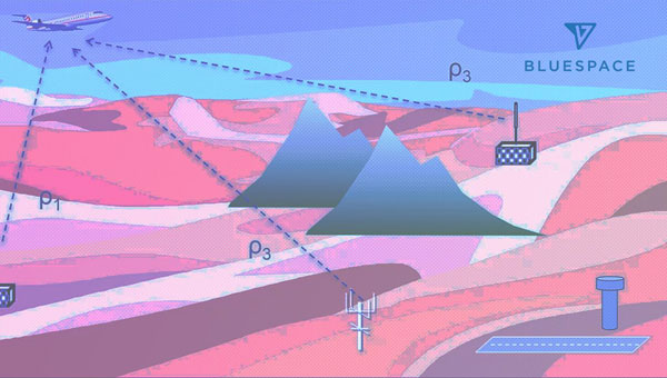
BlueSpace.ai, a Silicon Valley-based company specializing in off-road and unstructured autonomy, has released its assured positioning, navigation, and timing (A-PNT) solution. The solution — called BlueSpace Positioning Solution (BPS) — illustrates how artificial intelligence (AI) can enhance navigation precision in GPS-denied and GPS-degraded environments for both manned and unmanned vehicles.
BPS is designed to address the challenges posed by weak GPS signals, susceptible to jamming, spoofing and unintentional blockages in various environments. It can support a cross-track error, or drift error, of less than 0.3%. This surpasses the industry standard of approximately 1% error over distance traveled. BPS also aims to maintain high performance while using industrial-grade inertial measurement units (IMUs), which leads to improvements in size, weight and power (SWaP).
The AI solution is designed to eliminate geofence limitations and remove dependencies on prior training data and ultra-HD mapping.
BlueSpace.ai has participated in a variety of defense and commercial applications, including applications in challenging underground mining environments, truck and bus automation and off-road autonomy.
IBM, a global technology provider, has released its latest geospatial artificial intelligence (AI) initiative to address climate change. These efforts involve collaborations across various regions and uses advanced AI models designed for geospatial applications.
Central to these initiatives is IBM’s geospatial foundation model, developed jointly with NASA. These models aim to generate environmental insights and solutions related to climate change. Unlike traditional AI models, these use a vast amount of climate-relevant data to accelerate the analysis of various environmental aspects that are affected by climate change.
“AI foundation models utilizing geospatial data can be a game-changer, allowing us to better understand and address climate-related events with unprecedented speed and efficiency,” said Alessandro Curioni, IBM fellow and vice president of Accelerated Discovery.
Analyzing urban heat islands in UAE
IBM and the Mohamed Bin Zayed University of Artificial Intelligence (MBZUAI) have partnered to map urban heat islands in Abu Dhabi using a fine-tuned version of IBM’s geospatial foundation model. The goal of the project is to understand the impact of local landscapes on temperature anomalies, the company said. The initial results show a decrease in heat island effects, which can provide valuable insights for future urban design strategies.
Reforestation and water sustainability in Kenya
In partnership with Kenya’s Special Envoy for Climate Change, Ali Mohamed, IBM is supporting the National Tree Growing and Restoration Campaign. The initiative aims to plant 15 billion trees by 2032, particularly in critical water tower areas affected by deforestation. IBM’s geospatial model powers a digital platform to track tree planting activities, aiding local efforts in restoring forests and measuring carbon sequestration impact.
Elevating climate resiliency in the UK
In collaboration with the Science and Technology Facilities Council (STFC) and Royal HaskoningDHV, IBM is developing AI-driven tools for climate risk assessment in the UK. These tools will focus on assessing weather impacts on aviation operations, the company said. Additionally, the TreesAI research project aims to map areas suitable for tree planting to mitigate surface water flooding and offer urban developers a digital planning platform.
IBM extends collaboration with NASA for weather forecasting
IBM and NASA have partnered to develop an AI foundation model dedicated to weather and climate applications. The collaboration aims to enhance the accuracy and speed of weather forecasting, predict wildfire conditions and understand meteorological phenomena. IBM researchers will work closely with NASA to train and validate this model, IBM said.
The Mobile World Conference (MWC) returns to the Las Vegas Convention Center on September 26 to 28, 2023.
The event will feature exhibition from major U.S. operators, including AT&T business, T-Mobile business, and Verizon business as well as new sessions dedicated to sports and entertainment, software developers and the GSMA’s SEC CON event.
MWC, in partnership with the Cellular Telephone Industries Association (CTIA), invites industry leaders and attendees to connect and discuss topics such as the industry’s transition to a circular economy, the future role of artificial intelligence (AI) in society, and what comes after 5G.
To reflect the United States’ position as a global technology hub and a market at the forefront of 5G innovation, the event is centered around four key themes:
5G Acceleration, as adoption explodes to become the most common mobile technology in North America by 2025.
Age of AI, as the world awakes to the opportunities and challenges of generative AI.
Digital Everything, as the expansion of digital technologies is felt across every industry, from sports and entertainment to manufacturing, financial services and smart mobility.
Enterprise Mobility, as the revolutionary phase of 5G in enterprise is well underway.
The event will feature a variety of keynote speakers, including Amanda Toman, the director for the Public Wireless Supply Chain Innovation Fund at the National Telecommunications and Information Administration (NTIA) within the U.S. Department of Commerce.
For the first time, the GSMA will bring its SEC CON event to MWC Las Vegas on day two, welcoming leading security experts to explore the importance of keeping telecoms infrastructure secure in times of conflict.
A full directory and registration can be found on the MWC Las Vegas website.