Qualcomm has entered a technology agreement with Hyundai Motor Group to integrate its Snapdragon Automotive Cockpit Platform into Hyundai Motor Group’s purpose-built vehicles (PBV).
The infotainment systems on the PBVs will use Snapdragon Automotive Cockpit Platforms for a “holistic, seamlessly connected and smart user experience,” Qualcomm said.
The PBVs are designed to deliver transportation, comfort, logistics, commercial and healthcare services. The latest generation of Qualcomm’s Snapdragon platform benefits from optimized power consumption, high-definition graphics and immersive multimedia and audio.
According to Qualcomm, the latest generation of Snapdragon Automotive Cockpit Platforms offer optimal power consumption while providing top-tier graphics as well as top immersive multimedia and audio experiences.
The platforms offer location services, emergency calling, noise reduction, and dual SIM capability as well as cloud-based monitoring and management systems. Using Qualcomm’s artificial intelligence (AI) engine and machine learning (ML) capabilities for intuitive and intelligent systems, Snapdragon can support digitally advanced applications, including in-vehicle virtual assistance and adaptive human interfaces. It can also facilitate natural communication between the vehicle and passengers for added safety and comfort.
The platform also employs dynamic configuration management to ensure vehicles are kept up to date. Reliable cloud-based vehicle monitoring and management also is possible through cloud service solutions.
Qualcomm and Hyundai Motor Group have been collaborating since 2011 on in-vehicle mobile communications using Snapdragon Automotive Connectivity Platforms.
Image: Kara Capaldo/iStock/Getty Images Plus/Getty Images
Whether preparing for natural disasters or responding to everyday emergencies, first responders depend on the accuracy and dependability of GPS data to keep our communities safe. However, the increasing number and intensity of natural disasters, such as wildfires and hurricanes, and ongoing first responder staffing shortages have pushed the industry to look for ways to combine the tried-and-true benefits of GPS with new artificial intelligence (AI) technology to alert sooner, respond faster, and restore better than ever. The integration of AI’s adaptive learning capabilities with the ability of GPS to operate in areas of low or no connectivity make for cutting-edge emergency service solutions.
New technologies incorporating both AI and GPS have already proven to save time and protect lives by quickly identifying and assessing potential fires. For example, in 2022, Sonoma County, California, used FireScout — an AI-powered fire detection solution — to monitor live footage for signs of fire and alert authorities. In one instance, the county found that FireScout’s AI solution detected and located — using GPS data — a fire 10 minutes before the 911 service was alerted about it, giving responders a head start on containing the fire. FireScout looks to integrate GPS functions more fully into their AI-enabled cameras with exact coordinate information. Investments in innovations that facilitate rapid response to natural disasters will lead to greater safety for first responders and their communities across the country.
One way the industry is investing in GPS-powered AI innovation is through problem-solving competitions such as XPrize Wildfire, which encourages the development of cutting-edge solutions to wildfires. Teams will compete in one of two tracks: the Autonomous Wildfire Response track, which requires teams to combine AI and GPS data to differentiate between high-risk actual fires and decoy fires and then quickly suppress the real fires, and the Space-Based Wildfire Detection and Intelligence track, which requires teams to use satellites to accurately pinpoint fires across vast areas then relay that information to stations on the ground. GPS industry leader Lockheed Martin is providing a $1 million Accurate Detection Intelligence Bonus Prize to the winner of the XPrize Wildfire competition. Competitions such as XPrize Wildfire will result in products that can identify fires faster, reducing response times and minimizing damages to communities.
Additionally, new GPS-powered AI solutions are bringing emergency resources to more people in the wake of hurricanes. In the aftermath of hurricanes, emergency personnel are tasked with identifying and allocating resources to restoration efforts. GPS-powered AI technologies such as the University of Connecticut’s hurricane monitoring system, compare pre-storm and post-storm satellite imagery to spot potential environmental and safety issues, such as flood water or damaged neighborhoods. The system then highlights those areas on a map and shares the coordinates of high-damage areas with emergency personnel. Services such as these support communities and allow restoration efforts to begin sooner with less risk to surveyors and responders.
Beyond natural disasters, GPS also is being used with AI technology to shorten response times for emergency vehicles. Many towns, including St. Louis, Michigan, and Leon Valley, Texas, have implemented AI traffic light systems that use location data to detect the location of ambulances and fire trucks to give the vehicles a path of green lights, clearing out any traffic that might have slowed response times. Similarly, researchers at the University of Southern California are using UAVs — guided and tracked using GPS data — to carry automated external defibrillators (AEDs) to remote locations. These UAVs use coordinates provided by GPS receivers to operate in areas of limited connectivity and AI to determine the most efficient landing locations for different terrains. Ongoing research and further investment into the critical intersections of GPS and AI technology will help promote a safer future by supporting first responders and protecting communities in emergencies.
The GPS Innovation Alliance (GPSIA) welcomes innovations in GPS and AI technologies that continue to revolutionize the way we respond to natural disasters and life-threatening emergencies. GPSIA is proud to support the expansion of these disaster-mitigating solutions by uplifting innovative research and design efforts, promoting new ideas, and ensuring adequate regulation is in place to protect users across the globe.
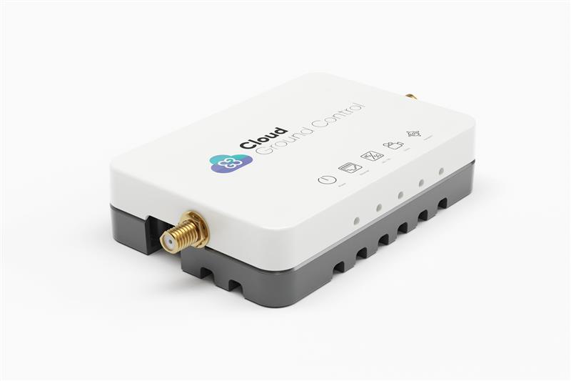
Credit: Cloud Ground Control by Advanced Navigation
Cloud Ground Control, an Advanced Navigation company, has released its cellular micro-modem, the CGConnect. Using 4G/5G networks, CGConnect links UAVs or robotic vehicles to Cloud Ground Control’s cloud-based UAV fleet management platform — enabling live-streaming, command and control from a web browser.
CGConnect can securely connect UAVs and vehicles into one autonomous fleet across land, sea and air, regardless of manufacturer or model. This provides mission planners and operators with full situational awareness for search and rescue, emergency response and disaster relief.
Artificial intelligence (AI) algorithms run in the cloud, relaying real-time camera feed data to the end user to support missions such as object detection, tracking and thermal imaging. The flexible and customizable open platform operates on industry standards, which multiplies potential product applications and enables autonomous vehicles and payloads to operate as a coordinated fleet.
CGConnect’s high-grade security safeguards data and IP from vulnerabilities and security breaches, helping users meet compliance obligations. Additionally, CGConnect supports edge AI to perform intensive object identification and classification directly on the vehicle for dynamic missions.
CGConnect is available for pre-order. An OEM option is also available.
A couple of stories about unmanned air vehicles in the war in Ukraine and a response to the recent Open Letter by the “Future of Life Institute” with more than 200,000 signatures on advanced AI, which urged a six-month moratorium to allow the development of seemingly much needed AI regulations.
The war in Ukraine
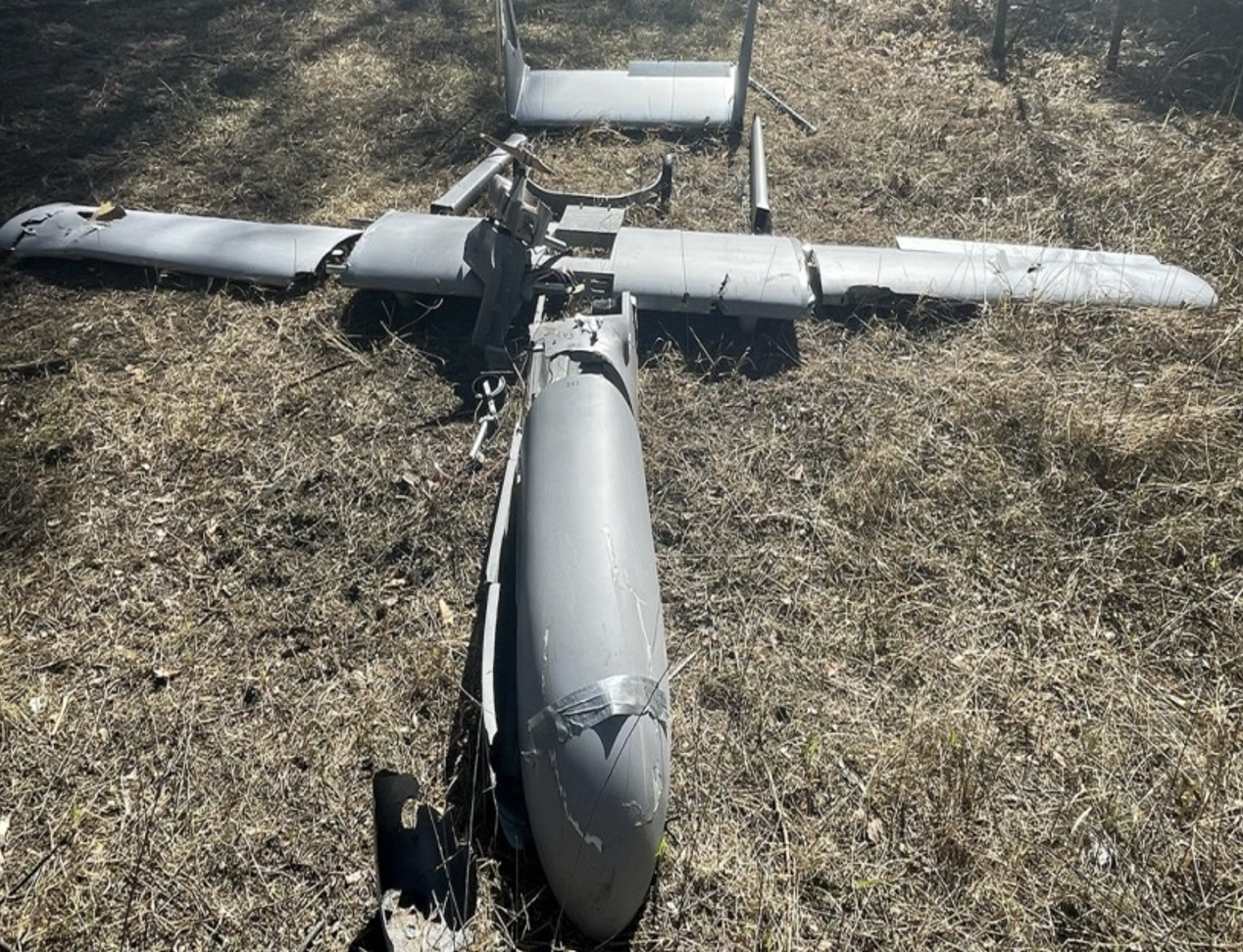
It has been reported that Ukrainian forces were operating the commercially available Chinese Mugin 5 UAV, presumably for surveillance of Russian forces inside Russian-occupied territory. The Mugin 5 can be bought commercially for $10-15,000 and is manufactured by Mugin, which is based in the port city of Xiamen, on China’s eastern coast. In a previous statement posted on the company’s website on March 2, Mugin Limited said that it “condemns” the use of its products during warfare and that it ceased selling products to Russia or Ukraine at the start of the war. However, Russian forces claimed in January 2023 that it had actually shot down one of these Chinese-made UAVs being flown by Ukrainian forces over their territory.
Then, just this week, Ukrainian forces apparently were able to track a low level, slow-moving air vehicle coming at them from Russian occupied territory. After some time, they were able to intercept the UAV, which carried a flashing navigation light, from the ground, and were able to bring it down using small arms. The remains of the crashed UAV were found in a clearing in the forest; a single 44 lb bomb was removed from the wreckage and safely exploded by the Ukrainian team.
Weaponized Mugin 5 following crash in Ukraine forest. (Image: Screenshot from video from Kanal13 Youtube)
Somewhat worse for wear, the Mugin 5 UAV appears to have been held together in places by duct tape and other patches. Is it possible that having shot down a Ukrainian surveillance UAV the Russians recovered these remains and crudely restored the unit to flying and navigating capability, then sent it back to Ukraine owners carrying a bomb? Anything is possible in this conflict.
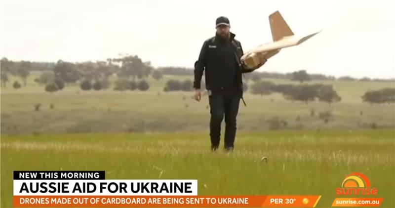
Staying with this conflict and the use of UAVs by both sides, its seems that Australia has come up with a low-cost surveillance UAV that is virtually undetectable and it’s proving quite popular with the Ukrainians. Most defensive detection involves some form of radar scanning, which relies on radar returns bouncing off a flying target. The Australian company SYPAC in Melbourne has developed the Corvo Precision Payload Delivery System (PPDS). It is a wax-coated cardboard UAV, held together with elastic bands and glue, but carrying sophisticated guidance and control electronics.
(Image: Screenshot of video posted by 7 News Australia)
SYPAQ has developed the CORVO UAV under an AU $1.1 m government contract with the objective of creating a low-cost, disposable UAV to deliver urgent needs — such as medical supplies or to resupply small arms ammunition to the Australian military. CORVO is autonomous once launched, using GNSS guidance, or dead reckoning if GNSS signal is lost or jammed. Apparently, hundreds of these disposable UAVs have already been shipped to Ukraine.
While a surveillance role was originally envisaged in Ukraine, it is reported that, “They have been very good at inflicting lots of damage on the enemy,” according to Ukraine’s ambassador to Australia. So, CORVO UAVs may well have already been weaponized.
Open Letter on AI development
Following a recent open letter supported by Elon Musk and Steve Wozniak that proposes a six-month halt on advanced AI development, I was recently approached on behalf of Professor Ioannis Pitas, director of the Artificial Intelligence and Information Analysis (AIIA) lab at the Aristotle University of Thessaloniki (AUTH) and management board chair of the AI Doctoral Academy (AIDA) with somewhat different views.
In order to further the on-going discussion, I thought it would be appropriate to give some space to an alternate view on AI development. So here are some paraphrased comments approved by Pitas:
Could AI research be stopped even for a short time? It is doubtful. Further AI progress is necessary for us to transition from an information society to a knowledge society.
Maybe we have reached the limits of AI research carried out primarily by Big Tech, which appears to treat powerful AI systems as black boxes whose functionality may be poorly understood.
It seems that the open letter reflects welcome and genuine concerns on social and financial risk management. Are expensive lawsuits in an unregulated and unlegislated environment inevitable as a consequence of ill-advised AI pronouncements?
However, it is doubtful whether the proposal for a six-month ban on large-scale experiments is the solution. It’s impractical for competitive commercial and geopolitical reasons, with very few benefits.
Of course, AI research can and should become more open, democratic and scientific.
Here are a number of suggested options:
Should elected parliaments and governments make the important decisions on AI rather than corporations or individual scientists?
Every effort should be made to facilitate the positive aspects of AI social and financial progress and to minimize any negative aspects.
The positive impact of AI systems can greatly outweigh their negative aspects if proper regulatory measures are taken.
It is possible that the biggest threat is that AI systems could deceive too many people who have little related knowledge. This can be extremely dangerous.
We should counter the big threat coming from the use of AI in illegal activities — cheating on university exams is a rather benign use — while the possibility of criminal exploitation may be very much worse.
The impact of AI on labor and markets will be very positive in the medium to long term.
AI systems should be required by international law to be a) registered in an ‘AI global register’, and b) users should be notified when they converse with or use the results of an AI system.
As AI systems have a huge impact on society, and in order to maximize their benefit and socio-economic progress, it is recommended that: o advanced key AI system technologies should become mostly open o AI-related data should be at least partially open.
However, strong financial compensation schemes should be established now for AI technology developers to compensate them for any component that becomes open source.
Well, this is a bit of a departure from our nominal UAV/AI report, but there does seem to be a growing number of voices calling for some form of AI regulation and more extensive discussion might well help this movement come to a conclusion. And it would seem that the U.S. administration is listening, as the U.S. Commerce Department has announced that it is seeking inputs from interested parties for methods to test the safety of AI systems — to ensure that they are “legal, effective, ethical, safe and otherwise trustworthy.” In order to enforce these standards, the department is investigating whether audits and inspections to certify AI systems should be required before their release on the unsuspecting public.
The U.S. Commerce Department is apparently not alone in these concerns, as China is also looking to ensure that systems such as Alibaba Cloud’s Tongyi Qianwen, a competitor to OpenAI’s ChatGPT, are socially beneficial. Meanwhile, following the release of ChatGPT and similar products from Microsoft and Google, awareness has grown of the capabilities of the latest AI tools that generate human-like text passages, and even new images and video. The UK Department for Science, Innovation and Technology and the Office for Artificial Intelligence on the other hand, seem to be looking for an approach to regulation that will not restrict AI innovation.
Geo Connect Asia (GCA) 2023, Asia’s leading international geospatial industry event, will take place March 15-16 at Marina Bay Sands Expo and Convention Centre, Singapore.
GCA 2023 will be held alongside Digital Construction Asia (DCA) 2023, and co-located with the launch of Drones Asia 2023. The three-in-one event, held fully in person, is expected to bring together more than 2,500 delegates and attendees from around the world.
With the theme “Advancing sustainable and resilient geospatial solutions for an interconnected world”, a key focus of GCA 2023 will be the use of advancements in geospatial technology and data interoperability to address regional challenges.
Supported by the Singapore Land Authority (SLA), the event will feature more than 70 exhibiting companies and demonstrate the role played by the mix of geospatial, location intelligence, remote sensing and drone-based solutions.
The two-day in-person conference comprises ten main sessions featuring more than 50 prominent industry speakers, panelists and moderators.
Shining light on opportunities for enhancing productivity in the construction world, DCA 2023 will focus on showcasing digitalized processes and improved workflows. By enhancing ground-based equipment with aerial capabilities and implementing technology — such as artificial intelligence (AI), building information modeling and internet of things — current challenges in construction can now be targeted via novel and more efficient approaches.
Drones Asia 2023 will address the commercial UAV industry. The newly launched and co-located show aims to create a focused platform for the complete drone ecosystem.
Drones Asia 2023 plays a critical role in enabling AI in today’s geospatial marketplace, broadening the conversation as industry experts investigate the application of UAVs in the commercial and industrial world, exploring industrial adoption to improve productivity and efficiency.
For the full programme and registration, visit the GCA 2023 website.
Advanced Navigation, a developer of AI robotics and navigation technology, has raised $68 million in a Series B funding round. The Series B round was led by global investment firm KKR.
The funding round includes participation from new investors such as deep learning venture firm AI Capital and existing investors, including Main Sequence, the Hon. Malcolm Turnbull AC, In-Q-Tel, and Our Innovation Fund, bringing Advanced Navigation’s total amount raised to more than $85 million.
Advanced Navigation supplies solutions to some of the world’s largest tech companies, such as Fugro, NASA, Tesla, Google and Boeing. The funding will be used to develop AI technologies and expand autonomy beyond its current scope, including solutions to help guide driverless vehicles, flying taxis, space crafts, drone deliveries, autonomous farming and deep sea robotics. The company will also assess inorganic growth opportunities to incorporate new technologies and products into its suite which complement the company’s existing products and areas of expertise.
Louis Casey, KKR’s growth technology lead in Australia, New Zealand, and Southeast Asia, said, “Advances in autonomous navigation technology that leverages AI to reduce sensor cost while improving performance can rapidly increase enterprise and consumer applications globally. We are very pleased to work alongside the Advanced Navigation team to support the company’s growth.”
In addition, Louis Casey and Vance Serchuk, Executive Director of the KKR Global Institute, will join Advanced Navigation’s board of directors. General David Petraeus (U.S. Army, Ret.), Partner, KKR and Chairman of the KKR Global Institute, will chair a new advisory committee that targets to support the company’s global expansion efforts.
Europe’s 2nd Horizon Europe call has been launched for European GNSS, Galileo and Earth observation projects, offering total funding of €48.1 million.
The Horizon program is managed by the European Union Agency for the Space Programme (EUSPA). It funds research and innovation by small and mid-size enterprises, academia, public actors and others that will stimulate development of space applications and solutions using EUSPA data and services.
The 2nd call aims to to strengthen downstream capabilities and modernize the EU public sector by offering cutting-edge solutions based on Galileo, Copernicus, EGNOS and GOVSATCOM.
Funding is being offered for projects that make use of Galileo and EGNOS in smart mobility applications. Other projects fuse Copernicus data with artificial intelligence to boost the European economy and help modernize the public sector. For the first time, the call seeks to deliver satellite communication use cases based on the forthcoming GOVSATCOM system.
Below is a breakdown of the funds’ distribution per thematic area.
Visit the EU’s funding & tender opportunities portal for detailed information about the EUSPA call and the topics available. The deadline for applications is March 2, 2023.
Hexagon’s Safety, Infrastructure & Geospatial division announced the addition of artificial intelligence to HxGN Connect, Hexagon’s real-time incident center as a service solution.
HxGN Connect provides crime and operations centers with real-time views of different data sources, collaboration channels to coordinate across teams and the ability to add new participants and channels as needed. The AI capabilities autonomously analyze diverse data types from incidents, assets, cameras, units, alarms and more, issuing proactive notifications and alerts based on observed trends and deviations.
Having access to diverse information and intelligence in real-time enables police, emergency management, transportation and other organizations to evaluate a situation and deploy resources faster, while continuing to coordinate and dynamically respond as situations change.
“Some organizations operate in silos, without access to data or the ability to act on it,” said Kalyn Sims, Chief Technology Officer, Safety & Security, Hexagon’s Safety, Infrastructure & Geospatial division. “[HxGN Connect] breaks down silos within departments and across jurisdictions, and it mines data in real-time to deliver insights. The result is quicker and better responses to incidents and emergencies.”
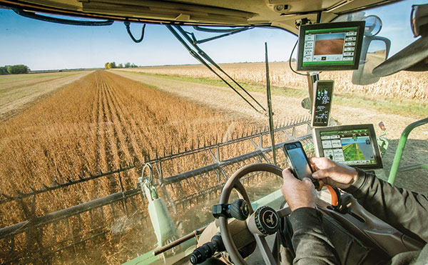
Fuel and fertilizer prices are at all-time highs, as farmers the world over are scrambling to find ways to stay financially afloat. Large commercial farms have long had a leg up over smaller holdings. They already have access to artificial intelligence (AI) and cutting-edge hardware to plan their operations and automate tasks. They run broad sensor networks to monitor soil quality, operate vision-enabled drones to monitor crop health, and let autonomous tractors steer across their fields to vastly improve their productivity.
These advanced systems have been prohibitively expensive, to the point that their costs are hard to justify for smaller holdings, less than two hectares in size, which make up the vast majority of the world’s more than 570 million farms. Many of these farmers simply don’t have access to sufficient capital to invest in new equipment, and continue to rely on older machines and human labor. For them, the vast promise of the digital revolution to increase the efficiency of agricultural operations — typically lumped together as smart farming or precision agriculture — has long remained just out of reach.
But change is in the air. Over the past few years, the popularization of the internet of things (IoT) and its underlying technologies has led to the development of a new and more affordable generation of precision farming solutions. These solutions are giving smallholdings tools to increase the quantity and the quality of their production. Combining satellite-based positioning, wireless connectivity and visual sensing with advanced algorithms including machine learning (ML) and artificial intelligence, these solutions promise to help farmers produce more for less, putting them on more equal footing with their larger commercial competitors.
In this article, we take stock of key trends driving the democratization of precision agriculture. We zoom in on some of the concrete applications transforming the operations of smaller farms the world over. We start by exploring the core enabling technologies, the applications they enable, and where they are headed.
Technological evolution on all fronts
Sensor-fusion platforms
At their heart, precision agriculture solutions are sensor fusion platforms, taking in data points from a variety of sensors, using algorithms to make sense of them, and extracting insights on which their users — machine or human — can act. As they mature, these sensor fusion platforms are becoming increasingly complex, crunching more and more types of sensor data with algorithms of growing sophistication to gain ever deeper and higher value insights.
These insights are often generated using AI and ML models that run at the edge of the network near the sensors — on the tractors, sprayers, or other devices themselves — rather than in the cloud.
Equipment manufacturers looking to integrate AI/ML at the edge are weighing their options in terms of adding application processors and hardware accelerators capable of running advanced ML models needed to fuse camera and sensor inputs to make real-time decisions. To simplify the adoption of AI/ML at the edge, many vendors are starting to integrate AI accelerators into their modules and systems-on-chip (SoCs), lowering the barrier to entry.
Original equipment manufacturers (OEMs), for their part, are choosing to integrate these SoCs even if their software capabilities are still behind. For them, building solutions with future-proof hardware is a potentially lucrative strategy for generating recurring revenues through firmware updates that provide advanced functions down the road.
Despite the abundance of evaluation kits from major vendors, scaling from prototypes to production with these solutions can be expensive. While integrated sensor fusion platforms with, for example, pre-loaded dynamic vehicle models for auto-steering or computer vision models for plant health can accelerate development for OEMs and reduce the need for software investment, they can be too generic and may not solve use-case-specific needs. More focused AI/ML may require more investment in data collection and training models, which, due to their proprietary nature could come at a higher price.
Camera systems are already widely relied on by autonomous tractors, visually monitoring the surrounding environment and feeding their data into computer-vision solutions where it is parsed. Context-rich, vision-based data can help optimize the distribution of agricultural inputs such as water, seeds, fertilizers and pesticides using real-time variable spray-rate control based on plant size and other metrics to significantly improve efficiencies and reduce overall costs.
Camera systems come with a set of challenges that need to be carefully managed. Lenses can become contaminated with water, debris, dust, and snow. Even though these issues impact all vision-based applications, including mass-market applications such as automated and autonomous driving, there are still no reliable methods of keeping them clean, aside from water-spraying nozzles (that can cause buildup on the lenses) and old-fashioned manual maintenance.
Additionally, the steep price of high-resolution cameras can drive up the cost of end solutions, as can data storage and communication when the visual data is processed in the cloud.
Global navigation satellite systems
Satellite-based positioning has also become a staple in precision agriculture solutions. Autonomous and guided tractors use the technology to drive vehicles along precise paths to increase pass-to-pass efficiency and reduce overlapping rows. Crop monitoring drones use GNSS technology to patrol predefined flight paths. And fully autonomous guided vehicles such as robotic lawnmowers use it to avoid restricted no-go zones. The latter three applications typically require centimeter-level positioning accuracies.
Centimeter-level GNSS technology has been available for well over a decade, with farmers subscribing to relatively costly GNSS correction services tailored to each user. However, it was only with the advent of affordable RTK services with availability in rural areas, as well as the dramatic decrease in cost for farmers to deploy their own RTK base stations using low-cost modules, that the price point of high precision positioning has come down far enough to make the service affordable to all but the least lucrative operations.
High precision GNSS technology brings the benefits of improved pass-to-pass efficiency – a general reduction of all agricultural inputs with all the financial, environmental, and health benefits that this entails. At the same time, it requires solutions to deal with signal delays and the resulting inaccuracies of multipath effects, caused when signals bounce off buildings, mountains, or other solid structures on their way to the GNSS receiver.
When delivered via the internet, the GNSS augmentation data stream requires an IP connection to the provider’s server. This poses challenges for farms that lack infrastructures such as Wi-Fi base stations, sub-GHz RF systems, or cellular network coverage.
Photo: Avalon_Studio/E+/Getty Images
Wireless connectivity
In some way or another, all advanced precision ag use cases depend on wireless connectivity. Environmental sensors and inspection drones need it to relay data to the cloud backend. Additionally, tractors, drones, and other farm robots depend on it to upload telematics data, report their status, enable predictive maintenance tools to reduce downtime, and receive GNSS augmentation data for high precision positioning.
While cellular connectivity is the easiest to use — all it takes to upload data straight to the cloud is a mobile data subscription and a SIM card — it has two key drawbacks. The first, mentioned earlier, is that the entire farm needs robust network coverage, which is not always a given in rural areas even in the United States and other developed countries. Also, when coverage is available, the cost of data transfers can quickly add up and become prohibitive for smaller, less profitable farms, as they may not be able to negotiate affordable connectivity plans as effectively as larger operations that have much higher data usage.
One way to address the coverage issue is by choosing the right wireless communication technology. Low power wide area technologies, such as LTE-M, NB-IoT, and Cat-1 solutions offer similar coverage to traditional LTE in many countries and are available at a fraction of the cost. When higher bandwidths are required, LTE Cat 4 or higher modules offer 150 Mbps+ of throughput. 5G modules enabling gigabit connectivity are available today, but solutions may cost up to 10-times more.
As an alternative, 5G Redcap – an upcoming 3GPP technology – seeks to provide a 5G compatible, affordable solution with medium bandwidth and lower complexity, enabling affordable hardware. We will likely start to see the first RedCap offerings from mobile network operators in 2025.
Artificial intelligence and machine learning at the edge offer an additional tool to reduce bandwidth requirements, by processing sensed data near the sensors themselves. Rather than streaming vast amounts of raw sensor data to the cloud, devices leveraging edge intelligence can reduce their wireless communication bandwidth requirements and cost by uploading only relevant information.
The trends driving democratization
Progress in sensing and sensor fusion platforms, camera systems, GNSS technology, and wireless connectivity is but one of the drivers democratizing precision agriculture. The other is an ongoing ecosystem-wide transformation that is breaking down many of the barriers that have kept precision agriculture solutions the preserve of large, lucrative farming operations.
Together, they are bringing down the cost of ownership of precision ag technology. Only just a few years ago, the only available solutions from major OEMs came with a hefty price tag, comprising expensive hardware and considerable recurring subscription fees, while requiring skilled labor to implement, operate, and maintain smart equipment.
Vendor lock-in enforced by locking telematics interface ports prevented farms from adopting aftermarket solutions — justified as a way to improve safety and vehicle reliability. Ultimately, however, this limited farmers’ ability to maintain their equipment themselves and to piece together cost-optimized solutions tailored to their specific needs using components from competing solution providers.
Today, all of this is changing. Hardware costs are down dramatically due, largely, to economies of scale unleashed by the Internet of Things’ explosive growth. Farmers now have access to affordable, user-friendly aftermarket solutions to upgrade tractors and other agricultural machines they already own that depend on a new generation of more cost-effective GNSS correction services. OEMs are introducing advanced functionality in their entry- to mid-range tractors in addition to their premium product line.
At the same time, the abundance of open-source projects, module-based solutions, and pre-certified radio technologies are making the development of precision ag solutions cheaper, bringing down the cost of off-the-shelf hardware. Add to that lower subscription costs for GNSS correction services thanks to improved broadcast distribution with SSR-RTK (state space representation-real-time kinematic).
The total cost of connectivity is dropping as well. Deploying connectivity infrastructure was long a non-negligible cost point, made up of wireless infrastructure and data subscription fees. Today, thanks to the increased availability of cost- and power-optimized wireless communication technologies with broader coverage (LTE-M, NB-IoT, LTE Cat 1), farmers can reap the benefits of the overall expansion of cellular network infrastructure.
Arguably one of the most promising trends driving the democratization of precision agriculture technology comes from the farming community itself in the form of do-it-yourself solutions based on open-source hardware and software designs.
Take AgOpenGPS, also referred to as AOG, an open-source auto-steering solution created by a Canadian farmer and software developer. AOG delivers all the hardware design files, the real-time microcontroller firmware, and software required to enable auto-steering on conventional tractors, regardless of their age. Thousands of hours invested by the AOG developer community have made the solution accessible to the masses, both financially — retrofitting tractors can cost less than USD $1,000 — and in terms of prerequisite knowledge.
A growing variety of precision agriculture platforms, from high-end commercial solutions that cater to the most profitable farms to low-cost do-it-yourself solutions that can pay for themselves in a year and are accessible to smaller, less profitable operations, are transforming the impact that precision agriculture can deliver. With the global food supply under tremendous pressure, this democratization of smart farming technology could come to play an important role in feeding the world.
To learn more about how u-blox enables high-precision autonomous vehicles and other smart farming applications, visit www.u-blox.com/precision-agriculture.
What role do artificial intelligence (AI) and machine learning (ML) play in analyzing GNSS signals? How might that evolve?
Ellen Hall
“ML is gaining adoption across many GNSS application areas due to its ability to extract data and classify signal information often within complex operational environments. By combining ML with AI, systems are now able to characterize receiver correlator outputs and ranging residuals, and then fuse this with identified environmental features — all potentially increasing GNSS accuracy, integrity and availability. As AI and ML mature, we can expect to see new novel methods to optimize PNT sensor-fusion engines. This will include the combination of GNSS signals with other sensor signals such as inertial and vision.”
— Ellen Hall
Spirent Federal Systems
Bernard Gruber
“AI will come to the battlefield and I would like to think that AI and ML will play a large part in GNSS solutions and specifically protection from adversaries in the future. As AI can ‘anticipate’ threats (i.e., spoofing, jamming, poor coverage) based upon what it sees and knows one should be able to reduce the cycle time to combat that threat (e.g., find/fix/identify and then target, change frequencies, evade). Seeing this data, ML can adapt to morphing threats as well as ‘fuse’ data from all different domains (air, space, sea and land) to provide solutions.”
— Bernard Gruber
Northrop Grumman
Jules McNeff
“I would like to turn the question around and ask ‘How does GNSS contribute to enabling AI and ML to function in physical space?’ Many AI and ML experts don’t think about this aspect of the technologies. Of course, timing is essential to AI and ML operation, but both must be spatially oriented as well if they are to interact effectively with things in the ‘real world.’ The more complex the interactions, the higher the need for precise, continuous PNT information. Depending on the applications, the relationships can become synergistic.”
— Jules McNeff Overlook Systems Technologies
Greg Turetzky
“AI and ML have a great opportunity to fundamentally change the way GNSS signals are used for positioning. In particular, the new modernized signals with wider bandwidths and higher chipping rates create a fundamentally richer data set than classic range/range rate measurements. By analyzing the channel response and using AI/ML techniques, the entire signal environment of LOS and NLOS signals can all be used to make more accurate measurements. In fact, in deep urban canyons with appropriate training, it is even possible to accurately position using only multipath signals such that more multipath makes the position more accurate, not less.”
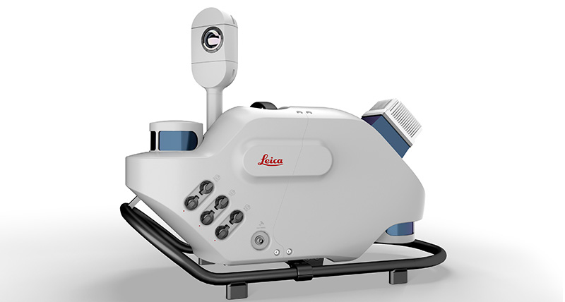
Leica Geosystems, part of Hexagon, has introduced Leica Pegasus TRK, a reality-capture mobile-mapping system that features artificial intelligence (AI), autonomous workflows and intuitive interfaces.
The Pegasus TRK features an AI-enhanced camera and automatic camera calibration. To comply with privacy regulations, its AI can identify and blur identifiers, such as people and vehicles, in real time.
Features include advanced dynamic laser scanning and an expandable imagery system for recording, measuring and visualizing environments. It also increases productivity with automated, intelligent workflows.
Light enough to be operated by one person, the Pegasus TRK is user-friendly, able to be used by professionals new to the technology. Its reliable, high-quality deliverables serve the needs of technical experts in various industries, including surveying, transportation and utilities.
The Pegasus TRK solution enables long-range mobile mapping for applications in asset management; road construction; rail and critical infrastructure; oil, gas and electricity industries and more. The system also is suitable for creating high-definition base maps for autonomous vehicles.
The Pegasus TRK connects with the new powerful Leica Pegasus FIELD software for fully autonomous and secure data collection and route planning in the field. It also connects with Leica Cyclone Pegasus OFFICE for seamless input into post-processing and publishing workflows.
“The Pegasus TRK solution is the most efficient mobile mapping product we’ve tried so far,” said Raymon Somford, CEO and owner of Rise3D. “It is lightweight and easy to use, guiding our team through the process of data collection. Its sensors that trigger automatically avoid missing details. We can achieve quality images regardless of the conditions, making mobile mapping almost effortless.”
“The Pegasus TRK solution offers flexibility, true-to-life image clarity and best-in-class accuracy while making mobile mapping more accessible and easier than ever before,” said Christian Schäfer, business director, Mobile Mapping at Leica Geosystems. “There is a growing demand for more autonomy. This solution raises the bar in data collection with automated route planning, guidance and collection processes that increase efficiency, improve data quality and reduce project costs.”
The Pegasus TRK will be a featured Tech Highlight at Hexagon’s flagship digital-reality solutions conference HxGN Live Global in Las Vegas, which takes place June 20-23.
A new platform will detect and characterize GNSS spoofing operations using artificial intelligence and commercially available data
Geospatial intelligence company Orbital Insight has been awarded a contract from the U.S. Department of Defense (DoD) to deliver a technology platform for identifying intentional GNSS interference and manipulation operations across the world.
The platform will leverage commercially available data to detect GNSS spoofing, where falsified or manipulated GNSS signals are used to confuse adversaries or obscure illicit activities, presenting risk to both government and commercial operations. Orbital Insight was selected through DoD’s Defense Innovation Unit (DIU) solicitation process seeking commercial solutions to counter the growing threat of GNSS disruptions to national security.
Research suggests that Russia conducted nearly 10,000 spoofing operations from 2016 to 2018 alone.
The new technology will significantly improve situational awareness for warfighters, intelligence analysts and safety-of-life applications. Orbital Insight’s platform will leverage its multisensor data stack, artificial intelligence and machine-learning capabilities to alert analysts and operators to potential jamming and spoofing events, techniques commonly used by adversarial actors to cover up activities or sabotage operations.
The platform leverages a suite of geolocation data — satellites, AIS, ADS-B and internet-of-things devices — along with new advanced algorithms designed to automatically recognize anomalies linked to spoofing, complemented by research intelligence from the nonprofit partner Center for Advanced Defense Studies. Research suggests that Russia conducted nearly 10,000 spoofing operations from 2016 to 2018 alone.
“Helping organizations understand what’s happening on and to the Earth is at the heart of what Orbital Insight does, and spoofing is a national security problem that has proven challenging to solve,” said Kevin O’Brien, CEO, Orbital Insight. “GNSS spoofing is essentially a data problem, and Orbital Insight’s AI and deep data stack can help identify spoofing, along with other major humanitarian and environmental challenges. This is a perfect example of private and public sectors uniting through technology.”
Other areas that may be addressed: identifying drug trafficking, illegal fishing, sea-borne piracy and unintentional commercial aviation disruptions
The technology has broad implications that extend beyond situational awareness of intentional GNSS interference. Other national security, humanitarian and environmental challenges may be addressed, such as identifying drug trafficking, illegal fishing, sea-borne piracy and unintentional commercial aviation disruptions.
Federal agencies are increasingly complementing their systems with commercial technology and data sources that are unclassified, universally accessible, and shareable with allies. The National Air and Space Intelligence Center will be the first customer to utilize the technology. Upon successful integration, the goal will be to expand this platform widely across the defense, intelligence and civil communities.
Orbital Insight received the DoD contract on the heels of announcing a Phase II Small Business Innovation Research contract from the National Geospatial-Intelligence Agency to deliver a computer-vision model that uses synthetic data to detect novel classes of objects.
The company also recently launched a new class of multiclass object-detection algorithms within its flagship GO platform to help the intelligence community monitor and differentiate activity at thousands of areas of interest. Like all of Orbital Insight’s products, these algorithms are being developed within an ethics framework that shapes the company’s work and values privacy.