Tag: Australia

  • Cohda Wireless demos self-driving connected cars on city streets

    Cohda Wireless demos self-driving connected cars on city streets

    Cohda Wireless has successfully demonstrated its connected autonomous vehicle technology in a live trial on the streets of the city of Adelaide, Australia.

    The trial proved the potential for connected self-driven vehicles to make streets safer and that Cohda’s technology is effective even in challenging urban canyons.

    In an area covering two city blocks east of Adelaide’s Victoria Square, the demonstration replicated a scenario that is a daily occurrence on the streets of cities all over the world.

    In the scenario, two vehicles approach a four-way intersection at right angles to each other. Car 2, driven by a human, fails to adhere to the red-light signal and approaches the intersection at speed, intending to “skip” the red light. Car 1, a connected autonomous vehicle, is approaching the intersection from another direction and intends to proceed through the intersection on the green light.


    In a real-life scenario, there would be a risk of a collision as human drivers will invariably approach the intersection when the light is green, fully confident that all other road users will obey the traffic signals. In an instance where Car 2 disobeyed the traffic signal and Car 1 was unable to see the approaching danger, due to visibility being obstructed by buildings or other infrastructure, a collision would be especially likely.

    But as Cohda Wireless’s Chief Technical Officer Professor Paul Alexander explained, if the vehicles were connected using Cohda’s V2X (Vehicle-To-Everything) technology, a potential collision situation would be detected and avoided well in advance of it actually happening.

    “We demonstrated that when vehicles are connected to each other using our smart V2X technology, Car 1, the connected autonomous vehicle, would detect that Car 2 is approaching the red light at speed and is probably not going to stop. This allows the connected autonomous vehicle to pre-emptively identify and respond to the threat by slowing down and stopping.”

    “Cohda’s V2X technology allows vehicles to ‘speak to each other’ to extend their perception horizon,” added Alexander.

    “The technology provides the vehicle with an awareness of its environment and risk factors associated with it, consistently and accurately up to ten times per second, enabling it to make decisions that a human being would not be capable of making as the driver of the vehicle.”

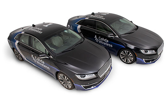
    Cohda’s Smart Cars Smart City initiative was funded by the South Australian Department of Transport and Infrastructure’s Future Mobility Lab Fund. In June this year, Cohda Wireless took ownership of two specially-modified vehicles from the U.S. that it is using in advanced trials of its V2X (Vehicle-To-Everything) technology.

    The two Lincoln MKZ sedans were fitted with the ADAS (Advanced Driver Assistance Systems), ROS (Robot Operating System) various sensors including lidar, radar, cameras, GPS as well as in-vehicle compute platform and Cohda’s GNSS- independent positioning technology.

    The fusion and cooperation of the various sensors and Cohda’s V2X technology augment the vehicles’ perception capability and make the autonomous vehicles features more practical, to include threat detection, the dangers associated with blind intersections and vulnerable road users, the company said.

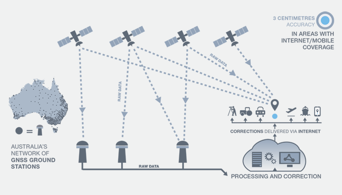
    “Our goal today was not only to demonstrate the efficacy of our technology in enabling self-driven vehicles to communicate with each other, but also to do so in a city environment where so-called ‘urban canyons’ significantly affect the ability of systems reliant on Global Navigation Satellite Systems (GNSS) to achieve accurate positioning,” Alexander said.

    “The area in the city of Adelaide in which the trial was conducted was one such urban canyon where positioning through GNSS can be off by up to 40 meters, but with our V2X Locate technology positioning accuracy is improved to within a meter.”

    Photo: Cohda Wireless
    Photo: Cohda Wireless

    Cohda Wireless demonstrated the efficacy and accuracy of its V2X-Locate system in a 2017 trial in New York City where it repeatedly demonstrated sub-meter accuracy while driving along Sixth Avenue, which has the tallest buildings in the Big Apple. Comparably tested GPS-based systems were as much as tens of meters off-course, at times showing cars driving through buildings.

    Cohda’s V2X technology underpins and complements other technology used by autonomous vehicles such as cameras, sensors, radars and lidars by enabling cooperative perception.

    “The role of technology in making our roads safer is probably not generally understood but we hope that this demonstration has helped to prove that with the appropriate technology and infrastructure, connected self-driving vehicles are safer to have on our roads than vehicles controlled entirely by human beings,” added Alexander.

  • Hurricane cleanup, shark patrol top UAV applications

    Another month, another hurricane in the southern United States. News channels showed drone-captured video of the mess left behind in Northern Florida, Georgia and the Carolinas. More useful is the video damage assessments UAVs are providing for first responders.

    A basketball hoop and backboard hang forlornly while both front and back walls of a school gym are gone, huge buildings are nothing but matchsticks, fallen trees and powerlines blocking roads — familiar scenes from hurricane Michael’s devastation of Panama City and area — video provided by drones operating in the disaster zone.

    Although the videos have now largely gone from the TV news, Panhandle residents will be living through this nightmare for months to come.

    Photo: Glenn Fawcett/Customs and Border Protection/Handout)
    Photo: Glenn Fawcett/Customs and Border Protection/Handout)

    Working with emergency teams — including the North Carolina Surf City Fire Department, Airborne Response, Florida FEMA Task Force and Missouri Task Force FEMA — Edgybees’ AR drone software was able to provide collaborative, real-time, situational visualizations of the areas affected by Michael. Status and location updates were available during critical missions, and key geographical data was provided to teams on the ground.

    Beach Patrol

    Another life-saving drone application comes from the other side of the Pacific – finding and deterring sharks which threaten bathers off the beaches of Australia.

    Shark deterrent tests.(Photo: Flinders University)
    Shark deterrent tests. (Photo: Flinders University)

    An artificial intelligence application on-board a SharkSpotter UAV monitors for shark attributes as it overflies inshore areas where the predators are known to hunt. If there is a match for typical shark behavior — size, shape, color, and movements in the water — an alert is transmitted to enable lifesavers to respond. The drone can even drop a flotation device to swimmers in trouble. A number of beaches in New South Wales were patroled this past summer, and many more UAV beach patrols are planned to be added for the coming season.

    SharkSpotter drone. (Photo: Ripper Group)
    SharkSpotter drone. (Photo: Ripper Group)

    Other work is underway to deter the animals using devices in the water which create electric fields aimed at interfering with shark sensory systems. Another cell-phone application estimates the probability of the presence of sharks based on a number of environmental factors. Several U.S. agencies are keenly watching these developments as shark attacks have increased here, off both Atlantic and Pacific beaches.

    Meanwhile, there has been another important step forward for drone integration into the US National Airspace System (NAS) and for integration in other countries’ airspace. Enabling drones to fly over people and property is a key part of potential airspace operations, and a safe recovery system which avoids possible injury to people is becoming essential. Most drones have a return-to-base fallback in the event of loss of the control signal, but this doesn’t help in the event of a fundamental mechanical failure.

    Parachute Recovery Systems

    DJI Matrice 600 with DRS-10 rescue system. (Photo: Drone Rescue)
    DJI Matrice 600 with DRS-10 rescue system. (Photo: Drone Rescue)

    Effective auto-release parachute systems may be key to solving this problem. Another supplier has emerged with a lightweight automatic system for the DJI Matrice 600 multicopter.

    Drone Rescue (DR) from Austria has announced its DR-10 parachute recovery system,for drones weighing 5-20 kg (11-44 lb). The DR-5 system is for lighter UAVs (8kg – 17.6lb).

    The DRS-M600 system has apparently been derived from the DR-10 specifically for the DJI Matrice drone.

    Photo: Drone Rescue
    Photo: Drone Rescue

    The parachute is mounted in a carbon cage and is released when a self-contained electronics system automatically detects an imminent crash. DR claims that their system works even in the event of control data link failure, and that incident data is collected in an on-board UAV flight-data recorder for subsequent analysis.

    It was previously announced that an FAA waiver for flight over people was granted to North Dakota UAS operator, Botlink using a ParaZero Israel drone recovery parachute system.

    Initial flights were conducted during a tailgating event prior to the North Dakota State University vs South Dakota State football game in North Dakota. The drone flew over crowds in the stadium’s parking lots and provided real-time video for local law enforcement and media companies.

    This drone parachute safety system includes a fully autonomous triggering system that deploys quickly and reliably without being dependent on any manual operator’s response. During FAA testing it was necessary to demonstrate that the descent rate was slow enough to provide acceptably low impact energy and that the system would operate correctly in multiple types of failure conditions.

    DHL Drone Delivery

    Meanwhile, DHL has joined other drone delivery companies to establish a medical delivery trial in Africa. DHL’s trial is in the Lake Victoria region of Tanzania.

    The six-month trial has focused on delivered medicines by UAV within 40 minutes to an island in Lake Victoria — the trip normally takes six hours by road.

    Photo: DHL
    Photo: DHL

    Over the course of 160 proving flights, using a 4-kg-capacity Wingcopter, medical supplies were successfully transported over the 60 kilometers between Mwanza and the hospital on the island of Ukerewe.

    The medicines reach their destination at least 3 hours earlier than by any traditional mode of transportation, and as a result of these tests, 400,000 people in the Ukerewe District will now have access to medical care and support in hours rather than days.

    Conclusion

    Drones helping out hurricane Michael recovery efforts in the Florida Panhandle, specialized drones tracking sharks to mitigate possible attacks off beaches in Australia, parachute recovery systems enabling drone flights over people, the integration of drones into regular airspace moving ahead, and more medical delivery trials in Africa. These are a few recent UAV applications that appear to be supporting even further drone use around the world.

  • Spookfish expands coverage with New South Wales imagery

    Aerial imagery specialist Spookfish has expanded its capture program into New South Wales (NSW), now covering the NSW coast and Sydney’s entire metropolitan area. Spookfish’s coverage in NSW now spans from Newcastle to Kiama and from Lithgow to Manly.

    The expansion into NSW marks the next stage of a nationwide rollout for Spookfish. In the past 12 months, the company has expanded coverage into the South Australian, Victorian, Australian Capital Territory and now NSW markets, in addition to its Western Australian coverage.

    The expansion of coverage will give businesses and government agencies across Sydney and regional NSW the opportunity to access high-resolution aerial imagery and save thousands of dollars by reducing the time spent on site.

    Spookfish now covers the entire Sydney metropolitan area, home to 71% of the NSW population. The city’s growth presents development opportunities for businesses, all of which need to fit within city planning regulations. High-resolution aerial imagery will play an important role in the planning stages.

    Spookfish also captures regional cities and towns, including Albury and Wagga Wagga, at the same consistent specification as capital cities.

    With the addition of Perth, Melbourne and Adelaide’s entire metropolitan areas, Spookfish offers users access to more than 55,000 square kilometers of high-resolution imagery across Australia. The platform provides customers a clear view on any device with no data caps to give users access to unlimited high-resolution aerial imagery without the risk of unexpected costs.

    “Sydney has the greatest population density in Australia, and continues to grow with new projects commissioned to meet this growing population,” said Jason Waller, Spookfish CEO. “We are very pleased to be able to offer businesses access to high resolution imagery of this unique city, to help drive effective and precise planning of developments and urban areas.

    “Every day our platform is being discovered by many Australian businesses, helping them save time and money by providing precise aerial imagery with the timeliness and convenience of cloud delivery. We offer our customers a service like no other, where they can access extremely high resolution images at an affordable price across very large areas, with no data caps.”

    Spookfish utilizes a fleet of specialized planes to capture imagery for its platform. With regular updates in capital cities across Australia, customers have an up-to-date and evolving view of their world.

  • QZSS satellites benefit Western Australia industries, study shows

    Curtin University researchers found the launch of new Japanese satellites has boosted satellite positioning capabilities in Western Australia (WA), offering huge potential benefits across numerous industries including mining, surveying and navigation.

    New research, published in the journal GPS Solutions, found signals from the recently launched Japanese QZSS satellites provide centimeter-level positioning accuracy, and thus significantly enhanced positioning capabilities in WA, thereby improving accuracy, reliability and availability.

    Lead researcher Professor Peter Teunissen, of Curtin’s School of Earth and Planetary Sciences, said these results will improve further when the QZSS signals are combined with those from other satellite systems such as the Indian NavIC system.

    Teunissen said the analyses done by Curtin’s GNSS Research Centre demonstrated the highly accurate centimeter-level positioning capabilities that can now be achieved.

    “Such improved positioning, accuracy and reliability would offer great benefits when applied in fields such as open-pit mining, surveying, hydrography, automated navigation, structural health monitoring, and subsidence and tectonic deformation monitoring used in the geospatial industry,” Teunissen said. “The benefits are not only restricted to positioning, but cover the whole range of satellite signal applications, including atmospheric sensing (ionosphere and troposphere) as used for climate change and space weather studies, and numerical weather prediction.”

    Teunissen said WA was in the fortunate and unique geographical position of being located beneath the flight paths of both the Japanese QZSS and the Indian NavIC regional satellite systems.

    “Using both satellite systems, QZSS and NavIC, offers huge benefits to users in Australia – and this is an opportunity to work on future developments with such technologies,” Professor Teunissen said.

    “The United States of America, for example, can’t use these signals the way we can in Australia, so this places us in a position of great advantage when it comes to the understanding, modelling and analyses of these satellite signals and their many practical applications.

    “The tracking and analyses were done using Javad GNSS receivers and Curtin’s theory of integer ambiguity resolution, which enables millimeter-level satellite ranging, and was achieved with the use of only the four currently available QZSS satellites.”

    The results bode well for the future, with the Japanese system being further developed from the current four-satellite system into a mature seven-satellite system that is expected to be operational by 2020.

    The report, “Australia-First High-Precision Positioning Results with New Japanese QZSS Regional Satellite System, is available online.

  • Australia invests in GPS/SBAS technology for national positioning

    The Australian government is investing in GPS technology that will create jobs and support Australian industry.

    Minister for Resources and Northern Australia, Senator Matt Canavan, said the government is investing more than $260 million to develop the satellite technology.

    “We rely on satellite and GPS technology for just about every aspect of our lives — from Google Maps on our individual phones, through to air traffic control at the busiest airports,” Canavan said. “More precise technology will make Australian businesses more productive, safer and more efficient.

    Specifically, Canavan said, “More accurate GPS will improve productivity by allowing new technology to be created and used across the economy. Growing Australia’s digital economy will also benefit developed sectors such as mining, transport, construction, aviation and agriculture. “This investment will improve competitiveness and secure jobs across the Australian economy.”

    Image: Geoscience Australia
    (Image: © Commonwealth of Australia (Geoscience Australia) 2018)

    SBAS Testbed. Under the package, $160.9 million will deliver a Satellite-Based Augmentation System (SBAS) to improve the reliability and the accuracy of positioning data from five meters to 10 centimeters­­ across Australia and its maritime zone.

    The $160.9 million includes funding over four years from 2018-19 and $39.2 million in ongoing funding from 2022-23. It will realize the SBAS testbed, which is currently running across Australia-New Zealand.

    CRCSI is an international research and development centre set up in 2003 under the Australian Government Business Cooperative Research Centres Programme. The CRCSI is managing the industry-based demonstrator projects of the SBAS testbed and the economic benefits study. The infrastructure management is being led by Geoscience Australia in partnership with Land Information New Zealand and the global technology companies GMV, Inmarsat and Lockheed Martin.

    “We have been coordinating multiple trials of first and second generation SBAS and Precise Point Positioning correction signals since mid-2017,” said Graeme Kernich, CRCSI CEO. “Our industry partners are crying out for this technology because a more precise positioning capability brings far-reaching and lasting impacts.

    SBAS Testbed. (Image: © Commonwealth of Australia (Geoscience Australia) 2018)

    “Data analysis results and the economic benefits reported from the testbed are very promising and will translate across agriculture, aviation, consumer, construction, maritime, mining, rail, road, spatial and utilities.

    “This is a formidable technology story and a practical demonstration of downstream space applications. We are looking forward to continuing the testbed over the coming nine months and assessing the economic and social benefits the operational system will bring to Australia, and possibly New Zealand,” Kernich said.

    “The CRCSI has a strong track record of bringing the best people together from the private sector, government and academia to solve the most complex spatial problems; the SBAS testbed is one of the finest examples of this,” Kernich said.

    “More accurate and reliable satellite positioning technology will improve the safety and efficiency of many sectors across Australia and New Zealand,” he said. “There are 28 projects across 10 sectors, with over 150 collaborating organizations currently involved in the testbed, making the footprint of this world-first trial truly trans-Tasman.”

    National Positioning Infrastructure. A $64 million investment in the National Positioning Infrastructure Capability (NPIC) will complement SBAS to improve GPS to an accuracy as precise as 3 centimeters in areas of Australia with access to mobile coverage.

    The national positioning infrastructure project will establish additional ground stations and augment GNSS signals to deliver high accuracy positioning. This will ensure nationally consistent and accurate positioning of 3 centimeters can be provided across Australia in areas with mobile coverage. The project will achieve this by:

    • building new GNSS ground stations and integrating existing stations to enable multiple GNSS signals to be received for precise positioning across Australia.
    • establishing a GNSS data analytics capability to verify and correct the positioning signals for the user. This will ensure Australian industry has access to world-leading software tools for positioning.
    • engaging existing and new industries and service providers to raise awareness of the opportunities positioning opens up for businesses through increased productivity, safety and innovation.
    The NPI consists of the ground infrastructure to enhance accuracy to 3 centimetres by utilising signals from global navigation satellites and the mobile phone network across Australia. (Image: © Commonwealth of Australia (Geoscience Australia) 2018)

    “Our investment in this world-standard technology will have direct benefits including virtual fencing for farms and better management of cattle and livestock over vast distances,” Canavan said.

    “It also has applications for regional aviation such as improved access to regional areas by enabling planes to land on smaller airstrips and navigate difficult terrain such as canyons.

    “The increased reliability provided by better GPS will improve safety for aircraft flying into regional and remote aerodromes, such as the Royal Flying Doctor Service fleet. It will reduce the impact of weather on flight cancellations and diversions, and improve the safety of landings.

    “The resource sector will also benefit through better control of mine infrastructure, safety and more precise data for environmental rehabilitation.

    “This is a practical investment to improve the lives of Australians and make businesses more productive. This technology provides instant, reliable and accurate positioning information, anytime and anywhere around Australia.”

    Digital Earth Australia. A further $36.9 million is for Digital Earth Australia, a  technology that will give Australian businesses greater access to reliable, standardized satellite data that identifies physical changes to the Australian environment.

    “The practical benefits of this investment will extend across our economy. This data will help researchers, governments and business better understand environmental changes, such as coastal erosion, crop growth and water quality,” Canavan said. “For example, information drawn from satellites is vital to help graziers increase the capacity of paddocks and make their farms more viable and sustainable.

    “Our investment in satellite imagery will ensure a range of Australian industries have access to data that can help them tailor their investments, create jobs in target regions and increase their competitiveness.”

  • Victoria seeks suppliers for digital cadastre upgrade

    Victoria, Australia, is seeking to upgrade its digital cadastre, and is seeking industry interest. The Department of Environment, Land, Water and Planning (DELWP) has issued a market notification for industry on Digital Cadastre Modernisation (DCM).

    DELWP has two related procurement processes in May and July 2018.

    1. Request for Tender (RFT) 338298 for cadastral data back capture services was issued by DELWP on May 28, 2018.
    2. A related Expression of Interest (EOI) will be released for the remaining stages of the DCM, (adjustment, integration and automation phases) on or about July 31. Potential suppliers will be asked to register their interest and outline their capability to deliver and innovate across one or multiple stages. Further procurement steps are anticipated in 2019.

    Four inter-related stages of the DCM are expected to go to market. The tender notice described here relates to the first stage – back capture (RFT process 338298).

    DELWP is upgrading the spatial accuracy of the state’s digital representation of property boundaries (the authoritative digital cadastre) for the state’s 3.3 million properties. An upgraded digital cadastre will deliver significant quality and efficiency improvements for sectors including land development, surveying, planning, utilities, emergency services and infrastructure development. The DCM will deliver spatial accuracy of up to 0.1 metre for urban and 0.5 metres for rural land.

    STAGE 1 – Back capture: This stage will accurately capture specified data from PDF copies of registered plans and cadastral surveys into digital format LandXML files. This stage will also include the capture of particular features from aerial imagery.

    The tender will seek proposals to deliver back-capture services for the entire state. Key information relating to the tender includes:

    • The scope should be broken into a minimum of three packages (a maximum of 1.3m parcels in any package), and the initial contract will be for only the first package.
    • Bidders should scope these packages in a manner which they believe will best meet DELWP’s objectives (around the most accurate and efficient delivery of the upgraded digital cadastre).
    • Subject to satisfactory delivery of the first contract, the successful bidder may be contracted to deliver the remaining packages.
    • Alternate proposals are encouraged, should bidders identify an opportunity to deliver better outcomes or innovation by combining the back capture stage with another DCM stage (outlined below).

    Future procurement / future DCM stages (June EOI)

    Three future stages of the DCM which will be outlined in the July EOI are briefly described below.

    STAGE 2 – Adjustment: Initially, the analysis and validation of the back captured data obtained from stage 1 will be required. This will be followed by calculation and validation of the coordinates and uncertainties for all land parcel corners from back captured files and Victoria’s Survey Control Network. DELWP has bespoke software that may assist with the adjustment process, which can be licensed free of charge to the service provider.

    STAGE 3 – Integration: Integrating the upgraded digital cadastre from STAGE 2 into the state’s authoritative map base (Vicmap). Note that the DCM upgrade coincides with the next re-tender of the ongoing maintenance contract for Vicmap, and it is possible there will be an opportunity for vendors to bid for both the integration stage and ongoing maintenance.

    STAGE 4 – Automation: Enhancing DELWP’s existing corporate systems to fully automate the process of updating Victoria’s digital cadastre with new data (such as new sub-divisions) lodged in a digital format through SPEAR.

    A fifth and essential aspect of the project relates to change management; this will run throughout delivery.

    For more information contact [email protected], DCM program manager.

  • Yet Another GNSS — Now for the UK

    Yet Another GNSS — Now for the UK

    The United Kingdom and the European Union (EU) continue locked in conflict over Galileo post-Brexit, much akin to a divorce dispute over the children.

    The European Commission has initiated proceedings to exclude the U.K. and its companies from security work on Galileo before the country’s exit from the bloc next year, a move that presages exclusion from use of the security features of the Galileo PRS signal.

    The U.K. has responded with a demand for repayment of up to 1 billion pounds ($1.34 billion).

    Both sides say they wish to continue working together on the GNSS, but the EU insists that it must be under new rules, including those preventing third countries from obtaining access to critical security information. The European Commission, executive arm of the EU, says the U.K. can no longer be trusted with sensitive data providing a secure back-up for the new satellite system.

    “It’s simple: Britain is part of Galileo today as an EU member, but won’t be automatically part of Galileo tomorrow as a third-party state,” said an EU advisor. “That’s the mechanical, legal consequence of Brexit.”

    The U.K. for its part has made unrestricted access a condition for a broader security collaboration.

    There has been speculation that the U.K. would use the $1.34 billion alimony settlement to build a new GNSS, drawing on expertise from Australia — in effect, engendering offspring from a new marriage.

  • QZSS workshop comes to Sydney Feb. 6

    The Japan-Australia QZSS Industrial Utilisation Workshop will be held Feb. 6 at the University of New South Wales (Kensington Campus), Room Chemical Sc M18, Sydney, Australia.

    Download the event brochure for more information.

    The workshop will share information about QZSS and GPS related technologies and the latest developments in the applications of this technology in a range of sectors including in agriculture, autonomous driving, advanced route guidance and the maritime sector.

    The workshop will explore avenues for future cooperation with Australian organisations, both in the private and public sectors and report on trials undertaken in Australia using QZSS applications.

    The QZSS Workshop will feature a range of keynote speakers from key Japanese Ministries including: the Ministry of the Economy and Industry (METI), the National Space Policy Secretariat (Cabinet Office), the Ministry of Internal Affairs and Communications (MIC) , Ministry of Agriculture, Forestry and Fisheries (MAFF) and Japanese industry, including Toyota Tsusho, Mitsubishi Electric (MELCO), Global Positioning Augmentation Service Corporation (GPAS), Hitachi Zosen Corporation (HITZ), as well as keynote speakers from the Australian public and private sectors.

    Learn more at the workshop website.

  • IGNSS focuses on autonomy in February Sydney conference

    The upcoming annual conference sponsored by the IGNSS Society will take a close look at autonomy and provide GNSS constellation updates.

    IGNSS is the southeast Asian region’s premier conference on GNSS and related position, navigation and timing (PNT) technologies.

    This year’s conference theme is “Trusted Positioning: From Here to Autonomy.” The event, sponsored by Lockheed Martin, takes place Feb. 7-9 on the campus of the University of New South Wales in Sydney, Australia.

    At the conference, leaders in GNSS and PNT will gather to examine the latest technology, present cutting-edge research and discuss in open forums the implications for policy, market development and positioning infrastructure deployment.

    IGNSS 2018 will showcase a number of contemporary topics, including

    • the role of PNT in automated land, aerial and marine vehicles;
    • the growing range of commercial precise positioning services;
    • hard infrastructure issues such as space based augmentation systems; and
    • soft infrastructure issues such as datum modernization and mitigation of system vulnerabilities.

    These topics will be discussed in the context of the latest system developments fueling the multi-GNSS era.

    Running over two days immediately prior to IGNSS2018 is a meeting of the RTCM SC-104; all attendees are invited to attend.

    Also running one day before IGNSS2018 is the Japan-Australia Quasi-Zenith Satellite System Industry Utilisation Workshop. IGNSS delegates are also welcome to attend this free workshop.

    The IGNSS conference takes place on the UNSW campus in Sydney. (Photo: University of New South Wales)
    The IGNSS conference takes place on the UNSW campus in Sydney. (Photo: University of New South Wales)

    IGNSS2018 Highlight Sessions

    • Global GNSS service provider updates
    • SBAS Testbed overview and project updates
    • Panel: positioning autonomous systems

    Keynote Speakers

    • Air Vice-Marshall Kym Osley, Department of Defence
    • Kent Rosser, Discipline Leader Aerial Autonomous Systems, DST Group
    • Dorota Grejner-Brzezinska, The Ohio State University
    • Joe Burns, Sensurion
    • Rod Bryant, u-blox
    • Kendall Ferguson, RTCM Board of Directors & SC-104 Chair
    • Representative from the Expert Reference Group conducting the Review of Australia’s Space Industry Capability
    • Representative from the iMove CRC

    The IGNSS Association runs the SE Asian region’s premier conference on Global Navigation Satellite Systems and related Position, Navigation & Timing technologies. This year’s IGNSS is hosted in conjuction with the Australian Centre for Space Engineering Research at UNSW Sydney.

  • Mobile technology to boost pedestrian safety trialed in Australia

    Australian tech firm Cohda Wireless has trialed its vehicle-to-pedestrian (V2P) technology on city streets for the first time.

    The technology was originally designed to allow cars and motorcycles to avoid collisions by talking to each other.

    In collaboration with Telstra and the South Australian Government, Cohda Wireless has conducted the first test of V2P technology over a mobile network in South Australia’s capital, Adelaide.

    The system uses mobile technology to provide an early-collision warning to a driver and also alerts a pedestrian or cyclist via a smartphone application.

    This innovation could become available in the 16 million smartphones in use in Australia and could potentially be extended to the two billion smartphones worldwide, the company said.

    Cohda Wireless CEO Paul Gray said the trials highlighted the impact of vehicle-to-everything communications on community safety.

    “Giving vehicles 360-degree situational awareness and sharing real-time driving information is the only way we can create safer roads for the future,” Gray said. “Cohda’s ongoing partnership with Telstra also demonstrates Cohda’s ability to deliver Cellular-V2X (C-V2X) solutions, an important part of the complete V2X system.”

    The technology makes use of available 4G networks to allow riders, drivers and pedestrians who are further away to reliably receive necessary information.

    Before a driver turns a blind corner the system will notify them of any pedestrian or cyclist crossing the adjacent street.

    It was tested using other common scenarios, such as a car and a cyclist approaching a blind corner, a car reversing out of a driveway, and a car approaching a pedestrian crossing.

    The trial was funded in part by the South Australian government’s AU$10 million Future Mobility Lab Fund to boost local testing, research and development of connected and autonomous vehicle technologies.

    Cohda commands about 60 percent of the global vehicle-to-vehicle communication market.

    It previously developed a “digital protective shield” system, which transmitted information such as vehicle types, speed, position and direction of travel between cars and motorcycles, at a rate of up to 10 times per second to ensure a high level of accuracy.

    This service could be transmitted to any device within a several hundred-metre radius.

    Telstra Chief Technology Officer Håkan Eriksson said the technology would make Australian roads safer, more efficient, and better-prepared for the future of autonomous vehicles.

    “The most important outcome of V2X technology is the increased safety for road users, as the impact of human error can be minimized by helping vehicles communicate with each other and react to their surroundings,” he said. “This is the first time V2P technology has been trialled in Australia on a 4G network, and is an important step on the journey to fully-autonomous vehicles on Australian roads.”

    South Australia has a history of involvement with autonomous car research and in 2015 held the first driverless car trials in the Southern Hemisphere.

    It hosts a number of leading autonomous car companies including Cohda Wireless and its innovative V2X (Vehicle to everything) technology and RDM Group, which opened its Asia-Pacific headquarters in Adelaide earlier this year.

    South Australia is also a leading driverless car research hub and earlier this week the University of Adelaide managed to improve artificial vision systems by studying dragonflies and other insects.

  • Australia funds ‘trusted autonomous systems’ for defense

    The government of Australia has launched the first $50 million Defence Cooperative Research Centre (CRC), announced July 6 by the minister for Defence Industry, the Hon Christopher Pyne MP.

    The Defence CRC is a collaborative program that brings together academia, publicly funded research agencies and industry (particularly small to medium enterprises) to create an interlocking research and innovation capability focused on driving a Defence outcome.

    The first Defence CRC will focus on Trusted Autonomous Systems to deliver game-changing unmanned platforms that ensure reliable and effective cooperation between people and machines during dynamic military operations.

    “Existing autonomous and robotic systems that operate in the manufacturing and mining sector are effective in controlled environments, but not suitable for the uncertain situations in which Defence operates,” Pyne said.

    “To be effective, Defence needs autonomous systems to be highly trusted, robust and resilient and this initiative will bring together the best researchers from industry and universities to develop the intelligent military platforms of the future.”

    The CRC for Trusted Autonomous Systems will receive annual funding of $8 million with a maximum of $50 million over a seven-year period.

    The CRC will be chaired by Jim McDowell, a businessman who has had an extensive career in the defence industry, and most recently at the University of South Australia.

    “As Chair, Mr. McDowell will be responsible for leading the development of the research program and business plan and work with industry on transitioning the research results into capability outcomes,” Pyne said.

    This is the first of several CRCs that the Australian government is announcing. Further CRCs will be established on projects also aligned with priorities in the country’s Next Generation Technologies Fund.

    Defence will be a member of each CRC along with universities, research agencies and industry. Participating members will be selected on the basis of their research excellence and technology expertise.

    “The CRC environment offers excellent synergies for Defence, industry and universities to collaborate closely on Defence innovation,” Pyne said.

    The CRC is an initiative of the Next Generation Technologies Fund which complements the Defence Innovation Hub as the two core initiatives of the new Defence Innovation System outlined in the Government’s Defence Industry Policy Statement. These two signature innovation research and development programs, together with the Centre for Defence Industry Capability, deliver on the Government‘s $1.6 billion commitment to grow Australia’s defence industry and innovation sector.

    For more information, visit www.business.gov.au/cdic.

  • System of Systems: DHS Receiver Improvements, Australian SBAS

    System of Systems: DHS Receiver Improvements, Australian SBAS

    DHS Spells Out Receiver Improvements

    In early January, a new Department of Homeland Security (DHS) document appeared: “Improving the Operation and Development of Global Positioning System (GPS) Equipment Used by Critical Infrastructure.”

    The document focuses on receivers used in critical infrastructure, with an emphasis on timing receivers. It provides owners, operators, researchers, designers and manufacturers with information to improve the security and resilience of PNT equipment across the spectrum of equipment development, deployment and use.

    Specifically, its recommendations address:

    • installation and operation strategies that can be implemented for current equipment,
    • strategies that can result in more robust and resilient new and/or improved products based on existing technology and knowledge,
    • research and development that can lead to improved future capabilities.

    It introduces clear definitions of different categories of threats and hazards, including the new term “data spoofing.” It recommends some creative ways to install receive antennas, such as using decoy antennas and obscuring the location of the actual antennas being used, presumably to foil some spoofing attacks.

    It also points out that modern GNSS receivers are computers, and need to be operated and maintained with good cyber hygiene, just like other computers.

    The extensive list of recommended development strategies will challenge manufacturers while informing purchasers about the features they can seek in new equipment.

    Implementing these recommendations will lead to increased competence — that is, equipment that is better able to accommodate imperfect or faulty inputs, intentional or not.

    This document reflects the recognition that many reported problems or difficulties with GPS could be prevented or mitigated by improvements in GPS user equipment and how it is installed and operated. It is encouraging to see DHS taking steps to remedy this situation, and important that manufacturers of timing receivers, as well as critical infrastructure owners and operators that use timing receivers, follow through on these recommendations.


    Also for Receiver Manufacturers

    The Radio Technical Commission for Maritime Services (RTCM) has issued a paper with calculation algorithms to promote consistent BeiDou IODE and IODC computational approaches within the community.


    To improve precision navigation, a second-generation SBAS will use signals from both GPS and Galileo, and dual frequencies, to achieve even greater GNSS integrity and accuracy.
    To improve precision navigation, a second-generation SBAS will use signals from both GPS and Galileo, and dual frequencies, to achieve even greater GNSS integrity and accuracy.

    Second-Generation SBAS

    Geoscience Australia, an agency of the Commonwealth of Australia, will collaborate with Lockheed Martin,  Inmarsat and GMV on research to show how augmenting signals from multiple GNSS constellations can enhance positioning, navigation and timing for a range of applications.

    The project aims to demonstrate how a second-generation satellite-based augmentation system (SBAS) testbed can for the first time use signals from both GPS and Galileo, as well as dual frequencies, to provide greater integrity and accuracy. Over two years, the testbed will validate applications in nine industry sectors: agriculture, aviation, construction, maritime, mining, rail, road, spatial and utilities.

    Basic GNSS signals require augmentation to meet higher safety-of-life navigation requirements. The second-generation SBAS will mitigate that issue. Once the testbed is operational, basic GNSS signals will be monitored by widely distributed reference stations operated by Geoscience Australia.

    A master station, installed by GMV, will collect the data, compute corrections and integrity bounds for each GNSS satellite signal, and generate augmentation messages.

    A Lockheed Martin uplink antenna at Uralla, New South Wales, will send these augmentation messages to an SBAS payload hosted aboard a geostationary Earth orbit satellite, owned by Inmarsat, which rebroadcasts the augmentation messages containing corrections and integrity data to end users. The whole process takes less than six seconds.