Tag: Australia

  • Geoscience Australia, Lockheed collaborate on multi-GNSS SBAS research

    Geoscience Australia, Lockheed collaborate on multi-GNSS SBAS research

    Geoscience Australia, an agency of the Commonwealth of Australia, and Lockheed Martin have entered into a collaborative research project to show how augmenting signals from multiple GNSS constellations can enhance positioning, navigation and timing for a range of applications.

    Other partners are Inmarsat and GMV.

    The research project aims to demonstrate how a second-generation Satellite-Based Augmentation System (SBAS) testbed can — for the first time — use signals from both GPS and the Galileo constellation, as well as dual frequencies, to achieve greater GNSS integrity and accuracy.

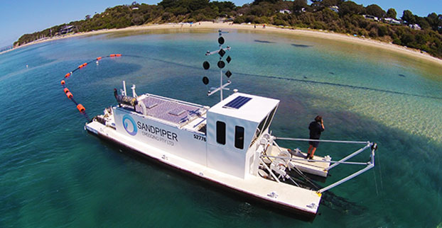
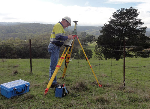
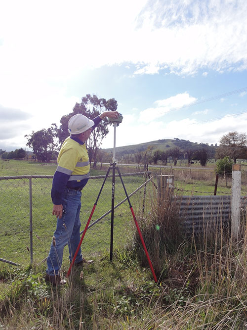
    Over two years, the testbed will validate applications in nine industry sectors: agriculture, aviation, construction, maritime, mining, rail, road, spatial and utilities.

    To improve precision navigation, a second-generation SBAS will use signals from both GPS and Galileo, and dual frequencies, to achieve even greater GNSS integrity and accuracy.
    To improve precision navigation, a second-generation SBAS will use signals from both GPS and Galileo, and dual frequencies, to achieve even greater GNSS integrity and accuracy. (Graphic: Lockheed Martin)

    In January, the Australian Government announced $12 million in funding for the trial of SBAS technology.

    “Many industries rely on GNSS signals for accurate, safe navigation. Users must be confident in the position solutions calculated by GNSS receivers. The term ‘integrity’ defines the confidence in the position solutions provided by GNSS,” says Vince Di Pietro, chief executive of Lockheed Martin Australia and New Zealand. “Industries where safety-of-life navigation is crucial want assured GNSS integrity.”

    Ultimately, the second-generation SBAS testbed will broaden understanding of how this technology can benefit safety, productivity, efficiency and innovation in Australia’s industrial and research sectors, according to Lockheed.

    “We are excited to have an opportunity to work with Geoscience Australia and Australian industry to demonstrate the best possible GNSS performance and proud that Australia will be leading the way to enhance space-based navigation and industry safety,” Di Pietro adds.

    Basic GNSS signals are accurate enough for many civil positioning, navigation and timing users. However, these signals require augmentation to meet higher safety-of-life navigation requirements. The second-generation SBAS will mitigate that issue.

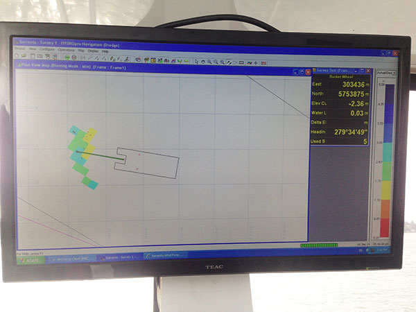
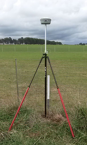
    Once the SBAS testbed is operational, basic GNSS signals will be monitored by widely-distributed reference stations operated by Geoscience Australia. An SBAS testbed master station, installed by teammate GMV of Spain, will collect that reference station data, compute corrections and integrity bounds for each GNSS satellite signal, and generate augmentation messages.

    “A Lockheed Martin uplink antenna at Uralla, New South Wales, will send these augmentation messages to an SBAS payload hosted aboard a geostationary Earth orbit satellite, owned by Inmarsat,” says Rod Drury, director of international strategy and business development for Lockheed Martin Space Systems Co. “This satellite rebroadcasts the augmentation messages containing corrections and integrity data to the end users. The whole process takes less than six seconds.”

    By augmenting signals from multiple GNSS constellations — both Galileo and GPS — second-generation SBAS is not dependent on one GNSS. It will also use signals on two frequencies — the L1 and L5 GPS signals, and their companion E1 and E5a Galileo signals — to provide integrity data and enhanced accuracy for industries that need it.

    Research partners

    Lockheed Martin will provide systems integration expertise in addition to the Uralla radio frequency uplink. GMV-Spain will provide its magicGNSS processors. Inmarsat will provide the navigation payload hosted on the 4F1 geostationary satellite. The Australia and New Zealand Cooperative Research Centre for Spatial Information will coordinate the demonstrator projects that test the SBAS infrastructure.

    Lockheed Martin has significant experience with space-based navigation systems. The company developed and produced 20 GPS IIR and IIR-M satellites. It also maintains the GPS Architecture Evolution Plan ground control system, which operates the entire 31-satellite constellation.

  • Australia to invest $12 million to test SBAS positioning technology

    The Australian Government will invest $12 million in a two-year program looking into the future of positioning technology in Australia.

    The funding includes testing of satellite-based augmentation systems (SBAS) that can offer instant, accurate and reliable positioning technology. The improvements in positioning could provide future safety, productivity, efficiency and environmental benefits across many industries in Australia, including transport, agriculture, construction and resources.

    The two-year project will test SBAS technology that has the potential to improve positioning accuracy in Australia to less than five centimeters. Currently, positioning in Australia is usually accurate to five to 10 meters. While highly accurate positioning technologies are already available in Australia, they are expensive and only available in specific areas and to niche markets.

    Research has shown that the widespread adoption of improved positioning technology has the potential to generate upwards of $73 billion of value to Australia by 2030.

    Federal Minister for Infrastructure and Transport Darren Chester said the program could test the potential of SBAS technology in the four transport sectors — aviation, maritime, rail and road.

    “SBAS utilizes space-based and ground-based infrastructure to improve and augment the accuracy, integrity and availability of basic GNSS signals, such as those currently provided by the USA Global Positioning System (GPS),” Chester said.

    “The future use of SBAS technology was strongly supported by the aviation industry to assist in high accuracy GPS-dependent aircraft navigation. Positioning data can also be used in a range of other transport applications including maritime navigation, automated train management systems and in the future, driverless and connected cars,” he said.

    Minister for Resources and Northern Australia Matt Canavan said access to more accurate data about the Australian landscape would also help unlock the potential of Northern Australia.

    “This technology has potential uses in a range of sectors, including agriculture and mining, which have always played an important role in our economy, and will also be at the heart of future growth in Northern Australia,” Senator Canavan said. “Access to this type of technology can help industry and Government make informed decisions about future investments.”

    The SBAS testbed will use existing national GNSS infrastructure developed by AuScope as part of the National Collaborative Research Infrastructure Strategy. It will test two new satellite positioning technologies — next-generation SBAS and Precise Point Positioning, which provide positioning accuracies of several decimeters and five centimeters respectively.

    The SBAS testbed is Australia’s first step towards joining countries such as the U.S., Russia, India, Japan and many across Europe in investing in SBAS technology and capitalizing on the link between precise positioning, productivity and innovation.

    Early this year, Geoscience Australia with the Collaborative Research Centre for Spatial Information (CRCSI) will call for organizations from a number of industries including agriculture, aviation, construction, mining, maritime, rail, road, spatial and utilities to participate in the testbed.

    For more information about the SBAS testbed and National Positioning Infrastructure Capability visit the Geoscience Australia website.

  • Editor Alan Cameron to speak at IGNSS 2016 in Sydney

    Alan Cameron
    Alan Cameron

    GPS World Editor and Publisher Alan Cameron will deliver the keynote address at IGNSS 2016, which will be held Dec. 6-8 at the Colombo Theatres, UNSW Australia, Sydney. Cameron will speak on “The Future — Navigated Autonomously.”

    The International GNSS Society (IGNSS) hosts the event, which is the Southeast Asian region’s premiere conference on GNSS and related position, navigation and timing (PNT) technologies.

    The conference will bring together leaders in GNSS and PNT to examine the latest technology, present cutting-edge research and discuss in open forums the implications for policy, market development and positioning infrastructure deployment.

    IGNSS 2016 will showcase a number of contemporary topics including, the role of PNT in automated land and aerial vehicles, the growing range of commercial precise positioning services, hard infrastructure issues such as space based augmentation systems, and soft infrastructure issues such as datum modernization and mitigation of system vulnerabilities. These hot topics will be discussed in the context of the latest system developments fueling the multi-GNSS era.

    Topics will include the following:

    • Emerging Application Areas for GNSS
    • Key Industries and their Reliance on GNSS
    • Aviation and Avionics
    • Cooperative Intelligent Transport Systems
    • Maritime Applications
    • Unmanned Aerial Systems
    • Alternatives to GNSS
    • National Positioning Infrastructure
    • Policies and Standards
    • GNSS Augmentation including SBAS
    • Datums and Geodesy
    • National and International GNSS Developments
    • Embracing the Multi-GNSS Era
    • GNSS Receiver Development
    • GNSS Vulnerability
    • Machine Guidance in Agriculture, Construction and Mining

    Learn more at the conference website.

  • Unmanned update: Government and industry join to resolve issues

    Unmanned update: Government and industry join to resolve issues

    The White House has joined in to support continued growth of the emerging unmanned aerial vehicle (UAV) industry. Unmanned aircraft systems (UAS) technologies are powering a revolution in unmanned flight.

    Already used by government, by research organizations, and by industry for more efficient and safe applications, drones are now becoming a developing part of the United States economy. A new initiative by the Office of Science and Technology Policy (OSTP) brought together 150 UAS community leaders for a recent workshop at the White House. The event was held to find out more about the UAS industry, where it’s headed, and to seek ideas for how government might contribute.

    Given that the current administration has only limited time remaining, the group proposed some significant issues that could be launched, or at least where there should be focus. The only short-term goal that could be achieved by the end of the year is the release by the Federal Aviation Administration (FAA) of a Notice of Proposed Rulemaking for UAV operations over people.

    One principle objective should be for the Federal Communications Commission (FCC) to develop rules in concert with industry for licensing allocated frequency spectrum. While the FAA has yet to develop rules for higher altitude, larger-UAV operations, the UAS industry requires spectrum for command and control of aircraft at high altitudes and for beyond visual line of sight operations. The FAA and FCC regulations should be developed in parallel.

    The group felt another problem that should be tackled is UAS Traffic Management (UTM). While NASA has been investigating prototype UTM options and various industry leaders have been advocating a number of different approaches, the group seemed to indicate that unless government took some form of leadership role, a number of different, incompatible solutions might be developed.

    Finally, there was discussion about how a number of states are implementing local UAS regulations, while the FAA believes it has responsibility for all U.S. airspace. However, large numbers of small UAS (sUAS) are expected to operate at lower altitudes, so local authorities believe they should assert more control, even though they were comfortable in the past ceding control of manned aviation to the FAA. However, nationwide, uniform safety regulations appear to be just as critical for UAS as for manned aircraft, which seems to imply that the FAA should lead the effort.

    So, some good issues were identified that need serious work to enable UAS operations, but it’s always a problem when someone else gets stuck with the responsibility to find solutions — which will be the case when the administration changes. Hopefully the new guys will also believe how beneficial UAS will be for the economy and will chase down and help overcome these barriers.

    Package Delivery

    Meanwhile, on the package delivery front, Google’s Project Wing has been approved by FAA to begin testing, albeit within the confines of Northern Plains UAS test site in North Dakota. The heavier Google delivery drones will be tested from the ground up to 29,000 feet with external loads, and efforts will be made to fly them beyond line of sight without chase aircraft. Google will also prototype a low-altitude airspace management system for the tests that uses inexpensive comms and data technologies.

    While authorization in the U.S. was still pending, Google went looking for somewhere to test its prototype drone delivery system, and in August 2014 undertook testing in Queensland, Australia. At that time Google was using a vertical take-off UAV system — they delivered portable radios and water bottles to farmers.

    Google tests delivery drones in Australia.
    Google tests delivery drones in Australia.

    Word is that Google is now looking at fixed-wing UAVs and cargo slung from them — maybe for transporting heavier packages.

    Google’s new delivery drone?
    Google’s new delivery drone?

    And further North in Ontario, Canada, Drone Delivery Canada (DDC) is moving forward with the development and implementation of a commercial drone delivery platform for retailers, service organizations and government agencies. In remote parts of Canada, access to some communities can be difficult to impossible for conventional means. DDC expects to add additional sites later this year for beyond visual line of sight (BVLOS) testing, working with the Canadian government towards obtaining its operator status. DDC also just announced an agreement with a Canadian retailer to test and integrate its drone system with the retailer’s existing depot-to-depot delivery logistics.

    DDC prototype drone delivery system.
    DDC prototype drone delivery system.

    And not to be left out of this picture, 7-Eleven has been working with drone manufacturer Flirtey to test autonomous delivery of convenience store items. Dispatched from a Nevada 7 Eleven store, two deliveries were completed to a local customer’s house using precision GPS, where the Flirtey drone hovered and gently lowered each package of goodies.


    Flirtey drone delivers 7-Eleven goodies.
    Flirtey drone delivers 7-Eleven goodies.

    So, while the White House now seems to be actively engaged in supporting the introduction of UAS into commercial operations in the U.S., we still have many significant obstacles to overcome  not least are access to control frequencies, the development and introduction of drone traffic-control systems, and the coordination of federal and state rule-making. But this apparently has not deterred several organizations, including Google, DDC, Flirtey/7-Eleven, Amazon, Walmart and others, to trial drone package delivery. U.S. states have also recognized the promise of everything connected with UAVs and their operations, and are collaborating with the FAA to establish large swaths of the airspace for UAV testing.

    What with the White House and states already on the UAV bandwagon, surely it won’t be long before we crack the nut and get significant commercial operations approved and underway.

    Tony Murfin
    GNSS Aerospace

  • Papers sought for IGNSS conference in Sydney

    The call for papers is now open for IGNSS 2016, set for Dec. 6-8 in Sydney, Australia. Closing date for abstract submission is July 4; and the final date for the submission of papers requiring peer review is Sept. 26.

    The International GNSS Society (IGNSS) runs the Southeast Asian region’s premier conference on GNSS and related position, navigation and timing (PNT) technologies. It will bring together leaders in GNSS and PNT to examine the latest technology, present cutting-edge research and discuss in open forums the implications for policy, market development and positioning infrastructure deployment.

    IGNSS 2016 will showcase a number of contemporary topics including, the role of PNT in automated land and aerial vehicles, the growing range of commercial precise positioning services, hard infrastructure issues such as space based augmentation systems, and soft infrastructure issues such as datum modernization and mitigation of system vulnerabilities. These hot topics will be discussed in the context of the latest system developments fueling the multi-GNSS era.

    Topics will include the following:

    • Emerging Application Areas for GNSS
    • Key Industries and their Reliance on GNSS
    • Aviation and Avionics
    • Cooperative Intelligent Transport Systems
    • Maritime Applications
    • Unmanned Aerial Systems
    • Alternatives to GNSS
    • National Positioning Infrastructure
    • Policies and Standards
    • GNSS Augmentation including SBAS
    • Datums and Geodesy
    • National and International GNSS Developments
    • Embracing the Multi-GNSS Era
    • GNSS Receiver Development
    • GNSS Vulnerability
    • Machine Guidance in Agriculture, Construction and Mining

    Learn more at the conference website.

  • Australia could replace jet fighters with unmanned combat

    Australian Chief of the Defence Force Mark Binskin said that combat drones could take the place of some Joint Strike Fighters (JSFs).

    A defense white paper states that Australia will buy 72 Joint Strike Fighters to replace current fighter planes “Classic” Hornets, six of which are now flying bombing raids over Iraq and Syria. But it leaves open the possibility of not buying a final squadron of roughly 25 JSFs to make up the 100-strong air combat fleet Australia needs.

    Instead, the white paper states that to replace the newer, current squadron of Super Hornet aircraft from about 2030, alternatives will be “considered.”

    Binskin said the department was keeping an open mind given the rapid improvements in armed drones or unmanned combat aerial vehicles, also known as UCAVs.

  • Australia enacts new GNSS requirements for aviation

    Australia’s Civil Aviation Safety Authority (CASA) has implemented a GNSS equipment mandate for all aircraft flying in the country, regardless of state of registry. The mandate is designed to align Australian operations with global standards set by the International Civil Aviation Organization (ICAO) for Communications, Navigation, Surveillance and Air Traffic Management (CNS/ATM).

    The changes include the requirement that all aircraft operating under instrument flight rules (IFR) must now be equipped with GNSS avionics meeting TSO C129, which enables compliance with Required Navigation Performance (RNP) 1 terminal area and RNP 2 continental en route operations that begin May 26.

    GNSS is the enabling technology for both performance-based navigation (PBN) and automatic dependent surveillance-broadcast (ADS-B) in Australia and will affect all IFR aircraft. Applying both PBN and ADS-B over the whole of Australia will permit:

    • Increased safety as air traffic control surveillance will be available over the whole of Australia at higher levels, and with substantial coverage at lower levels.
    • Flexi-route—a system that optimizes aircraft routes according to the latest weather and location of other aircraft
    • Reduced separation distances, greater fuel efficiency, lower flight times and reduced congestion at busy aerodromes.

    To help foreign-registered aircraft operators in meeting the new requirements, transition arrangements are available for a two-year period. Operators who need the extension must complete an online form before their first flight in Australia on or after May 26.

    To facilitate RNP operations within Australia, CASA has developed an acceptable means of compliance document.

    The GNSS mandate will see ground-based navigation capability reduced by about 50 percent, with the decommissioning of about 190 ground-based navaids. The remaining network of navaids will form the GNSS backup navigation network.

  • Dredging replenishes Australia’s Sorrento Beach

    Dredging replenishes Australia’s Sorrento Beach

    Shifting sands in Australia’s Port Phillip Bay left a popular beach without enough sand this past holiday season. As summer approached, the Mornington Peninsula Shire and Australian Department of Environment and Primary Industries (DEPI) decided to replenish Sorrento beach by dredging a nearby sandbank.

    DEPI awarded the contract to Sandpiper Dredging because of its history of minimizing environmental impact. Sandpiper has a decade of dredging experience and builds its own precision dredgers in Tweed Heads, New South Wales.

    Sandpiper-2-Sorrento-W
    Erosion of Sorrento Beach required high-tech repairs. (Photo: Trimble)

    The contract specified the dredge ground extent and the minimum Australian Height Datum (AHD) height Sandpiper could dredge. To obtain precise 3D positions from the GPS receiver, GPS corrections were streamed in via cellular Internet from the Victorian government’s Continually Operating Reference System (CORS). Position and heading from the SPS461 receiver were interfaced into construction software to display dredge position. The inclinometer mounted on the dredge frame also interfaced with the software and allowed the AHD height of the cutter head to be displayed.

    The dredge position displayed in the software allowed operators to stay within the dredge grounds and ensure no over-dredging occurred. The software was the central hub in the wheelhouse displaying and logging dredge positions and the AHD height of the dredge head.

    Machine-control positioning enabled Sandpiper to precisely place in 3D the cutter suction head on the dredge frame in real time.
    Machine-control positioning enabled Sandpiper to precisely place in 3D the cutter suction head on the dredge frame in real time. (Photo: Trimble)

    The software also allowed the dredge operator to focus on controlling the dredge rather than trying to determine where to dredge. Using GPS and AUSGeoid09 removed the need for considering tide data because the software displayed the AHD height. The logged data could be delivered to the client as an as-built drawing.

    The beach was replenished within budget and on time for the holiday season, and the community is now enjoying the restored beach.

    Hydrographic Tech

    To achieve the job specifications and efficient operation of their dredge, Sandpiper needed hydrographic survey technology on board. SITECH Construction Systems, a Trimble distributor, provided the company with:

    • Trimble SPS461 GPS heading and positioning receiver
    • Inclinometer to measure the angle of the cutter head frame
    • Trimble HYDROpro dredge software to display and log seabed levels. The software can be configured for a wide range of dredgers.

    “After speaking about the challenges we had been facing, SITECH came back with the solution of the Trimble HYDROpro system, which meant we could dredge in exactly the right place and maintain coverage, all the while protecting the environment of the beach,” said Daniel Fristch, owner of Sandpiper.

    Sandpiper-3-Sorrento-W
    HYDROPro at work on the Sorrento Beach project. (Photo Trimble)
  • High Above Down Under: Database Offers 3D Elevation Model of the Globe

    High Above Down Under: Database Offers 3D Elevation Model of the Globe

    worlddem_aus_wipena-pound_2014-W
    (WorldDEM image courtesy of Airbus Space & Defence)

    Wilpena Pound, shown above, is a natural amphitheater of mountains in the heart of Flinders Ranges National Park in South Australia. Wilpena Pound is 17 kilometers long and 8 kilometers wide, covering an area of 100 kilometers. The highest peak is St. Mary Peak, at 1,170 meters.

    The WorldDEM Digital Elevation Model of the Pound is based on data acquired by the German high-resolution radar satellites TerraSAR-X and TanDEM-X, which started synchronous data acquisition in December 2010 and completed coverage of the Earth’s entire landmass twice over in mid-2013. The satellites covered more complex terrain areas with a third and fourth acquisition campaign to ensure accuracy for the WorldDEM mapping database, a 3D global pole-to-pole digital elevation model distributed by Airbus Defence and Space.

    Since its commercial launch in April 2014, WorldDEM has provided high-precision elevation models to a wide variety of industries. Mining studies in equatorial regions use it to analyze dense vegetation. It’s used for infrastructure corridor design and costing. Military and civil aviation use it for low-altitude flight path and landing-area planning for helicopters and aircraft in remote and difficult to access areas.

    The database now covers large parts of North and South America, Western and Southern Africa, the Middle East, Australia, Northern Europe and Asia. The most recent additions include complete coverage of Scandinavia, Ukraine, Iran, Iraq, Angola and Saudi Arabia. In all, 80 million km² of WorldDEM data has been captured.

    Check what areas are available.

  • FOIF GNSS Receivers Aid with Australian Pipeline Survey

    Photo: FOIF GNSS Receivers

    Three years ago, engineering survey company G & C Sadlier Design was engaged to perform a route selection and centerline pegging survey for a gas pipeline duplication between Somerton in Victoria and Young in New South Wales, Australia. To accomplish the work, G & C Sadlier Design turned to FOIF GNSS receivers.

    So far, about 225 kilometers have been surveyed and constructed, with 306 kilometers still to be surveyed, designed and built, according to surveyor Greg Sadlier. The current focus is a 100-kilometer section in Victoria and a 70-kilometer section in New South Wales. Recently completed are two linear static control surveys over 80 kilometers in Northern Victoria and 70 kilometers at the end of the project near Young in New South Wales.

    Photo: FOIF GNSS Receivers

    “These surveys have been done using a FOIF F60 Base GNSS receiver and two FOIF A30 Rover receivers. (Two one-man survey crews are used),” Sadlier said. The procedure is to set up the F60 base over a point with known coordinates and elevation, approximately in the center of the alignment to be surveyed.

    The base was set first, to record 1-second data to the datacard over the duration of the survey. One surveyor started the base, and surveyed forward to the end of the alignment, and the other rover crew started at the beginning of the alignment and surveyed towards the base. The rovers were also set to record 1 second data to the datacard.

    “The control points were 0.75-m steel star pickets driven flush with the ground surface, and witnessed with a galvanized 1.5-m steel star picket,” Sadlier explained. “Each rover point was surveyed for 20 minutes plus 1 minute per kilometer of the distance to the base. That is, a point that is 35 Km from the base will be occupied for 55 minutes or 3300 epochs. With the control points at easy accessed positions, usually roads crossing the alignment, at intervals of about 8 kilometres mean that the survey of 80 Km is completed in one day.

    Photo: FOIF GNSS Receivers “We have found the FOIF GNSS receivers are very easy to use, and the epoch readout on screen is very reassuring that the data is being stored, and easily confirms that the correct amount has been stored. The data is easily downloaded from the card and converted to Rinex format with FOIF RnxTransform. The data was post processed by a third party.”

    The control survey results were adjusted (Helmert adjustment) onto check Permanent Marks at both ends. “This made a rotation of 0°00’00.001” and a shift of 0.007 meters E and 0.005 meter N. An elevation difference of .035 meters was manually adjusted out over the 80 kilometers,” Sadlier said.

    “We are now using the control survey while surveying the route selection and features survey,” Sadlier said. “We have two RTK base locations at the 25-kilometer mark and 52-kilometer marks, and using our VHF radio solution have coverage over the entire job with a 10-kilometer overlap in the center.

    “We have found that RTK observed control readings of 180 epochs return residuals of less than 010 meters for both coordinate and elevation for all the static control points. Very impressive results considering the length of the survey,” Sadlier said.

    The engineering firm has yet to process the New South Wales data, but expects the same or better, Sadlier said, as the overall length is a little less and the surveyed control points were in more open country with less tree cover.


  • Tallysman GPS/GNSS Antennas Available in Australia, New Zealand

    Tallysman GPS/GNSS Antennas Available in Australia, New Zealand

    TW4421 wideband dual-feed GPS/GLONASS antenna.
    TW4421 wideband dual-feed GPS/GLONASS antenna.

    Two dual-feed GPS/GLONASS antennas from Tallysman’s GNSS antenna range are now available in Australia and New Zealand through M2M Connectivity. Tallysman is a Canada-based developer of high-performance GNSS antennas focused on the requirements for precision and multi-constellation GNSS receivers.

    Featuring a dual-feed wide-band patch element, Tallysman’s TW2410 and TW4421 antennas cover the GPS L1, GLONASS G1 and SBAS (WAAS, EGNOS and MSAS) frequency band (1574 to 1606 MHz). The dual-feed patch provides excellent circular polarized signal reception, multipath rejection and out-of-band signal rejection, according to Tallysman.

    Offering tight phase center variation (PCV), the antennas are suitable for high-accuracy applications and for use in precise point positioning (PPP) systems that require only a single frequency such as single-frequency RTK solutions, GNSS compasses and machine control.

    Suitable for precision industrial, agricultural and military applications, the dual-feed GPS/GLONASS antennas feature Tallysman’s Accutenna technology that provides superior or multipath signal rejection and precision. The TW2410 and TW4421 antennas are housed in IP67 industrial-grade weather-proof, magnet mount enclosures and come with a wide range of connector options and cable lengths.

    Tallysman is a manufacturer of high-performance, high-quality products for a wide range of GNSS applications.

  • Trimble VRS Now Service Now Available in Australia, Oregon

    Trimble VRS Now coverage in Australia.
    Trimble VRS Now coverage in Australia.

    Trimble, together with its distribution partner Ultimate Positioning Group (UPG), announced the availability of Trimble VRS Now correction service in Queensland, New South Wales, South Australia, Tasmania and Victoria.

    Trimble is also now offering the Trimble VRS Now correction service in Oregon’s Willamette Valley.

    The commercial subscription service provides surveyors, civil engineers, geospatial professionals and other industry specialists in these areas with instant access to real-time kinematic (RTK) GNSS corrections without the need for a base station.

    Using both GPS and GLONASS constellations, the Trimble service delivers centimeter-level RTK corrections customized for each GNSS receiver’s location anywhere in the network via cellular communications. The Trimble VRS Now service supplies accurate, reliable and easy-to-use GNSS positioning for a variety of applications including surveying, urban planning, urban and rural construction, environmental monitoring, resource and territory management, disaster prevention and relief and scientific research, Trimble said.

    “The addition of VRS Now to Trimble’s current portfolio of corrections technologies and services in Australia highlights our ability to meet any accuracy, delivery, availability and financial consideration across a variety of applications and markets,” said John Sprivulis, business area director of Trimble’s Positioning Services Division in the Asia Pacific. “Trimble is effectively creating a national positioning infrastructure to meet Australia’s future needs.”

    Trimble VRS Now in Australia is a continuation of Trimble’s focus on providing solutions that enable customers to increase productivity by simplifying access to high-precision accuracy around the world. Similar VRS Now services are operating in parts of the U.S. and Europe.

    In addition, the Australian VRS Now service supports the Trimble Pivot Field Mobile App, which provides up-to-the-minute information on the VRS Now system status for users in the region.

    Because OmniSTAR CORS service in the area is being phased out, existing Australian users will be automatically transitioned to the Trimble VRS Now service, which provides easy access to high accuracy and reliable positioning within the network coverage area.

    Service in Australia and Oregon is a continuation of Trimble’s focus on providing solutions that enable customers to increase productivity by simplifying access to high-precision positioning around the world. Similar VRS Now services are operating in Illinois, Indiana, Iowa, Nebraska, Colorado, Florida, Alabama, Mississippi, Texas, and parts of Europe.