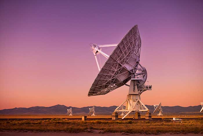
China will lose access to a strategic space tracking station in Western Australia when its contract expires, a decision that could affect BeiDou constellation service in the Pacific region, according to a Reuters report.
A contract between the Swedish Space Corp. (SSC) and China has given Beijing access to a station antenna since 2011, but the SSC satellite station is primarily used by the United States and its agencies.
The Swedish state-owned company told Reuters it wouldn’t enter into any new contracts at the Australian site to support Chinese customers after its current contract expires, but did not disclose the exact date.
Ground stations are a vital part of space programs given they create a telecommunications link with spacecraft. While stations have different capabilities, they can be equipped to coordinate satellites for civil-military GNSS such as Beidou, Russia’s GLONASS, the European Union’s Galileo system, and U.S.-owned GPS.
China’s space program has been increasing its access to overseas ground stations in recent years in line with the expansion of its space exploration and navigational programs.
“Generally speaking, anywhere you put a GNSS monitoring ground station will improve the accuracy of positioning for that region,” said Joon Wayn Cheong, a senior research associate at the University of New South Wales’ School of Electrical Engineering.
China wants to remove its dependence on GPS as part of broader plans to expand its global influence, says Christopher Newman, professor of Space Law and Policy at Northumbria University in Newcastle, England. “GPS could be made unavailable to them in a military conflict. An independent secure system is crucial for the capabilities of the People’s Liberation Army [China’s military] with respect to targeting, weapons, navigation,” he told Reuters.
Beijing last year reestablished diplomatic ties with the small Pacific island nation of Kiribati, where it has a mothballed ground station.
“Seen & Heard” is a monthly feature of GPS World magazine, traveling the world to capture interesting and unusual news stories involving the GNSS/PNT industry.
Photo: Drazen Zigic/iStock/Getty Images/Getty Images Plus
Where’s the Beef?
A new mapping app is helping Los Angeles County residents find more than 2,000 food resources, during and after the COVID-19 pandemic. Sponsored by the non-profit 211 LA County, the LA FoodFinder is powered by Slingshot Earth, which aggregates food resources and service data from multiple public and private sources. The app enables residents to find resources for child nutrition, meal services, groceries/food pantries, senior food needs and government food benefits programs. Since the COVID-19 outbreak, 211 LA County has experienced a 10-fold increase in website traffic for food needs.
Photo: Symbiont/iStock/Getty Images Plus
Use that app in Germany? No Waze!
The German government has amended its road traffic regulations to outlaw apps that alert drivers to speed cameras. The law makes it clear that any app used for traffic-monitoring alerts is forbidden, whether it runs on a phone, tablet or a GPS navigation system. Violating the traffic laws and using speed camera apps inside a car could result in a fine of up to €75 (about $83). Both Garmin and TomTom have emailed registered users alerting them to the news.
Photo: Geoffrey Blewitt/Debra Vigil
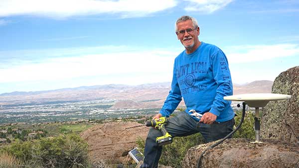
Making the most of GPS data
University of Nevada 2020 Outstanding Researcher Geoffrey Blewitt has made the most of GPS data to study changes in Earth’s crust, from the Ice Age to today. Nevada Today outlines his significant discoveries, including that GPS data may hold a key to detecting dark matter. Other discoveries: Nevada is the fastest growing state, geologically speaking, as it spreads apart. Drought in the western U.S. is causing the Sierra Nevada to lift, and the melting of ice sheets in Greenland is changing the shape of Earth.
Photo: iStock/Getty Images Plus/Getty Images
Koala care
Drones equipped with FLIR thermal-imaging cameras helped save koalas injured in this summer’s Australia bushfires. In a search-and-rescue operation, Victoria wildlife experts and police used DJI Mavic 2 Enterprise Dual drones to scan the forest for injured koalas, many found clinging to scorched eucalyptus trees. The images were relayed to a ground station in a nearby van for closer inspection. When a koala was located, the experts stepped in to assess the animal, and if needed, provide healthcare and relocate it. The team used cherry pickers to retrieve the little animals.
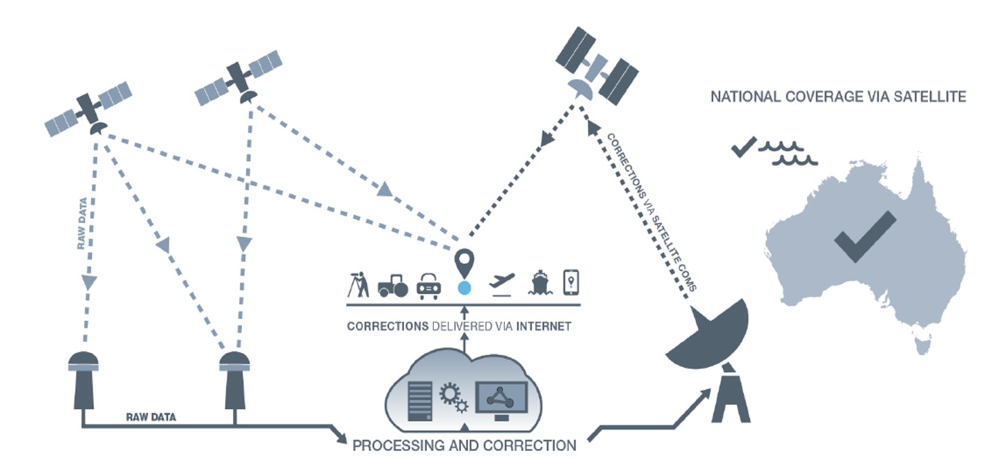
Australia-based Position Partners has launched MiRTK, an open architecture corrections service for GNSS equipment.
Internet-enabled, MiRTK offers an alternative to UHF radio correction services for high-accuracy GNSS. Unlike UHF radios, MiRTK is not limited by range from the GNSS base station and does not require line of sight with the survey rover or machine.
MiRTK uses a small modem that slides onto the accessory slot of the tripod and connects to the base station via a single cable.
A subscription service is available in locations with the Telstra network, mainly continental Australia.
MiRTK is designed for accurate GNSS positioning in the construction, mining and geospatial industries. It is compatible with all brands and models of GNSS from manufacturers including Topcon, Trimble, Leica Geosystems, Sokkia, Hemisphere and more.
“Until now, users that rely on high-precision GNSS for applications such as surveying and machine control had no option but to use UHF radios or a network RTK solution,” said Cameron Waters, geospatial business manager at Position Partners.
“Anyone that’s had to rely on UHF radio frequencies will have experienced problems, including interference, range limitations, costly licensing and severe penalties for breaching licensing laws. MiRTK offers an alternative that is refreshingly simple: no repeaters, no line of sight issues and no complex licensing,” he added.
The Galaxy lithium mine in Ravensthorpe, Western Australia. (Photo: jasonbennee/iStock / Getty Images Plus/Getty Images)
Another benefit, according to Waters, is the ability to utilise a single correction protocol across all GNSS equipment on site. This dramatically reduces complexity and potential connectivity issues. “MiRTK uses NTRIP and a user selectable format such as RTCM3 or CMR, that can be used universally regardless of the brand or model of equipment,” he said. “Users enjoy full speed, full constellation connectivity without the complex radio settings, baud rates, bandwidth or scrambling problems that you get when trying to utilize different GNSS systems with UHF radios.”
To set up the unit, users simply connect the modem to the base station, power the modem on and MiRTK will work for up to 20 hours continuously without charge. Each unit can connect with up to 10 devices such as survey rovers or machine systems as standard, with unlimited potential to scale up connections as required.
“The future of UHF is limited with lower bandwidth, higher density areas, increased governance, rising costs and little flexibility,” Waters said. “MiRTK gives customers a new approach to receive reliable correction data in a simple and hassle-free way, whilst utilizing their existing GNSS hardware.”
Geoscience Australia is seeking a prime contractor for a new satellite-based augmentation system (SBAS) that Australia and New Zealand have committed to implement.
The SBAS will improve position, navigation and timing (PNT) capabilities to end-users in Australia and New Zealand.
The system, which will be called the Southern Positioning Augmentation Network, will augment standard positioning capability provided by GPS and Galileo across all of Australia and New Zealand, with expected user applications in agriculture, construction, resources, utilities and other industries; with decimeter accuracy.
It will also support the aviation and road transport sectors, which have requirements for high-integrity positioning data with sub-meter level accuracy, Geoscience Australia said.
Full operational capability will require a number of satellite payloads in geostationary orbit needed to broadcast data to users. These may be hosted payloads rather than dedicated SBAS satellites, Geoscience Australia added.
This procurement process is administered by Geoscience Australia and is undertaken for the benefit of Geoscience Australia and its New Zealand counterpart, Land Information New Zealand.
Australia and New Zealand are partnering to roll out satellite technology that will be able to pinpoint a location on Earth to within 10 centimeters, unlocking more than $7.5 billion in benefits for industries in both countries.
Prime Minister Scott Morrison and New Zealand’s Prime Minister Jacinda Ardern committed jointly to implement a satellite-based augmentation system (SBAS), to operate across Australia and New Zealand, at the Australia-New Zealand leaders’ meeting held Feb. 28.
The system will improve the accuracy of GPS and other positioning services from the current five to 10 meters to as little as 10 centimeters across Australia and New Zealand without the need for mobile or internet coverage.
The new project follows 18 months of successful trials that tested 27 projects across a range of industries. It will be delivered by Geoscience Australia and Land Information New Zealand under the joint science research and innovation treaty.
Minister for Resources, Water and Northern Australia Keith Pitt said the project, to be operating by 2023, will have significant benefits to a range of industry sectors including mining, agriculture and transport.
“We welcome New Zealand’s commitment to join Australia in rolling out this exciting new technology, which will deliver substantial economic benefits for both countries,” Minister Pitt said.
“An independent analysis by Ernst and Young (EY) has found improved positioning technology will deliver more than $6.2 billion in benefits for Australia, and more than $1.4 billion in benefits for New Zealand, over the next 30 years.
“Trial projects have also found the system can make our roads and rail systems much safer, and can improve the way farmers manage their land, crops and livestock. For the resources sector, the technology can track vehicles and improve site surveys to enable precise extraction of deposits.”
Industry, Science and Technology Minister Karen Andrews said the project will complement Australia’s other investments in space to drive economic growth and create new jobs.
“The Morrison Government is backing these types of technologies because of the positive impact they have on the lives of everyday Australians — from the discoveries that make life easier through to growing industries that create high-value jobs,” Minister Andrews said.
“Many industries stand to benefit from this technology. It could help improve safety and efficiency in aviation and shipping and will be crucial to the development of autonomous vehicles.
“This work also supports our government’s broader commitment to triple the size of the space sector to $12 billion and an extra 20,000 new jobs by 2030.”
The months-long wildfires raging in Australia have killed at least 25 people. Millions — possibly 1 billion — animals have died. More than 2,000 houses have been destroyed. Around 150 fires are still burning in New South Wales and Queensland, with hot and dry conditions accompanied by strong winds fueling to the fires’ spread.
With this conflagration rocking the continent down under, satellite imagery has become important to understanding the scope of the disaster. Here are some of the recent captures.
As seen from the ISS
“Talking to my crew mates, we realized that none of us had ever seen fires at such terrifying scale,” European Space Agency astronaut Luca Parmitano tweeted on Monday, sharing photos taken from the International Space Station.
The astronaut posted images showing what he described as “an immense ash cloud” captured at the time the ISS was flying toward sunset.
An immense ash cloud covers Australia as we fly toward the sunset.
Another social media image, shared widely, was interpreted as a map showing the live extent of fire spread, with large sections of the populous eastern coastline molten red. Because of widespread misinterpretation, the original poster then explained that the image was a 3D visualization and not a photograph of Australia, and showed some areas where fires have been extinguished.
NASA and the U.S. Geological Survey’s Landsat 8 satellite imagery from Jan. 9 shows Kangaroo Island, home to nature reserves. The images were taken using the Operational Land Imager (OLI) on Landsat 8. Using natural-color observations, the images show burned land and thick smoke covering the island, of which at least 156,000 hectares have burned.
Photo: NASA/USGS
The U.S. National Oceanic and Atmospheric Administration (NOAA) satellites are also capturing images, including the resulting plumes of smoke.
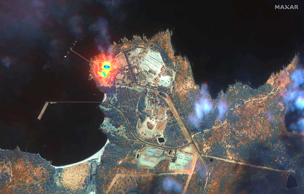
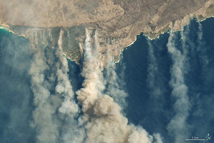
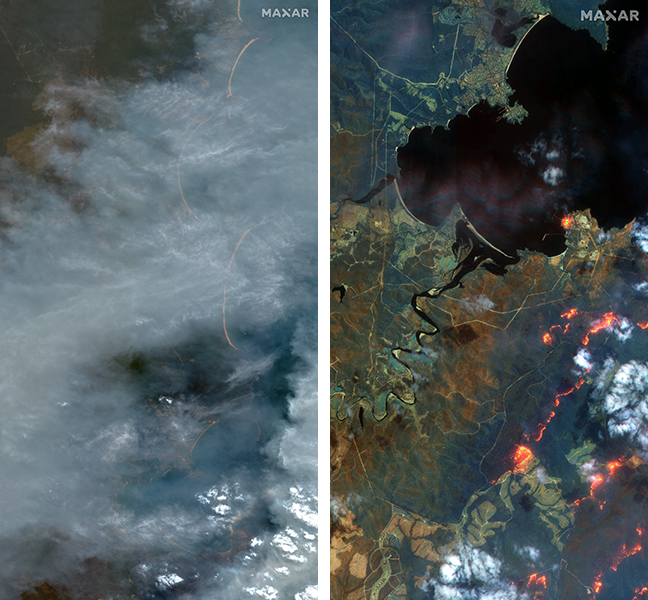
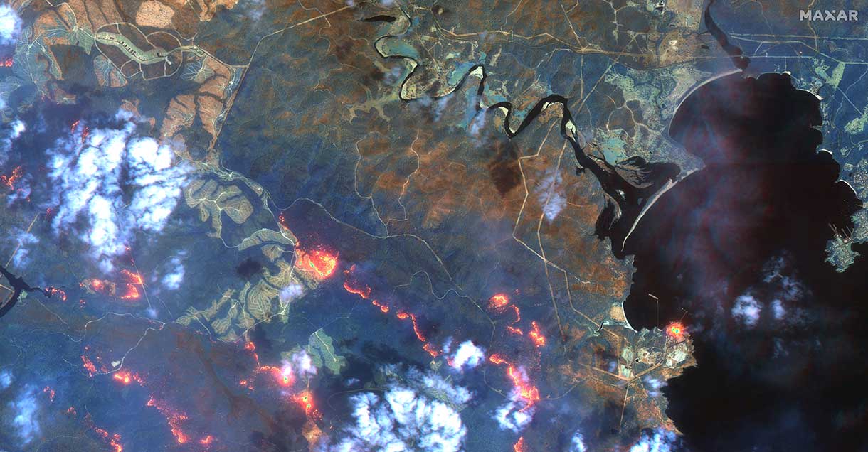
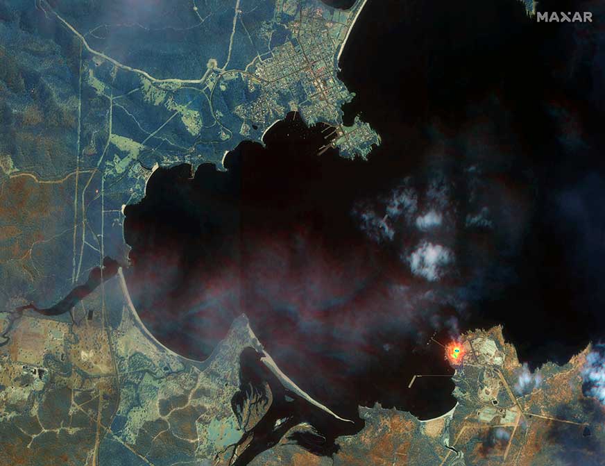
Maxar collected satellite imagery Jan. 12 of the wildfires in New South Wales (NSW). The imagery shown below focuses on the area near the town of Eden, and demonstrates the value of the shortwave infrared (SWIR) sensor.
In an image taken with Maxar’s normal RGB color imagery, the smoky air prevents a clear view of the fires and the hot spots. With Maxar’s WorldView-3 satellite, however, the team is able to penetrate through the smoke using its SWIR sensor for a detailed look at the fire lines and burned vegetation.
With SWIR imagery, burning areas are apparent and show up in a glowing orange-red. Healthy vegetation shows up in shades of blue, and burned vegetation appears in shades of brown.
Satellite Photo: :ESA
Copernicus Sentinel-3 imagery
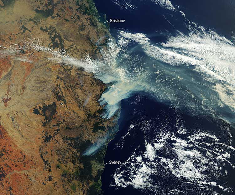
Europe’s Copernicus Sentinel-3 mission has captured the multiple bushfires burning across Australia’s east coast.
In the above image, captured on Nov. 12, 2019, at 23:15 UTC (Nov. 13, 09:15 local time), the fires burning near the coast are visible. Plumes of smoke can be seen drifting east over the Tasman Sea. Hazardous air quality owing to the smoke haze has reached the cities of Sydney and Brisbane.
Flame retardant was dropped in some of Sydney’s suburbs as bushfires approached the city center, and many residents were evacuated. Firefighters continue to keep the blazes under control.
The Copernicus Emergency Management Service – Mapping was activated to help respond to the fires. The service uses satellite observations to help civil protection authorities and, in cases of disaster, the international humanitarian community, respond to emergencies.
Quantifying and monitoring fires is fundamental for the ongoing study of climate, as they have a significant impact on global atmospheric emissions. Data from the Copernicus Sentinel-3 World Fire Atlas shows that there were almost five times as many wildfires in August 2019 compared to August 2018.
Japan-based Terra Drone’s newest branch, Terra Drone Australia, will focus on the mining, oil and gas, power and forestry sectors.
Terra Drone Corporation, an industrial drone services provider headquartered in Tokyo, has finalized its expansion into the Australian market after completing an equity investment in Australian firm C4D Intel Pty Ltd. As part of the deal, C4D Intel will immediately rebrand to Terra Drone Australia.
The move by Terra Drone is the latest of the company’s investments into drone technology businesses across the globe and demonstrates the Japanese company’s commitment to the Australian market. The terms of the transaction were not disclosed.
Founded in 2016, C4D Intel provides surveying, inspection and 3D modeling services to a diverse client base across mining, oil and gas, power and forestry industries in Western Australia.
The company specializes in large-scale unmanned aerial surveys, confined space infrastructure inspections, high-altitude inspections, bridge and pipeline inspections, and asset 3D modeling.
As Terra Drone Australia, the company will be able to leverage the additional growth capital to expand its service offering to include unmanned airborne lidar, bring innovative Terra Group technologies to Australia, and expand its operations to the East coast of Australia, Terra Drone stated in a press release.
The Australian drone service provider’s existing clients include mining companies Rio Tinto and Fortescue Metals Group, and large utilities such as ATCO Gas Australia and Synergy.
“We are delighted to join the No.1 industrial drone services company in the world, Terra Drone. When the world’s fastest-growing drone business chooses to expand to Australia, and selects our business to invest in, it speaks volumes about the opportunities available here and the vision we have for the company,” C4D Intel Operations Manager Will Wishart said.
“There are many advantages of being a part of a global organization and this next phase of growth makes for very exciting times. We have already leveraged Terra Drone’s international network to bring new technology to Australia and look forward to accelerating this as we expand our operations across the Australian continent.”
Terra Drone Corporation CEO Toru Tokushige added, “The establishment of Terra Drone Australia is another milestone for our international expansion strategy. Australia bears a strategic significance in our growth plans. Having a local presence in the region allows us to be close to our customers and strengthen our support to them.”
Later this month, Terra Drone Australia will bring innovative drone technology from The Netherlands to Australia for proof-of-concept trials for global mining company Rio Tinto. The Terra UT Drone from Terra Inspectioneering will allow Terra Drone Australia to offer ultrasonic thickness testing of steel in hard to reach places, such as bin walls which are subject to wear.
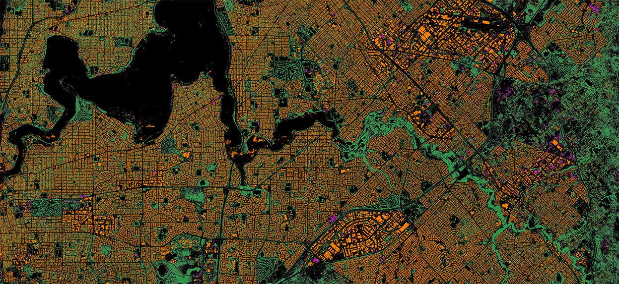
Aerial imagery business Nearmap has launched its new 3D product to streamline the way industries such as urban planning, architecture, construction, government and councils view and shape cities across Australia and the U.S.
The company is also previewing its groundbreaking artificial intelligence (AI) technology at its customer event Navig8.
Nearmap 3D allows customers to stream and export 3D imagery on demand at massive scale through its proprietary MapBrowser web application. Because the imagery is updated frequently, businesses can work with the most current information to make more informed decisions.
Nearmap’s new AI technology is turning millions of aerial images — captured over a decade and multiple times a year — into valuable datasets. The datasets can be used to more accurately and efficiently measure change and quantify attributes, such as solar panels, pools, roofs or construction sites.
Organizations ranging from small businesses to large companies and cities will be able to take advantage of AI-driven location intelligence.
“Product innovation is in our DNA. Everything we do has the customer at the core,” said Tony Agresta, executive vice president of product at Nearmap. “Our customers’ worlds are evolving every day. We need to keep innovating to continue to give our customers a competitive advantage through technology breakthroughs like the ones we are sharing today at Navig8.
“Nearmap 3D is the result of a significant investment in R&D, but also listening to our customers and what they need to transform the way they work,” Agresta said. “Accessing 3D imagery up to now has typically been an arduous, time-consuming and expensive process — but not anymore. This represents the single largest, most frequently updated footprint of 3D accessible through a browser. The ability to measure in 3D space, size up an area and then export Nearmap 3D for use in other platforms will transform the aerial imagery market.
“The AI technology that we’re working on will allow organizations to identify locations with specific attributes and in so doing, reduce site visits, generate more leads, and eliminate the time involved to inspect properties manually. Nearmap AI does the heavy lifting so you don’t have to,” Agresta said.
Composite aerial image of Perth, Australia. (Image: Nearmap)
Instant access to 3D through MapBrowser
Nearmap is making 3D imagery accessible to anyone, in the same way it has with 2-D. While Nearmap has offered 3D imagery since 2017, this new iteration of the technology allows users to instantly stream 3D content at massive scale via its MapBrowser web application.
The lightweight platform offers customers an immersive 3D experience, allowing them to visualize cities in 3D from any direction, measure distances, and immediately export a custom area in a variety of 3D formats at unprecedented speed — the download time is a matter of minutes for most requirements and only a few hours for very large footprints.
“It’s like switching from DVDs to streaming services,” said Tom Celinski, executive vice president of technology and engineering at Nearmap. “Our camera technologies have been capturing 3D since 2017, but now our secret sauce is bringing it onto MapBrowser, allowing users to easily and instantly stream this content with many export options. Now users can visualize, measure, define a custom area, export our 3D and use it in their workflows with other commercial platforms and tools. We’re helping 3D experts and novices alike access reality like never before, and this is an important next step in our Reality as a Service journey.”
Nearmap 3D comes with an extensive library, covering more than 400,000 square kilometers. It is updated once a year and covers major urban areas in Australia and the U.S.
“We live in a 3D world, we think in 3D, and so we have to ensure that our products give the closest representation of reality as possible,” Celinski said. “That means businesses that rely on visualizing 3D content, like architects, for example, can now access up-to-date 3D models instantly and export them in just minutes. In a tender process, for example, that can be the difference between winning a new project or not. The opportunities for Nearmap 3D are endless.”
3D image of Manhattan. (Photo: Nearmap)
A living data set
Nearmap AI technology is the result of more than two years’ worth of research and development, and a team of close to 20 data scientists and machine learning engineers. The team, led by Dr. Michael Bewley, is using the petabytes of imagery that the business has captured over the past 10 years and turning it into a living dataset to accurately identify changes or quantify attributes from the Nearmap library of aerial imagery.
Nearmap has built highly accurate machine learning models and deployed them on a massive scale. The automated process, and the constantly learning engine, means that the AI technology can be applied to any new geography. Nearmap also applies the models to new surveys, generating fresh results with current imagery.
To date, Nearmap has performed analysis on over 1 million square kilometers of imagery across Australia and the U.S. (which constitutes about 80 million properties) and is performing more analysis every day. Nearmap is now inviting customers to take part in a beta program to experiment with various use cases.
“We don’t prescribe how our technologies or content can be used by our customers,” said Michael Bewley, director of AI systems at Nearmap. “Our solar customers could use the AI technology to easily identify where and when solar panels have been installed for maintenance jobs, to prospect new clients in an area where solar energy’s popularity is on the rise; or a government entity that previously had the arduous task of tracking swimming pools or construction in their jurisdictions will be able to do it automatically.”
“But this is the tip of the iceberg — we’re just getting started. This technology is going to profoundly change the way that cities are built,” Bewley said. “Our plans include delivering AI results in many forms, much the same way we deliver our imagery today.”
Both technologies will be presented at Nearmap’s flagship event, Navig8, in Perth on June 6, Melbourne on June 11 and Sydney on June 13.
DroneGun, part of the DroneShield anti-UAV system. (Photo: DroneShield)
DroneShield Ltd. and Collins Aerospace Systems, a unit of United Technologies, have entered a Memorandum of Understanding (MOU) to collaborate on opportunities with the Australian military, as well as globally.
The intent is to add DroneShield’s counter-drone capabilities to Collins’ surveillance systems that its customers are already using.
Collins Aerospace is a supplier of aerospace and defense products. In Australia, it holds current contracts within the Australian Defence Force.
DroneShield is a public Australian company whose products include a suite of counter-drone technologies capable of protecting bases and forward-deployed groups against enemy drone threats.
DroneShield’s products include DroneSentinel (a sensor fusion, multi-method drone detection system), DroneSentry (a combined detection and interdiction system), DroneGun Tactical (a handheld rifle-shaped drone-mitigation device) and RfPatrol (a body-worn drone detection device).
DroneShield Chief Executive Officer Oleg Vornik commented, “Collins Aerospace has a leading position in the Australian defence market and we’re pleased to work together on opportunities that complement our capabilities to enhance customer value.”
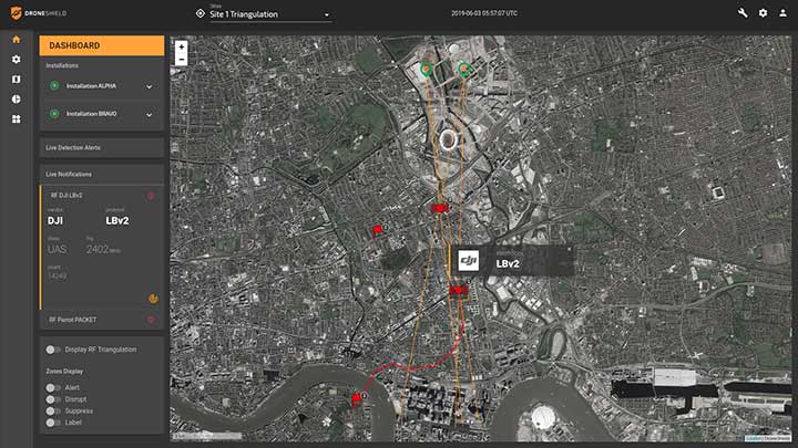
Updated Software. DroneShield has begun the rollout of firmware version 1.1 of its DroneShieldComplete software for its DroneSentinel and DroneSentry counter-drone systems.
Enhancements include a number of features, such as pinpointing locations of pilots of detected drones. This allows for additional counterdrone procedures by customers, such as apprehending the pilots instead of neutralizing the drones directly.
This is expected to be of a substantial benefit for customers who are not legally able to deploy drone countermeasures, as well as enabling them to deal with the cause of the drone-related issues.
DroneShieldComplete 1.1 firmware, showing pilot detection capability with flags. (Photo: DroneShield Ltd.)
“The addition of the capability to locate and apprehend drone pilots without the need for taking down the drone has been developed in response to significant customer demand, and we expect this feature to be utilised by a number of our customers,” Vernik said.
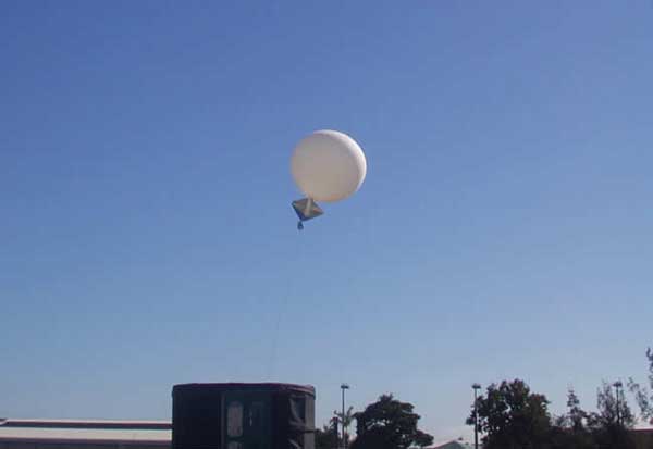
Launch of a weather balloon in Australia. (Photo: Townsville Meteorological Office/Bureau of Meteorology)
The GPS Week Number Rollover, which took place April 6, has grounded the Australian Bureau of Meteorology’s (BOM) weather balloons.
The fault was caused by the rollover of the time stamp in GPS signals, reports ABC news, which caused a “technical fault with the equipment’s communications systems.”
The weather balloons carry a radiosonde that includes GPS tracking. The radiosondes measure various atmospheric parameters and transmits them by radio to a ground receiver.
BOM said its equipment supplier advised the bureau of the fault after the rollover on April 7, and balloon launches ceased on April 8.
GPS clocks returned to zero early on Sunday morning.
Usually, BOM launches 56 weather balloons each day from 38 locations to provide vital information to help meet international obligations under the Convention of the World Meteorological Organization.
Boeing aircraft affected
Also affected by the rollover were some Boeing aircraft. The GPS clock rollover caused “a limited number of 787 airplanes” to display the wrong date, according to Boeing, causing them to be temporarily grounded in China.
Other reports are that at least one KLM 777 flight and a large number of China Airlines 777 and 787 aircraft were grounded due to the issues, while technicians updated the software. A Shanghai Airlines 787 was also reportedly affected.
In all the reported cases so far, the GPS systems were supplied by Honeywell, which issued a service update on the issue.
Orolia’s LEOSAR-GEOSAR-MEOSAR (LGM) Mission Control Center (MCC) solutions are now commissioned as Nodal MCCs in Spain and Australia, enabling global distribution of critical search-and-rescue information through the Cospas-Sarsat system.
With the successful commissioning of their Nodal MCCs, Spain and Australia will now be able to share critical information with the U.S. and France, providing worldwide coverage for global search and rescue.
In addition, since they will be authorized to commission other MCCs in their regions, they will also significantly advance the Cospas-Sarsat MEOSAR program.
Orolia’s McMurdo PRISMA MCC features satellite search-and-rescue technology with full LGM capability. It is the commercial solution of choice for search-and-rescue authorities in Norway, the UK and many other countries.
“We’re proud to support the world’s most critical search and rescue operations,” said Steve Ludwig, Orolia’s director of SARSAT Operations. “With Orolia onboard, you can rely on proven solutions in critical environments where failure is not an option. Our PRISMA Mission Control Center systems are the only successfully deployed, Cospas-Sarsat commissioned commercial solutions available, meeting the highest standard for search-and-rescue support.”
The Orolia PRISMA Mission Control Center. (Photo: Orolia)
Orolia has been developing global search-and-rescue programs for nearly 30 years, reaching a major milestone with the Medium-altitude Earth Orbit Search and Rescue (MEOSAR) system in 2011, and completing all global MEOSAR system installations since.
To date, 75 percent of the Earth’s surface is monitored by Orolia’s MEOSAR systems.
Through its McMurdo brand, Orolia has equipped these systems with the latest search-and-rescue technology to increase response times and save more lives worldwide.
A University of Queensland, Australia, environmental project fused data from terrestrial and UAV lidar collections to estimate forest biomass.
Forest ecosystems contain more biomass than any other ecosystem. Estimating biomass — a critical endeavor to detect the health of ecosystems — can be difficult. Traditional methods can be destructive, such as harvesting trees to measure the weight of the different components.
“We know that forest ecosystems contain more carbon biomass than any other above-ground ecosystem on the planet,” said Kim Calders, Ghent University, on the TERN website. TERN is Australia’s land ecosystem observatory, under the University of Queensland.
It’s estimated that Australian forests store about 10 billion tonnes of carbon, but calculating an exact figure without cutting down trees is difficult. “Traditional methods of estimating aboveground biomass are based on volumes calculated from cut trees and expensive field measurements of tree diameter and height,” Calders said.
Enter 3D-FOREST
The three-year 3D-FOREST project is funded by the Belgian Federal Science Policy Office led by Calders and Hans Verbeeck from Ghent University, partnering with Harm Bartholomeus and Martin Herold from Wageningen University.
Tracking progress towards meeting major global environmental agreements and targets, such as the United Nations’ Sustainable Development Goals and The Paris Agreement, require detailed accounts of carbon stocks and how they’re changing over time.
To meet this need, the 3D-FOREST project is developing new on-ground remote sensing techniques to measure biomass and forest structure and validate global-scale satellite measurements.
“The concept of the project is to capture data to create ‘virtual forests’ with high level detail,” Calders said. “The combination of ‘bottom-up’ terrestrial laser scanning (TLS) and ‘top-down’ UAV lidar data improves biomass estimates and knowledge on how we can upscale plot-based measurements to the landscape level.”
Harvesting virtual forests
Representatives of the 3D-FOREST team undertook terrestrial laser scanning and UAV lidar data collection at three TERN sites: the TERN Litchfield Savanna SuperSite in the Northern Territory; the TERN Robson Creek SuperSite and the affiliate TERN Daintree Rainforest SuperSite in Queensland.
Back in the lab, virtual 3D forests created from the lidar data are then ‘virtually harvested’. Quantitative structure models (QSM) digitally weigh individual trees by calculating their volume and converting this to carbon mass.
“These 3D structural metrics and biomass estimates allow us to scale-up the spatial patterns of tree structure and evenness from the 1-hectare plot scale to entire forests,” Calders said. “This information is crucial for more efficient forest management, but also for better understanding of the spatial variation of forest structure in ecosystem models.”
Scaling up to global carbon budgets
As Europe’s, America’s and India’s space agencies get ready to launch satellites to measure and map the planet’s forests in high-resolution 3D, the value of on-ground and UAV lidar data collected by Calders’ team at TERN sites is even more apparent.
The data from 3D-FOREST will be used to calibrate, validate and improve the accuracy of global bio-geophysical satellite data delivered by space missions including the European Space Agency’s BIOMASS, NASA’s GEDI, and the joint Indian Space Research Organisation and NASA NISAR.
“The ability for these space missions to scale-up estimates of forest biomass to the global carbon budget and monitor ecosystem disturbances is dependent on the high-quality ground reference measurements collected at ecosystem research infrastructure sites, including TERN’s,” Calders said. “The emerging methods and technologies for data collection, and the speed of their development, are truly exciting.”
The field campaign was made possible thanks to collaborations with the CSIRO, James Cook University and the Australian Government Department of Environment and Energy.
For more information on the TERN Ecosystem Processes platform, its network of 12 open-access SuperSites and eddy covariance flux towers, and the data they collect, click here or explore the open data via TERN’s Data Discovery Portal.