Tag: autonomous vehicles

  • Expert Advice: Sensor Fusion for Highly Automated Driving

    High-Precision GNSS Needs Help for Continuous Localization Reliability

    By Siamak Akhlaghi

    Automotive safety and comfort functions, known as Advanced Driver Assistance Systems (ADAS), have become an essential part of modern vehicles. These functions assist drivers in the driving process, providing capabilities such as adaptive cruise control or highway driving mode. To achieve a desired level of performance, the position of the vehicle must be known. Precise positioning supports the vehicle’s systems with planning, executing and monitoring of a particular maneuver.

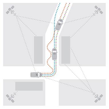
    Position determination, or localization, is the estimation of the location, heading, velocity and acceleration of a vehicle with respect to a fixed coordinate system. High-precision GNSS provides an excellent, worldwide, absolute position reference for localization. However, GNSS technology alone has limitations that must be overcome to make it suitable for use in autonomous systems. For instance, GNSS signals may become blocked or lost due to: obstructions such as in urban canyon or tunnels; multipath, where signals are reflected off the vehicle body; or signal interference from other RF signal sources.

    Siamak Akhlaghi
    Siamak Akhlaghi

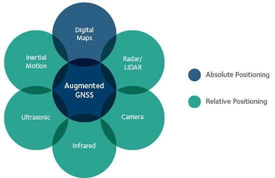
    GNSS correction data and data from other sensors on the vehicle can be used to improve the accuracy and reliability of the vehicle localization solution both globally and with respect to the local environment. To achieve the localization performance, accuracy and integrity required for autonomous vehicles, a multi-system, sensor fusion approach seems to be the most promising. Localization systems will require absolute positioning references like precision GNSS as well as local or relative positioning inputs from inertial sensors, odometers, radar, LiDAR, cameras, infrared and ultrasound sensors. It is clear that no single technology will make highly automated driving possible. Rather, the fusion of the entire vehicle’s sensing technologies will provide the localization accuracy and reliability required.

    Achieving Accuracy and Reliability with GNSS

    GNSS has revolutionized localization in many applications, from precision survey to agricultural guidance. For autonomous driving applications, localization accuracy of 30 centimeters (cm) or less is required. The single-frequency, auto-grade GNSS receivers that have been used in vehicles up to now cannot achieve this level of accuracy. Multi-frequency GNSS receivers utilizing Precise Point Positioning (PPP) correction techniques can achieve accuracies better than 10 cm. PPP algorithms combine GNSS satellite clock and orbit correction data from a global reference station network with high precision GNSS receiver satellite observations to yield robust sub-decimeter positioning without the need for local base stations. Since the PPP corrections can be delivered via satellite, the solution is ideal for highly automated driving where communications infrastructure is costly and in some areas may not be available. Recent advances in PPP techniques provide robust positioning and the ability to quickly regain full accuracy following a temporary loss of GNSS signals, for instance under foliage or highway overpasses.

    Figure 1. High precision / localization with sensor fusion.
    Figure 1. High-precision / localization with sensor fusion.

    Sensor Fusion

    Occasional instantaneous irregularities and temporary outages of GNSS can be compensated for by incorporating measurements of the vehicle motion from inertial sensors mounted in the vehicle. An advantage of a tightly coupled GNSS-inertial solution is that the low frequency errors inherent to inertial sensors can be compensated for and removed from the solution. As a result, sensor fusion algorithms provide a highly robust and stable localization solution at data rates as high as 200 Hz. Other sensors in the vehicle, such as odometers, cameras or LiDAR, can also give information about the relative motion of the vehicle and can add to the redundancy, reliability and stability of the localization solution.

    Figure 2. With a tightly coupled GNSS-inertial solution, low-frequency errors can be removed from the localization solution. The brown dots are the GNSS solution, the blue dots are the inertial solution, and the combined colors represent the tightly coupled solution.
    Figure 2. With a tightly coupled GNSS-inertial solution, low-frequency errors can be removed from the localization solution. The brown dots are the GNSS solution, the blue dots are the inertial solution, and the combined colors represent the tightly coupled solution.

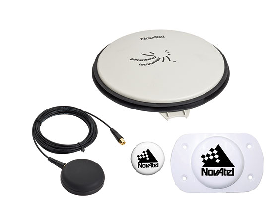
    High-Precision GNSS Antenna

    Antennas play a critical role in achieving precise localization with GNSS. While GNSS antenna requirements differ depending on the application, ideally the antenna should receive only signals above the horizon, have a known and stable phase center that is co-located with the geometrical center of the antenna, and have perfect circular polarization characteristics to maximize the reception of the incoming signals. Highly automated driving applications demand high performance as well as compact size and strong interference rejection. Achieving the required performance amidst these challenging constraints will require innovative new GNSS antenna designs.

    Autonomous driving will be a reality in the not-too-distant future. Innovation in the suite of sensors and fusion algorithms used for solving the localization challenge will be paramount to making safe and reliable autonomous vehicles. Further, innovation developed for automotive autonomy will support new autonomous vehicle applications in other segments.

    High-precision antennas are key.
    High-precision antennas are key.

    Siamak Akhlaghi is segment manager for Autonomous Systems at NovAtel. He has 20 years of professional experience working for high-tech sectors with broad experience in inertial sensors and navigation systems.

  • FAA Grants Topcon UAS Exemption for Sirius

    FAA Grants Topcon UAS Exemption for Sirius

    Sirius-Topcon-UAS-O

    Topcon Positioning Systems has received a national exemption from the Federal Aviation Administration (FAA) that allows for operation of its unmanned aerial system (UAS) in the United States. The exemption covers the operation of the Sirius Basic and Sirius Pro for aerial data collection.

    In early April, the FAA issued 30 more commercial exemptions, bringing the total to 99. That number has since grown to 235.

    The Sirius Pro and Sirius Basic systems are designed to produce accurate solutions for the automated mapping of a wide range of sites — regardless of terrain — including construction sites, mines and quarries. The UAS are designed for land surveying, transmission line and pipeline inspection, and agricultural operations such as field mapping and livestock management. With the Sirius Pro model, Topcon eliminates the need for ground-control points by combining real-time kinematic (RTK) GNSS solutions with precision timing technology to provide accurate mapping results, Topcon said.

    “This exemption is exciting news for the U.S. marketplace,” said Eduardo Falcon, executive vice president and general manager of the Topcon GeoPositioning Solutions Group. “It allows Topcon to be a resource for end-users and provide UAS demonstrations and training. Aerial data collection has a strong impending impact on all the industries we serve, and the possibilities for survey, construction, and agricultural applications are seemingly limitless.

    “Building on the success the Sirius models have already seen in the European and Australian markets, this exemption allows Topcon to expand on that momentum in the U.S.,” Falcon said.

  • J.D. Power: Collision Tops Nav, Paves Way for Autonomous Driving

    Three of the top five technologies consumers most prefer in their next vehicle are related to collision protection, according to a new J.D. Power 2015 U.S. Tech Choice Study.

    Technologies that reduce the overall burden of driving and enhance the safety of the vehicle and its occupants receive the most consumer attention. Among the technologies consumers express most interest in having in their next vehicle are blind spot detection and prevention systems, night vision, and enhanced collision mitigation systems. These findings demonstrate growing customer acceptance towards the concept of the vehicle taking over critical functions such as braking and steering, which are the foundational building blocks leading to the possibility of fully-autonomous driving. The only non-collision protection technologies to crack the top five are camera rearview mirror, which falls into the driving assistance category, and self-healing paint, a comfort and convenience category.

    In contrast, technologies in the navigation category have low preference across all vehicle price segments.

    The inaugural study uses advanced statistical methodologies to measure preference for and perceived value of future and emerging technologies. A total of 59 advanced vehicle features are examined across six major categories: entertainment and connectivity; comfort and convenience; collision protection; driving assistance; navigation; and energy efficiency.

    “There is a tremendous interest in collision protection technologies across all generations, which creates opportunities across the market,” said Kristin Kolodge, executive director of driver interaction and HMI research at J.D. Power. “In contrast, there is very little interest in energy efficiency technologies such as active shutter grille vents and solar glass roofs. Owners aren’t as enthusiastic about having these technologies in their next vehicle because of other efforts automakers are taking to improve fuel economy, as well as relatively low fuel prices at the present time.”

    Chart: J.D. Power

    Gen Y Willing to Spend Most for Technology

    Across all generations, price is the most important consideration for technology, accounting for 25.2 percent of importance. Gen Y is the least sensitive to technology price and shows a greater willingness to spend on new technologies than the other generations. Gen Y consumers, who have accounted for 27.7 percent of new-vehicle sales thus far in 2015 — second only to Boomers at 37.1 percent — are willing to spend an average of $3,703 on technology for their next vehicle. Gen X is willing to spend $3,007, while Boomers, who show the greatest price sensitivity, and Pre-Boomers are willing to spend only $2,416 and $2,067, respectively.

    Chart: J.D. Power

    Importance of Technology

    A certainty in the automotive domain is the impact the consumer electronics world has had upon it. From shifting consumer expectations of user interaction, to the rapid pace of technology introduction and importance of keeping software up to date, to the miniaturization and creation of cost-effective solutions for sensors and cameras, “the auto industry is standing on its head to keep technology up to consumers’ new standards,” said Kolodge. “Those who haven’t done so have seen negative feedback from consumers.”

    Apple CarPlay vs. Google Android Auto

    Smartphones play an increasingly vital role in everyday life, and vehicle technology is beginning to mirror what is offered on those devices, yet Apple CarPlay and Google Android Auto technologies consistently have among the lowest preference scores across all generations.

    Consumer preferences for Apple CarPlay and Android Auto are uniquely dependent on which smartphone they own. Those who currently own a smartphone that is compatible with one of these technologies would choose the technology compatible with their phone at only a moderate rate, while those with the opposite brand of smartphone will rarely, if ever, choose that technology. For example, Android owners indicate that Apple CarPlay is “unacceptable” nearly twice as often as they indicate that solar glass roof is unacceptable.

    Similarly, Apple phone owners indicate that Android Auto is “unacceptable” nearly twice as often as solar glass roof.

    Kolodge noted that “lukewarm interest in these technologies that connect your phone to your vehicle coupled with consumer loyalty to their phone poses a unique challenge for automakers, which could be remedied by knowing their customers’ phone preferences.”

    “Owners of luxury vehicles tend to own iOS devices, 1 so for many luxury brands, offering Apple CarPlay may be the best option, realizing they may be leaving out a portion of the market,” said Kolodge. “For nonluxury vehicle brands, the ownership of Apple and Android devices is much closer to an equal split. The solution for those brands may be to offer both operating systems and allow customers to select the option best suited for them.”

    Key Findings

    • Full self-driving automation technology, part of the collision protection category, is designed to perform all safety-critical driving functions and monitor roadway conditions. The younger generations (Gen Y and Gen X) have substantially higher preference for the technology than the older generations (Boomer and Pre-Boomer). The Pre-Boomer generation, in contrast, has a greater preference for lower levels of automation, such as traffic jam assist.
    • Blind spot detection and prevention has high preference across the range of vehicle price segments. In contrast, reverse auto braking systems have low preference across the vehicle price segments and preference wanes as vehicle prices increase.
    • Advanced sensor technologies, such as hand gesture controlled seats, biometric driver sensors or haptic touch screens have low preference.
    • Technologies in the navigation category have low preference across all vehicle price segments.

    The 2015 U.S. Tech Choice Study was fielded in January through March 2015 and is based on an online survey of more than 5,300 consumers who purchased/leased a new vehicle in the past five years.

  • Exelis Launches Surveillance Tool for UAV Operators

    With Exelis RangeVue, a high-performance GIS visualization engine provides real-time updates of critical operational elements.
    With Exelis RangeVue, a high-performance GIS visualization engine provides real-time updates of critical operational elements.

    Exelis has launched its first airspace situational awareness tool designed specifically for unmanned aerial system (UAS) operations in the United States. Symphony RangeVue puts real-time Federal Aviation Administration (FAA) surveillance data, flexible background maps and weather information in the hands of UAS operators and test range personnel. The system provides significant improvements to the safety and efficiency of UAS operations, whether on the test range or in the field.

    Symphony RangeVue enables UAS operators and test range personnel to have access to both real-time and historical surveillance information via a web-hosted platform, helping to manage mission operations from multiple locations with full visibility of assets. Symphony RangeVue can be used as a command center decision-support and post-event analysis tool, or in the field as a sense-and-avoid addition to UAS ground control stations. Flexible geo-fencing tools alert operators when a UAS approaches airspace boundaries or when other aircraft are in the vicinity.

    “For the first time, UAS operators and test range personnel will have the same situational awareness currently available to general aviation pilots through traffic information broadcast services. This capability is available without having to install avionics surveillance equipment on the UAS aircraft,” said Ed Sayadian, vice president of Civil and Aerospace Solutions for Exelis. “Leveraging the FAA’s own surveillance data combined with advanced sense-and-avoid alerting capabilities, Symphony RangeVue will significantly increase the safety of UAS operations.”

    Symphony RangeVue combines a high-performance visualization engine with the vast network of Exelis NextGen surveillance data, including all of the FAA’s surveillance systems: automatic dependent surveillance-broadcast; en route radar; terminal radar; airport surface detection equipment-X; airport surface surveillance capability; and wide area multilateration. It also integrates locally deployed surveillance assets to deliver hyperlocal situational awareness.

  • Drones Take Off for Location Companies

    Drones Take Off for Location Companies

    3D Robotics Solo Drone with GPS embedded.
    3D Robotics Solo Drone with GPS embedded.

    The National Association of Broadcasters meeting in Las Vegas draws 100,000 attendees annually, making it one of the largest trade shows in the country. However, besides timing and some very niche markets, it has not been a big show for location companies. That is, until now, when NAB welcomed drone manufacturers, all of which embed GPS in their flying aircraft.

    Kevin Dennehy
    Kevin Dennehy

    LAS VEGAS — Commercial drones, a growing market for location companies, was one of the most popular topics at the National Association of Broadcasters Show, held here April 13-16.

    The market for drones has grown nearly five times in the last few years, said Eric Cheng of DJI, which uses GPS in its virtual positioning system that monitors and controls the aircraft. The company markets what they call “flying cameras” that look suspiciously like drones. “The market was initially hobbyists, but now some major broadcast players are buying the cameras,” Cheng said at the Showstoppers trade event the day before NAB.

    Most of the drones offer GPS-based automatic flight stabilization technology. Some even offer a long-range wireless signal and low-latency video transmission.

    Many of the drones are programmed so they don’t go higher than mandated FAA rules or go into restricted, no-fly aviation zones — and all use GPS to do this. Some of the drones even return to the user automatically when their batteries run low.

    DJI drone with embedded GPS.
    DJI drone with embedded GPS.

    DJI offers three cameras for the drones. The high-end Phantom 3 Advanced offers 1080P HD video at 60 frames per second. The 1080P version costs $995.

    In terms of privacy and government regulation, U.S. regulators are way behind Europe, Cheng said. “Other countries are way ahead of the [United States] in terms of working with drone companies,” he said. “In terms of privacy, the step ladder was the first tool for the invasion of privacy. They haven’t outlawed step ladders.”

    The slow U.S. regulatory process has forced some manufacturers to go to other countries to test their drones, said Roger Sollenberger, 3D Robotics’ editorial director. “[U.S. regulations] have moved slowly here — despite the government knowing about worldwide drone rollouts. In Japan, they have been using drones to crop dust for 20 years,” he said.

    Furuno's Don Hanham with GNSS modules at NAB.
    Furuno’s Don Hanham with GNSS modules at NAB.

    To signal increased interest in the commercial drone market, 3D Robotics raised $70 million dollars in funding, led by investor Qualcomm, Sollenberger said. The company, which partnered with action camera giant Go Pro, says its Solo drones can be used not only by broadcast companies, but for railroad track and building inspections.

    As GPS World reported, Furuno Electric Co.’s latest multi-GNSS receiver module, GN-87, has been adopted for the new quadcopter Bebop Drone. The broadcast market has been a good one for company’s timing products, drone integration and even weather prediction, said Don Hanham, a Furuno sales and marketing consultant.

    Furuno is marketing its Doppler Weather Radar System for broadcast. The system allows weather predictors to follow the development of short, localized rainstorms and extreme weather conditions.

    Booz Allen Hamilton Releases Report on 2015 Automaker Priorities

    The era of automotive connectivity, and subsequent heavy competition, is the focus of Booz Allen Hamilton’s new report, “Getting the Customer Experience Right: Auto Industry Priorities in 2015.”

    The company says that automakers should consider six key priorities this year: deliver innovation in months, not model years; differentiate with new partnerships to catch customers’ attention; secure connectivity to reinforce a relationship of trust with customers; address the “so what” of connected cars; personalize the customer experience via the tremendous potential buried in data; and find and build the market for alternative fuel vehicles.

    In terms of big connected vehicle technologies this year, Jon Allen, a principal with Booz, cites 4G pipe in GM and Audi vehicles and over-the-air updates by Ford and BMW, among others. “New parental controls in the Chevy Malibu report average speed and near misses while also preventing drivers from turning on the stereo until seatbelts are fastened. It’s easy to imagine this across vehicles, with parents receiving text messages in real time,” he said.

    Allen said, in terms of vehicle connectivity, automakers must answer the “so what” to set themselves apart from the competition. “We have yet to see the seminal, game-changing connectivity plays. Most companies are still in the ‘features’ mindset, offering new à la carte enhancements,” he said. “They’re not yet articulating a top-down strategy for re-envisioning the customer experience with connectivity.”

    One of the company’s six priorities concerns connected security, which has been a big industry issue since the recent release of the Markey Report, which focused on how vehicles can be hacked. “We have clients who get it.  They’ve identified a senior leader to champion vehicle cyber security and backed them up with a cross-functional team that works closely with counterparts across the organization — in product engineering, supply chain, safety, privacy and IT,” Allen said.  “Other OEMs are still formulating their approach. That said, there are pockets of cyber security across every organization, focused on implementing security controls on individual parts. The challenge is taking the next step —moving from this segmented, ‘assembly line approach’ to a more unified program that focuses on securing the complete vehicle ecosystem.”

    Allen said the company has to speak honestly to customers and regulators about how to manage vehicle cyber security risk. “Industry leaders must prioritize their security approach to ensure that higher risk scenarios are addressed first, rather than try to take on all elements of the challenge at once,” he said.

    Another priority addresses the long lead times, by automakers, to develop and roll out new features, which is a challenge, Allen said. “Consumer electronics, telecommunications and software companies are redefining the traditional industry boundaries that once distinguished them from OEMs. These companies focus on connectivity and services from the start of their product design process,” he said. “The key for automakers going forward is to continue learning from these new competitors, particularly around rethinking the vehicle lifecycle, connected product design, and managing vehicle software updates after purchase. In the near future, automakers will need different approaches to building and enhancing infotainment systems that can keep pace with customer demands.”

    The marriage of autonomy and connectivity is a game-changer, Allen said. “It isn’t just about plugging vehicles in to the Internet of Things. Autonomy transforms transportation,” he said. “When a car drives you, it becomes a retail outlet, a personal assistant, even a trusted chaperone — that all depends on getting both autonomy and connectivity right.”

    The rise of autonomous vehicles gets to the fundamental need for industry leaders to be willing to reimagine their product, Allen said. “Autonomous capabilities are not just about engineering a safer, more efficient, and more appealing mode of transportation. That’s important, but it’s really about a distinctly different product, one that creates a sustained, services-based relationship with the customer,” he said. “It will focus on the driving experience not just behind the wheel, but sitting comfortably inside of a self-driving vehicle. The connected, autonomous vehicle will change automotive for the better — and forever.”

    Allen said his company is seeing OEMs look beyond their individual vehicles to see the emerging connected society that includes ride sharing, multi-modal transportation and connected cities. “The way we go from point A to point B will look and feel drastically different 25 years from now; many OEMs are beginning to accept the change and embrace the challenge,” he said.

  • Furuno Receiver Adopted for Use in Parrot Bebop Drone

    Furuno Receiver Adopted for Use in Parrot Bebop Drone

    Parrot's quadcopter Bebop Drone has Furuno inside.
    Parrot’s quadcopter Bebop Drone has Furuno inside.

    Furuno Electric Co.’s latest multi-GNSS receiver module, GN-87, has been adopted for the new quadcopter Bebop Drone, made by Parrot SA. Parrot develops advanced technology wireless products.

    The GN-87 can receive GPS, GLONASS, SBAS, and QZSS concurrently, which significantly improves positioning success rate and robustness against interferences by using different frequency bands, Furuno said.

    Parrot Bebop Drone, equipped with a 14-megapixel fisheye lens camera, takes video and pictures in a 180-degree field. The drone integrates mechanical and digital systems, like shock absorbers that cushion engine vibrations and algorithms for an exclusive 3-axis image stabilization, meaning that the angle of the view remains fixed, without distortion, regardless of the inclination of the drone and movement caused by turbulence. The combination of numerous sensors gives the drone impressive stability and great maneuverability when piloted via Wi-Fi with a smartphone and a tablet, or with its Wi-Fi extender, Parrot Skycontroller.

    Furuno’s GN-87 supports sensing for autonomous flying according to flight routes preset on the map application by user, automatic return to takeoff position, recording flight path data for 3D modeling on Parrot Academy map. According to Parrot, selecting Furuno’s GN-87 multi-GNSS receiver module enabled simple integration with a high-performance GNSS receiver module while guaranteeing high quality and high volume supply availability.

    Below is a video of the Bebop drone in action.

  • U.S. Navy to Deploy Underwater Drones from Submarines

    U.S. Navy to Deploy Underwater Drones from Submarines

    remus-600-specifications-500x281
    The Remus 600 Unmanned Underwater Vehicle, made by Kongsberg Maritime, a Norwegian company.

    The U.S. Navy plans to deploy its first underwater drones from submarines later this year, according to a report by Military.com.

    The website quoted Rear Adm. Joseph Tofalo, the Navy’s director of undersea warfare, who said the deployment will include the use of the Remus 600 Unmanned Underwater Vehicles (UUVs) to perform undersea missions around the globe.

    Sailors carry a Remote Environmental Measuring Unit (REMUS) 100. (Credit: U.S. Navy)
    Sailors carry a Remote Environmental Measuring Unit (REMUS) 100. (Credit: U.S. Navy)

    “Now you are talking about a submarine CO who can essentially be in two places at the same time — with a UUV out deployed which can do dull, dirty and dangerous type missions. This allows the submarine to be doing something else at the same time,” Tofalo said. “UUVs can help us better meet our combatant command demand signal. Right now, we only meet about two-thirds of our combatant commanders’ demand signals, and having unmanned systems is a huge force multiplier.”

    The Remus 600 is a 500-pound, 3.25-meter-long UUV equipped with GPS, as well as dual-frequency side-scanning sonar technology, synthetic aperture sonar, acoustic imaging, and video cameras manufactured by Hyrdoid, a subsidiary of Kongsberg Maritime. The Remus 600 is similar to Bluefin Robotics UUVs, which were used to search for wreckage of missing Malaysia Airlines flight MH370. Other applications include hydrographic surveys, harbor security, and environmental monitoring.

    In this video, Explosive Ordnance Disposal Mobile Unit One (EODMU-1) tests the Remus 600 to locate mines using autonomous guidance and advanced sonar.


  • AUVSI Unmanned Systems Offers Demonstrations, Exhibits

    The Association for Unmanned Vehicle Systems International (AUVSI) will host Unmanned Systems 2015, which will run from May 4-7 at the Georgia World Congress Center Atlanta. With 8,000 attendees from around the world, Unmanned Systems 2015 is the largest expo and trade show in the industry, according to AUVSI.

    The event will include three days of interactive exhibits and exciting demonstrations of air and ground vehicles spread throughout 350,000 square feet of exhibit space. The 150-plus educational sessions, workshops, and panel presentations will focus on the future of commercial, humanitarian, environmental, governmental, and military applications for robotics and unmanned systems. For more information on the sessions, see AUVSI’s Program Planner

    This year’s conference will feature keynote addresses and panel discussions by:

    • Colin Guinn, chief robotics officer, 3D Robotics
    • Dave Vos, project lead, Project Wing @ GoogleX
    • David Vigilante, senior vice president, legal, CNN
    • Helen Greiner, CEO, CyPhy Works
    • Hugh Herr, MIT professor and head of biomechatroinics at the MIT Media Lab
    • Rep. Frank Lobiondo, New Jersey House of Representatives 
    • Henrik I. Christensen, distinguished professor, KUKA chair of Robotics, and director of the Robotics & Intelligent Machines Center, Georgia Tech

    For more information and a full agenda of events, visit www.auvsishow.org.

  • SBG Systems Selects Septentrio AsteRx4 for Apogee Series

    SBG Systems, a manufacturer of inertial navigation systems (INS), has selected the Septentrio AsteRx4 OEM GNSS receiver to equip its Apogee product line. The announcement was made during Ocean Business 2015, held April 14-16 in Southampton, England.

    SBG Systems' Apogee-N.
    SBG Systems’ Apogee-D

    “We are delighted that SBG Systems — a respected specialist in designing INS/GNSS — endorses our newly released GNSS receiver for its performance,” said, Laurent Le Thuaut, business development manager at Septentrio. “The SBG products are recognized amongst the preferred choice for accurate MEMS-based INS and we are extremely proud that our technology is included in their top of the line.”

    Apogee is a new product line of high-accuracy inertial navigation systems based on robust and cost-effective MEMS technology. The INS/GNSS solution combines the latest generation of MEMS sensors and the OEM version of the AsteRx4, a newly introduced high-precision GNSS receiver from Septentrio. The Apogee series is especially suited for applications such as hydrography, mobile mapping and aerial survey where survey-grade positioning measurements are required.

    AsteRx4
    AsteRx4 OEM

    The AsteRx4 OEM is a multi-frequency and multi-constellation dual antenna receiver that incorporates the latest innovative GNSS tracking and positioning algorithms from Septentrio. The AsteRx4 is scalable to one centimeter and integrates the entire suite of GNSS+ algorithms proposed by Septentrio to maintain tracking during heavy vibration of machines. This assures position accuracy under difficult ionosphere conditions and mitigates or rejects intentional or unintentional interference with GNSS signals.

    “The compact design and the practical and well-designed interface of the AsteRx4 allowed a seamless and an easy integration into our solutions” said Raphaël Siryani, chief marketing & sales officer of SBG Systems. “The AsteRx4 largely contributes to the robust and accurate heading as well as the reduced power consumption of the INS/GNSS Apogee products.”

    Both the AsteRx4 OEM receiver and the Apogee INS/GNSS are on display at booth No. W40 (Septentrio) and booth E5c (SBG Systems) at Ocean Business.

  • DJI Unveils Phantom 3 UAV with Indoor Positioning

    DJI Unveils Phantom 3 UAV with Indoor Positioning

    The Phantom 3 in flight at a press event.
    The Phantom 3 in flight at a press event.

    DJI has launched a new drone in its Phantom series. The Phantom 3 comes in two variations, Professional and Advanced, both of which provide greater control and creative options than the popular Phantom 2. On April 8, DJI held three simultaneous events in London, Munich, and New York to mark the release of the Phantom 3.

    Both Phantom 3 versions feature the strongest professional control features DJI has developed so far. Using DJI’s Visual Positioning system, the Phantom 3 can hold its positioning indoors without GPS and can easily take off and land with the push of a button. With Vision Positioning technology, visual and ultrasonic sensors scan the ground beneath the Phantom 3 for patterns, enabling it to identify its position and move accurately.

    DJI’s Lightbridge technology is also integrated, enabling control at up to 1.2 miles (2 km) away and a live HD video stream from the camera with almost no latency.

    “In developing the next generation Phantom, DJI remained committed to providing a top-tier flight experience in one easy-to-use platform,” said DJI CEO Frank Wang. “We pride ourselves in creating a flying camera that fits in a backpack and can be ready to take professional quality videos from the sky in less than a minute.”

    The Phantom 3 Professional is capable of shooting 4K video at up to 30 frames per second, while the Phantom 3 Advanced records at resolutions up to 1080p at 60 frames per second. These cameras are stabilized using 3-axis gimbals to keep the video smooth regardless of flight or wind conditions.

    Both models shoot 12-megapixel photos using a 94-degree FOV, distortion-free lens, and a high-quality, 1/2.3-inch sensor that is more sensitive to light than the sensor in previous Phantom 2 Vision models.

    All camera settings — including ISO, shutter speed and exposure compensation — can be set using both the DJI Pilot app and the physical controls on the remote controllers. The DJI Pilot app also features a Phantom 3 flight simulator for virtually practicing aerial maneuvers, and a Director feature, which automatically edits the best shots from flights into short videos that can be shared immediately after landing. The upgraded app also allows pilots to livestream their flights to YouTube.

    “Pilots, whether they are journalists, extreme athletes, or global travelers — will not just be able to share aerial videos of where they were, but will also be able to send a YouTube link to their friends and colleagues to show them the aerial perspectives of where they are right now,” said DJI’s San Francisco General Manager Eric Cheng. “This has tremendous potential for changing the way we share experiences with one another.”

    The Phantom 3 by DJI
    The Phantom 3 by DJI

    Photo: The Phantom 3

  • TU-Automotive Announces Connected Car Award Finalists

    TU-Automotive has announced finalists in several categories for its 2015 awards. Finalists in the Best Connected Car System Integrator category include chipmakers Qualcomm and u-blox, among others. Nominees in other categories include TomTom, NXP SemiconductorsTelogis and Geotab.

    The finalists represent excellence, innovation and leadership in the connected car industry, TU-Automotive said.

    More than 400 entries were submitted. The winners will be revealed at the TU-Automotive Awards Ceremony on June 2 in Detroit. Here is the full list of finalists:

    Car Maker of the Year 2015

    • Audi
    • BMW of North America, LLC
    • Ford Motor Company
    • Qoros auto
    • Toyota Motor Sales
    • Volvo Car Group

    Commercial Vehicle Maker of the Year

    • Mack Trucks
    • Scania CV AB
    • Volvo AB

    Telematics Service Provider of the Year

    • Airbiquity
    • Ericsson
    • General Motors
    • Jasper
    • Nuance Communications, Inc.
    • Total Traffic and Weather Network
    • Xtime

    Commercial Telematics Service Provider of the Year

    • Inthinc Technology Solutions Inc.
    • Openmatics
    • Teletrac Inc
    • Telogis

    Best Connected Car System Integrator

    • Atos
    • AutonomouStuff LLC
    • HERE, a Nokia company
    • Car Connectivity Consortium
    • Covisint
    • Dash Labs
    • Elektrobit (EB) Automotive
    • Luxoft
    • Movimento
    • Parkopedia
    • Qualcomm Technologies, Inc.
    • Symphony Teleca Corp.
    • u-blox AG
    • Uievolution, Inc.

    Best Commercial Vehicle System Integrator

    • Eyeris
    • Geotab
    • KPIT Technologies Ltd.
    • Navistar
    • Spireon, Inc.
    • Symphony Teleca Corp.
    • TomTom Telematics

    Best Insurance Telematics Product

    • Allstate Insurance Company
    • AXA & MyDrive Solution
    • Codan Insurance (RSA) & The Floow
    • Direct Auto Insurance & DriveFactor
    • Industrielle Alliance, Assurance auto et habitation inc. & Baseline Telematics
    • Progressive Insurance & zubie inc
    • RightTrack® by Liberty Mutual & Octo Telematics North America
    • Suncorp Group & Wunelli, a LexisNexis Company

    Best Telematics Product or Launch in an Emerging Market

    • CarIQ Technologies Private Limited.
    • Discovery Insure
    • iTrans Technologies Pvt Ltd
    • Omnicomm
    • Qoros Auto
    • TATA Motors Ltd, India
    • TechMahindra
    • TOWER Insurance (in partnership w/ DriveFactor Inc.)

    Best Safety or ADAS Solution

    • Argus Cyber Security
    • BrightWay Vision
    • Delphi Automotive PLC
    • Elektrobit (EB) Automotive
    • Eyeris
    • General Motors
    • NXP Semiconductors
    • TomTom
    • Valeo Wiper Systems

    Best Mobility Solution Industry Newcomer

    • Carma
    • County of Santa Clara Roads & Airports Department
    • Dash Labs
    • Hyundai Blue Link Smartwatch app
    • Local Motion
    • moovel GmbH
    • parku – The Parking App
    • QNX Software Systems

    Industry Newcomer

    • ATG Risk Solutions
    • CarKnow LLC
    • CloudCar
    • Dealer-FX
    • Eyeris
    • gestigon
    • MobiWize
    • Nebula Systems Ltd
    • Rivet Radio, Inc.
    • TowerSec

    TU-Automotive Influencer of the Year

    • Andrew Poliak, Global Director Business Development – Automotive, QNX Software Systems
    • Dominikus Hierl, Chief Executive Officer, Telit Automotive Solutions
    • Erica Klampfl, PhD, Future Mobility Manager, Ford Research & Advanced Engineering
    • Jeff Owens, Chief Technology Officer & Executive Vice President, Delphi
    • Matt Jones, Senior Technical Specialist – Infotainment, Jaguar Land Rover
    • Paul Drysch, Global Director – Connected Car, Jasper
    • Paul Stacy, Founding Director of Wunelli, a LexisNexis Company
    • Ricky Hudi, Head of Electrics/Electronics, Audi AG
  • FAA Grants 30 More Commercial UAS Exemptions

    FAA Grants 30 More Commercial UAS Exemptions

    The PrecisionHawk UAV.
    The PrecisionHawk UAV.

    The Federal Aviation Administration has approved 30 more commercial unmanned aircraft systems exemptions, bringing the total number of approved operations to 99, reports AUVSI News. AUVSI is the Association for Unmanned Vehicle Systems International.

    Among those receiving exemptions are the insurance companies USAA and AIG. USAA said in a press release that the exemption “could help speed review of insurance claims from its members following natural disasters.” USAA plans to fly the PrecisionHawk drone.

    USAA also filed for an additional FAA exemption in November that will enhance USAA’s ability to use drones in catastrophes. That exemption petition is pending approval, and a decision is expected soon.

    Other companies receiving exemptions include senseFly for precision agriculture, and AeroVironment for agriculture, aerial survey and patrol applications.