The Federal Aviation Administration has established an interim policy to speed up airspace authorizations for certain commercial unmanned aircraft operators who obtain Section 333 exemptions. The new policy helps bridge the gap between the past process, which evaluated every UAS operation individually, and future operations after the FAA publishes a final version of the proposed small UAS rule.
Under the new policy, the FAA will grant a Certificate of Waiver or Authorization (COA) for flights at or below 200 feet to any UAS operator with a Section 333 exemption for aircraft that weigh less than 55 pounds, operate during daytime Visual Flight Rules (VFR) conditions, operate within visual line of sight (VLOS) of the pilots, and stay certain distances away from airports or heliports:
5 nautical miles (NM) from an airport having an operational control tower; or
3 NM from an airport with a published instrument flight procedure, but not an operational tower; or
2 NM from an airport without a published instrument flight procedure or an operational tower; or
2 NM from a heliport with a published instrument flight procedure
The blanket 200-foot COA allows flights anywhere in the country except restricted airspace and other areas, such as major cities, where the FAA prohibits UAS operations. Previously, an operator had to apply for and receive a COA for a particular block of airspace, a process that can take 60 days. The agency expects the new policy will allow companies and individuals who want to use UAS within these limitations to start flying much more quickly than before.
Section 333 exemption holders will automatically receive a blanket 200-foot COA. For new exemption holders, the FAA will issue a COA at the time the exemption is approved. Anyone who wants to fly outside the blanket parameters must obtain a separate COA specific to the airspace required for that operation.
More information on the UAS exemption process is available on the FAA’s UAS page.
The public has until April 24 to comment on a framework of regulations proposed by the Federal Aviation Administration (FAA) in February. The regulations would allow routine use of certain small unmanned aircraft systems (UAS) in today’s aviation system, while maintaining flexibility to accommodate future technological innovations, the agency said.
The FAA proposal offers safety rules for small UAS (under 55 pounds) conducting non-recreational operations. The rule would limit flights to daylight and visual-line-of-sight operations. It also addresses height restrictions, operator certification, optional use of a visual observer, aircraft registration and marking, and operational limits.
The new rules would not apply to model aircraft. However, model aircraft operators must continue to satisfy all of the criteria specified in Sec. 336 of Public Law 112-95, including the stipulation that they be operated only for hobby or recreational purposes.
The public will be able to comment on the Small UAS Notice of Proposed Rulemaking for 60 days from the date of publication in the Federal Register. The proposed regulation was published for public comment on February 23, and comments will be accepted through April 24.
SPAR International is a platform-neutral conference and exhibition focused on end-to-end business and technology for 3D measurement and imaging for industrial facilities; engineering, architecture and construction; and civil infrastructure. The exhibition will showcase solutions from leading 3D hardware manufacturers, software suppliers and service providers.
The conference and trade show will be held March 30-April 2 in Houston, Texas.
Watch a video about the conference:
At SPAR International, current and emerging 3D technology and lifecycle asset-management solutions will be highlighted. More than 90 experts in 3D data, point-cloud processing, and data delivery will explain how to improve processes, mitigate risk, get the necessary output, and save time and money.
This year SPAR features a dedicated UAV pavilion, where attendees can learn about the market and discuss solutions with major manufacturers. It also features a hologram room — a taste of the future that puts you inside a 3D scan.
On the exhibit floor, developers and manufacturers will showcase the latest solutions developed to solve pressing and complex problems in a range of industries. 3D scanners, low-cost handheld devices, mobile mapping solutions, advanced data processing workflows, and more will be featured.
Learning levels for 2015 include:
Business Consideration: Critical topics for asset owners and business leads.
3D Technologies and Applications: In-depth content for 3D pros.
Introduction to 3D Tools: Basics for beginners and those new to 3D.
Other topics covered include:
Building Information Modeling (BIM)
3D for asset and facilities management
3D data capture for as-built conditions
Point-cloud processing
Managing and sharing large data sets
3D/intelligent modeling
Augmented reality and visualization tools
UAVs/UAS
Numerous networking events provide opportunities to gain valuable information from other precision-measurement and imaging professionals across disciplinary lines. Attendees can discuss best practices, share project experience, and benefit from the experiences of their peers.
Technology that allows a drone to be piloted using a person’s brainwaves has been demonstrated in Portugal, reports BBC News. Drone specialist Tekever adapted existing electroencephalography (EEG) technology to enable a pilot on the ground to send instructions to the drone software, a technology it calls Brainflight.
Tekever told BBC News that the technology could enable people with restricted movement to control a UAV. Tekever believes the technology could eventually be used to pilot cargo planes, but experts say safety concerns will be a major roadblock.
Kalashnikov produces a well-known assault rifle. The acquisition of the UAV companyZALA Aero is part of the company’s development strategy through 2020, according to a statement released to Defense News.
“Based off Kalashnikov Concern and ZALA Aero company, we plan to develop and manufacture drones, mobile and earth-based management stations,” said Aleksey Krivoruchko, Kalashnikov Concern CEO.
“Our main product here will be intelligence-gathering pilotless airplanes, helicopters and aerostats. The decision to purchase control stake of ZALA Aero to widen our product line has been made as a part of the strategy of Kalashnikov corporate development through the year 2020 and as a part of the process of developing new sectors of our market.”
The UAVs will operate to secure state borders, intelligence gathering and rescue operations, as well as special operations, the report states.
Driverless cars are now traveling Britain’s public roads, according to a report in the Providence Journal. Four prototype self-driving cars took to the country’s highways, launching Britain’s first public trials. Still, with regulatory and legal hurdles, officials said fully driverless cars are unlikely to be used on British roads until 2030.
Four types of autonomous vehicles are being tested, including a shuttle that looks like a larger golf cart and a compact two-seater “pod.” Journalists took rides on the shuttle, which traveled a public square outside central London’s O2 Arena.
The project was “still in the early days,” Transport Minister Claire Perry told the Associated Press, but she added the new technology has the potential to make roads safer and attract global investment.
Driverless cars are also being tested in U.S. cities by companies including Google, and Apple and Sony are at least exploring autonomous vehicles. Meanwhile, automakers such as Audi, Mercedes-Benz and Nissan are developing autonomous cars, and Volvo expects to test its self-driving cars on customers by 2017. The widely discussed goal is to have autonomous vehicles on the market by 202o.
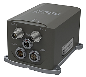
SBG Systems has released the Apogee Series, its most accurate inertial navigation systems based on robust and cost-effective MEMS technology. The INS/GNSS integrates the latest generation of MEMS sensors and a tri-frequency GNSS receiver. Apogee achieves 0.008° in roll and pitch in real-time and 0.005° in post-processing. With two antennas, it delivers a robust and accurate heading.
Four models compose the Apogee line.
The Apogee-A provides only orientation data.
The Apogee-N additionally embeds a GNSS receiver; it is a compact solution with one antenna for land and aerial applications.
The Apogee-D embeds a dual-antenna GNSS receiver for accurate heading under low dynamics conditions.
The Apogee-E delivers navigation data when connected to an external GNSS receiver or to the SplitBox with integrated GNSS.
Mobile Mapping. Apogee can be precisely synchronized with LiDAR equipment because of a UTC time-stamping accurate to 1 microsecond. This integrated INS/GNSS provides optimal position in multipath environment or during GNSS outages, thanks to a tight GNSS integration and the continuous fusion of inertial and odometer data. To get the required positioning accuracy, Apogee supports RTK and Precise Point Positioning services (Omnistar, Terrastar, and more).
Aerial Mapping and Remote Sensing. With very low noise gyroscopes, low latency, and high resistance to vibrations, the Apogee allows aerial surveys by plane or helicopter. It provides real-time orientation and position data with direct fusion of inertial and GNSS information. Compact, lightweight and low power, the Apogee is easy to install, and has an embedded web interface for configuration.
Post-processing. Orientation and position data can be recorded in the Apogee data logger. At the office, the user imports data in the post-processing software. This tool gives access to several RTK networks and reference station offline data (such as VRS and CORS.) Additionally, it enhances orientation and position accuracy by a complete “backward/forward” calculation.
“SBG Systems manufactures inertial systems from the concept to the production. The Apogee benefits from our high level of expertise in integrated design, IMU calibration, testing, and filtering,” said Alexis Guinamard, CTO of SBG Systems.
All models are available for order. Below is a promotional video with more information.
Apple is working on its own autonomous car, according to Reuters. An auto industry source told Reuters that the tech giant is gathering information and parts to make a prototype for the autonomous electric vehicle — the entire car, not just automotive software or components.
“They don’t appear to want a lot of help from carmakers,” said the unnamed source.
Apple is gathering advice on parts and production methods, focusing on electric and connected-car technologies, while studying the potential for automated driving, the source told Reuters.
“Fully automated driving is an evolution. Carmakers will slowly build the market for autonomous cars by first releasing connected and partially automated cars,” the source said. “Apple is interested in all the potential ways you can evolve the car; that includes autonomous driving.”
Meanwhile, Sony is also turning to autonomous vehicles, according to USA Today. The electronics giant is teaming up with Japanese robotics company ZMP to develop self-driving automobiles, reports the Financial Times. Sony invested 100 million yen (about $842,000) in ZMP.
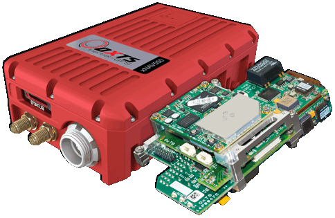
OxTS has released the xNAV550, its new compact and lightweight GNSS-aided inertial navigation system, along with an OEM board set version, the xOEM550.
xNAV550. The xNAV550 is the latest model in the xNAV family and the first to offer a position accuracy of 2 cm, yet remains a compact GNSS-aided inertial navigation system at 425 grams. Suitable for all applications where size and weight as well as performance matter, it is designed for use on UAVs and in other weight-constrained applications.
Featuring dual GNSS receivers and a custom-built inertial measurement unit, the xNAV550 constantly monitors position, orientation and velocity with high accuracy in real-time. Four gigabytes of on-board storage is available, automatically logging data for an added layer of protection. Data can be downloaded from the system and post-processed using OxTS’s advanced software, which is included as standard at no extra cost.
Integrating the xNAV550 with cameras, laser scanners or other sensor arrays is easy using the NMEA outputs, OxTS said, with 1-PPS and event input triggers for synchronization and time stamping. These features and the convenience of the one-box solution ensure that the xNAV550 make it quick and easy to acquire accurate data required for direct georeferencing, the company said.
xOEM550. The xOEM550 is designed for system integrators looking for a high-performance INS to build into a complete scanning and georeferencing system. Weighing 165 grams, it won’t add bulk to a system, and the free and distributable OxTS post-processing software enables system integrators to offer a turnkey solution at a competitive price, the company said.
OxTS will be exhibiting at ILMF 2015 in Denver, Colo., Feb. 23-25. Stop by Booth #30 to take a look at the xNAV and xOEM systems or contact [email protected] for more information.
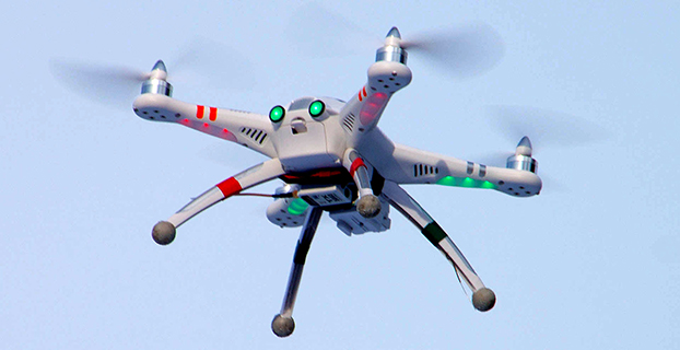
A Walkera QR X350 quadcopter. (Photo credit: Wikimedia Commons).
The Federal Aviation Administration has proposed a framework of regulations that would allow routine use of certain small unmanned aircraft systems (UAS) in today’s aviation system for commercial purposes.
“We have tried to be flexible in writing these rules,” said FAA Administrator Michael Huerta in a statement. “We want to maintain today’s outstanding level of aviation safety without placing an undue regulatory burden on an emerging industry.”
The FAA proposal offers safety rules for UAS under 55 pounds conducting “non-recreational” operations. The rule would limit flights to daylight and visual line-of-sight operations. It also addresses height restrictions, operator certification, optional use of a visual observer, aircraft registration and marking, and operational limits.
The proposed rules also includes extensive discussion of the possibility of an additional, more flexible framework for “micro” UAS under 4.4 pounds. The FAA is asking the public to comment on this possible classification to determine whether it should include this option as part of a final rule. The FAA is also asking for comment about how the agency can further leverage the UAS test site program and an upcoming UAS Center of Excellence to further spur innovation at “innovation zones.”
The public will be able to comment on the proposed regulation for 60 days from the date of publication in the Federal Register. The FAA also intends to hold public meetings to discuss innovation and opportunities at the test sites and Center of Excellence. These meetings will be announced in a future Federal Register notice.
“Technology is advancing at an unprecedented pace, and this milestone allows federal regulations and the use of our national airspace to evolve to safely accommodate innovation,” said Transportation Secretary Anthony Foxx.
The proposed rule would require an operator to maintain visual line of sight of a small UAS. The rule would allow, but not require, an operator to work with a visual observer who would maintain constant visual contact with the aircraft. The operator would still need to be able to see the UAS with unaided vision (except for glasses). The FAA is asking for comments on whether the rules should permit operations beyond line of sight, and if so, what the appropriate limits should be.
Under the proposed rule, the person actually flying a small UAS would be an “operator.” An operator would have to be at least 17 years old, pass an aeronautical knowledge test and obtain an FAA UAS operator certificate. To maintain certification, the operator would have to pass the FAA knowledge tests every 24 months. A small UAS operator would not need any further private pilot certifications (such as a private pilot license or medical rating).
The new rule also proposes operating limitations designed to minimize risks to other aircraft and people and property on the ground:
A small UAS operator must always see and avoid manned aircraft. If there is a risk of collision, the UAS operator must be the first to maneuver away.
The operator must discontinue the flight when continuing would pose a hazard to other aircraft, people or property.
A small UAS operator must assess weather conditions, airspace restrictions and the location of people to lessen risks if he or she loses control of the UAS.
A small UAS may not fly over people, except those directly involved with the flight.
Flights should be limited to 500 feet altitude and no faster than 100 mph.
Operators must stay out of airport flight paths and restricted airspace areas, and obey any FAA Temporary Flight Restrictions (TFRs).
The proposed rule maintains the existing prohibition against operating in a careless or reckless manner. It also would bar an operator from allowing any object to be dropped from the UAS.
Operators would be responsible for ensuring an aircraft is safe before flying, but the FAA is not proposing that small UAS comply with current agency airworthiness standards or aircraft certification. For example, an operator would have to perform a preflight inspection that includes checking the communications link between the control station and the UAS. Small UAS with FAA-certificated components also could be subject to agency airworthiness directives.
The new rules would not apply to model aircraft. However, model aircraft operators must continue to satisfy all of the criteria specified in Sec. 336 of Public Law 112-95, including the stipulation that they be operated only for hobby or recreational purposes. Generally speaking, the new rules would not apply to government aircraft operations, because we expect that these government operations will typically continue to actively operate under the Certificate of Waiver or Authorization (COA) process unless the operator opts to comply with and fly under the new small UAS regulations.
In addition to this proposal, earlier today, the White House issued a Presidential Memorandum concerning transparency, accountability, and privacy, civil rights, and civil liberties protections for the Federal Government’s use of UAS in the national airspace system, which directs the initiation of a multi-stakeholder engagement process to develop a framework for privacy, accountability, and transparency issues concerning commercial and private UAS use.
The current unmanned aircraft rules remain in place until the FAA implements a final new rule. The FAA encourages new operators to visit www.knowbeforeyoufly.org.
Antenna maker Maxtena has launched an L1 L2 GPS/GLONASS active helix antenna for GNSS satellite applications. The new antenna M1227HCT-A2-SMA antenna will replace its predecessor the M1227HCT-A-SMA antenna, which made its debut in 2010.The new antenna has been mechanically upgraded. It is packaged in a high-quality, durable IP67/68 sealed radome housing and terminated with a gold-plated SMA connector for RF feed/input and DC bias/power typically powered from the applications’ GNSS RF module.
The M1227HCT-A2-SMA active helix design features Maxtena’s patented compact and light-weight Helicore Quadrifilar antenna technology and a built-in dual-stage low noise amplifier (LNA) and filtering, offering up to 30-dB gain for GNSS applications that use GLONASS and GPS in one radome housing with a single 50-Ohm SMA connector.
The tiny antenna is designed for applications across various markets such as UAVs, GIS and wearable GNSS.
Aerial photographer Raphael Pirker has settled the civil penalty proceeding brought by the U.S. Federal Aviation Administration in 2013 concerning his flight of a styrofoam Zephyr II model aircraft (or “drone”) at the University of Virginia at Charlottesville in October 2011.
The $1,100 settlement “does not constitute an admission of any of the allegations in the case or an admission of any regulatory violation,” Pinker’s attorney Brendan Schulman said in a statement.
On December 1, the National Transportation Safety Board ruled in favor of the FAA, when the FAA appealed a decision by an NTSB Administrative Law Judge in Huerta v. Pirker after the judge dismissed the FAA’s order requiring Pirker to pay a civil penalty of $10,000 for operating an unmanned aircraft in a careless or reckless manner at the University of Virginia in October 2011.
Pinker was said to have been hired to supply aerial photographs and video of the university campus and medical center. He had argued that his aircraft, which was described as an UAS, was in fact a model aircraft.
Schulman wrote: “We are pleased that the case ignited an important international conversation about the civilian use of drones, the appropriate level of governmental regulation concerning this new technology, and even spurred the regulators to open new paths to the approval of certain commercial drone operations.
“The decision to settle the case was not an easy one, but the length of time that would be needed to pursue further proceedings and appeals, and the FAA’s new reliance on a statute that post-dates Raphael’s flight, have diminished the utility of the case to assist the commercial drone industry in its regulatory struggle.”