Tag: autonomous vehicles

  • Draganfly tapped to detect dangerous unexploded landmines

    Draganfly tapped to detect dangerous unexploded landmines

    Photo: Gannet77/E+/Getty Images
    Photo: Gannet77/E+/Getty Images

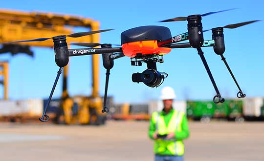
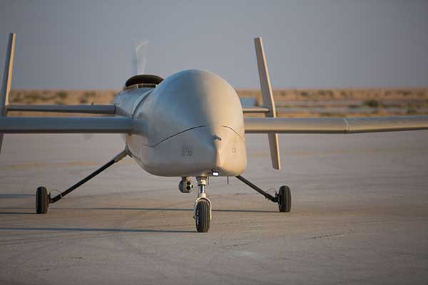
    Draganfly Inc., a leading North American-based commercial drone company, is partnering with Windfall Geotek to develop drone-based solutions for landmine detection.

    Windfall Geotek is a Quebec-based technology services company and a leader in the use of artificial intelligence (AI) and advanced knowledge-extraction techniques in the mining sector.

    The companies will work to develop an artificial intelligence (AI) driven unmanned aerial systems solution for landmine detection in the defense, humanitarian and other sectors in which the companies have expertise.

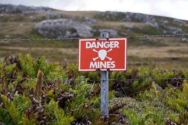
    While landmines have been used since World War I, their deployment proliferated from the 1960s onwards. To this day, many unexploded devices are killing and maiming people who step on or trigger the bombs unintentionally.

    About 60 countries and territories are still contaminated with anti-personnel mines, and more than 120,000 people were killed or injured by landmines between 1999-2017, according to research by Landmine Monitor.

    Terms of the agreement include joint research, development and engineering support, drones and equipment o further commercialize an AI driven drone solution for the detection and elimination of landmines, unexploded ordnance and.improvised explosive devices (IEDs).

    In 2018, governments and nonprofits allocated nearly US$700 million in combined international
    and national support for mine action in 2018. The economic impact of landmines is estimated at $100 billion.

    “We have been evaluating drone solutions for nearly a year, and after an exhaustive analysis of the market and providers, it is exciting to select Draganfly as our first drone systems partner for this worthwhile initiative,” said Dinesh Kandanchatha, chairman of Windfall Geotek.

    “Windfall Geotek is the industry leader in AI-based digital exploration for mining. When they approached us on this project, it seemed like a natural fit to partner our engineering and drone capabilities, with their proven software and AI expertise,” sid Cameron Chell, CEO, Draganfly. “The two companies share a mission of saving lives through technology. We expect this partnership to generate new and expanded revenue streams for both companies in the defense sector, public safety and other markets where both companies have expertise.”

  • Pandemic drones to monitor, detect those with COVID-19

    Pandemic drones to monitor, detect those with COVID-19

    Draganfly will integrate a breakthrough health diagnosis onto cameras and UAVs to combat coronavirus.

    In a rush to combat the global spread of the deadly coronavirus (COVID-19) in the U.S., Draganfly will deploy “pandemic drones” to remotely monitor and detect people with infectious and respiratory conditions to help stop the spread of the disease.

    The Draganfly drones will be fitted with a specialized sensor and computer vision system that can monitor temperature, heart and respiratory rates, as well as detect people sneezing and coughing in crowds and other places where groups of people may work or congregate.

    Draganfly will serve as the global systems integrator for the Vital Intelligence Project, a health and respiratory monitoring platform from Vital Intelligence Inc. The breakthrough technology was developed in a collaboration between the University of South Australia and the Science and Technology Group (DST), which is part of Australia’s Defence Department.

    Coughing detected

    The sensing system uses existing and new camera networks, UAVs and remotely piloted aircraft systems for health monitoring and detection of infectious and respiratory conditions — including monitoring temperatures, heart rates and respiratory rates.

    The drones can monitor people in public crowds, workforces, airlines, cruise ships, convention centers, border crossings or critical infrastructure facilities. The technology can also be used to monitor potential at-risk groups, such as seniors in care facilities.

    The Draganfly demonstration video below shows the camera detecting not only temperature, heart rate and respiration, but when a person is coughing.

    Draganfly Video


    Under the exclusive contract, initially budgeted at $1.5 million, Draganfly will use its engineering, integration and distribution expertise as well as its secure supply chain for immediate commercialization and deployment of the technology.

    “The university and Defence supported my team’s efforts to develop automation for use in epidemics and disasters,” said Javaan Chahl, Defence Science and Technology Chair at the University of South Australia. “We had imagined the technology being used in a future relief expedition to some far-away place. Now, shockingly, we see a need for its use in our everyday lives immediately. Draganfly’s industrial know-how is quickly helping us ensure our research can save lives.”

    The Draganflyer Commander UAV is a remotely operated miniature helicopter designed to carry wireless camera systems. (Photo: Draganfly)
    The Draganflyer Commander UAV is a remotely operated miniature helicopter designed to carry wireless camera systems. (Photo: Draganfly)

    “Draganfly has been selected because of its proven leadership in an industry so important to public safety at such a critical time. We look forward to working with global agencies and industry to rapidly deploy this important technology,” said Cameron Chell, Draganfly CEO.

    “Draganfly is honored to work on such an important project given the current pandemic facing the world with COVID-19,” said Andy Card, Draganfly director and former U.S. Secretary of Transportation and White House chief of staff. “Health and respiratory monitoring will be vital for not only detection, but also utilizing the data to understand health trends. As we move forward, drones and autonomous technology doing detection will be an important part of ensuring public safety.”

    “With fighting epidemics rising as a global priority, new versatile technologies, such as humanitarian mission UAVs, are immediately needed to detect and track outbreaks so that critical interventions can be deployed sooner and with greater effectiveness,” said Jack Chow, advisor to the Vital Intelligence Project. Chow is a former first assistant director-general on infectious diseases for the World Health Organization (WHO).

  • Drone projects summarized in Europe air traffic management report

    Drone projects summarized in Europe air traffic management report

    Cover: SESAR JC
    Cover: SESAR JC

    Drone technology takes center stage in a new European report on the continent’s air traffic management.

    U-Space: Supporting Safe and Secure Drone Operations in Europe, is a 42-page preliminary summary of SESAR U-space research and innovation results, following 19 demonstrations that took place from 2017 through 2019.

    The research and demonstration projects addressed topics such as drone operations; critical communications; surveillance and tracking; information management; aircraft systems; ground-based technologies; cyber-resilience; and geo-fencing.

    “Drones are disrupting business as usual in air traffic management,” said Florian Guillermet, executive director, SESAR Joint Undertaking. “A simple adaptation of our current air traffic management system is not enough; accommodating these air vehicles in the numbers forecast requires a new approach.”

    The projects map progress on development of the technological capabilities and all services
    required for making U-space a reality, starting with foundation services (U1) before progressing to initial services (U2), advanced services (U3) and finally full services (U4).

    Results of the projects summarized in the brochure will be fully detailed in a comprehensive report, expected to be published in the second half of 2020.

    Photo:
    Chart: SESAR JC

    SESAR 2020

    SESAR 2020 is a European Union innovative program for researching the future of air traffic management in Europe. It builds on its predecessor, SESAR 1, to deliver high-performing operational and technological solutions for uptake by the aviation industry.

    With a budget of 1.6 billion euros between now and 2024, SESAR 2020 will support projects to deliver solutions in these four key areas:

    • airport operations
    • network operations
    • air traffic services
    • technology enablers.

  • European drone-airspace integration project kicks off

    European drone-airspace integration project kicks off

    Photo by: aerogondo/iStock/Getty Images Plus/Getty Images
    Photo: aerogondo/iStock/Getty Images Plus/Getty Images

    GMV has been awarded the SUGUS project (Solution for E-GNSS U Space Service), which aims to speed the adoption of GNSS and Galileo in the unmanned aerial vehicle (UAV) segment and ensure safe airspace access by unmanned aircraft.

    SUGUS is an 18-month, 485,000-euro European Union research and development project. A series of trials will be held to show the benefits of E-GNSS for drone operators as well as its approval by aviation authorities.

    The project will be carried out by a GMV-led consortium including Everis Aerospace, Defense and Security; VVA Brussels; EGNOS service provider ESSP; FADA-CATEC and Unifly.

    The demand for UAV services is steadily increasing, with the potential to generate significant economic growth, as recognized in the 2015 European Union Aviation Strategy. More recently, the 2016 European Drones Outlook Study (by SESAR — Single European Sky ATM Research) estimated that the European drone market will clock up 10 billion euros a year by 2035 and more than 15 billion euros annually by 2050.

    U-Space services

    U-Space is a set of new airspace-management services and procedures designed to ensure airspace access too UAVs while looking out for operational security, the right to privacy and the safety of persons and infrastructure. These services rely on a high level of digitization and function automation, whether onboard the drone itself or part of the ground-based environment.

    Several initiatives are underway in Europe to develop U-Space and work toward the safe and efficient coexistence of manned and unmanned air traffic.

    At the same time, new European legislation on operating unmanned systems is providing a uniform, Europe-wide framework. The new regulation is broken down into three drone operation categories:

    • Open, calling for no AESA clearance or operator declaration
    • Specific, where both clearance and declaration will be necessary
    • Certified, reserved for riskier operations.

    To help integrate drones into the airspace, SUGUS will center on the Open and Specific flight categories.

    SUGUS tasks

    SUGUS will demonstrate the benefits for drone operations of the measures implemented at service-provision level and the new EGNSS API (European GNSS application programming interface) to be implemented in the project.

    These benefits included the mitigation of operating risks, improvement of preparation processes and clearance of the operator’s mission. Such measures as expected to ease future urban aerial mobility operations, such as aero taxis or parcel delivery.

    For the first step in this endeavor, SUGUS will carry out a review of the results of previous EGNSS projects while also pinpointing the needs of drone operators and unmanned traffic service providers in complex operations and built-up areas.

    This analysis will help to define and then implement the new EGNSS-based API.

    SUGUS will also be running several flight trials in complex environments to prove the benefits of the drone-operation measures. The overarching idea is to raise awareness and contribute towards drone standardization and regulation to maximize the chances of the proposed services being implemented as a U Space service.

  • Defense contracts spur growth of counter drone company

    Defense contracts spur growth of counter drone company

    Titan C-UAS systems are deployed globally, protecting combat forces, civilians, and critical infrastructure. (Photo: Citadel Defense)
    Titan C-UAS systems are deployed globally, protecting combat forces, civilians, and critical infrastructure. (Photo: Citadel Defense)

    U.S. military, government and international customers opt for Citadel’s Titan for drone protection

    Citadel Defense continues to experience rapid growth after being awarded several significant Defense and Homeland Security contracts for its C-UAS (counter unmanned aircraft systems) solutions.

    Malicious drone activity, ranging from single-use hostile small unmanned aerial systems to drone swarms continue to threaten safety and national security. Over the past 18 months, Citadel has received orders for more than $17.5 million in products and services to support anti-drone initiatives around the world.

    According to the company, the growth is a direct result of delivering reliable and effective force protection against individual drones and swarms for military, government and international customers over the past two years.

    Citadel Defense’s automated counter drone solution uses artificial intelligence and machine learning as a reliable and scalable approach for addressing emerging threats.

    To address the surge in global demand for Titan systems, Citadel has expanded its manufacturing capabilities in San Diego, California, to support production of up to 50 Titan systems a month. The company uses U.S. suppliers with more than 70% of components being sourced locally in Southern California to improve responsiveness when executing on urgent customer requests.

    As new drones are released to the market, Titan systems receive new software to address the new threats. If Titan’s AI algorithms do not detect the threat right away, the company explained that it can deliver an end-to-end capability in 72 hours for most drones and less than 4 weeks for the most complex drone signals.

    The use of AI, deepnets and adaptive countermeasures provide Titan with scalable force protection that can address the needs of the small unit, a large base or A mobile vehicle. The Titan system is being effectively integrated into layered solutions that combine radar, optics and kinetic countermeasures to help customers detect, identify, track, defeat and report on threat sUAS.

    “Designing agility into our product development process from the beginning has allowed us to iterate in real-time alongside our customers and rapidly deploy new capabilities to improve mission outcomes,” said Christopher Williams, CEO of Citadel Defense.

    As radiofrequency-based solutions become an important requirement for layered C-UAS solutions, Citadel has had its capabilities extensively evaluated by U.S. Army, Navy, Air Force, SOCOM, and DHS Test & Evaluation teams. Titan is being used to protect high-value assets in urban, rural and maritime environments.

    “Designing our system to meet unpredictable mission scenarios was made possible by direct feedback from operators experiencing drone incursions on the front lines,” explained Williams. “The threat environment is always evolving which requires a product development approach that can adapt and respond. A combination of human-centered design and AI-powered technology have helped Citadel differentiate ourselves from traditional defense contractors.”

  • Telstra partners with TEOCO on UAV strategy

    Telstra partners with TEOCO on UAV strategy

    Telstra logoAnalytics provider Teoco has been selected by Telstra — a mobile network in Australia — to assist with the development of its UAV strategy.

    Telstra will use Teoco’s AirborneRF solution to assess the readiness of its radio access network for future UAV applications, including communications, navigation, surveillance, safety and identity.

    Teoco is a provider of analytics, assurance and optimization solutions to more than 300 communication service providers (CSPs) and OEMs worldwide.

    Already deployed by several tier-one operators globally, AirborneRF ensures effective, mission-critical connectivity to enable effective traffic management and control for UAVs in the lower airspace. Telstra will use the solution to develop a platform for enabling a multitude of mission-critical services, vital in supporting successful UAV operations.

    The platform provides a link between cellular networks and aviation systems, such as air traffic management (ATM), unmanned traffic management (UTM) and flight information management systems (FIMS).

    TEOCO’s AirborneRF solution will play an important role in assisting Telstra enable a safe, equitable, secure and reliable urban air space platform. This has become all the more important to Telstra following Uber’s decision in 2019 to use Melbourne as one of three pilot cities to test out its “flying taxis” — the pilot is expected to begin this year, with commercial operations planned for 2023.

    Telecommunications companies can provide needed UAV services via their mobile networks. For the internet of things (IOT), they can provide drone registration, activation and identification. For 5G, they can provide super low-latency remote command and control and high-resolution video carriage.

    “We have been running a number of drone-related technology assessments with various industry customers, within law enforcement, humanitarian aid, post disaster, first responders and city councils, over the past 12 months,” said Thomas Neubauer, vice president of Business Development, TEOCO.

    “Commercial UAVs present a huge opportunity for [[telecommunications]] operators, but only if supporting mobile networks deliver the required connectivity to keep them airborne,” Neubauer said. “Mobile networks were not designed to meet the needs of the aviation industry, so tight focus is needed to guarantee the quality of service needed to safeguard the additional revenue that connected skies promise. Our Airborne RF solution offers this guarantee to a growing number of major operators around the world.”

  • UPS to develop new delivery drones with Wingcopter

    UPS to develop new delivery drones with Wingcopter

    UPS Flight Forward (UPSFF) is collaborating with German drone-maker Wingcopter to develop the next generation of package delivery drones for a variety of use cases in the United States and internationally. UPSFF is a subsidiary of UPS dedicated to drone delivery.

    UPS chose Wingcopter for its unmanned aircraft technology and its track record in delivering a variety of goods over long distances in multiple international settings.

    “Drone delivery is not a one-size-fits-all operation,” said Bala Ganesh, vice president of the UPS Advanced Technology Group. “Our collaboration with Wingcopter helps pave the way for us to start drone delivery service in new use-cases. UPS Flight Forward is building a network of technology partners to broaden our unique capability to serve customers and extend our leadership in drone delivery.”

    Drone fleet. As part of this collaboration — UPSFF’s first new relationship with a drone manufacturer since its formation — both companies will work toward earning regulatory certification for a Wingcopter unmanned aircraft to make commercial delivery flights in the United States. It also is a critical step toward building a diverse fleet of drones with varying capabilities to meet potential customer needs.

    The Wingcopter drones feature vertical takeoffs and landings in tight spaces, transitioning to efficient, high-speed horizontal flight, enabling ranges suitable for a variety of uses. These capabilities will allow UPSFF to begin developing solutions that, if approved, will go well beyond the healthcare and retail industries to solve long-standing challenges for high-tech, industrial manufacturing, hospitality, entertainment and other customers.

    Wingcopter  drones have taken part in numerous beyond-visual-line-of-sight (BVLOS) projects and been used by diverse customers around the world — from commercial, factory-to-factory deliveries to life-saving humanitarian projects and emergency medical supply.

    For example, Wingcopter delivered insulin to an Irish island in the North Sea that is frequently cut off from the mainland because of bad weather. On the South Sea island of Vanuatu, the start-up, on behalf of the local Ministry of Health and supported by UNICEF, successfully set up an on-demand vaccines supply, delivering the urgently needed serums within minutes to multiple different health centers.

    Core innovation. The company’s electric vertical takeoff and landing drones have a patented tilt-rotor mechanism, which enables a seamless transition between two drone modes: multicopter for hovering and fixed-wing for low-noise forward flight. The aerodynamic Wingcopter aircrafts operate with stability even in harsh weather conditions.

    In 2019, UPSFF began operating commercial drone delivery flights in the UPS network, starting with delivery service at WakeMed’s flagship hospital and campus in Raleigh, N.C. Since then, the company has delivered thousands of medical samples via drones, supplementing a ground courier service.

    UPSFF later announced plans to establish drone delivery services on several healthcare campuses and has been exploring the use of drones to deliver retail, prescriptions and medical products in residential settings.

    In September 2019, UPSFF received the U.S. government’s Standard Part 135 certification to operate a drone airline, and has also completed drone deliveries under the U.S. Federal Aviation Administration’s Part 107 rules within the FAA’s Integration Pilot Program.

    “We are proud to partner with UPS, a global giant in delivery and logistics. Together we aspire to extend the speed and reach of package delivery,” said Tom Plümmer, Wingcopter chief executive officer and co-founder. “Our vision has always been to leverage technology to improve the lives of people around the world, and the strategic relationship with UPS will further accelerate our growth and global expansion, strengthening our role as an industry leader in drone technology.”

  • Farming by Satellite Prize 2020 opens for applications

    Farming by Satellite Prize 2020 opens for applications

    The competition promotes the use of GNSS and Earth observation in European and African agriculture

    The European GNSS Agency (GSA) is bringing back the Farming by Satellite Prize. Registration is now open for young innovators to explore the use of satellite technologies in agriculture to enable sustainable farming practices, improve efficiency and reduce the environmental impact.

    The Farming by Satellite Prize is a joint initiative with the European Environment Agency (EEA), the European Union agency that provides independent information on the environment to decision makers and the public. The EEA also manages the Copernicus Land Monitoring Service and cross-service in situ coordination.

    Innovation is crucial for the growth and sustainability of the agricultural sector, enabling it to respond to emerging global challenges such as the rise of the global population and the impact of climate change.

    The Farming by Satellite Prize is designed to encourage young professionals, farmers and students in Europe to create new, sustainable and environmentally friendly solutions using Copernicus, EGNOS and Galileo.

    The 2020 edition of the Farming by Satellite Prize includes the Special Africa Prize, which aims to encourage young Africans to develop satellite-based solutions able to cater to the specific needs and resources of communities and lands in Africa.

    “Who would have thought that Galileo and Copernicus would have convinced the young farmers to become tech-savvy entrepreneurs bringing innovation gained by space data to improve quality of life,” said Pascal Claudel, acting executive director of the GSA. “We need young farmers to be innovative to develop a competitive and yet sustainable agriculture. Of course, they take advantage of what is available thanks to space technologies and our objective with this competition is to support them to reach the best possible solution.”

    “It is clear that we need to make food production much more sustainable and lessen its impact on the environment and climate,” said Hans Bruyninckx, EEA executive director. “Satellite data, technology and innovation can support this change, which is why partnering with this initiative aligns well with the EEA’s commitment to protecting our nature, climate and human health.”

    Applicants can take part as individuals or as a team and are invited to register online between March 16 and June 15. The top teams will be selected as finalists to enter the deep dive phase. A total prize purse of €10K will be distributed among the top four applicants.

    The 2020 edition of the Farming by Satellite Prize is supported by industry partners with the sponsorship of CLAAS, a manufacturer of agricultural engineering equipment. Full details on the competition are available at www.farmingbysatellite.eu. Participants are invited to register early and submit their full written application before the registration deadline on June 15 deadline.

    Photo: subman/E+/Getty Images
    Photo: subman/E+/Getty Images
  • UAVs monitor marine emissions, string powerlines

    UAVs monitor marine emissions, string powerlines

    A couple of interesting drone applications came up this month — marine smoke emission monitoring and studies from a little known European drone manufacturer.

    Monitoring marine emissions

    Climate change: Some might say these are words we don’t really need to hear. Such a big to-do about how much human activity is affecting the weather changes that we are now seeing globally. Or is it all part of a natural cycle that the Earth is going through as many might say?

    I don’t really want to get into that argument, but it would seem useful that someone is doing something to reduce the use of dirty fuels by ships. After all, we seemed to readily acquiesce to unleaded fuel for our vehicles without a lot of protest; why would we accept this as the norm when marine transport still uses dirty bunker fuel, belching out a significant amount of pollution?

    If it’s good for people and their cars, and we quite possibly incurred some costs getting there, why not stick it on the marine industry too?

    So that’s what the International Maritime Organization (IMO) did in January this year, reducing the allowable sulphur content in marine fuel from 3.5 to 0.5%. Enforced under the international convention for the prevention of pollution from ships, this is aimed at cutting sulphur oxide emissions from ships by 77%, equivalent to a reduction of about 8.5  million metric tons annually.

    That’s the tricky bit – enforcement. Ships spend most of their time miles away from land, so knowing what their smoke emissions contain is somewhat difficult. Now (this is where I manage to tie things back to what I’m supposed to be reporting on) its useful that Schiebel, along with its partner operator Nordic Unmanned, thought about enforcement of the new regulations.

    Schiebel Camcopter S-100. (Photo: Schiebel)
    Schiebel Camcopter S-100. (Photo: Schiebel)

    With a range of up to 200 kilometers (~125 miles) the Camcopter S-100 can get out to the shipping lanes to check on what’s coming out of the smokestacks. Equipped with an automatic identification system (AIS), a sulphur sniffing sensor and an L3 Harris Wescam MX-10 real-time electro-optical/infrared (EO/IR) camera, the “enforcement drone” can determine which ship it’s flying over, what the smoke plume sulphur content might be, and even take geo-coded pictures to show in which jurisdiction the ship is sailing. If necessary, it can even take pictures of who’s throwing what at the overflying UAV.

    In recent tests, the Camcopter flew out of Gniben, Denmark, where European regulations on emissions applied, and marine exhaust fumes are limited to contain no more than 0.1 percent sulphur oxide. The Camcopter S-100 performed two 4- hour flights and provided real-time readings of the sulphur level in ships’ exhaust plumes.

    With these successful tests in the bag, Nordic Unmanned has indicated its capabilities to worldwide maritime authorities that they are ready and able to help enforce the new IMO regulations.

    European-built multi-rotor drone

    Acecore Technologies in the Netherlands makes multi-rotor drones which have found some unique applications:

    The NEO 8-rotor UAV. (Photo: Acecore)
    The NEO 8-rotor UAV. (Photo: Acecore)

    Stringing power-lines using NEO (SPIE website)

    In order to extend power transmission line capacity, the approach used is often to first pull a lead cable. This  normally involves several power company personnel and a whole bunch of specialized equipment.

    However, in a first-of-its-kind test, SPIE Nederland used an Acecore NEO drone to pull a lead cable over 150 meters between high-voltage pylons.

    Equipped with suitable cameras and other sensors, Acecore drones have also been used for power-line and gas-plant thermal inspection, movie making (including Game of Thrones), live broadcasts, autonomous aerial surveying, and tethered security applications. They also make crop health monitoring possible.

    Designed with durability in mind, Acecore drones are weather-proof, built with strong carbon-fiber frames, have triple redundant autopilots, and are ADS-B-ready to broadcast GPS position to support sense-and-avoid capability.

    Acecore is also promoting the fact that its drones and controllers are manufactured entirely with European parts. In other words, they would like to grab a chunk of DJI’s huge market share by jumping on an apparent global move to switch over from Chinese sourced goods and equipment.

    So, drones are taking on environmental monitoring. They’re reducing the environmental impact of transmission-line build-out. And they’re moving  toward building drones locally — all are interesting new applications of unmanned aircraft systems.

    Tony Murfin
    GNSS Aerospace

  • AUVSI Xponential show postponed until August

    AUVSI Xponential show postponed until August

    AUVSI Xponential 2020 logoThe AUVSI Xponential trade show has been postponed due to COVID-19, with a tentative reschedule date planned for August.

    AUVSI Xponential 2020 was scheduled be held at the Boston Convention and Exhibition Center May 4-7. AUVSI has identified Aug. 9-12 as tentative dates to reschedule the event.

    AUVSI Xponential is a large event for the unmanned aerial vehicle (UAV) and unmanned, autonomous industries. Held for the past 47 years, the conference attracts more than 8,500 attendees and 700 exhibitors from around the world.

    “Based on currently available information, and with the best interests of our members, exhibitors, attendees and the global community in mind, the AUVSI Board of Directors has made the difficult but necessary decision to postpone AUVSI Xponential 2020,” said Brian Wynne, president and CEO of AUVSI.

    Plans to conduct Xponential 2020 in August may change given how rapidly the COVID-19 situation is evolving. In the meantime, AUVSI will provide updates as information becomes available.

    “We will continue to actively assess all potential opportunities to best serve the needs of our community while delivering the world-class event you have come to expect from AUVSI,” Wynne said.

    AUVSI has created an email address, [email protected], for submitting inquiries about the plans to reschedule Xponential 2020. The association’s staff will respond to questions and concerns about the conference as quickly as possible.

    “We appreciate the incredible support, cooperation and patience we have received from the unmanned systems community as we work through this evolving global issue,” Wynne said.

  • UAVOS and King Abdulaziz City collaborate on flight control system

    UAVOS and King Abdulaziz City collaborate on flight control system

    Photo: UAVOS
    Photo: UAVOS

    UAVOS company is collaborating with King Abdulaziz City for Science and Technology (KACST), Saudi Arabia, on scientific research and development of a new Flight Control System (FCS). The FCS is designed to fit and leverage multi-mission, multi-domain UAV platforms.

    Together, the research and development (R&D) partners have created a Saker-1B Medium Altitude Long Endurance (MALE) UAS (unmanned aerial system). The specifications of the UAV system has been confirmed by more than 500 hours of day and night test missions under various weather conditions.

    A total of 1,000 hours of take-off and landing test missions were successfully performed, with the long-endurance flights lasting up to 19 hours. The UAV is equipped with a satellite communication data link for beyond-visual-line-of-sight (BVLOS) operation.

    Watch the Saker-1B in action:

    UAVOS and KACST have been jointly developing Flight Control System capability for UAS for 10 years. R&D partners have completed performing the flight tests of their UAS in Saudi Arabia to verify easy and fully autonomous online and offline operation of the unmanned aircraft from takeoff to landing.

    These test missions followed various other successful operational exercises performed in the last few months. The Saker-1B MALE UAS has been proven to operate in harsh desert with long-endurance, high-altitude and high-speed flights. High performance of satellite data link for command and control was demonstrated.

    Due to availability of the current UAVOS autopilot technology, the UAS received sustainability to jamming attacks and advanced data security.

    The Saker-1B performed a series of heavy weight landing tests with the maximum weight (MTOW) 2,500 pounds (1,100 kilograms). A number of different payloads were tested in surveillance experimental missions to confirm overall system performance and its readiness for real applications.

    The UAS uses a direct radio link when flying within line of sight, switching seamlessly to a satellite link when flying BVLOS.

    The Saker-1B MALE is an advanced unmanned aerial system with fully autonomous operation capability. It is equipped with automatic taxi-takeoff and landing systems, satellite communication for extended range, and fully redundant avionics.

    The UAV is designed to operate in harsh environments and is adapted to perform in an extremely hostile, dry and dusty ambient air. The UAS is capable of flying for more than 19 hours at an altitude of up to 16,500 feet (5000 м) with a range 1600 miles (2600 km).

    “We’re excited to work with KACST, a world-class organization in science and technology, fostering innovation and promoting a knowledge-based society in the Kingdom of Saudi Arabia,” said UAVOS CEO and Lead Developer Aliaksei Stratsilatau. “Our ultimate goal of the scientific research and development partnership is to make UAV technologies, which can turn vision into the UAV of tomorrow. For 10 years in partnering with KACST, we hold to a singular and enduring mission: to make breakthrough technologies for the unmanned system industry,”Aliaksei Stratsilatau added.

  • Wingtra adds enhanced data capability with Trimble Business Center

    Wingtra adds enhanced data capability with Trimble Business Center

    Photo: Wingtra
    Photo: Wingtra

    With Wingtra’s latest software release, surveyors and geospatial professionals can now directly import WingtraOne drone data into the Trimble Business Center (TBC).

    According to Wingtra, the new integration seamlessly combines WingtraOne high-accuracy drone data within TBC, optimizing drone mapping workflows for survey and construction projects within a single software platform.

    The integration allows users to drag and drop data into the software suite. Automated point cloud tools, such as classification and feature extraction, can then be used to quickly generate surface models, topographic plans and as-built deliverables.

    Photo: Wingtra
    Photo: Wingtra

    “It’s a solid step forward to enable our data to work smoothly with Trimble Business Center,” said Francois Gervaix, Wingtra’s geospatial expert. “TBC is a reference software in the industry, because of its success as a data hub for construction and geospatial workflows. Optimizing the workflow lets TBC users smoothly integrate data from the fastest drone data capture platform on the market — WingtraOne.”

    This latest Wingtra software release that introduced JobXML (TBC file format) compatibility also brought various other product updates. Namely, high-altitude flight capabilities, longer flight times and more intuitive battery level readings in-flight, Wingtra added.