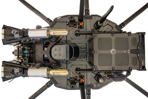
Klau Geomatics has launched MakeItAccurate, a global GNSS data correction and processing service.
MakeItAccurate takes data from any GNSS receiver on drone or survey equipment and makes it accurate. Users can now achieve centimeter (cm)-level accuracy without the need for base stations, real-time kinematic (RTK) links, data from Continuously Operating Reference Station (CORS) or other external inputs.
MakeItAccurate requires only the raw GNSS data from a drone to produce a highly precise trajectory and turn the traditional autonomous 3-5m GPS accuracy to 3-5 cm anywhere in the world.
In many parts of the United States, Europe, Japan, Australia and New Zealand, absolute accuracy of 2-3 cm XYZ will be achieved. In these areas, the KlauPPK processing engine applies sophisticated hybrid PPK/PPP algorithms, merging global PPP clock and orbit corrections with many distant CORS stations to achieve this high absolute accuracy.
The service enables enterprise drone operations to achieve high accuracy across their entire global operations with one repeatable workflow.
Sectors such as insurance, telecommunications and utilities can scale their operations without additional survey expertise and site-specific data constraints. The same process works for multiple operators on thousands of sites enabling consistent, high accuracy every time, the company said.
MakeItAccurate supports data from all GNSS manufacturers. Native support for DJI M 210v2 RTK or Phantom 4 RTK drones returns precise camera positions with centimeter-level accuracy. Other drones using external PPK GNSS products also can achieve highly accurate kinematic trajectories and camera coordinates.
A MakeItAccurate application programming interface (API) is available to push raw GNSS data to the processing engine and return highly accurate coordinates, with full reporting on the accuracy achieved for the entire trajectory or each camera event. GNSS hardware manufacturers can offer a custom service to add value to their products. Software developers offering artificial intelligence technology, photogrammetry processing or other outcomes that benefit from high accuracy can use the MakeItAccurate API.
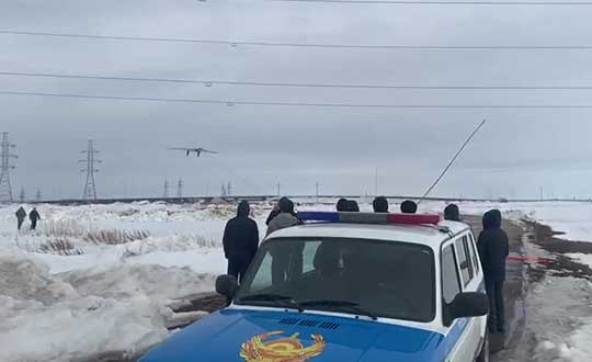
Terra Drone group company KazUAV has helped Nur-Sultan police to use drones to patrol and monitor illegal border movement and slow the spread of coronavirus in Kazakhstan
KazUAV, Kazakhstan drone service provider and a member of Japan-based Terra Drone Corporation, has been working at the frontlines to keep communities safe amid the COVID-19 pandemic outbreak.
Providing direct support to the operational headquarters set up to prevent the spread of coronavirus in Kazakhstan, KazUAV has been helping the Nur-Sultan Police Department to patrol the borders of the locked-down capital city with drones, ensuring “contactless” surveillance and fast-paced operations.
Nur-Sultan is the capital city of Kazakhstan.
The Central Asian nation closed its borders and locked down its main cities, including Nur-Sultan, after confirming the first coronavirus case on March 16. The oil-rich country that borders Russia and China also announced a state of emergency, set to last until April 15, adopting tough measures to combat the pandemic.
Some of the guidelines put forth by the Kazakh authorities include country-wide travel restrictions, suspension of public gatherings, and implementation of stringent sanitation and anti-epidemic measures.
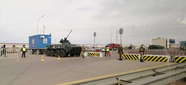
A checkpoint on the border of Nur-Sultan. (Photo: Terra Drone)
All entrances and exits from Nur-Sultan have been completely blocked as part of these measures, mobilizing multiple law enforcement agencies of the Republic of Kazakhstan. Armored vehicles, barriers, and concrete blocks are being used to man the movement from the surrounding villages of Talapker, Karaotkel (Ilyinka), Koyandy, Kosshy and Zhibek-Zholy, on the Nur-Sultan-Petropavlovsk highway.
An additional post has been set up by the municipal government of the Akmola region in Shubary to ensure there are no cases of non-compliance by the Kazakh population.
KazUAV has been directly involved in the collection of information, operational monitoring, and coordination of actions of the Police Department and the Coronavirus Spread Prevention Operational Headquarters for all these areas.
A KazUAV drone takes off to monitor the borders of the Kazakh capital of Nur-Sultan. (Photo: Terra Drone)
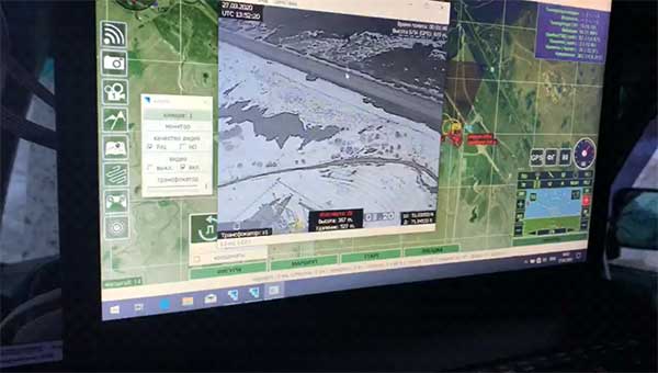
Using drone-mounted cameras with both visible and infrared sensors, the KazUAV team has completed hundreds of flight hours, broadcasting all captured data, as well as the exact coordinates of objects of interest, directly to the operational headquarters command center. This has led to the authorities discovering multiple bypass roads and irregularities in the locked-down area – without which, the quarantine measures could not have proven effective.
When it comes to remote monitoring of vast areas, unmanned aerial vehicles are one of the best tools available to public safety agencies today. As a leading drone service provider in Kazakhstan, KazUAV not only gave Kazakh first responders access to cutting-edge drone technology, the company also assisted the enforcement agencies with the vast experience of its team of specialists, trained to operate day and night in the toughest of weather conditions.
The UAV ground control station at the Coronavirus Spread Prevention Operational Headquarters in Nur-Sultan. (Photo: Terra Drone)
“As international experience has shown, restrictions introduced to prevent the spread of the coronavirus are the most effective measures to fight it,” said Dmitry Ivanov, development director, KazUAV. “Of course, it’s hard for everyone now; it is a challenging time for each one of us. But the call to stay home is more relevant than ever in the context of drones. We are familiar with carrying out critical tasks like monitoring floods or patrolling important events, but this was an emergency request which needed an immediate response.”
DroneHunter F700 is a radar-based autonomous interceptor drone for tracking and stopping dangerous drones
Fortem Technologies Inc. is now shipping its artificial intelligence (AI)-enabled F700 DroneHunter. The F700 is a safe, effective deterrent against a rising number of careless and criminal drones, the company said.
The F700 has a flexible undercarriage that offers interchangeable counter measures for single, multiple or swarm-based threats. Its new lightweight carbon-fiber frame enables greater athleticism and speed.
The F700 can carry multiple types of anti-drone countermeasures and deploy them in real-time, based on the dynamic threat detected miles beyond the protected area. The undercarriage features pogo pins and payload snaps integrated with AI-enabled firing and flight software.
Underside of the DroneHunter F700. (Photo: Fortem Technologies)Photo:
The F700 offers significant payload capacity to handle situations over civilians where zero collateral damage is required. AI decisions are now made in real-time to select the appropriate effectors for the detected threat. Complex algorithms for flying in urban areas are now supported. Heavier drones are tethered or parachuted with controlled descent into predetermined safe zones.
The F700 is equipped with ground- and airborne-networked radar and corresponding optics, giving users total situational awareness and autonomous precision. F700 is custom designed and manufactured in the United States.
“We have advanced the DroneHunter F700 so that it can deliver any ordinance necessary to stop drones and to protect stadiums, refineries, campuses and entire metro regions,” said Fortem Technologies CEO, Timothy Bean.
Fortem is developing several DroneHunter mitigation types, including directed energy.
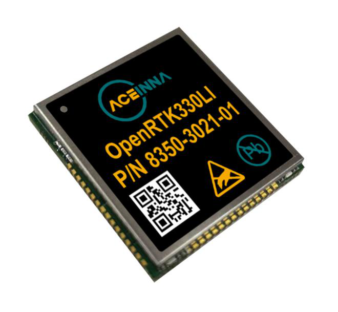
The Aceinna OPENRTK330L integrates a triple-band RTK/GNSS receiver and a triple-redundant inertial sensor to enhance the safety of autonomous systems.
Photo: Aceinna
Aceinna is now shipping its OPENRTK330L, a cost-effective module designed for developers creating mission-critical guidance and navigation systems for autonomous vehicles, including robots, drones, industrial, construction and agricultural machinery.
Aceinna designed the OPENRTK330L to replace expensive and bulky precision RTK/INS systems used in today’s autonomous systems.
The OPENRTK precise positioning engine optimizes satellite tracking and high RTK fixes rates while integrating seamlessly with Aceinna’s open-source Open Navigation Platform.
ACEINNA’s OPENRTK330L includes a triple-band RTK/GNSS receiver coupled with redundant inertial sensor arrays to provide centimeter-level accuracy, enhanced reliability and superior performance during GNSS outages. It integrates a precise 1.5-degree/hour inertial measurement unit (IMU) to offer 10 to 30 seconds of high accuracy localization during full GNSS denial.
The OPENRTK330L’s embedded Ethernet interface allows easy and direct connection to GNSS correction networks around the world. OPENRTK330L’s CAN bus interface allows simple integration into existing vehicle architectures.
The multi-band GNSS receiver can monitor all global constellations (GPS, GLONASS, BeiDou, Galileo, QZSS, NAVIC, SBAS) and simultaneously track up to 80 channels. The module has RF and baseband support for the L1, L2 and L5 GPS bands and their international constellation signal equivalents.
By integrating a triple-redundant IMU array, the OPENRTK330L is able to recognize and utilize only valid sensor data, ensuring high-accuracy protection limits and certifiability under ISO26262 standards. ACEINNA’s triple redundant 6-Axis IMU array uses a total of 9 accelerometer and 9 rate gyro channels.
The OPENRTK330L is supported by ACEINNA’s Open Navigation Platform, allowing custom-embedded application development on top of the positioning engine and dead-reckoning algorithms.
OPENRTK330L hardware also includes Ethernet, UART, SPI and CAN interfaces for versatile integration into a host system. Additional specifications include operating temperature range of -40C to +85C, and qualification to standard automotive shock and vibration levels.
StreetDrone published a report titled “Putting Safety First in Autonomous Vehicles.” The report is designed for anyone interested in the development of autonomous vehicle technologies, especially public transport and delivery companies, civic authorities and universities.
According to StreetDrone, the report contributes to the connected and autonomous (CAV) industry safety debate, as well as adds perspective to conventional CAV safety wisdom.
The purpose of the 30-page report is to make an experience-based contribution to the safety debate to enable the CAV industry to accelerate corporate, institutional and public confidence in self-driving technology, so the benefits of new autonomous services can be realized more quickly, StreetDrone said.
The report is based on the company’s experience in operating autonomous vehicle trials in urban environments, including those with high population densities and complex infrastructures. It also covers other areas for the safe operation of autonomous vehicles, including the definition of a safe operating environment, minimum operating standards for safety drivers, and a set of open data protocols for effective error tracking and rectification.
“While we’ve had to make some changes to our operations due to COVID-19, we’ve also had the opportunity to write our Safety Report based on the experience of building and running autonomous vehicles over the past three years of StreetDrone’s operations,” said Mike Potts, CEO of StreetDrone. “This experience spans the full stack of AV disciplines, from hardware and mechanical design through to AI and software, as well as a deep insight into city centre public highway trials. For an organization focused on ‘zone 1’ urban trials, we have necessarily been safety-led, so our report encapsulates much of this knowledge. We believe that industry collaboration and knowledge-sharing are essential prerequisites for CAV technology to achieve wide-scale adoption, and we’re therefore delighted to make our own contribution to this growing body of knowledge.”
StreetDrone’s own hardware platforms range from the L7e class Renault Twizy heavy quadricycle to the flexible Nissan eNV200, which comes in taxi, delivery van or 7-seater passenger variants.
Why do we keep hearing about unmanned aircraft all the time, almost everywhere? Fortunately, the buzz has gone beyond next-door neighbors flying dangerously close to your roof or hovering annoyingly around a living room window, and incidents of UAV incursions shutting down airports seem to be getting fewer — improved enforcement and higher penalties may be slowing down these incidents.
Now, UAV users are taking on productive, innovative tasks that couldn’t previously be done, or finishing projects surprisingly quickly and more affordably than ever before, with drones built or adapted for new applications. And equipment manufacturers are creating new sensors customized for use on drones.
Commercial, integrated GNSS/inertial sensors are available that have extremely high performance — previously only available with expensive mil-spec electronics — but in lightweight, small packages, supported by real-time kinematic (RTK), precise point positioning (PPP) corrections or post-processed kinematic (PPK). UAVs carry still, video and multi-spectral cameras generating automatically geocoded outputs, ready for post processing into multi-layered formats — virtually everything a customer could ever dream of having. And lidar sensors enable drones to build accurate models of everything they overfly.
Drones originated largely with military forces. Originally used for forward intelligence gathering, UAV tasks have multiplied and substantially expanded in scope.
Commercial industries were quick to realize the benefits. Before drones, the cost of many tasks done manually would be prohibitive and too time-intensive. Fast, affordable data collection now allows us to quickly tackle and solve many problems.
UAVs can pre-survey large, previously inaccessible tracts of difficult terrain, collect detailed visual representations of entire cities, monitor and support crop growth, or even survey underwater terrain using lidar. UAVs provide crop-growing support by flying autonomous patterns and spraying fields with pesticides or fertilizer. They also are being called into service to spray villages with disinfectant to control the spread of coronavirus, and to survey England’s beaches to monitor coastal erosion.
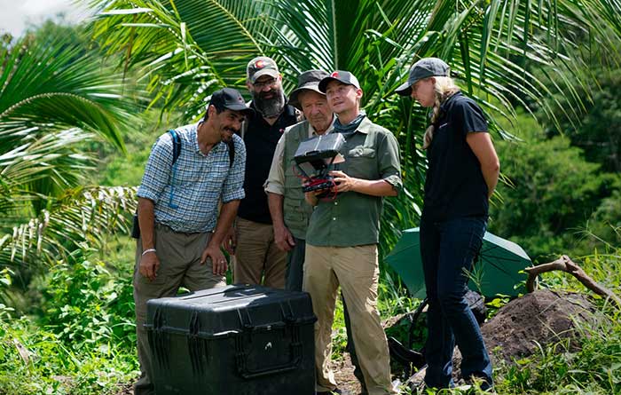
PrecisionHawk’s Jaymie Young and Matt Tompkins fly a UAV with the hosts of History Channel’s “Lost Gold of World II” in the Philippines in late 2018. (Photo: PrecisionHawk)
The collection of about 300 giant geoglyphs known as Nasca Lines were etched into the ground in the Peruvian coastal plain 2,000 years ago by the Nasca culture in South America. They depict various plants, animals, and shapes and are so large that they can only be fully appreciated when viewed from the air. Unlike the Nasca Lines, most archaeological sites are hard to see from the air, especially those deep under thick jungle vegetation, as in the lowlands of northern Guatemala. Here, lidar’s ability to penetrate foliage makes it the ideal tool for archeological exploration. At the same time, the lack of infrastructure, including airports, makes UAVs the platform of choice for many such projects.
Challenges for lidar in archaeology
Operating aerial lidar for archaeology in a jungle environment presents four challenges. The biggest one is penetrating the canopy. “Typically, the sites that they have been exploring lately have been quite overgrown, and disguising what has been there for a long time, to the extent that even someone walking on the ground has not been able to see the scope of the site,” said Paul LaRocque, senior scientist at Teledyne Optech. Penetrating multiple layers of vegetation requires a minimum of two lidar returns. For heavily vegetated environments, Matt Tompkins, director of Flight Services at PrecisionHawk, recommends a five-return system.
The second challenge is ground-truthing the data collected, explained Thomas Garrison, assistant professor in Ithaca College’s Department of Anthropology. “Even though we digitally removed the forest, it is still there, of course.” For example, it is hard to confirm long roads between sites, because they run beyond a ground observer’s field of vision.
The third challenge is acquiring a GPS signal. “In the tropical environment, a UAV needs to return to its take-off site very precisely,” Garrison explained. Finally, jungles put a twist on the familiar trade-offs between fixed-wing and rotary-wing UAVs: “A fixed-wing UAV will cover a greater area, but you may not have enough space for it to take off where you want to fly your lidar and may not be able to recover it,” Garrison said.
Making lidar an effective tool for archaeology required the development of sensors with very high pulse repetition frequencies (PRF) and with multi-look angles, which better penetrate the canopy to reach the ground and any structures, LaRocque explained.
Manned aircraft vs. UAVs
Archaeology missions need aerial lidar sensors with sufficient peak power from each pulse to reach the ground after much of it is absorbed or reflected by the canopy. In this respect, manned fixed- and rotary-wing aircraft have an advantage over UAVs because they can carry larger sensors with a higher peak power. Plus, they can cover much larger areas per flight. “This is important because archaeologists have been finding that [areas of interest] are much bigger than they ever imagined,” LaRocque said.
Finally, forests and jungles make it challenging to find open areas for launching and landing UAVs and flying them by line of sight. “Where do you stand to see the UAV above the canopy?” For these applications, LaRocque said, manned aircraft probably fly just 500 to 1,000 meters above ground level, “because they are not out for high survey efficiency but for penetration to the ground.”
Tompkins, whose company has conducted many missions in jungle environments and other remote places, takes the opposite view. Archaeology constantly presents new challenge and “takes you to some pretty crazy places,” he said and UAV lidar “allows archaeologists to access information that would otherwise be too difficult or dangerous to access.” In the projects on which PrecisionHawk has worked in heavy jungle, it has seen “excellent penetration through heavy jungle canopy, which gave us access to ground-level data,” he said.
Logistically, Tompkins pointed out, UAVs are “significantly easier and safer than manned aircraft” in remote areas with little access to airport infrastructure, air traffic control, and any sort of emergency services. A team with a UAV can mobilize and travel quickly. Where there is no electricity to recharge the UAV’s battery, the team will bring a generator.
Positional accuracy
Archaeological applications do not require survey-level positional accuracy. Archaeologists only need to be able to locate on the ground features that they identify in the 3D lidar point cloud. “We use Trimble Juno 5s, so that we can load the lidar data directly onto their screens,” Garrison said. “If we get near a structure, we only need to take a point. We don’t even need to find base stations and do corrections afterward. We can manually correct the points based on where they were on the structures.”
Ancient structures are rarely in the areas with the thickest, nastiest vegetation, which are usually low-lying areas, Garrison said. However, those areas might reveal other items of cultural interest, such as agricultural fields. “In the lidar data we have, we are seeing that ancient societies were terraforming their entire landscape, so everywhere you go there is something to check or confirm.”
Missions
In 2018, PrecisionHawk conducted an archaeological project in a remote jungle in the Philippines for a History Channel show called “Lost Gold of WWII.” Show producers were trying to find where Japanese troops might have stored gold stolen from the Philippine government.The team flew lidar on a UAV to identify roads or other manmade structures that could help them identify possible hiding spots in areas pinpointed through historical documents, Tompkins recalled.The PrecisionHawk team produced a colorized lidar data file in the jungle that the producers used on the program.
The largest lidar acquisition for archaeological investigations in the world is the Pacunam Lidar Initiative (PLI), a consortium of scholars funded by the Guatemalan foundation Pacunam (short for Fundación Patrimonio Cultural Y Natural Maya). So far, the PLI has scanned about 7,000 square kilometers in the lowlands of northern Guatemala.
Garrison is one of three principal consultants for the foundation. “Lidar has a huge impact in archaeology under tropical forests because you get more bang for the buck in terms of peeling back the forest and revealing the preserved ancient landscapes underneath,” he said. “We’ve been working on these data since we first flew in 2016 with the National Center for Airborne Laser Mapping in Houston. We published preliminary results in Science in 2018.” In the massive PLI project, “Instead of just single sites, we can see broad trends across huge areas.”
The first phase of the Pacunam lidar initiative covered 2,100 square kilometers in northern Guatemala in 10 different polygons of data acquisition. “We found that there were 60,000 more structures in these areas than we knew about before,” Garrison said. This raised the question of how so many people could feed themselves. The lidar data revealed that they had used huge swampy areas as agricultural fields. It also revealed many road systems between and within these sites and many defensive earthwork features of military engineering for warfare distributed along the valleys.
“All of that changed our view of what this ancient landscape looked like,” Garrison said. In the summer of 2019, the project flew another 5,000 square kilometers and is now analyzing the data, which shows “a complete picture of an ancient culture’s impact on the landscape,” Garrison said. “When you think of ancient Rome and everything that they had, you can’t really see everything because modern Europe is there. But here we have all this stuff preserved under the jungle in a way that is letting us see the totality of an ancient culture.”
Discoveries made with UAVs
• Using UAV lidar, the Crow Canyon Archaeology Center and the Canyons of the Ancient National Monument were able to map an 800-year-old Pueblo site at Sand Canyon, Colorado, and discover previously undocumented structures. UAV experts from Caddis Aerial and Routescene conducted the survey using a Velodyne HDL32 lidar scanner on a DJI M600 Pro UAV flying at 40-meter altitude relative to the take-off point. They then processed the point cloud, consisting of 3.2 billion points, using Routescene’s LidarViewer Pro software and created a digital terrain module at 400 points per square meter.
• A hexacopter built with DJI technology, flying 20–60 meters above the ground, enabled Isabelle Heitz of AirD’éco to map several ancient sites, including the microtopography of an ancient theater covered by woods in the center of Soissons, a town in eastern France, and a fortified town of the Gallic age, now covered by thick woods.
• Using Google Earth, satellite imagery and low-flying UAVs, archaeologists Sarah Parcak and Christopher A. Tuttle discovered a previously unknown monumental structure that had been hidden in plain sight only half a mile from the World Heritage site of Petra, Jordan.
Photo: Joel Papalini/iStock / Getty Images Plus/Getty Images
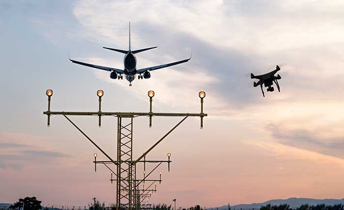
Airports are extremely congested spaces, both on land and in the air, making it difficult to conduct surveys that provide insights into their continued monitoring and maintenance.
UAVs create the opportunity to survey such sites safer and faster, reducing disturbances to everyday operations while collecting a level of detail unparalleled by conventional surveying techniques to locate and accurately capture areas in need of maintenance and management on airport runways.
Following several drainage and grading issues throughout a 650-acre airport, Texas-based civil engineering company Gessner Engineering was contracted to provide surveying services to identify the most problematic regions.
The team had to conduct the survey with minimal impact on runway operations. By coordinating with the airport’s air traffic controllers, the team planned a 6–8-hour flight window, with just a few pauses for ongoing traffic, while the airport operated as usual.
Before the flight, the surveyors used senseFly eMotion flight-planning software to carry out pre-flight risk assessments and plan flights. During the survey, four 20-minute flights were completed with the senseFly eBee fixed-wing drone. With its fully autonomous and easy-to-use aerial mapping capabilities, the eBee was able to capture the high-resolution aerial photos needed to map the entire airport. The data was processed using Pix4D Mapper to generate a topographic model including a point cloud with a ground sample distance of 1.5 inches.
The point cloud was so comprehensive, it brought attention to four more areas with drainage issues, providing a level of detail that would not have been possible using only a ground GNSS base station. The UAV survey took one day, compared to four weeks for traditional surveying. This cut the project time in half and significantly reduced disturbances to airport operations.
“The savings in manpower with the shorter surveying time, accurate data retrieved, and the additional drainage issues identified demonstrate the value of drones, as an enabler of solving complex challenges in congested airspaces, especially where time is limited,” said Troy Hittle, general manager, North America, SenseFly. “The success of this project by using UAV equipment has offered new possibilities to both Gessner Engineering and the future of aviation maintenance.”
The Edge1 system by Skycatch is a combination GNSS base station and drone data-processing unit that delivers high-accuracy maps and point clouds in minutes.
The high-performance built-in Nvidia TX2 Mobile GPU enables both maps and point-cloud processing locally within 30 minutes, as well as running artificial intelligence (AI) tasks in real time.
The base station of the Edge1 uses a Swift Navigation dual-frequency GNSS real-time kinematic (RTK) receiver. The receiver supports signals from GPS, GLONASS, BeiDou and Galileo, enabling reliably fast centimeter-level accuracy globally even in remote locations, with reliable 5-centimeter accuracy.
Users of the Edge1 system can process and receive their maps in the field, without the need for internet connectivity to process data. The system automatically generates 2D maps and 3D data, with the capability to download and use them in Skycatch’s Data Hub, as well as commonly used programs like Civil 3D, BIM360 and others.
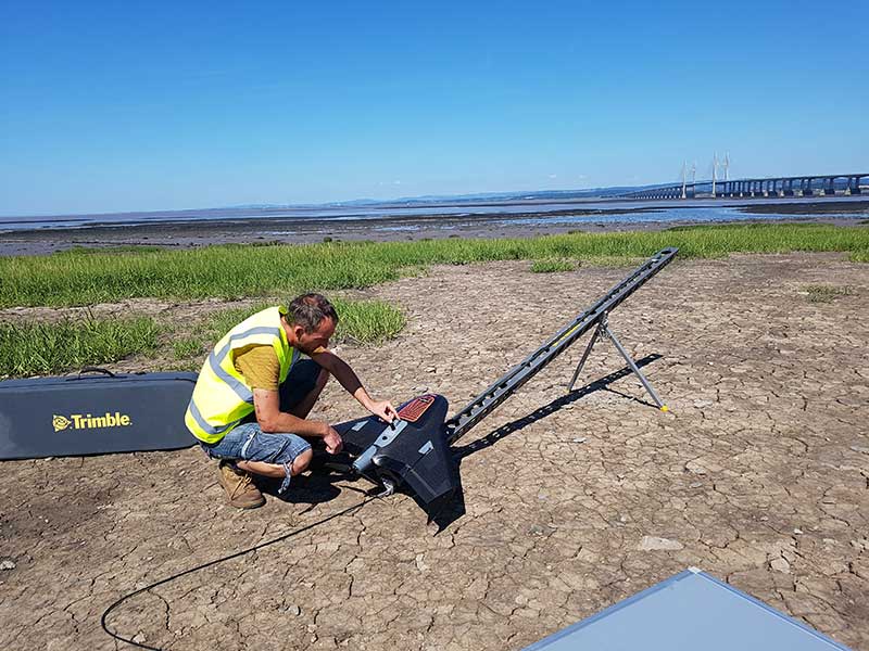
Prepping for flight: Andreas Garbe, AgSurvey, sets up the UX5 HP for a topographic survey at Severn Beach, a village in South Gloucestershire. (Photo: Trimble)
Based in Bristol, AG Surveys has been collecting topographic beach surveys around the country as part of England’s Environment Agency’s coastal monitoring campaign.
In the first integrated approach of its kind in the program, AG Surveys uses the Trimble UX5 unmanned aerial system (UAS) equipped with a Trimble/Applanix GNSS receiver along with photogrammetry software. The UAS-based system has not only confirmed its viability for coastal monitoring, it has been bringing new business opportunities ashore since 2017.
For each beach, AG Surveys must provide one baseline survey based on a 5-meter grid with a height accuracy of 3 centimeters. Also required is a series of profile line surveys. Profile surveys follow pre-defined lines set every 50 meters from the back of the beach to the low tide line, with GNSS measurements taken within 10 centimeters of each side of the line.
Crews typically cover 3 square kilometers a day, flying four to five Delair drone flights at an altitude between 100–120 meters, at speeds of 80 kph and a lateral overlap of 80%. To ensure the reliability and accuracy of the UAS data, they use a minimum of 10 ground control points (GCPs) for each flight block and measure each target’s position with a GNSS receiver.
Once flights are complete, the team imports into Trimble Business Center (TBC) the flight and GNSS data and the base station survey data. Using both on-board GNSS positioning data and the ground control data, they process precise, short baselines between the base station and each photo point. All images are then integrated into Trimble’s Inpho UASMaster software to create a dense point cloud and a seamless orthophoto of the entire area of interest. (UASMaster is now integrated into the TBC Aerial Photogrammetry Module). If needed, they can also use UASMaster to produce a seamless, georeferenced orthophoto directly from the point cloud.
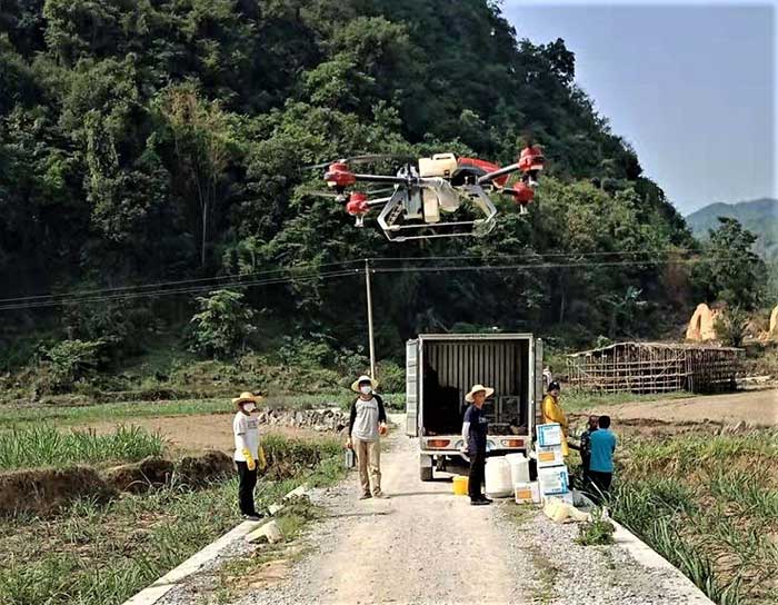
XAG introduces agricultural drones for farmers in China. The XMission drone can reduce costs on fertilizer, pesticides and other treatments. (Photo: XAG/Unicore)
Pesticides, fertilizers and water are the most important means to enhance agricultural crop production.
The prevalent infestation of fall armyworm in China has resulted in reduced yields, threatening food security and the livelihood of smallholders. It’s impractical to conduct manual spraying over farmlands larger than 5 hectares, and this also runs both the risk of wasting large amounts of pesticides and chemical poisoning.
Given the situation, smart agriculture devices such as drones have come in handy for fixing these problems, with minimal environmental impacts. In China, professional farmers and agricultural service providers have already harnessed existing drone technology to conduct appropriate chemical sprays to safeguard the country’s crop production.
The XAG XMission drone has centimeter-level navigation and can operate fully autonomously over complex terrain and easily adapt itself to different spraying conditions for various crop species. Farmers are therefore relieved from much physical effort while no longer risking their health in the battle against fall armyworm.
Equipped with Unicore’s high precision dual-antenna GNSS module (UM482), dual RTK plus GNSS positioning system, real-time centimeter-level flight positioning provides reliable data support in various air tasks. XAG’s drone carries a 4G communication module connected to the XAG Cloud RTK network in order to immediately start missions without setting up portable ground RTK bases.
Unicore UM482. Unicore’s GNSS high precision module (UM482) provides centimeter-level accuracy real-time positioning, with 0.2°, 1-meter baseline course information. UM482 supports single-module dual-antenna signal access and has a dual-RTK engine, enabling high-precision, high-reliability directional heading and dual-RTK real-time positioning, with each RTK engine calculating position independently. This receiver meets the flight needs of different types of UAVs for many different scenarios.
Virus Fighting. XAG’s drones have also joined the fight against the spread of the coronavirus. In Feburary, XAG announced a 5-million-yuan fund for coronavirus response, to be put toward aerial disinfectant sprays to curb the spread of the virus in rural areas. The company’s fleets were used in China’s Shandong province on Jan. 28, where they reportedly disinfected a local community of more than 300,000 square meters in less than 4 hours.
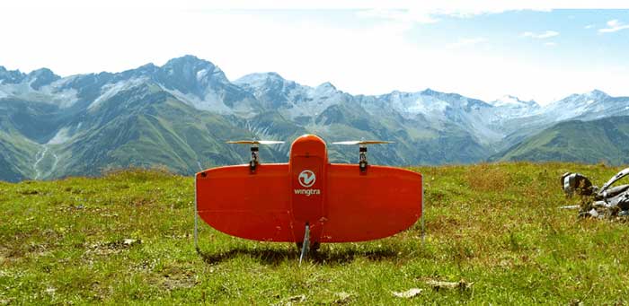
Site-survey preparations for a windfarm of 20 300-foot tall wind turbines might have been quite complex for a location in a 2,500-foot-high valley in the Swiss Alps.
However, the contractor decided to use a drone with vertical take-off and landing (VTOL) capability supplied by Wingtra to speed up the work and produce highly accurate geo-referenced data. Although multirotor drones are normally used for detailed survey work, they can cover much less area than fixed-wing drones during the same flight time. Fixed-wing drones can fly longer, farther and carry more weight.
Multicopters tend to carry more expensive, higher accuracy sensors because the sensors are not subject to potential damage from fixed-wing belly landings. Wingtra solved this problem by developing a drone with vertical take-off, the ability to transition to horizontal flight and to then land upright. When equipped with heavier, more accurate sensors, longer and more complex surveys are possible.
The Septentrio AsteRx-m2 was also chosen for the WingtraOne drone. The AsteRx-m2 is a high-precision, multi-frequency, four-constellation, PPK, low weight and power GNSS module. The low-latency AsteRx-m2 works for both rotorary- and fixed-wing UAV applications.
The WingtraOne VTOL drone is able to cover 400 hectares (an area of around 570 football fields) in one 55-minute flight. The resulting mapping accuracy is as high as 1.27 centimeters (0.5 inches). The drone was equipped with the full-frame 42MP Sony RX1RII camera, with seven ground control points for increased accuracy.
The WingtraOne took off vertically and transitioned to fly horizontally at the planned 1,500-foot altitude. Each flight took about 20 minutes to plan and involved 30 minutes of flying time. The flights covered a total area of 1,100 hectares — each flight was 200–300 hectares.
Aerial data collected from the site was converted to 3D models that allowed visualization of planned roads and wind-turbine locations in the wind farm. The data-collection workflow only took 4 hours rather than the days required with traditional surveying. Use of high-end sensors ensure survey-grade imagery and accuracy — in this case, the engineers obtained an accuracy of 3–4 cm.
Flying in an area as difficult as the Swiss Alps to collect aerial data has been one of Wingtra’s most complicated challenges. By reducing costs and the time to complete the survey and evaluation of the proposed site, the customer was able to maintain the overall wind farm project timelines.