Drone-maker DJI has filed an 89-page formal comment urging the U.S. Federal Aviation Administration (FAA) to allow drone pilots to choose which method of remote identification to use with their drones.
DJI’s filing includes an independent economic study that concludes the FAA’s Remote ID proposal would prove nine times as costly as the FAA’s estimates, imposing $5.6 billion worth of burdens on society over the next decade. The analysis finds many of those costs could be obviated if drone pilots could choose between two different methods of compliance, rather than doing both as the FAA proposed.
The economic analysis was prepared by Christian Dippon, Managing Director at NERA Economic Consulting, who considered the societal costs of the FAA’s proposed rule. He concluded the average monthly cost of a remote ID network-based service for a drone user would be $9.83, rather than the FAA’s $2.50 estimate; that demand for drones would fall 10 percent if the FAA’s proposals were imposed as written; and that total costs over 10 years would be $5.6 billion instead of the FAA’s $582 million estimate.
“We have known for years that Remote ID will be required by governments worldwide and will provide members of the public with confidence in productive drone uses, but the FAA’s deeply flawed proposal poses a real threat to how American businesses, governments, educators, photographers and enthusiasts can use drones,” said DJI vice president of Policy & Legal Affairs Brendan Schulman. “We hope our detailed economic analysis and comments, as well as tens of thousands of comments from other concerned parties, will encourage the FAA to develop a more risk-based, balanced and efficient remote ID rule, so our customers and the entire industry are not hurt by the final outcome.”
Remote ID allows authorities to identify and monitor airborne drones in near-real time, so they can see the location of the drone as well as a serial number to identify its owner. Congress tasked the FAA in 2016 with exploring consensus-based technology standards that could lead to Remote ID regulatory solutions.
In late 2019, the FAA proposed that almost all drones should broadcast that information directly to nearby receivers, as well as transmit it over wireless networks to a service provider’s database, with an anticipated monthly subscription fee for that service.
DJI and many other drone stakeholders have instead said the FAA should let drone operators choose whether to use broadcast or network solutions for Remote ID. Any new Remote ID rule is unlikely to take effect before 2024.
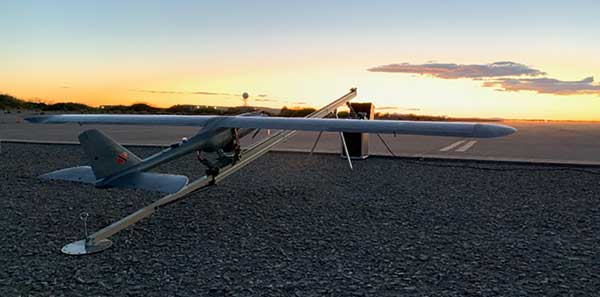
On Feb. 3, drone company Quaternium broke its own record for long flight time with a hybrid-fuel electric drone.
The Quaternium HYBRiX UAV took off at 08:52 a.m. in Valencia, Spain, and landed at 17:02 p.m., performing a stationary flight of 490 minutes.
The new endurance record of 8 hours and 10 minutes of non-stop flight time was accomplished with an experimental version of the company’s HYBRiX 2.1 drone, which carries 25 kilograms of maximum take-off weight.
Six years ago, the startup Quaternium developed its first hybrid fuel drone, inspired by hybrid cars from the automotive industry.
In 2015 the company flew its hybrid drone, the multirotor HYBRiX, for 3 hours and 10 minutes. According to the company, Hybrid multirotors multiply flight time more than 10 times compared to electric solutions.
The company has published a flight video with the demonstration of the record.
Most multicopter drones provide flight times of 25 to 40 minutes, with the pilot needing to carry multiple batteries into the field.
The HYBRiX project is supported by the European Union through its Horizon 2020 innovation program, which fosters disruptive projects in innovation, excellent science and industrial leadership. The project has received awards from institutions such as AUVSI, CDTI and the Spanish government.
The Quaternium team was motivated to develop a long-endurance drone because it will help first responders and and firefighters to identify hot spots and search for survivors in the event of a catastrophe, the company said in a press release.
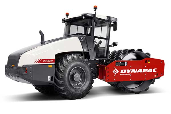
Dynapac and Trimble are partnering to develop commercial-ready autonomy functionality for Dynapac soil rollers.
The companies first demonstrated automation of the soil compaction process at this week’s ConExpo 2020 in Las Vegas, and plans another demonstration during the Trimble Dimensions User Conference Nov. 2-4 in Nashville, Tennessee.
The Dynapac CA3600PD single-drum vibratory roller. (Photo: Dynapac)
Dynapac’s “Road to Autonomy” was launched with the introduction of Seismic Soil Rollers in 2019. The Dynapac-exclusive Seismic technology takes the guesswork out of the equation for operators, regarding soil type or frequency settings, the company said.
Dynapac Seismic monitors the soil properties and automatically adjusts the frequency of vibration for optimal compaction and energy efficiency. The Active Bouncing Control System automatically cuts off the vibration of the drum when the material reaches maximum compaction characteristics.
The next step on the “Road to Autonomy” is automatic steering and speed functions on the roller. The operator/site manager can use the machine to map the boundaries of the area to be compacted.
Once the machine is placed in autonomy mode, the system will take over the controls for steering and speed. This functionality will be shown at the Dynapac and Trimble booths during ConExpo 2020.
By automating these functions, operator skill gaps can be bridged, while consistent speed and steering improve compaction quality results.
The autonomous solution is built on Trimble’s control platform and utilizes Trimble’s field-proven positioning technology. Compaction documentation systems, such as Dyn@lyzer or Trimble CCS900 Compaction Control System, work together with automatic speed and automatic steering to provide documentation of the improved quality.
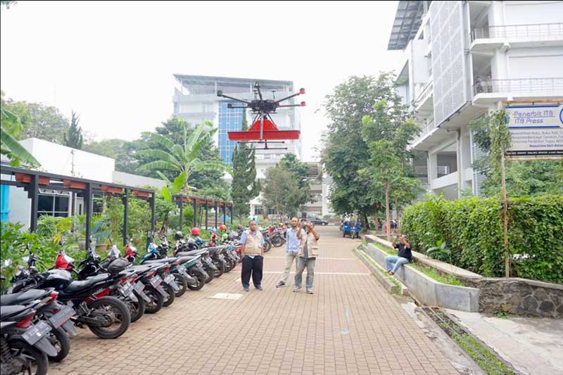
Terra Drone Indonesia, a group company of Japan-based Terra Drone Corp., has successfully completed a pilot project at the Bandung Institute of Technology (ITB) in Indonesia. The project included flying a drone equipped with a Ground Penetrating Radar (GPR) system over the campus to map tunnels and underground utilities.
The drone data was then processed and compared with the infrastructure records of the university by geophysicists, who determined the underground assets were accurately and precisely mapped, Terra Drone Indonesia said.
According to Terra Drone Indonesia, the combination of GPR and drones opens up new potential for the use of unmanned technologies in areas that are traditionally challenging and unsafe, such as post-blast areas in open-pit mines. A GPR drone also could be used to locate underground pipes, map the conditions of the assets and detect hazards like pipeline leaks.
“The conventional GPR method requires field personnel to go to the field and carry GPR tools to conduct surveys,” said Michael Wishnu Wardana, managing director at Terra Drone Indonesia. “But this method has its own dangers because not only are some areas unsafe and difficult to reach, but also because severe weather conditions in the field can hamper workers from carrying out their jobs diligently. GPR drones, in contrast, have emerged as a much safer and efficient surveying solution.”
Terra Drone Indonesia worked on this project in collaboration with PT Airborne Geophysics Indonesia and the Geophysics Laboratory at ITB. TerraDrone Indonesia has worked with ITB in the past as well, validating Terra Lidar’s topographic mapping capabilities at ITB’s Jatinangor Campus.
A roundup of recent products in the GNSS and inertial positioning industry from the March 2020 issue of GPS World magazine.
OEM
NavIC modules
Support both L1 and L5 bands
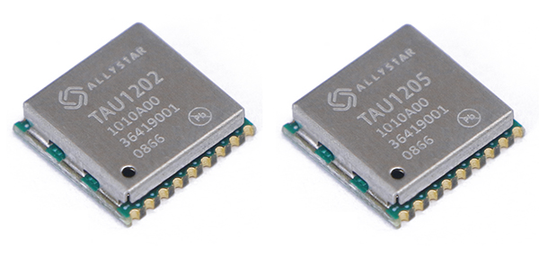
Photo: Allystar
The dual-band multi-GNSS modules TAU1202 and TAU1205 support both the L1 and L5 bands to enhance sub-meter positioning accuracy. Constellations received include GPS, Galileo, GLONASS, BeiDou, QZSS and NavIC. Besides the L1 band, TAU1202 and TAU1205 also support L5/B2a/E5a, which are expected to have lower noise and significantly reduced multipath mitigation because of the higher chipping rate of L5 signals relative to L1 C/A code. TAU1205 supports NavIC (IRNSS), improving navigation in India and the Middle East. Powered by the Cynosure III GNSS chipset and with built-in low-noise amplifier and surface acoustic wave (SAW) filter, TAU1202 and TAU1205 provide higher sensitivity, ensuring exceptional acquisition and tracking performance even in weak signal areas.
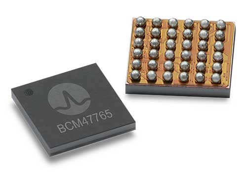
The BCM47765 dual-frequency GNSS module is capable of using the BeiDou-3 constellation’s B2a signals (the Chinese indicator for L5). It can track 30 new L5 signals (60% more) with a significant impact on accuracy. End users will experience much higher reliability of the submeter accuracy inherent to dual-frequency L1/L5. The enhanced L5 signal improves the accuracy of GNSS in an urban scenario by mitigating reflections from nearby buildings (multipath). It also improves GNSS in an open-sky scenario, allowing for submeter accuracy. Second generation dual-frequency GNSS will enable lane-level driving navigation, allowing applications to know in which highway lane a vehicle travels.
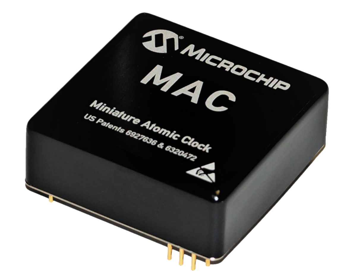
The MAC-SA5X miniaturized rubidium atomic clock is a high-performance atomic clock that delivers a wide thermal range, critical performance improvements and other enhancements over previous clocks. The MAC-SA5X produces a stable time and frequency reference that maintains a high degree of synchronization to a reference clock, such as a GNSS-derived signal. Its low monthly drift rate, short-term stability and stability during temperature changes allows the device to maintain precise frequency and timing during extended periods of holdover during GNSS outages or for applications where large rack-mounted clocks are not possible. Operating over a temperature range of –40 to +75 Celsius, the MAC-SA5X is designed to quickly achieve atomic stability performance with a fast lock.
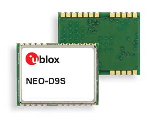
The NEO-D9S GNSS correction data receiver module provides an affordable approach to bringing centimeter-level accuracy to GNSS receivers. The NEO-D9S receives corrections from correction service providers broadcast on the L-band (1525–1559 MHz). A host processor can then decrypt this correction data and provide it to a high-precision GNSS receiver, combining corrections directly with readings from the satellite constellations to enable much more accurate position readings than those offered by GNSS signals alone. Use of the NEO-D9S will also increase the availability of high-precision GNSS positioning data in areas with limited connectivity and reduce the amount of cellular data consumed by positioning receivers. Expected customers are Tier 1 and OEM carmakers, industrial system integrators, and any other applications that rely on very accurate positioning at low cost. The NEO-D9S module is a correction-only receiver. Based on the latest u-blox ninth-generation (D9) platform, it will integrate easily with the u-blox F9 RTK GNSS receivers from u-blox, or can be used as part of a modular product roadmap.
The Qualcomm Snapdragon 720G, 662 and 460 enable enhanced user experiences across connectivity, gaming and entertainment. The new mobile platforms support dual-frequency (L1 and L5) GNSS to improve location positioning accuracy and robustness. The system-on-chip solutions also support NavIC. For the first time on mobile, the Qualcomm Location Suite supports up to seven satellite constellations concurrently, including NavIC.
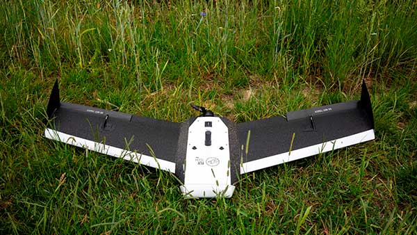
Dedicated to surveying and agriculture, the UAV Birdie is tailor-made, combining intuitive use and high-quality data through precise sensors and GPS RTK L1/L2 onboard. Features include a 24-megapixel camera or optional full-frame 42-megapixel camera; flight time up to 60 minutes; and coverage up to 8 square kilometers in one flight. A vertical-takeoff-and-landing (VTOL) upgrade is available.
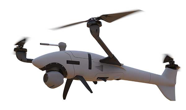
Skyfront’s Perimeter 8 drone is equipped with Silvus Technologies’ SteamCaster Radio system, a powerful user-customizable radio system for the military, police and broadcast. The new long-range drone will allow operators to inspect pipelines and other assets as well as conduct long-range surveillance missions. The octocopter can fly for five hours and travel up to 100 kilometers without losing connection from the ground station. Currently, five models are available to suit uses including mapping, lidar and medium, long, or extra-long surveillance. SteamCaster radio system uses the latest beam-forming technology, spatial multiplexing, and space-time coding to ensure the drone can be controlled in environments in which other radio systems are likely to fail. The combination of the technologies allows the range to be increased from 40% to 100%. SteamCaster comes with SteamScape, a network management interface to allow for key metrics and statistics to be viewed and collected in real time. The system also allows the drone to be overlayed onto a map showing the current location and path of the drone.
Delivers critical tools on the ground or in the air
Photo: Robotic Research
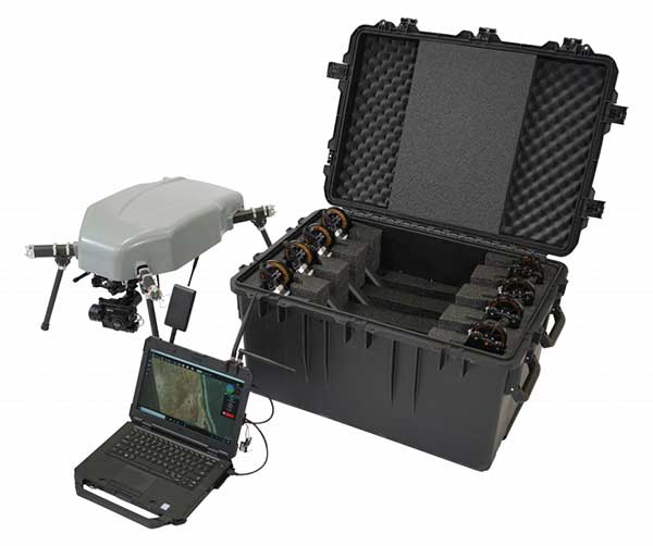
The Pegasus Mini is a smaller version of the Pegasus, a hybrid unmanned aircraft system/unmanned ground vehicle. The Pegasus hybrid UAS/UGV configuration delivers advanced GPS-denied mapping with fully autonomous high-speed flying and driving capabilities. Pegasus Mini is designed to provide the extra reach that a UAV or UGV alone cannot provide. Uses include inspection, rescue, rapid response, and applications that strongly benefit organizations in oil and gas, public transportation, law enforcement, public safety, and more.
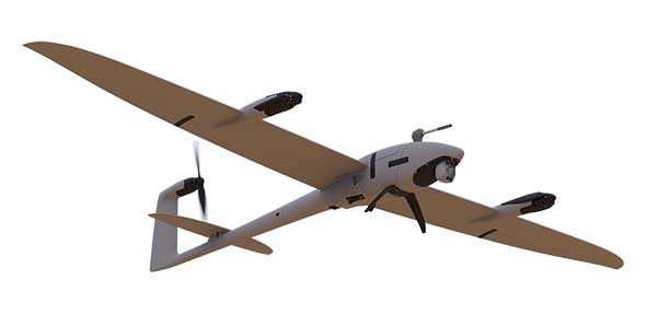
The Silent Falcon E1 UAV has completed 500 hours of successful flight testing and operations. It’s maker, Silent Falcon UAS Technologies (SFUAS), is based in Albuquerque, New Mexico. The E1 solar-electric, fixed-wing UAV is noise free, emission free, and provides long-range, low-cost intelligence, surveillance and reconnaissance (ISR) capability. It has a payload capacity of 20 pounds and a ceiling of 20,000 feet above ground level. SFUAS has an application pending before the FAA for type certification of the E1. The 500-hour milestone confirms for federal regulators that it is safe and durable. Silent Falcon aircraft have operated in eight foreign countries and are not ITAR restricted.
The High Definition (HD) GNSS cloud-based solution enables mass-market devices to achieve sub-meter accuracy across the globe. HD GNSS enables lane-level navigation, augmented reality and virtual reality. It combines precise point positioning (PPP) and real-time kinematic (RTK) positioning methods, allowing for fast convergence time, high availability and global coverage. It also supports off-the-shelf mobile devices and internet of things (IoT) trackers equipped with dual-frequency chipsets.
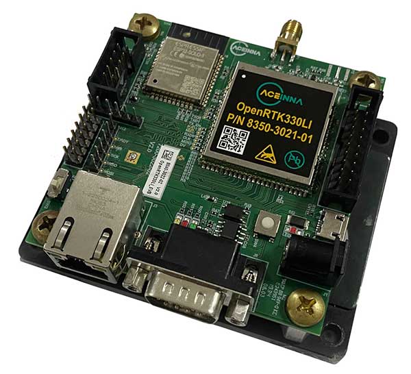
The OpenRTK330L GNSS/INS module is designed for developers creating guidance and navigation systems for autonomous vehicles, robots, drones, industrial, construction and agricultural machinery. OpenRTK330L is a low-cost, high-performance triple-band RTK/GNSS receiver coupled with redundant inertial sensor arrays to provide cm-level accuracy, enhanced reliability, and superior performance during GNSS outages. The module is aimed at automotive, robot, drone, construction and agriculture systems. The multi-band GNSS receiver can monitor all global constellations (GPS, GLONASS, BeiDou, Galileo, QZSS, NavIC, SBAS) and simultaneously track up to 80 channels. The module has RF and baseband support for the L1, L2 and L5 GPS bands and their international constellation signal equivalents.
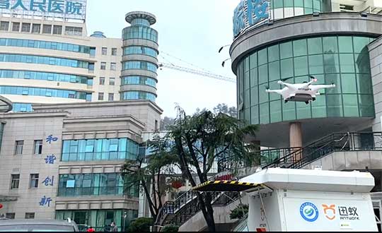
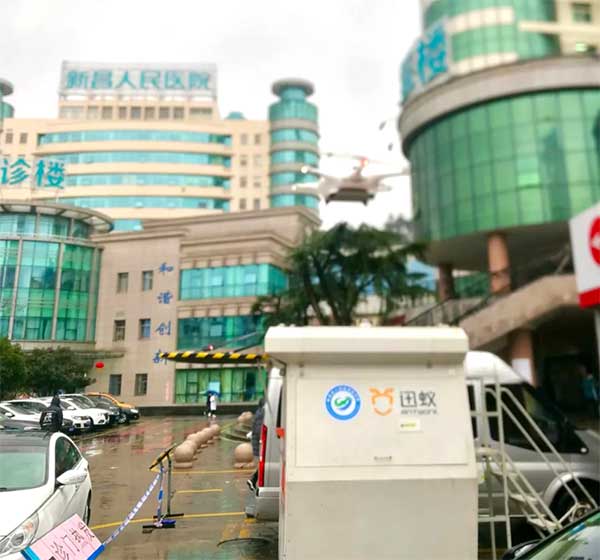
Through its group company Antwork, Japanese company Terra Drone is employing its UAV system to transport medical samples and quarantine supplies in China to fight the coronavirus.
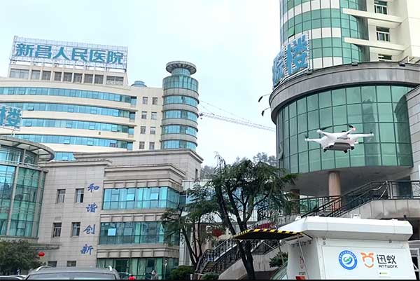
At 9 a.m. on Feb. 6, a medical delivery drone flew from the People’s Hospital of Xinchang County to the disease control center of Xinchang County, marking the launch of the first urban-air transportation channel to help to fight the novel coronavirus (COVID-19 ), a global health emergency.
Take off and landing point of Xinchang people’s Hospital. (Photo: Terra Drone)
The World Health Organization reports at least 95,270 people are infected and at least 3,280 have died. China, where COVID-19 originated, is in a tense period of epidemic prevention and control. Xinchang County is in Zhejiang province — one of the areas most severely hit by the virus.
As soon as the Wuhan quarantine began on Jan. 23, Antwork petitioned to provide drone technical support.
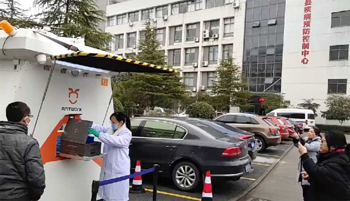
Antwork’s RA3 and tr7s drones and unmanned RH1 station are ensuring that medical samples and quarantine materials can travel with minimal risk between Xinchang County People’s Hospital and Xinchang County’s disease control center. The automatic, unmanned air delivery system significantly reduces contact between samples and personnel, as well as improves delivery speed.
Antwork branch company Aerodeli, which undertook the operation, obtained the first urban drone delivery license issued by the Civil Aviation Administration of China (CAAC) in October 2019. The sample delivery work is carried out in strict accordance with certified operation procedures to ensure the safety of medical samples during transportation.
Take off and landing point of disease control center of Xinchang County. (Photo: Terra Drone)
Using drones has increased the speed of transport by more than 50% compared to road transportation, proving to be a more efficient means of transportation for epidemic prevention and control. The drones also relieve the personnel shortage as more and more medical staff and ambulances are transferred to the front lines — making the best use of human and material resources.
After the project for Xinchang People’s Hospital was put into operation, Antwork began assisting more medical institutions in China to deploy drone transport services for the anti-epidemic effort.
A drone departs from the disease control center of Xinchang County. (Photo: Terra Drone)
New BOLT platform enables equipment manufacturers to automate outdoor jobs, adding autonomous navigation, connected sensors and real-time operations to machines.
Left Hand Robotics, a manufacturer of self-driving smart robots for commercial turf and snow, has launched BOLT, a technology platform that transforms outdoor machinery and power equipment into smarter, more efficient, ready-to-work robots.
BOLT brings autonomous navigation, connected sensors, and real-time robot operations to outdoor power equipment and machines doing repetitive jobs across the globe. Building on Left Hand Robotics’ field-proven experience with its own robot tractors, BOLT allows OEMs to launch faster, reduce R&D costs, and tap into a unified platform with navigation, sensors, controls, software and apps.
BOLT focuses on several key areas to help with machine automation, including:
autonomous navigation and telemetry
smart sensors and cameras
connected power equipment and controls
cloud-based robot operations center and apps
job planning, reporting and analysis
Because each OEM is likely to have different requirements or product needs, BOLT partners go through multiple deployment phases, including evaluation, development and deployment.
Partnering with OEMs. Left Hand Robotics soft-launched BOLT earlier this year and interest has been high from manufacturers needing more automation capabilities. The company is now collaborating with power equipment and machine manufacturers to incorporate BOLT features into their future product lines.
“Our team has learned a lot, building, testing, proving how autonomous tractors can work on tedious, dirty jobs in the real world. These are tough problems to solve and we have already invested more than 80 engineering years into the technology behind BOLT,” said Terry Olkin, CEO for Left Hand Robotics. “We’ll continue to build our own robots while offering BOLT to a limited number of OEMs in the first year.”
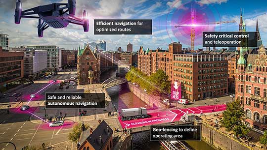
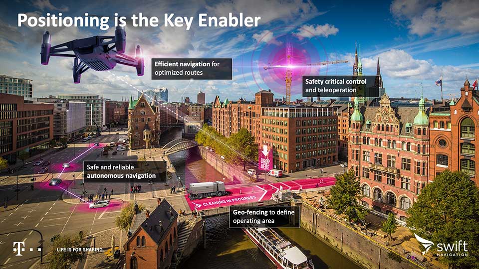
California-based Swift Navigation is partnering with Deutsche Telekom, an integrated telecommunications company based in Bonn, Germany. The partnership brings the precise positioning of Swift’s Skylark Cloud Corrections Services to Telekom’s comprehensive communications infrastructure via its new Precise Positioning product offering.
The Precise Positioning service is available across the United States and Germany, with expansion across Europe underway.
Autonomous applications. Autonomous applications, which rely on positioning accuracy, include self-driving cars, rail, autonomous robotic machine navigation, autonomous flight for unmanned aerial vehicles, last-mile delivery logistics, construction safety, and shared mobile positioning.
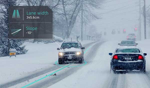
Swift and Telekom’s lane-level accurate Precise Positioning is specifically designed for level 2 and 3 automotive applications including advanced driver-assistance systems (ADAS), such as lane assist, highway autopilot, cellular vehicle-to-everything (CV2X) communications and lane level directions.
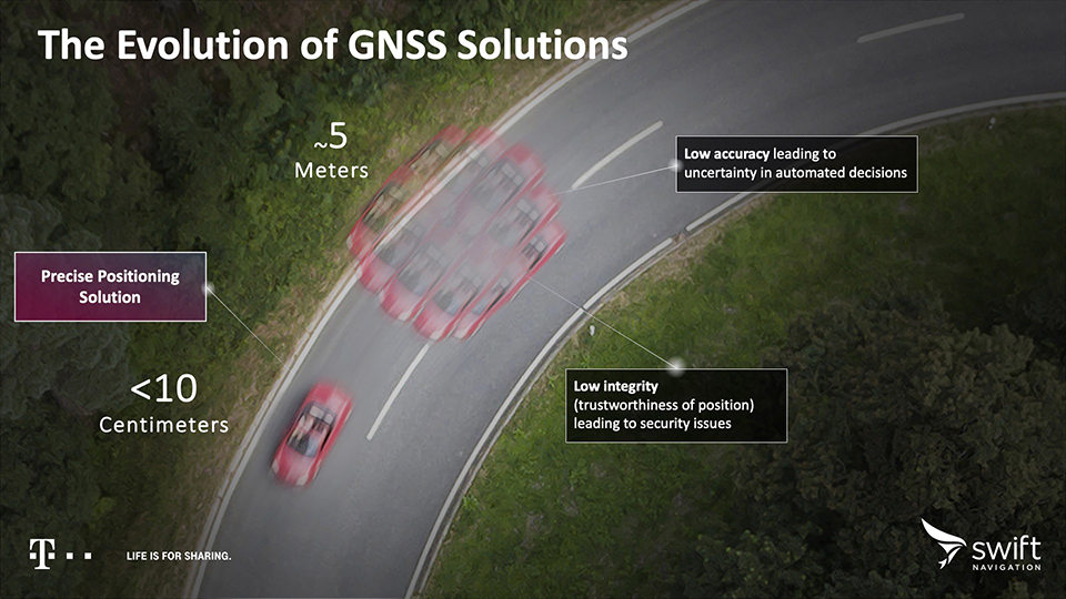
Standard GNSS positioning is accurate to three to five meters — unsuitable for autonomous systems. For higher levels of autonomous capability, high-precision localization is required to deliver accuracy down to the centimeter. This partnership brings the <10-centimeter accuracy of Swift’s precise positioning solution to Telekom customers.
Precise Positioning is a wide area, cloud-based GNSS corrections service that delivers real-time high-precision positioning to autonomous vehicles. Built from the ground up for autonomy at scale, the Precise Positioning service enables lane-level positioning, fast convergence times and high integrity and availability required by mass market automotive and autonomous applications.
Image: Swift
Hardware-Independent. The service is hardware-independent, allowing customers to choose their GNSS sensor ecosystem. It delivers a continuous stream of multi-constellation, multi-frequency GNSS corrections for a high-availability service that combines lane-level accuracy and world-class integrity at a continental scale.
“Swift Navigation is excited to continue our work with Telekom to bring Swift’s precise positioning GNSS expertise to Telekom’s broad customer base,” said Timothy Harris, co-founder and CEO at Swift Navigation. “This partnership is just the beginning of our joint service offering for autonomous vehicles across the EU.”
“Precise Positioning opens the doors to true autonomous mobility. Precise, safe and in the future also cross-national,” said Hagen Rickmann, responsible for business customers at Deutsche Telekom. “We are thus offering our customers an easy entry into the autonomous future. And we’re not just thinking of self-driving vehicles: The flexible offer is also suitable for use with drones and is even of interest to crane operators on construction sites.”
For ease in testing and integration, Swift and Telekom have created a Precise Positioning Evaluation Kit. The kit includes two workshops (onboarding and result review), testing hardware and software to connect to the Precise Positioning network for a three-month evaluation period and is available to purchase.
Livox Technology Company has introduced two high-performance, mass-produced lidar sensors, the Horizon and Tele-15, which feature a new scanning method that offers improved sensing performance at a low cost.
The lidar sensors are aimed at L3/L4 autonomous driving, smart cities, mapping, mobile robotics and more.
“The growth potential of the lidar industry has been hindered for too long by ultra-high costs and slow manufacturing rates,” said Henri Deng, global marketing director at Livox. “Livox seeks to change this by providing access to high-quality lidar systems that are easily integrated into a wide array of different use applications. Through our technology, we hope to be the catalyst for the rapid adoption of lidar in the quickly growing industries of autonomous driving, mobile robotics, mapping, surveying and more.”
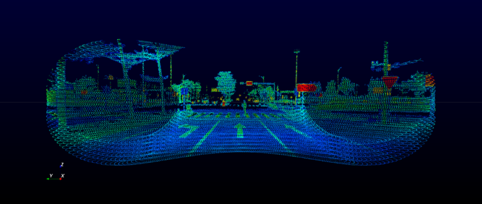
The environment scanned by a Livox sensor increases with longer integration time as the laser explores new spaces within its field of view (FOV). A Livox Mid-40 or Mid-100 sensor generates a unique flower-like scanning pattern to create a 3D image of the surrounding environment.
Horizon point cloud sample of crossroads with a pedestrian crossing the street. (Image: Livox)
Image fidelity increases rapidly over time. In comparison, conventional lidar sensors use horizontal linear scanning methods that run the risk of blind spots, causing some objects in their FOV to remain undetected regardless of how long the scan lasts.
The non-repetitive scanning method of the Livox lidar sensors enables nearly 100% FOV coverage with longer integration time.
The Horizon and Tele-15 are high-performance lidar sensors designed for L3/L4 autonomous driving applications. The Horizon has a detection range of up to 260 meters with a horizontal FOV (HFOV) of 81.7° which can cover four road lanes at a distance of 10 meters. Its FOV coverage ratio is comparable with a 64-line mechanical lidar at the integration time of 0.1 sec. Using five Horizon units enable full 360° coverage.
Made for advanced long-distance detection, the Livox Tele-15 offers the compact size, high-precision and durability while vastly extending the real-time mapping range. The Tele-15 can scan 99.8% area within its 15° circular FOV at 0.1s.
The Tele-15 can successfully detect an object up to 500 meters away. As a result, Tele-15’s performance allows autonomous driving systems to detect remote objects well in advance, providing more reaction time even at high speeds.
Two new small unmanned aerial systems (sUAS) are available to the U.S. government defense and security markets.
Auterion Government Solutions Inc. and Quantum-Systems GmbH have partnered to bring the Vector and Scorpion to market. The partnership brings together high-quality sUAS hardware with a secure, scalable, open source, operating system, Auterion OS.
Auterion OS is employed on sUAS from small multi-rotors to hybrid VTOL Group 2 air vehicles. The open-source operating system aligns with the Defense Department’s Group 1 UAS Architecture.
2-in-1 UAS
Vector and Scorpion form a 2-in-1 system kit. Scorpion is a tri-copter that can be used for dynamic urban environments and other mission sets that require a combination of maneuverability and hover to collect intelligence, surveillance and reconnaissance (ISR) data, as well as situation awareness information. If required, it comes with a tethering system to enable 24/7 operations.
By configuring the base fuselage with fixed wings and tail section, Scorpion transforms into Vector, an energy-efficient, fixed-wing VTOL for longer range, longer endurance ISR missions.
The Vector. (Photo: Quantum-Systems)
Command and control
Quantum-Systems uses a proprietary flight control stack as well as its qBase command and control software on the two air vehicles.
When the platforms are integrated with Auterion Enterprise PX4 software, Auterion Ground Station software, and the Auterion Hand-Held Ground Control Station (H-GCS) they form an open ecosystem that is aligned and integrated with DoD’s Group 1 UAS Architecture and requirements for a common Group 1 control system.
The integration enables these sUAS to be extensible, tailorable and interoperable for customers in both the U.S. defense and security markets.
“We are excited to be working with Quantum-Systems to bring forth a new, integrated, rucksack portable sUAS that we feel will transform the way our customers collect, process and disseminate ISR and Situation Awareness information, in all environments,” said David Sharpin, CEO of AGS.
“By setting up a U.S. entity, Quantum-Systems will move closer to the customer while working on setting up a large-scale U.S. production,” said Florian Seibel, CEO of Quantum-Systems.
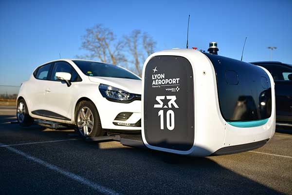
Stan servicing vehicles at the Lyon Airport. (Photo: Stanley Robotics)
Stan incorporates the Trimble BX992 dual-antenna enclosure for accurate, available and reliable localization
The Stanley Robotics team has called on Trimble to equip Stan, its autonomous parking and valet robot, with accurate localization.
To achieve centimeter-level localization, Stanley Robotics needed to combine perception algorithms and intelligent management software with reliable GNSS technology.
“The robot must move fast to handle high traffic flow and precisely to park cars as densely as possible,” said Anthony Troublé, robot team manager at Stanley Robotics. The team selected the Trimble BX992 dual-antenna enclosure and two Trimble AV59 GNSS antennas.
The BX992 is installed inside the robot and the two antennas are mounted on the robot’s head with maximum separation between them. For the robot to attain centimeter-level localization, a Trimble BX992 base and a Trimble Zephyr antenna are installed at the drop-off cabins where customers leave their cars until robots move them to a more permanent location.
The Trimble BX992 base broadcasts real-time kinematic (RTK) corrections over a Wi-Fi link to the robots.
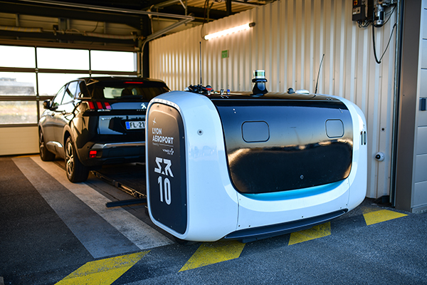
What Stan Does
Photo: Stanley Robotics
With the Stan robotic valet, passengers no longer waste time looking for a free space or trying to locate their vehicle, according to Stan’s creators. After booking their parking space in just a few clicks on the Lyon Airport website, passengers drop off their vehicle in dedicated cabins and make their way to the terminals using the shuttle bus located just a few steps away.
The robot takes care of the car, parking it in the secure car park. When they return, passengers pick up their vehicle, which is waiting for them in one of the cabins.
“The service offers security, simplicity and time savings. With this new technology, parking becomes a no-fuss experience that takes only a few minutes of passengers’ time, leaving them free to travel in a relaxed state of mind,” Stanley Robotics said in a press release.
The system also constitutes a new way of arranging vehicles in a car park and makes excellent use of space since cars can be parked in dense blocks.
In addition, the robot uses two lidar scanners and four cameras. Stan relies on lidar-based simultaneous localization and mapping (SLAM) techniques to locate the robot and build a map. The lidar-based SLAM system is always running and is fused with the GNSS localization and odometry.
“The lidar is mostly critical in the cabins where the GNSS availability and reliability is not sufficient,” Troublé said. “The full integration with our localization system, especially the transition from indoor-to-outdoor when the robot enters a cabin was a challenge. We have tuned and improved our localization fusion algorithm to get the best out of each component and deliver a consistent confidence index.”
Stan is equipped with three levels of safety to ensure operational effectiveness.
First, Stanley Robotics continuously monitors the accuracy, availability and consistency of the RTK GNSS, SLAM and odometry localization signals. “If these signals are too inconsistent or if the overall confidence is too low, the robots are stopped and a site supervisor is alerted,” Troublé said.
Further, the site is monitored through lidars and cameras on the robot to prevent any collision with obstacles.
Finally, a trained Stan maintenance worker is assigned to every parking lot. These individuals wear a safety badge. Every robot is equipped with a safe-stop feature that will trigger if the operator gets within a defined proximity to the robot.
The first outdoor car park managed by robots opened to the public in 2018 at Lyon Saint-Exupéry airport. Since testing started in 2017, four Stan robots are now fully operational in the Lyon Saint-Exupéry airport car park, which can accommodate up to 500 vehicles.
Stanley Robotics announced in January 2019 that they will open 2,000 spaces at Lyon in the summer of 2020. The airport is looking to eventually expand this system to up to 6,000 spaces in total.
In 2019, Stanley Robotics signed a contract with Gatwick Airports, the first U.K. airport to use robots that valet park passengers’ cars. The Stanley Robotics team is gearing up to begin work at another airport to be announced soon.
Robotic Research LLC, a leading provider of autonomy and robotic technologies, will begin testing fully autonomous low-speed shuttles that are totally unmanned in the second quarter of this year.
Current commercial applications of low-speed shuttles use onboard safety attendants to monitor the safety inside and outside the vehicle. Robotic Research plans to start testing without onboard attendants.
The first step is to have the attendants in fixed on-site locations, with the future goal to move attendants to an offsite safety monitoring facility.
“Through our work with the U.S. government over the past four years, we have already demonstrated that fully autonomous trucks are a reality. We are committed to making our shuttle and bus manufacturing partners successful by accelerating state-of-the-art technologies for unmanned vehicles ahead of regulatory agencies’ progress,” said Alberto Lacaze, president of Robotic Research.
“The level of safety certification and redundancy necessary to drive fully autonomous vehicles is a significant undertaking that needs to be designed from the top down. Just adding more ADAS is not a reasonable or cost-effective pathway to full autonomy,” Lacaze said. “The advancements driven by the Robotic Research team will provide a product that significantly reduces the cost of operation and therefore improves market size.”
Current local, state and federal regulations for most commercial shuttle operations require the safety attendant to be inside the cab of the vehicle. However, many transit operators are seeking to change these regulations to allow remote attendants to oversee system safety operations. The change is integral to the viability of low-speed shuttles, which are an innovative solution to the first/last mile problem, which is the distance between a traveler’s origin or destination, and a transit station or stop.
Robotic Research has been developing and testing unmanned, autonomous operations for a wide range of vehicles for nearly a decade. The company currently provides autonomy kits that fully automate logistics convoy trucks for the U.S. government and several of its allied nation partners. Nearly 100 trucks have already been delivered. The tests for these vehicles have included operations with no safety attendants on board, with a single operator monitoring three unmanned vehicles.
Robotic Research’s AutoDrive autonomy kit is platform agnostic and can be retrofitted to vehicles of all sizes, from small, portable robots to large trucks and buses. The system provides autonomous functionality on surfaces ranging from urban-improved roads to off-road terrain, all while the vehicle is collecting and analyzing data to better enhance the future of autonomous vehicles and transportation.
Robotic Research’s technology provides automation to one of the largest international shuttle providers as well as to the largest U.S. manufacturer of commercial buses. The company’s AutoDrive kit also supports various autonomy programs in commercial and government sectors and is currently operating in communities and cities around the globe, including 30 states and four continents.