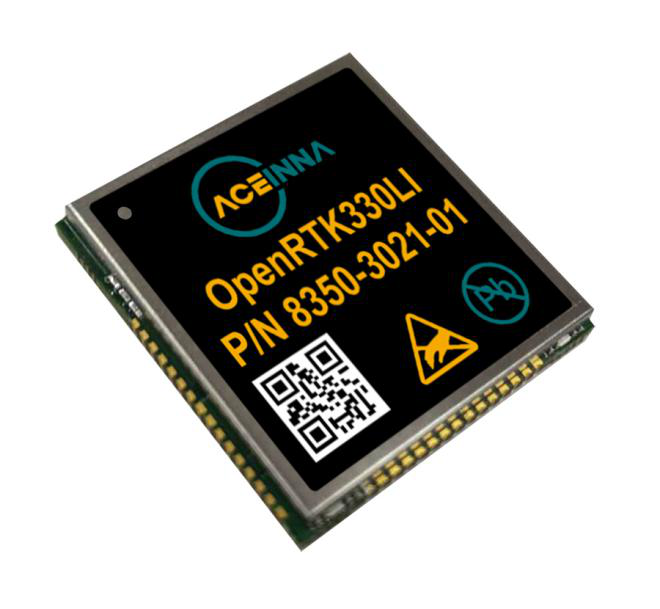
Module designed for developers creating guidance and navigation systems for autonomous vehicles, robots, drones, industrial, construction and agricultural machinery
Aceinna launched its OpenRTK330L at CES 2020, the massive annual consumer electronics show taking place Jan. 7-10 in Las Vegas. The company is located at Booth 6738, CES North Hall, Automotive Pavilion.
OpenRTK330L is a low-cost,high-performance triple-band RTK/GNSS receiver with built-in triple redundant inertial sensors. Designed to replace the expensive and bulky precision RTK/INS systems used in today’s autonomous systems, the compact navigation solution meets the challenging performance, reliability and cost requirements of the automotive market along with the needs of robot, drone, construction and agriculture systems, Aceinna said.
Demonstration Drive
Aceinna is demonstrating its GNSS/INS-based autonomous vehicle localization technologies on its test vehicle, which drove from Silicon Valley to Las Vegas.
The company is recording live drive-test data that demonstrates how its precision positioning solutions provide high accuracy and reliability. Precision location capability is critical for all levels of autonomous driving.
OpenRTK330L includes a triple-band RTK/GNSS receiver coupled with redundant inertial sensor arrays to provide cm-level accuracy, enhanced reliability, and superior performance during GNSS outages.
The OpenRTK330L integrates a precise 2 Degree/Hour IMU to offer ten to 30 seconds of high accuracy localization during full GNSS denial. This enables autonomous system developers to safely deliver highly accurate localization and position capabilities in their vehicles at prices that meet their budgets.
Image: Aceinna
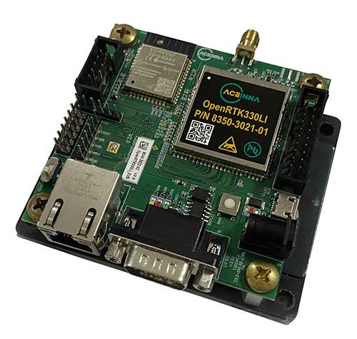
OpenRTK330L’s embedded Ethernet interface allows easy and direct connection to GNSS correction networks around the world. OpenRTK330L’s CAN bus interface allows simple integration into existing vehicle architectures.
The multi-band GNSS receiver can monitor all global constellations (GPS, GLONASS, BeiDou, Galileo, QZSS, NAVIC, SBAS) and simultaneously track up to 80 channels. The module has RF and baseband support for the L1, L2 and L5 GPS bands and their international constellation signal equivalents.
The inertial measurement unit and dead reckoning function contains a total of 9 accelerometer and 9 rate gyro channels based on Aceinna’s unique triple redundant six-axis IMU array. By integrating a triple-redundant IMU array, the OpenRTK330L is able to recognize and utilize only valid sensor data, ensuring high-accuracy protection limits and certifiability under ISO26262 standards.
Open Navigation Platform
“The combination of a triple-band GNSS receiver and a high-precision IMU has enabled us to make a remarkably accurate, small, reliable and cost-effective GNSS/INS solution,” said Mike Horton, CTO of Aceinna. “The OpenRTK Precise Positioning Engine optimizes satellite tracking and high RTK fixes rates while integrating seamlessly with Aceinna’s open-source, developer-friendly Open Navigation Platform.”
The Open Navigation Platform allows custom embedded application development on top of Aceinna’s positioning engine and dead-reckoning algorithms. Autonomous solution developers have full access to all resources on the OpenRTK330L module including the GNSS receiver measurement data, IMU measurement data and all interfaces.
The OpenRTK330L GNSS receiver supports GPS (L1 C/A, L2C and L5), GLONASS (L1OF, L2OF), BeiDou (B1I, B2I), GALILEO (E1, E5a, E5b, E6) QZSS (L1 C/A), and NAVIC. The IMU sensor array includes a triple-redundant, 3-axis MEMS angular rate sensor, and a triple-redundant, 3-axis MEMS accelerometer.
Hardware also includes, Ethernet, UART, SPI and CAN interfaces for versatile integration into a host system. Additional specifications include operating temperature range of -40C to +85C, and qualification to standard automotive shock and vibration levels.
UAVs are finding places in the lives of more people than ever — farmers employing crop-spraying drones to counter a locust infestation in Pakistan, finding the way towards useful inspection tasks at an operating airport in the U.K., large airborne vehicles providing joy-rides around the U.S., and unfortunately showing up where they are not wanted so security staff have to use protection systems to deal with them.
Crop Spraying
New unmanned air vehicle (UAV) applications keep appearing. Once they do, they start to spread locally and even around the world. Crop management using UAVs has significantly progressed.
The U.S. has used crop spraying to improve crop yield for many years, defending against insect infestation and plant diseases. GNSS guidance systems for crop-spraying aircraft was an early satnav equipment application that eventually became a standard for any fliers contacted by farmers to apply pesticides to protect their crops. Then companies began offering turn-key spraying, which was highly efficient and effective.
UAVs are now entering this segment — they are capable of carrying higher capacity tanks, and autonomous/semi-autonomous navigation enables spraying with minimum supervision. This option is becoming more readily available to the farmer and costs less than using manned aircraft.
Both Japan and China have used UAVs extensively for crop spraying; other countries turning to the solution are Africa, the U.S. and India. In China, more than a hundred different types of UAV are in use in agricultural applications.
Farms around the mega-city of Karachi, Pakistan, have been infested by locusts, but the local government is short of the helicopters and ground applicators normally used for spraying pesticides. A recent graduate returning from his doctoral course in China brought with him knowledge of unmanned vehicle use in agriculture, and is urging rapid local adoption of UAV technologies to combat the locust infestation.
Pakistani agriculture expert Shahzad Nahiyoon claims that UAVs are better suited to crop protection for small farms within difficult contours of the surrounding region. They are less expensive to operate than manned fixed-wing and rotary aircraft, may be operated locally from outside spray contamination zones, and can spray in confined areas. Equipped with a 20-liter tank, spraying one or two 20-meter-wide swaths, 6 to 10 hectares per hour can be treated.
Drones at the airport
Growing a little weary of drone incidents around airports, I was pleased to see a report I had overlooked from a year ago which indicated that trials at Manchester airport in UK had demonstrated airport and drone compatibility. This basically happened because an Air Traffic Control (ATC) system for unmanned aircraft or Unmanned Traffic Management (UTM) was shown to keep drones flying around the airport under full control while integrated with regular airport and drone operations.
The trial — referred to as Operation Zenith — sponsored by the National Air Traffic Systems (NATS), made us of the GuardianUTM airspace management system, supplied by Altitude Angel, as the control system for eight trial drone missions at the airport. The drone UTM system was connected to the real-time Air Traffic Management (ATM) system which manages ground and air traffic at the airport, to ensure the control and safe separation of drones and aircraft. The UTM system also provided controllers with a real-time view of all operating drones.
The trial demonstrated the efficient regulation of drone traffic within and around the extremely sensitive airport region. Everyone engaged in the trial made use of real-time electronic map displays driven by the UTM system, showing everything flying in and around the airport; aircraft and drones. Drone pilots used this information to ensure their operations remained safe while operating so close to commercial aircraft in the air and on the ground.
NATS has now formed a strategic partnership with Altitude Angel to deliver this integrated UTM system at airports in the United Kingdom. The UTM system has successfully completed initial pilot trial and evaluation and now NATS intends to further demonstrate UAV management control at six U.K. airports later this year.
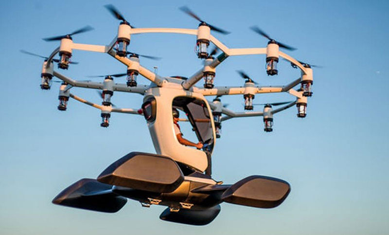
Thousands sign for ride with Lift Aircraft
Hexa in flight (Photo: Lift)
Lift Aircraft unveiled its 18-rotor Hexa unmanned/manned aircraft more than a year ago — what’s new now is that 13,000 people have signed up to take one for a ride.
The large drone weighs in at 432 pounds and can fly for 10-15 minutes with a single passenger.
The Hexa is controlled by a single joystick, and an onboard iPad provides route guidance and manages take-off and landing. Classed as a powered ultralight air vehicle, it can be flown without a pilot’s license, so Lift announced that it will offer Hexa flights to anyone wanting to fly (in 25 selected U.S. cities) provided they physically fit into it and weigh less than 250 pounds.
Lift intends to map each recreational flight area in 3D, and plug this map into the vehicle control system. The 13,000 people who signed up can expect to pay $125-250 for each joy ride. Lift has yet to announce the first location where the fun rides will take place.
Counter-UAS system downs drones in Philippines
The Southeast Asian Games were recently held in the Philippines with thousands of participants from eleven countries of Southeast Asia — the event was spread across 23 cities around the country. However, a number of uninvited drones showed up during the opening ceremonies on November 30th to take a look, but fortunately all were quickly dispatched.
The DroneShield counter-UAS system had been deployed in advance for protection of the event, and the local security forces used the system to detect and disable the invaders. According to the company, security personnel found the drones using body worn RF detection devices, and the Dronegun was then used to disable them.
Jamming the control link and GNSS L1 and L2 frequencies, UAVs are generally stopped in mid-flight when illuminated by the rifle-like device. DroneNode jammer in a suitcase was also used to provide blanket protection over a 1km circular area when the alarm was raised.
In all, seven unauthorized drones were disabled, some of which were apparently flying near the intended flight path of the helicopter bringing President Rodrigo Duterte to the opening ceremony.
Summary
It might seem a little ridiculous that we’ve had to come up with systems to counter uninvited or malicious drones (C-UAS). Making provisions for protection is probably something most sensitive facilities will have to do. Its possible that governments may already be investing in such technology to protect many facilities. More drones available for useful, productive and even recreational applications means some can end up in the wrong hands.
Nevertheless, good stuff comes out of drone applications, and the benefits seem to by far outweigh the need to protect ourselves against bad actors.
Hitec stated in a press release, “SUI’s experience in engineering and manufacturing small unmanned aircraft systems contributes perfectly with our expanding unmanned product platforms and progressive mapping and data acquisition solutions.”
Hitec Commercial Solutions continues to obtain integral assets which strengthen those products utilized for efficient surveying in agriculture, energy and gas, public safety, construction and first response services.
The acquisition agreement was closed Aug. 9 after approval by core members of the board of directors.
Hitec offers a variety of unmanned platforms, including the XENO FX, its proprietary fixed wing platform. The company also partners with Quantum Systems.
Founded in 2015, SUI provides technology in professional-use small unmanned aircraft systems (sUAS) with its Endurance and Endurance LT customized multirotor packages and ground controller system.
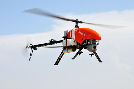
Emergency response providers participating in a Design Thinking workshop organized by the ResponDrone Project have indicated that they would like to use drones to gather and distribute crucial information and provide communication networks in disaster areas.
Preliminary results from the workshop, held in Thessaloniki, Greece, in November, indicate that first responders view the constant provision of real-time information in crisis situations as one of the most valuable benefits arising from using drones in disaster management missions.
The results of the Design Thinking workshop will be presented and discussed with the ResponDrone consortium at the project’s General Assembly, which will take place on Dec. 10–12 in Paris.
ResponDrone is an international project co-funded by the EU and the Korean government, which aims to develop an integrated solution for first responders to easily operate a fleet of drones for multiple synchronized missions to enhance their situation assessment capacity and their own protection.
The workshop, attended by representatives from first-responder organizations and industry partners of the ResponDrone consortium, took place to assess the best possible system requirements.
The aim of the ResponDrone project is to develop and evaluate a situation awareness system for first responders in emergency situations. The system will provide crucial information and communication services to all relevant stakeholders in a disaster situation.
First responders said they would like the ResponDrone system to:
provide reliable and validated real-time information
be flexible and open to information from already existing data sources
be able to visualize different information layers in a customizable manner
be fast and easy to deploy
be able to provide near future predictions regarding the development of the disaster situation.
Workshop participants included regional and national authorities in charge of first response, state agencies responsible for carrying out on the ground first response actions, rescue services and fire departments from Greece, France, Armenia, The Netherlands, Latvia, Bulgaria and Israel.
According to the first responders, a disaster can initially be described as a black box, which needs to be opened. Gathering relevant and reliable information from the disaster area and combining it with already available data, as well as rapid distribution of information to all relevant stakeholders, are the top priorities in disaster management.
The deployment of drones as a means of enabling the afore-mentioned capabilities seems to be a promising approach. It is crucial that the data gathered by drones is presented to the right people as soon as possible, preferably in real time.
“The workshop clearly showed the urgent need for the constant provision of real time information,” said ResponDrone project coordinator Max Friedrich from the German Aerospace Center (DLR).
“First responders wish to receive real-time data on current occurrences in the disaster area, on the position and status of potential victims and the first response units deployed in field, as well as the status and current location of available resources.”
Friedrich added that the ResponDrone system would be designed to provide highly accurate real-time information. The flexible system would gather information from various data sources and should be designed for fast and easy deployment.
ResponDrone has already begun developing an integrated solution for first responders to easily operate a fleet of drones with multiple synchronized missions to enhance their situation assessment capacity and their own protection. This system of systems will simplify and accelerate situation assessment and sharing, decision making and operations management, while requiring only a small crew to operate it.
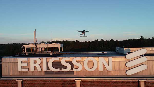
Test and measurement specialist Rohde & Schwarz has supplied mobile network testing tools used in drone-based network coverage, performance and operation tests managed by Ericsson, a global leader in network infrastructure.
Testing mobile coverage. A project team based in Jorvas, Finland, and led by Ericsson’s 5G Readiness Program RAN Technical Lead Richard Wirén, has developed— together with Centria University of Applied Sciences — a novel system for testing cellular mobile network coverage.
The new system uses mobile network-testing scanners and smartphones from Rohde & Schwarz mounted on a drone that can be programmed to execute automatic tests with considerable flexibility, for example for precise route selection and drone speed control.
This solution is especially valuable for industrial use cases. It also has the advantages over traditional walk and drive tests by providing unprecedented repeatability and positional accuracy with the ability to verify beamforming and map coverage in 3D.
Drone-mounted scanner. The R&S TSMA6 network scanner is mounted on a drone and is able to simultaneously verify important LTE and 5G NR coverage metrics such as reference signal received power (RSRP) and signal-to-interference-plus-noise ratio (SINR) in accordance with 3GPP standards.
When combined with the R&S QualiPoc Android smartphone-based optimizer, IP trace, application quality of service (QoS) metrics such as serving cell parameters are possible. The solution currently uses LTE user equipment (UE) but will soon be further developed to include 5G UEs such as the Samsung S10 5G.
The drone can be programmed to follow an exact three-dimensional route.
Repeatable tests. More than 20 successful measurement flights conducted so far have shown the solution procedure and results to be extremely repeatable. The drone flights were of various duration, altitudes and routes, depending on the test case.
Control, authentication and air traffic control are considerable challenges to the development of robust drone-based solutions. In this new system they are conducted over cellular networks, eliminating the requirement for line-of-sight connection between the drone and its pilot.
The unique procedure enables unprecedented 3D accessibility, positional accuracy and repeatability of the testing.
It also opens up new possibilities to ensure end-user QoS for demanding 5G use cases such as industry 4.0, automotive and public safety, Rohde & Scwarz said.
5G New Radio. The deployment of 5G New Radio (NR) brings new applications of cellular networks for subscribers, government and industry. It also makes the verification of the correct coverage, performance and operation of networks more critical, increasing the demand for accuracy and accessibility in traditional field network tests.
“For 5G to realize its promise, field verification of operation and quality is essential, and this development is a pioneering way to ensure our customers receive the network performance they require,” said Richard Wirén, 5G Readiness Program RAN Technical Lead from Ericsson. “We are delighted to utilize test solutions from Rohde & Schwarz that have proven themselves very reliable and are excited that we now have access to solutions based on commercially available 5G NR UEs such as the Samsung S10 5G.”
“We are delighted to combine our industry-leading mobile network testing know-how with Ericsson’s long tradition of network innovations to ensure the delivery of end-user Quality of Experience as 5G NR becomes a reality,” said Hanspeter Bobst, vice president of mobile network testing for Rohde & Schwarz.
Ericsson and Rohde & Schwarz are collaborating with Tampere University and Centria University of Applied Sciences, and the project forms part of the Business Finland 5G FORCE program.
Future developments will focus on testing critical 5G applications such as public safety and machine-type communications for Industry 4.0, extending the frequency to extremely high frequencies of the mmWave bands and testing in an urban environment.
GE Aviation and Hybrid Project team to provide commercial high-endurance vertical takeoff and landing (VTOL) UAV, with Auterion and GE Aviation providing comprehensive integration of ground, cloud and airborne components
GE Aviation has teamed with Hybrid Project to provide a VTOL UAV designed for high-endurance commercial applications at scale. Flight testing is underway, with commercial availability targeted for the first quarter of 2020.
The agreement enables Hybrid Project’s 35-pound hybrid-powered SuperVolo VTOL UAV with a full stack airborne computing hardware platform, flight and safety management, and integration from GE Aviation and Auterion.
GE Aviation’s computing platform enables flight control and airborne computing power at the edge while maintaining an independent and authoritative safety controller. Auterion’s Enterprise PX4 operating system resides on the vehicle, in the cloud, and the ground station.
The integration is the result of an agreement announced earlier this year between GE Aviation and Auterion to provide all-in-one hardware and software platform for commercial drones.
“The combination of Hybrid Project’s SuperVolo airframe, GE Aviation’s computing platform, and Auterion’s software stack enables an all-in-one solution that readily scales for commercial applications,” said Matt Vacanti, product leader, Avionics Systems for GE Aviation. “A highly integrated system is critical to achieving scalable commercial UAV operations.”
Hybrid Project’s SuperVolo has been designed from the ground up with an emphasis on endurance flight, ease of maintenance, and modularity. The combined system is comprised of technologies and services which have the capability to enable commercial operations in complex environments while meeting regulatory and mission outcomes.
“This collaboration, and the combined solution, will increase commercial operator flexibility, efficiency, and overall performance to a level not previously available in its class,” said Ryan Pope, co-founder of Hybrid Project.
Auterion’s Enterprise PX4 software is built on top of open software standards that are supported by a global developer community. Auterion’s enterprise software also provides the infrastructure enabling online workflows, compliance monitoring, and enterprise fleet management. “With Auterion software, the Hybrid Project SuperVolo flies farther, safer, and more efficiently, unlocking new BVLOS capabilities and missions that were previously not possible before commercial drones of this class were available,” said Kevin Sartori, co-founder of Auterion.
Skyward has updated its InFlight mobile ground control system app. It now offers operation planning and mobile LAANC requests.
In October, Skyward released a major update to its airspace intelligence map on both web and mobile platforms. The update included a new airspace design, clear LAANC grids, and a redesigned user experience.
It also integrated essential ground intelligence, including information on transmission lines, pedestrian walking paths, and 1 million vertical obstacles, as well as 3D views of key structures.
The new features announced this month include the ability to create and plan flights from mobile device. Users can now plan flight areas, check airspace and deploy without leaving InFlight, directly from the airspace intelligence map.
Users can now also make LAANC requests in the field to give users faster, greater access to controlled airspace. With LAANC, users can request access to airspace around airports and receive authorizations in near real time.
Autonomous vehicle startup announces availability of driving sensing solutions for purchase to OEMs
DeepRoute has released for sale its autonomous vehicle sensing solution, DeepRoute-Sense. DeepRoute is a CES 2020 Innovation Award Honoree.
Photo: DeepRoute
DeepRoute-Sense is an L4-level self-driving full-stalk solution that aims to enable the autonomous vehicle industry to achieve quicker sensor deployment. It includes a sleek, lightweight set-top box and sensor-fusion calibration service.
The roof box consists of GNSS, eight vehicle cameras, three lidars and a series of other sensors to help correspondence and data synchronization between the controllers.
DeepRoute has independently designed the mechanical structure of the roof box, which has outstanding diversion, heat dissipation and sealing functions. The set-top box is lightweight, small and with high impact resistance. With four tripods, the roof box can be easily mounted to the roof of different vehicle models for sensor deployment.
“The team at DeepRoute has worked hard on the development of DeepRoute-Sense and we are excited to finally share our technology with the industry,” said Shuang Gao, COO of DeepRoute. “By bringing this to the market, we are hoping to fuel progress within the industry and bring full vehicle autonomy to be one step closer to the masses.”
The solution uses a DeepRoute-developed in-vehicle camera that features anti-glare, anti-ghosting and highly reliable signal detection. Compared with industrial cameras, the camera comes at a lower cost, but also offers a higher dynamic range.
The roof box has been developed to accommodate different and extreme weather conditions, whether it be during intense sunlight or nighttime high-beam illumination, and can stably handle the exposure and avoid overexposure.
The set-top box includes a sensor data-processing device, the ADS Synchronous Controller. It is pre-processed and fused with the massive data from GNSS, cameras, lidars and other sensors through high-precision time and space synchronization. The ADS Synchronous Controller also supports DNN and SLAM hardware acceleration, which greatly increases computational efficiency.
A lot has happened in the world of unmanned aircraft over the last several weeks, and this month we’ve captured a cross-section of news that illustrates the variety of applications and goings-on across the industry. These include:
drone delivery to a nuclear submarine,
Uber Eats launching a new delivery drone,
a new heavy-lift UAV,
Chinese DJI drone use banned by the U.S. interior department,
the Grand Sky facility in North Dakota demonstrating control of a NASA Global Hawk over California,
runway inspection using drones at an airport in Canada, and
a drone-of-sorts completing 780 days in orbit.
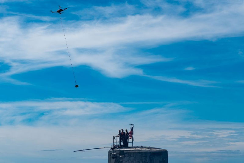
Package delivery to USS Hawaii (Photo: U.S. Navy/Mass Communication Specialist 1st Class Michael B. Zingaro)
Submarine delivery. The University of Hawaii and the U.S. Navy recently tested out a new way to supply an operational nuclear sub with a few essential items while the Virginia-class fast-attack submarine USS Hawaii was off the West coast of Oahu. A five-pound package of circuit cards, medical supplies and food too – which someone surely must have snuck in — was delivered using a Skyfront Perimeter gas-powered hybrid drone. The UAV has five-hour endurance, easily flying just one mile out to sea and back to complete the test delivery on Oct 10.
The package was lowered on a cable from the Perimeter drone and captured by a ‘snag’ pole extended off the sail of the submarine. This timely small package delivery to an underway sub has apparently led to the creation of the submarine force’s first UAV squadron in the Pacific, according to the Navy.
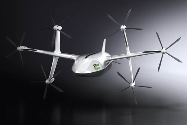
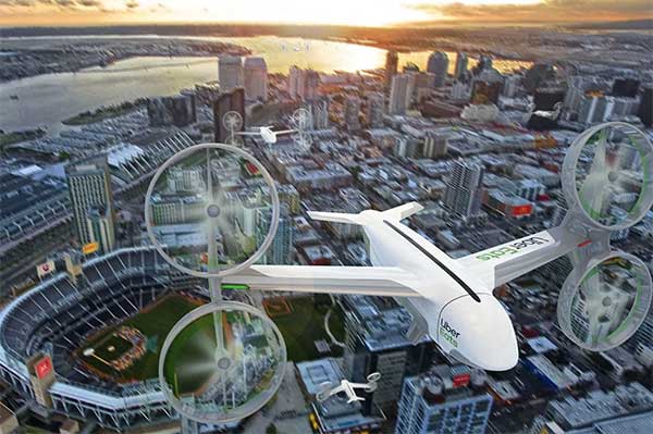
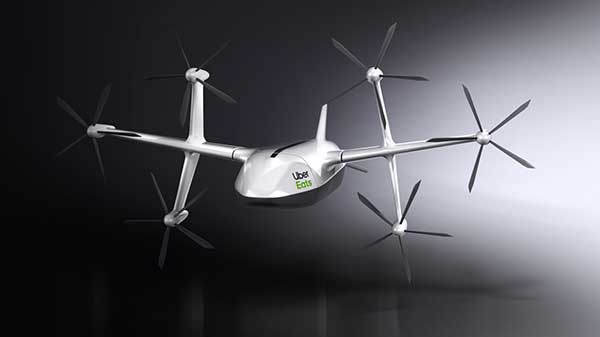
Uber Eats. Uber Eats has been testing food deliveries from McDonald’s near San Diego State University, and has just announced a new 6-rotor vertical take-off delivery drone it plans to use for more test deliveries next year in San Diego.
Uber Elevate delivery drone (Photo: Uber)
The ideal delivery profile for this drone is a meal for two picked up from a restaurant six miles away from dispatch in eight minutes, another six miles to make the delivery and then six miles to return to base — maybe less than 20-30 minutes all told. However, they have an intermediate drop-off to a ground-based delivery driver who then travels to the customer’s door to actually deliver the food. This process contrasts with Amazon’s approach — they are planning to lower packages on a cable directly to the customer – but food delivery might actually need a guy in a truck knocking on your door with hot food.
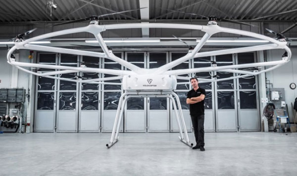
Heavy-lift drone. The Heavy-Lift VoloDrone, manufactured by Volocopter in Germany, flew for the first time in October. Targeted at the logistics sector, its anticipated that the large UAV may also find applications in agriculture, and other operations where a large – up to 440 pounds – payload is required. Velocopter has so far focused on unmanned air-taxi transports, but the larger scale involved in people transport appears to have spun off into a heavy-lift derivative UAV.
Christoph Hommet, chief engineer, with the heavy-lift VoloDrone. (Photo: Volocopter)
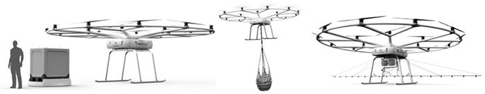
The VoloDrone is a powerful, fully electric, heavy-lift utility drone which is anticipated to have a range of up to 25 miles carrying a 440-pound payload. The rotor area has a diameter of 30 feet and the vehicle is 7.5 feet high. It can be remotely piloted or can fly autonomously on pre-set routes.
Loads can be carried between the legs of the landing gear on standard rack mounts or slung below, or a tank and sprayer could be fitted for agricultural applications. The 18 rotor multicopter platform uses swappable lithium-ion batteries and an in-house flight control system, and benefits from existing development and test of the air-taxi Velocopter.
Anywhere ground transportation or construction operations are challenged by difficult access, the VoloDrone might assist by providing an airborne option. It is designed as a universal air-lift vehicle which may be adapted to different use cases by the addition of special-purpose accessories.
Examples of VoloDrone load configurations. (Photo: Volocopter)
DJI drones barred. The U.S .Interior Dept. (DoI) has barred the use of DJI dones, except for emergency purposes. With a combined department fleet of over 800 drones, around 15% are supplied by Chinese manufacturer DJI.
Amid the on-going trade war between China and the U.S., members of Congress have grown increasingly concerned about American use of Chinese technology – whether DJI drones, or Huawei networking equipment. Recently Congress has proposed the American Drone Security Act to limit Government agencies’ use of Chinese equipment.
In anticipation of this issue DoI has already been working with DJI for over 15 months to identify possible security gaps in drone design, and DJI has come up with a “Government Edition” software load which ensures data is only gathered and stored on-board the drone and is isolated and downloaded for only DoI use after each flight — data transmission has been eliminated as a possible source of data leakage. DJI even volunteered to partial manufacture in the US. Therefore, DoI had previously resisted Congressional pressure to discontinue use of its fleet of DJI drones.
Nevertheless, DoI Secretary Bernhardt has ordered that Chinese drone use be now discontinued until an internal review is completed. In the meantime, DJI drones may only be operated by DoI for emergency purposes, “such as fighting wildfires, search and rescue, and dealing with natural disasters that may threaten life or property.”
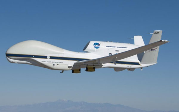
NASA Global Hawk UAV (Photo: NASA/Tom Miller)
Large BVLOS drones. The Grand Sky Beyond Visual Line of Sight (BVLOS) facility in North Dakota has become an operational base for large UAVs, including the General Atomics’ Predator and Northrup Grumman’s (NG) Global Hawk. The Grand Sky facility is immediately adjacent to Grand Forks Air Force Base, where the RQ-4 Global Hawk high altitude, long endurance autonomous aircraft is based.
In order to offer full operational capability to its intended customer base at Grand Sky, Northrup Grumman is building a hangar and has also established a Transportable Operations Center (TOC) in its Grand Sky Mission Control Center. It was through this TOC on October 10th that NG was able to take control of an in flight Global Hawk mission in California.
A NASA crew in California had managed the take off and flight of their Global Hawk from the NASA Armstrong Flight Research Center (AFRC) on Oct. 10, 2019. During the mission, the flight team at Grand Sky took over control of the aircraft and executed a series of flight maneuvers to demonstrate the operational capability of the TOC. This capability is key for the Grand Sky facility to become fully operational.
A Microdrone md4-1000 used in the surveys at EIA. (credit: EIA)
Runway inspection. Drones are never allowed to operate anywhere near an active airport, so it’s something of a switch to learn that the Edmonton International Airport (EIA) in Alberta, Canada , OK with operating a drone within the confines of the airport. Fortunately it’s a case of improving the safe operation and maintenance of the extensive runway infrastructure at the airport.
EIA has two million square feet of runways, taxiways and aircraft handling aprons which are all subject to wear by aircraft and suffer from the harsh weather extremes which are common in Canada. Therefore regular maintenance inspections are mandatory. Undertaking inspections manually in the past could take days to perform, so EIA adopted the use of drones to complete inspections much quicker and with higher accuracy.
The Microdrone md4-1000 drone is flown by Canadian company AERIUM to collect Lidar (Light Detection and Ranging) data and photographic/video imagery of EIA’s runways. The data collected is used to more accurately predict when to conduct preventative maintenance on ground infrastructure used by aircraft. Drone operations were approved by Edmonton Airport in collaboration with Nav Canada and AERIUM. EIA has previously flown a drone to minimize the number of birds on the airport during aircraft movements and in the process conducted the first-ever drone night flight at the airport.
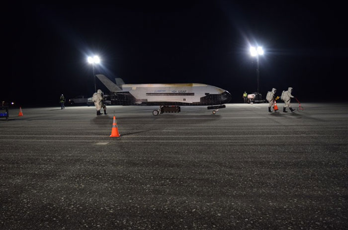
A X-37B lands at the Kennedy Space Center. (Photo: USAF)
X-37B orbital vehicle. Finally, the daddy-of-all applications for remotely piloted vehicles became more apparent on Oct. 27, at 3:51 in the morning when the U.S. Air Force’s X-37B Orbital Test Vehicle successfully landed at NASA’s Kennedy Space Center Shuttle Landing Facility after 780 days on orbit.
The fifth mission was launched on Sept. 7, 2017 from Cape Canaveral Air Force Station, Florida by a SpaceX Falcon 9 booster. Looking like a miniature version of one of the retired Space Shuttle fleet, the X-37B is managed by the Air Force Rapid Capabilities Office, and ‘performs risk reduction, experimentation and concept of operations development for reusable space vehicle technologies.’ Long endurance stuff – the previous flight lasted 718 days. “This mission successfully hosted Air Force Research Laboratory experiments, among others, as well as providing a ride for small satellites,” said an Air Force spokesman.
The X37B provides a unique capability to test new systems in space and return them to Earth and enables the U.S. to more efficiently, effectively and rapidly develop evolving space capabilities. The U.S. Air Force is preparing to launch the sixth X-37B mission in 2020.
Final thoughts. As drones chug steadily along the path towards a rapid airborne delivery system, urgent deliveries to both submarines and hungry people ordering food are making progress. Heavy-Lift capability is evolving out of air-taxi research. The effects of trade wars and security concerns are touching established drone operations. We can now control huge aircraft remotely from almost anywhere. Runway inspection is being automated just like any other drone inspection/surveillance mission, and remote space operations are now regular practice.
It’s an expanding world of applications for drones, with many more different and perhaps unanticipated ones yet to come.
Uber Elevate, Uber’s aviation division, unveiled a new food-delivery drone at Forbes’ Under 30 Summit in Detroit, according to various news reports.
The six-rotor UAV is vertical- and horizontal flight-capable, Uber Elevate head Eric Allison said at the conference. It has a range of 18 miles and an 18-minute flight time, and can carry enough food for two adults.
The drones will land in designated safe-landing zones, where human couriers will pick up the food and bring it to customers’ doors. The company might also land the drones on parked Uber cars (tagged with QR codes), which will carry the meals to their final destinations.
Uber’s Elevate Cloud Systems will track and guide the drone, as well as notify a delivery driver when and where to pick up the food.
The program is expected to roll out next summer in San Diego, where Uber Elevate has been testing urban aerial delivery via the UAS Integration Pilot Program (IPP).
Uber’s vision of a city sky filled with Eats delivery drones. (Image: Uber)
New solution integrates the real-time Kongsberg IRIS UAS airspace management picture into the AiRXOS’ Air Mobility Platform to provide integrated unmanned traffic management services around critical infrastructure
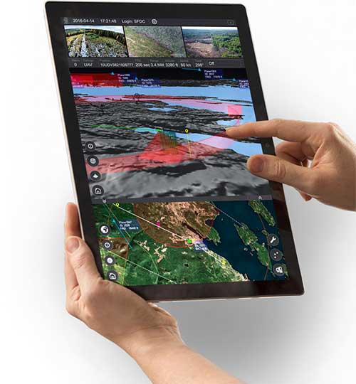
AiRXOS, part of GE Aviation, has fully integrated the real-time airspace picture from the Kongsberg Geospatial IRIS airspace management application into its own Air Mobility Platform for unmanned traffic management.
IRIS UAS is a spatial awareness system that allows UAS pilots to operate safely beyond visual line of sight (BVLOS). The system is shown here running on a Windows Surface Pro tablet. (Photo: Kongsberg Geospatial)
IRIS UAS fuses multiple disparate, real-time sensor feeds to create a highly accurate airspace picture around critical infrastructure locations such as airports.
This provides real-time calculation of aircraft separation, airspace monitoring alerts and communications line-of-sight prediction to enable detect and avoid for safe beyond visual line of sight (BVLOS) operations.
The real-time local airspace picture is then integrated into the cloud-based AiRXOS’ Air Mobility Platform, a dynamic, cloud-based foundation, purpose-built for advanced operations and the evolving future of transportation.
The Air Mobility Platform manages the volume, density, and variety of unmanned traffic management (UTM) data, and provides enterprises with a single platform to connect and manage operations, applications and devices.
Through this collaboration, the companies will provide UTM customers with a fully integrated view of airspace for real-time airspace insights, and greater scalability and repeatability of advanced operations.
“Situational awareness of the airspace across applications, unmanned aerial system (UAS) advanced operations, conformance monitoring, compliance, and pilots is critical to a UTM environment — allowing enterprises to be more responsive and efficient,” said Ken Stewart, CEO, AiRXOS. “Our partnership combines Kongsberg Geospatial’s expertise in airspace management with AiRXOS’ dynamic platform, applications, and services, providing customers with the opportunity to truly scale critical infrastructure advanced UAS operations like BVLOS and multi-vehicle, helping to lower risk and increase savings.”
“We’re very pleased to be working with an unmanned traffic management innovator like AiRXOS,” said Ranald McGillis, president of Kongsberg Geospatial. “Their ability to create a comprehensive surveillance view of operations and then to scale it for a nationwide use provides an excellent and very unique use case for our technology.”
Lidar USA is partnering with Innoflight Technology, a manufacturer specializing in UAV systems for surveying, mapping and inspection.
As a result of the partnership, Lidar USA is offering the Galaxy 950 platform to carry any of its sensors while consistently providing flight times over 30 minutes.
Based in Somerville, Alabama, Lidar USA specializes in the design and integration of economical lidar sensors.
Innoflight and Lidar USA’s partnership is another step for both companies to offer turn-key solutions focused on quickly and safely acquiring high-quality data.
Innoflight designed the Galaxy 950 to simplify the flying aspect of remote sensing with UAVs. The helicopter includes a parachute, automatic takeoff and landing, and extended visual-line-of-sight capabilities to maximize productive time.
For corridor/electric utility line projects, the Galaxy 950 pairs well with the recently announced CL-90 by Teledyne Optech. As the first integration partner of the new compact lidar system, Lidar USA is offering maximum productivity at UAV flight ceilings while achieving improved canopy penetration and exceptional downward point density.
“Lidar USA and Innoflight Technology are both committed to customer success, and this partnership provides the whole package for lidar mapping solutions with UAV,” said Jeff Fagerman, CEO of Lidar USA. “Innoflight’s Galaxy 950 offers exceptional performance in safety, flight duration, and ease of use, which is what our customers need for their projects.”
The Galaxy 950 is now available from Lidar USA as an integrated package with any of their scanning systems.