Hexagon has finalized its acquisition of Septentrio NV. By integrating Septentrio’s GNSS platforms with Hexagon’s existing portfolio, the company aims to enhance access to high-accuracy and high-performance positioning technology designed for Size, Weight and Power (SWaP) efficiency.
According to Gordon Dale, President of Hexagon’s Autonomous Solutions division, the collaboration will enable the delivery of advanced solutions for autonomy and mission-critical applications across various industries.
The combined expertise of both companies is expected to accelerate the adoption of autonomous systems while addressing the needs of emerging sectors such as robotics, UAVs and other mission-critical technologies. Septentrio, headquartered in Leuven, Belgium, will maintain its existing business model of providing GNSS technology to a broad base of original equipment manufacturers.
A brand-new innovation in the world of unmanned aircraft is becoming more rare as the industry matures. However, a Denver, Colorado company has been innovating continuously since 2017, patenting a new approach to vertical take-off and landing (VTOL) for a different, ground-breaking design.
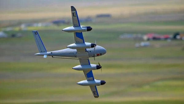
The PteroDynamics’ Transwing UAV is not only autonomous but also uses a folded wing design that enables vertical take-off and virtually seamless transition to horizontal flight — sometimes compared to the simplicity of how a bird unfolds its wings to become airborne.
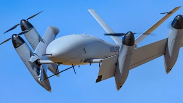
Transwing UAV climbs out on another logistics mission. (Photo: Ptero) Transwing in forward flight. (Photo: Ptero)
According to the company, Its unique “transverse, folded wing design” allows an extremely fast change from vertical to horizontal flight without almost any loss of momentum. Then horizontal flight can be rapid, with four powerful electric motor-driven props providing an initial dash speed of up to 100 knots, an economic cruise of 65 knots with the two outer props neatly folded out of the slipstream, and a range of 60 nm. However, endurance is not so hot currently.
Throughout the years, Ptero has carefully protected Transwing technologies by filing many patents — four of which have been granted and 15 are pending — in 11 jurisdictions around the world.
The target applications have been shore-to-ship, ship-to-ship, and ship-to-shore automated cargo transport of essential small packages (up to 15 lb) for fleet sustainment. The U.S. Navy has now contracted to evolve the existing P4 UAV variant to a P5 design carrying 50 lb payloads. This recent development contract is anticipated to result in a fully loaded 350 lb vehicle with around 400 nm range and an enhanced endurance of up to 10 hours, using a hybrid gas/electric power plant.
The U.S. Navy has observed the operation of earlier Transwing versions during several exercises, including an October 2023 demonstration off the deck of USNS Burlington in Key West, Florida. Then again, in June 2024, off the deck of the USS Curtis Wilbur guided-missile destroyer while the ship was at sea around Hawaii. In this latest demonstration, three Transwing vehicles flew 12 autonomous flights, each carrying around 15 lb cargo, with more than 20 knots winds during takeoff and landing. Although labeled as “flying autonomously,” two Transwing aircraft were controlled by one operator. Ptero says that flights from take-off to landing were fully autonomous – so load the route and operational parameters and go – this appears to be how they were flown.
Photo: Ptero
The unique transition mechanism appears to involve cables or rods pulling each wing around a pivot, which seems to have a cog simultaneously traveling along a ramp inside the fuselage end of each wing—effectively moving both wings from a stowed to horizontal position. However, this is just a supposition, as Ptero did not provide details.
Ptero also has big plans for a P7 huge cargo Transwing — 3,600 lb loaded weight, 620 lb payload, 1,000 nm range, and 9 hours endurance.
A fascinating new UAV initiative, which has the potential to not only fulfill the U.S. Navy’s need for essential small package delivery at sea but also fill this need for other friendly navies around the world. Afterward, hopefully, the many thousands (118,928 Merchant Ships) of commercial ships plying the oceans worldwide might want essential package transport. And once the barrier to the commercial market is broken, perhaps many other long-distance transport applications could emerge.
Meanwhile, Amazon is having a few difficulties with drone deliveries in College Station, Texas. Residents have been complaining about noise from drones performing over 600 round trips daily, so Amazon has recently discontinued its drone deliveries.
Amazon MK30 drone is quieter (Photo: Amazon)
With an improved propeller design, Amazon claims its new MK30 drone is around half as noisy as before, and the company intends to resume operations when new software changes aimed at improvements to enhance safety are available. The MK30 also has twice the range and is equipped with sense and avoid capability.
The company shared that two drones collided during testing at the Amazon private testing location. Analyzing and correcting this issue has taken a while, but quieter, safer deliveries are expected to resume shortly in Phoenix, Arizona and Texas.
A new VTOL vertical to horizontal UAV transition capability leading to ship-to-shore essential package deliveries is apparently in the early stages, and another few teething troubles for Amazon package deliveries — signs that there is still lots of life in this industry.
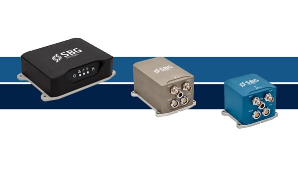
SBG Systems has upgraded its inertial navigation systems — Ekinox, Apogee and Navsight— with new GNSS receiver options designed to offer greater flexibility while maintaining high precision and reliability.
Previously, SBG Systems integrated a triple-band GNSS receiver with RTK and Fugro Marinestar capabilities into its navigation solutions. The latest update introduces three additional GNSS receiver variants, each tailored to specific regional and application needs. These include:
Marinestar: This variant supports Fugro Marinestar, delivering precise point positioning (PPP) with centimeter-level accuracy via L-band corrections without requiring a base station. It is optimized for marine applications such as hydrographic surveys and dredging.
HAS Ready / NavIC: Designed for future compatibility, this variant includes Galileo E6 support for the upcoming Galileo High Accuracy Service (HAS), offering free decimeter-level PPP corrections globally. Additionally, it supports the Indian NavIC system, making it suitable for applications in urban environments, aviation and operations in India.
Centimeter-Level Augmentation Service(CLAS): Tailored for users in Japan, this variant utilizes QZSS L6 signals to provide free PPP corrections without external services. It is ideal for land and marine navigation in Japan.
All GNSS variants integrate seamlessly with SBG Systems’ antenna portfolio and Qinertia post-processing software. Users select the appropriate GNSS variant at purchase to match their operational requirements. These enhancements aim to provide versatile solutions across diverse industries while ensuring reliable performance.
DJI has introduced the DJI Dock 3, its first “drone-in-a-box” solution designed for vehicle-mounted deployments and 24/7 remote operations in various environments. This system is compatible with the Matrice 4D and Matrice 4TD UAVs, which feature advanced cameras and IP-rated protection for challenging conditions. The UAVs are ideal for public safety, emergency response and infrastructure inspection.
When pre-heated, the DJI Dock 3 can operate in temperatures as high as 50 °C and as low as -30 °C. It is IP56-rated dust and water-resistant to protect its internal systems. The accompanying UAV features IP55-rated protection and low-noise anti-ice propellers to ensure stable flights in freezing rain or winds up to 12 m/s.
This system supports flexible deployment options, including vehicle-mounted setups optimized for emergency operations and long-distance inspections. It enables horizontal calibration and cloud-based dock location adjustments. For enhanced efficiency, two docks can be mounted on a single vehicle to facilitate dual-UAV rotations. In fixed deployments, the D-RTK 3 Relay Fixed Deployment Version can be added to improve video transmission and satellite connectivity.
The Matrice 4D and 4TD UAVs have a wide-angle camera, medium tele camera, tele camera and laser range finder. The Matrice 4D features an advanced camera suite designed for high-precision mapping. The Matrice 4TD includes an infrared thermal camera for public safety and emergency response applications.
The system also features an airborne relay function using the DJI RC Plus 2 Enterprise controller. This allows one drone to act as a relay to extend the operational range of another drone in areas without a 4G signal or with obstructions, making it particularly useful for search and rescue missions or inspections in mountainous regions.
The DJI Dock 3 integrates seamlessly with DJI FlightHub 2 to enable intelligent aerial operations. Automated flight routes allow drones to capture images or detect anomalies autonomously. Features like intelligent change detection provide periodic analyses of environmental changes, while the Virtual Cockpit interface allows operators to adjust gimbal orientation remotely using the new Mouselook feature.
To support regulatory compliance in strictly controlled airspace, the system includes a Flight Termination System , which can manually or automatically stop drone operations if necessary. Additionally, DJI Care Enterprise Plus offers comprehensive protection plans that include unlimited repairs within coverage limits and battery replacements.
Quectel Wireless Solutions has introduced the LG680P, a multi-constellation, quad-band GNSS module designed to provide high-precision positioning for applications such as precision agriculture, intelligent robotics and surveying. It has a multi-constellation capability for accurate and reliable positioning.
The LG680P supports concurrent reception of L1, L2 and L5 frequency bands, which seeks to improve signal quality and precision. Additionally, it is equipped to support advanced signals such as Galileo E6, QZSS L6 and BDS B2b for Precise Point Positioning (PPP) technology. This feature enables high-precision accuracy without requiring local or broadband connectivity. The module’s ability to integrate these technologies makes it suitable for demanding environments where reliable positioning is critical.
The module achieves horizontal accuracy of up to 0.8 cm + 1 ppm, even in challenging urban environments. It has been tested with dual-band corrections to ensure backward compatibility with existing systems while supporting quad-band corrections for optimal performance. This backward compatibility allows the LG680P to replace older dual-band systems seamlessly, offering enhanced precision and futureproofing without requiring immediate infrastructure upgrades.
Features and Applications
To maintain signal integrity in complex electromagnetic environments, the LG680P incorporates professional-grade anti-jamming and interference detection algorithms. It’s built-in NIC anti-jamming technology suppresses multiple narrow-band interferences, improving signal reception and stability. These features make the module highly robust in environments with significant electromagnetic interference.
The LG680P is compact, with a 22 mm by 17 mm footprint that adheres to a widely used industry form factor. It supports multiple interfaces such as UART, SPI, I2C, and CAN, ensuring seamless integration into diverse platforms. The module also supports external active antennas to optimize signal reception and enhance positioning accuracy.
The LG680P is suited for various applications, including autonomous lawnmowers, delivery robots, surveying equipment, and precision agriculture tools. Quectel also offers two external full-band GNSS antennas compatible with the module: the YEGR001W8AH geodetic GNSS antenna with versatile mounting options and the YEGD006U1A compact patch antenna designed for high-precision positioning.
Hexagon | NovAtel has entered into a Memorandum of Understanding (MOU) with GPR, Inc. to integrate GPR’s WaveSense ground-penetrating radar sensors into NovAtel’s SPAN GNSS/INS solution. This collaboration aims to explore the integration of NovAtel’s SPAN system with GPR’s subsurface mapping technology, enhancing positioning solutions for applications requiring high reliability and centimeter-level accuracy, such as autonomous systems, mining and other mission-critical operations.
NovAtel’s SPAN GNSS+INS technology has historically provided reliable position, velocity and attitude (PVA) data by combining GNSS signals with IMU data. This approach ensures continuous accuracy during short GNSS interruptions caused by environmental factors like foliage or buildings. By incorporating WaveSense’s ground-penetrating radar as an additional input, the system can maintain accurate PVA solutions even during extended GNSS outages due to obstructions, signal interference, or jamming. This integration is particularly beneficial in GNSS-denied environments or areas lacking clear surface structures.
WaveSense technology operates by scanning up to 10 ft below the ground to map unique subterranean features. These stable underground patterns serve as a reliable reference for navigation, unaffected by adverse weather conditions such as snow, rain or fog. The combination of SPAN and WaveSense technologies is expected to significantly enhance navigation accuracy and reliability in challenging environments, according to the company.
Under the terms of the MOU, NovAtel and GPR will collaborate on specific use cases to demonstrate the combined capabilities of SPAN and WaveSense in demanding applications. Following these demonstrations, the partnership may advance toward a full product definition and supply agreement, according to the companies.
DroneDeploy, an aerial and ground reality capture and robotics platform, has entered a strategic partnership with the GEODNET Foundation to enhance enterprise UAV capabilities by providing access to high-precision positioning data.
The partnership will grant DroneDeploy customers access to GEODNET‘s extensive network of 10,000 registered stations. This access will significantly improve the accuracy of UAV surveys, underground utility mapping and documentation for various industries, including construction, mining, energy, and utilities, according to DroneDeploy. The agreement also includes provisions for DroneDeploy to work with its users to establish additional GEODNET stations in areas currently lacking coverage, further expanding the network’s reach.
“Today’s affordable enterprise drones support sophisticated RTK and PPP survey-grade workflows; however, affordable access to RTK base-station data remains a barrier to efficient usage of these powerful capabilities,” said James Pipe, chief product officer at DroneDeploy. “DroneDeploy is pleased to partner with GEODNET and to offer integrated access to GEODNET’s rapidly growing RTK network.”
STMicroelectronics has unveiled the Teseo VI family of GNSS receivers. The new receivers integrate multi-constellation and quad-band signal processing on a single chip, achieving centimeter-level accuracy for various applications.
The Teseo VI family includes the STA8600A and STA8610A models, featuring dual independent Arm Cortex-M7 processing cores. These receivers are designed for automotive applications such as advanced driver assistance systems (ADAS) and autonomous driving, as well as industrial uses including asset tracking, mobile robots and precision agriculture.
The receivers integrate all necessary system elements for centimeter accuracy into one die, supporting simultaneous multi-constellation and quad-band operations. This seeks to simplify product development and enhance reliability in challenging conditions, such as urban canyons.
The Teseo VI+ variant can host enhanced positioning engines developed by third-party companies, providing real-time kinematics for centimeter position accuracy. The Teseo APP2 STA9200MA operates dual cores in lockstep, offering hardware redundancy for applications requiring ISO 26262 ASIL-B functional safety compliance12.
STMicroelectronics’ RF architecture and GNSS baseband design provide quad-band GNSS support (L1, L2, L5 and E6) with the ability to acquire and track only L5, improving performance in difficult conditions.
\All variants include hardware cybersecurity features such as secure boot, over-the-air firmware updates, and output-data protection. The devices comply with UNECE R155 and ISO 21434 specifications for cybersecurity by design. Two new GNSS automotive modules, the Teseo-VIC6A and Teseo-ELE6A, have been introduced to simplify integration of Teseo VI/VI+ ICs on customer platforms and ensure optimal performance.
AgEagle Aerial Systems has introduced version 2.1.0 of its eBee VISION application software, designed to significantly enhance UAV capabilities. The update expands the system’s functionality, introducing circular and grid mapping features. These new mapping capabilities allow users to generate 2D or 3D maps using external post-processing software for more comprehensive geospatial data.
eBee VISION 2.1.0 can continue missions in GNSS-denied environments and allows manual deactivation of GNSS to prevent jamming or spoofing. It implements the STANAG 4609 standard, the official format for motion imagery exchange within the NATO nations. This involves embedding UAV position and camera information into the videos recorded by the UAV and those broadcasted by the Ground Control Station. Its inclusion in the system enhances interoperability with third-party applications, which is key for military-grade UAVs.
Another improvement in the software update is the enhanced control over the Silent Tactical Landing feature. Users can now manually adjust the landing position on the map, with the system providing range estimates to inform operators of the UAV’s reach. This functionality offers greater flexibility in mission planning and execution, particularly in tactical scenarios requiring precise landing control.
GEODNET Foundation, the organization overseeing the GEODNET positioning network, has secured $8 million in a strategic funding round. This investment, led by Multicoin Capital with participation from ParaFi and DACM, brings the project’s total financing to $15 million. The funds will be allocated to support the network’s expanding customer base and develop new applications in robotics and physical artificial intelligence.
Real-time kinematics (RTK) is a navigation technique that enhances satellite-based positioning systems to achieve centimeter-level accuracy in real time. According to GEODNET, the company has established itself as the world’s largest RTK network, with more than 13,500 user-deployed reference stations across 4,377 cities in more than 142 countries. These stations provide high-precision location services for various autonomous systems, including trucks, construction vehicles, agricultural equipment, UAVs and robotic lawnmowers.
GEODNET said its network had experienced significant growth, with its on-chain annual recurring revenue expected to increase by more than 400% compared to the previous year. This growth is attributed to the onboarding of new users, including large industrial companies, governmental organizations and enterprises.
The robotics market is projected to expand to more than $200 billion in revenue by 2030, according to studies from GlobalData. Precision location services are crucial for the training and operating of autonomous robots, UAVs and humanoid robots in complex environments. GEODNET aims to provide the necessary data for these systems to navigate safely and autonomously, both individually and in cooperative swarms.
The GEODNET network consists of reference stations that receive GNSS signals. Each station can deliver precise RTK correction data to devices within a range of approximately 20 km to 40 km. Any device equipped with a GNSS receiver — such as cars, UAVs, mobile phones, or tractors — can connect to the GEODNET network.
GEODNET supports multiple reference stations, including HYFIX’s MobileCM Triple-Band GNSS base station. Network contributors can earn GEOD tokens for hosting base stations. The GEOD token is live on the Solana blockchain, and the GEODNET Foundation is supported by several prominent blockchain and DePIN investors, including Borderless Capital, Multicoin Capital, ParaFi, DACM, CoinFund, Pantera, VanEck, Animoca Brands, Finality Capital Partners, Tangent, North Island Ventures, Modular Capital, Road Capital, Reflexive Capital, Reverie, IoTeX, JDI, SNZ and Santiago R. Santos.
It cannot be denied that people are seeing more objects flying in the night sky. It is suspected that these are unauthorized UAVs collecting information over U.S. and international military bases and, well, also over people looking up at the sky in their backyards at night. It is unlikely that these unidentified flying objects are causing much harm to the civilian population other than being a curiosity. However, it remains unclear what they might be doing over military installations.
In November and December 2024, numerous reports emerged of UAVs surveilling residential neighborhoods, restricted zones and critical infrastructure across the Northeast United States. This includes areas such as water storage facilities, transmission lines, railway installations, police departments — both local and federal — and military bases.
Military bases reporting UAV overflights included Wright-Patterson Air Force Base in Ohio, Picatinny Arsenal and Naval Weapons Station in New Jersey and Ramstein Air Base in Germany. In the UK, Royal Air Force (RAF) bases at Lakenheath, Mildenhall, Feltwell and Fairford in the South of England all reported unauthorized UAV overflight activity, which is somewhat concerning for nuclear weapons bases in Europe. Lakenheath appears to have scrambled F-15s to investigate one such UAV incursion.
Detecting and mitigating threats
In the United States, the increased intensity of UAV sightings has residents and Congress concerned, while various authorities claim that most of these incidents are harmless. A joint statement by the Department of Homeland Security, the Federal Bureau of Investigation, the Federal Aviation Authority (FAA) and the Department of Defense stated:
“Having closely examined the technical data and tips from concerned citizens, we assess that the sightings to date include a combination of lawful commercial drones, hobbyist drones, and law enforcement drones, as well as manned fixed-wing aircraft, helicopters, and stars mistakenly reported as drones. We have not identified anything anomalous and do not assess the activity to date to present a national security or public safety risk over the civilian airspace in New Jersey or other states in the Northeast.”
Nevertheless, these agencies reported, “Local commanders are actively engaged to ensure there are appropriate detection and mitigation measures in place.”
No other major announcements have followed these incidents, but it would seem logical that military bases have begun activating existing detection and defensive systems. Known countermeasures may include specialized radar, laser, optical, acoustic and radio frequency (RF) detection and defensive systems.
Radar always has been employed to detect airborne intruders, and the reflections from them appear on a display, which the ground user can then align with a range of potential defenses. However, UAVs are generally small, while conventional radar is designed to pick up hefty reflections from the surface of full-size commercial and military aircraft.
Photo: Robin Radar Systems
Robin Radar Systems
Robin Radar Systems in Holland has worked to refine radar that can detect small flying objects. Birds can cause havoc at airfields where aircraft take off and land at high rates, so detecting birds for airfield operators is one angle for which Robin Radar Systems has developed a reflection capability. A large bird and a UAV might be very similar in size. To differentiate the two, the company found a way to see a Doppler effect (speed differences) within a radar return, which indicates the spinning rotors of a UAV rather than flapping wings — a system they term micro-Doppler radar. This detection system works to find objects many miles away and at well-defined approach angles from the radar antenna. Therefore, these X-Band radars are mostly based at the places you want to protect, such as airfields. Some radars also can be packaged to be transportable, perhaps for military applications, where a temporary base needs to know if enemy attack UAVs might be on their way.
Other principal detection systems include “sniffing” RF frequencies to detect UAV control signals, but this has a shorter range than radar and does not easily determine distance or approach angle without several triangulating bases. Additionally, of course, UAVs without control signals cannot be detected with this particular RF technology. Optical systems using still/video/infrared (IR) cameras are good in daylight, but not so good in the dark. Acoustic systems use microphones or an array of microphones to listen for rotor sounds but have a shorter range (less than 1/3 of a mile).
Then, if you have suitable defensive capabilities, you could either take down an unwanted UAV by flying a counter-UAV to collide with and destroy it or by trapping it in a net. In a military situation, many UAVs have been shot down by various types and calibers of guns — and even by very expensive missiles. Electronic defenses include jamming guidance and/or control signals by transmitting signals that overcome and scramble the GNSS and/or control signal or by frying its electronics using high-power microwave transmissions or high-powered laser(s) — these last two systems are expensive and heavy, which makes them cumbersome.
Spoofing the on-board GNSS receiver by transmitting false satellite signals to steer the UAV away from its target recently has been used by Ukrainian forces to steer attack UAVs back into neighboring countries.
GNSS jamming is widely used, and there are numerous equipment suppliers; however, spoofing systems are less common due to their additional complexity and cost. Some RF systems can collect data from the opposing UAV and even detect where the operator might be located.
Of course, not all UAVs straying into restricted airspace come from operators with bad intentions — some might be “Sunday-driver” recreational UAV flyers who have allowed their UAVs to stray into the wrong area. This is another reason the FAA requires formal UAV operator training and certification for commercial operations, but this is not required for recreational UAV flyers.
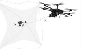
DroneHunter drone net capture system. (Photo: Fortem Technologies)
FAA regulations
The FAA regulations for UAVs are fairly easy to understand, and it would probably take an intentional effort to fly unauthorized into restricted airspace. Otherwise, stay at or below 400 ft, don’t exceed 100 mph, don’t go where you shouldn’t, file a flight plan — ask permission using the automated FAA LAANC online tool — but always stay within visual range of the UAV. Those are most of the basics. Additionally, to operate a UAV commercially, you must also register it with the FAA and install an electronic device to tell everyone in the surrounding airspace the drone’s registration number, which is traceable to the owner/operator. Never fly near clouds, comply with local rules when flying recreationally, and never, ever fly into restricted airspace, particularly around airports, without prior authorization.
These multiple reported UAV incursions violate FAA regulations, so it is reasonable to assume the operators are deliberately flying illegally. Recreational flying requires the operator to see the UAV at all times — so flying at night is not legal either, as the rules state not to fly an hour after sunset or an hour before sunrise. Operators in restricted airspace are committing a crime punishable by fines and/or years in prison. Yet they still fly, so are they nuisance operators who don’t care or is the activity criminally motivated or orchestrated offshore?
Utilizing UTM
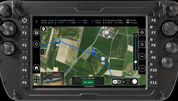
Would the coming unmanned aircraft system traffic management (UTM) have been able to keep these intruders away? I am not sure, but UTM is designed to manage UAV traffic, so presumably, it could manage these UAVs to comply with traffic requirements. However, these intruders are already ignoring existing laws, so UTM may more readily enable the identification of rogue UAVs and operators. Recent tests at the FAA/NASA UTM test range in North Texas have drawn huge interest from Walmart and Amazon, as they push to get UAV package delivery working. Wing now delivers for Walmart using a production UTM system in Dallas and Fort Worth, Texas.
To wrap this up, amongst many recently reported unidentified flying objects, several have been identified as probable UAVs, and some of those over restricted areas could be detected and managed with existing technologies. FAA regulations ban flights in restricted airspace unless approved — i.e., working in coordination with those ground facilities. There are UTMs for UAVs already being used commercially, which could assist in managing all UAVs.
Unmanned Traffic Management (UTM) is an air traffic management system for UAVs and other unmanned air taxis or similar aircraft. In the United States, this is in airspace below 400 ft, avoiding other airborne traffic — including other UAVs — and informing authorities of your intended flight plan and how you execute it versus the posted plan.
Where are we on getting such a system? Well, there is an entire directory of nearly 80 UTM suppliers, mostly commercial outfits that offer UAV traffic control of some description for some application – typically like surveying a limited area for construction or maybe a related military application. Few companies possess “full function” UTM capabilities, along with extensive expertise and experience. Each commercial flight needs the approval of the FAA, so software packages include an FAA application to fly and feedback of authorization for the flight plan, as well as approval of operator certification and UAV type. There are complex packages from third-party sources, including NASA-developed UTM, as well as independent commercial systems.
So, how would that work across a major geographical area, such as the entire United States? The FAA and NASA have been working to establish how it could work, at least at a test site in Dallas, Texas.
First, the industry participants in this trial who wanted to operate in the same area had to accede to cooperate. Agreements were signed and means were established for data to flow between the participants, their drones and the FAA (the North Texas Shared Airspace Implementation). The limits of the area near Dallas/Fort Worth for the trial were established as the boundaries in which the parties would fly and, in this case, complete deliveries. The players are Walmart, Amazon, Wing, Manna and ANRA, with FAA and NASA watching carefully.
One of the principal actors in Air Traffic Management (ATM) is ANRA in Washington D.C., with offices in London, UK, and New Delhi, India. With more than 100 customers in 15 countries and more than 200 projects, their UTM/ATM systems are gaining wider experience in several different airspaces and differing traffic compositions. The system is evolving with wider applications as installations worldwide meet new requirements. AAM for eVTOL passenger-carrying aircraft provides mission planning, traffic deconfliction, vehicle tracking, constraints management, route authorization and vehicle registration. EVTOL aircraft will likely fly not only in and out of existing airports but also from new Vertiports specially built for short-hop eVTOL flights across cities. ANRA has already engineered a Vertiport Management System (VMS) to control unmanned and autonomous access to airports and Vertiports alike.
Another unrelated development in the world of UAVs is the phenomenon of high-altitude platform station (HAPS) UAVs and their ground infrastructure. Although flying at altitudes on the edge of space, it is likely special provisions would be required within its associated UTM system to keep track and warn other high-altitude flyers. Nevertheless, the highest-flying commercial aircraft would probably be at an altitude nearly 30,000 ft below HAPS remote Stratospheric perch.
Airbus Zephyr HAPS. (Photo: Aalto)
Airbus company Aalto Haps, based in Farnborough, UK, is now responsible for the manufacture, operation and commercialization of the Airbus Zephyr HAPS vehicle line. Designed to fly for months at a time, with wings covered in solar cells for power, Zephyr has established a world record of 64 days on station in the Stratosphere, and aalot has a target to fly for 200 days regularly.
So, what do you do with such a high-altitude, long-persistence platform? Well, it is like having your own satellite, which you can hang payloads on for tasks such as surveillance, disaster assessment and relief, border control, and numerous precision GNSS applications. With an apparent footprint of close to 3,000 square miles and an appropriate communications relay capability, you have a cell-phone tower in the sky. Perhaps even a partial equivalent to the Space-X Starlink space-based satellite communication service for provision of voice and internet, but seemingly far less infrastructure than the conventional 250 ground cell-towers needed for such an area.
Places starved of phone and internet service — such as Africa — could greatly benefit from flying their kite and gaining wide area coverage. To demonstrate how this capability would work, Aalto recently established a presence in Laikipia, Kenya, building an AALTOPORT ground facility and working with the Kenyan civil aviation authority to qualify Zephyr and its communications role for operations in Kenyan airspace. It is, of course, opportune that Kenya’s location on the equator provides access to one of the most sunny days available to power Zephyr at altitude. Laikipia County is also on a raised plateau, providing Zephyr with an altitude advantage for initial launch. Incidentally, Aalto flew Zephyr for 13 days over Kenya to prove the point.
With the facility in the UK able to build Zephyr-like UAVs every three months or so, Aalto aims to establish a number of hubs (such as the one in Kenya) around the world and operate a number of HAPS aircraft continuously, providing communications and all sorts of services commercially.
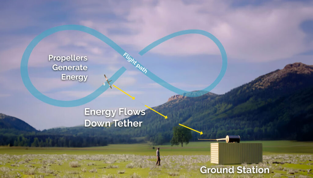
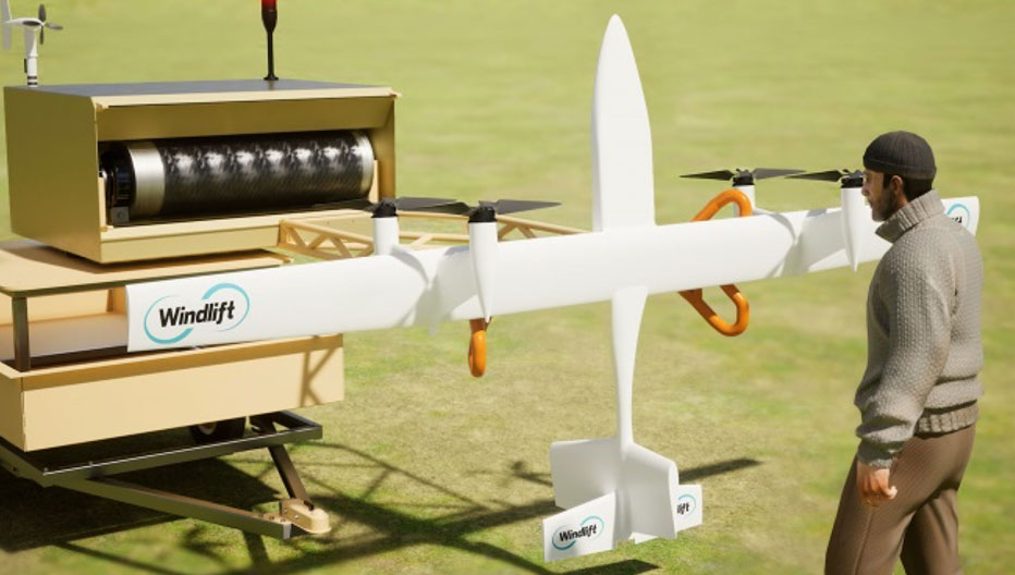
A new startup is investigating the concept of putting a tethered drone in the air with specially designed propellers driven by electric motors. This combination then turns into electricity generators for a particular flight pattern.
Windlift power generation cycle. (Photo Windlift)Transportable power generation. (Photo Windlift)
Initially focused on propeller design, Windlift was established in 2006 and is still based in Durham, North Carolina. Its approach is to use UAVs as a power source — flying repeatedly in a figure of eight, potential energy is converted to electricity in several non-powered phases of flight. The specially designed rotors turn to capture energy in those phases and their prop motors become generators of electric current, which is passed to the ground through the tether wire, to be ultimately supplied to the grid.
However, this setup could be portable, making it suitable for a small military or research team in the field needing power. This portability could be related to a $30 million contract Windlift has received from the U.S. Naval Research Laboratory, which is interested in technologies that the Navy and Marine Corp could use. Under the contract, the building and testing of a working prototype and demonstration to the Department of Defense is required. According to Windlift, this is a successful result of several earlier, smaller Small Business Innovation Research contracts to helped develop the necessary technological elements of today’s system.
Commercially, the UAV power generation approach appears to be extremely cost-effective versus the costs associated with today’s wind farms of huge wind turbines. Not only is the construction cost of each tower, its generator, and the huge blades very high, but the wear and tear of operations over time require expensive maintenance. Meanwhile, the UAV, while still in its infancy with lots of reliability and weatherproofing to be accomplished, has the potential to reduce power generation costs by up to 80%, Windlift said.
This month’s UAS news indicates how UTM is well along the path towards managing UAV integration into the National Airspace System, HAPS high-altitude aircraft may be back in the news as Aalto moves forward with commercialization plans, and yet another application for UAVs appears to involve a new potential approach for power generation. A pretty wide range of unmanned requirements and applications.