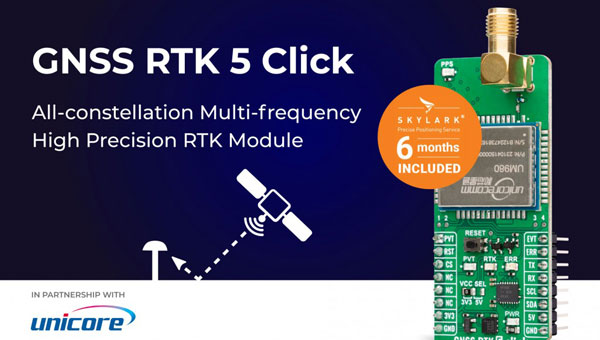
MIKROE has unveiled the GNSS RTK 5 Click, a compact add-on board for high-precision positioning and navigation demands. It features the UM980, an all-constellation multifrequency RTK positioning module from Unicore, with the advanced NebulasIV SoC for enhanced performance.
It supports Swift Navigation’s Skylark precise positioning service, multiple GNSS constellations, and RTK positioning for centimeter-level accuracy. The board also features JamShield technology for robust performance in challenging environments, USB connectivity for easy configuration and visual status indicators for module status and GNSS signal reception.
It can be used for a variety of applications, including surveying and mapping, precision agriculture, UAVs, autonomous robots and autonomous driving.
NATO has selected SandboxAQ as one of approximately 70 companies to participate in the 2025 Defense Innovation Accelerator for the North Atlantic (DIANA) cohort. The selection process involved more than 2,600 submissions from 32 NATO countries. DIANA, established by NATO in 2023, aims to address complex societal challenges by bringing together innovative companies developing dual-use technologies for both commercial and defense applications.
SandboxAQ will join the cohort’s Sensing & Surveillance group, focusing on the development of its AQNav magnetic navigation system. AQNav is designed to provide a secure navigation alternative that does not rely on GNSS, making it resilient against jamming and spoofing. The system utilizes SandboxAQ’s proprietary Large Quantitative Models (LQMs), quantum sensors, and the Earth’s crustal magnetic field to offer an all-weather, day and night, terrain-agnostic navigation solution for military and commercial applications.
The AQNav system has undergone extensive testing, including more than 200 hours of flight tests with the U.S. Air Force, involving more than 40 sorties across various geographies and aircraft types1. In July 2024, AQNav demonstrated its capability to serve as a primary navigation source and showed potential for scalability across similar aircraft types without individual calibration.
As part of the DIANA program, SandboxAQ will receive resources, insights and developmental support to advance AQNav’s capabilities. The company will also have opportunities to test the system in specialized environments, leveraging DIANA’s network of experts in technology, commercial development and defense.
“This partnership draws on the strengths of both organizations,” said GPSIA Executive Director Lisa Dyer. “Positioning and navigation are critical to today’s automotive industry and the millions of workers and families who depend on vehicles for work, to transport their loved ones and to connect with the world around them. Future positioning and navigation satellite systems operated from low-Earth orbit will be key enablers for connected vehicles.”
GPSIA’s network now includes 13 national organizations and industry leaders, such as John Deere, Garmin, Trimble, Apple, Lockheed Martin and TrustPoint. The Alliance for Automotive Innovation brings deep expertise in the automotive sector and a strong commitment to advancing safer, smarter personal transportation technology. This addition aims to strengthen GPSIA’s commitment to fostering innovation, creativity, and entrepreneurship in GNSS and related space-based position, navigation and timing (PNT) technologies.
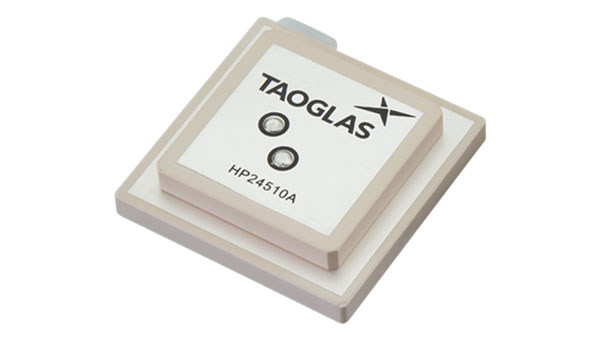
Taoglas has released a new family of active, multi-band GNSS antennas. Levity Series’ AHP24510 (L1/L2/L-Band) and AHP54510 (L1/L5/L-Band) directional patch antennas are designed for GPS, Galileo, GLONASS and BeiDou satellite constellations.
These antennas offer improved performance through triangulation across multiple satellites, offering faster and more accurate signal acquisition and lock, specifically in urban environments. The L-Band capability allows compatibility with high-precision GNSS correction services, potentially achieving positioning accuracy better than 200 cm.
The multi-band antennas seek to offer integral redundancy to minimize satellite security blind spots and reduce energy consumption due to faster acquisition requiring less system uptime to save power.
The Levity Series active antennas feature a 45 mm x 45 mm x 10 mm wide-band, dual-stacked patch design with a dual-feed, low noise amplifier, providing 28 dB to 29 dB gain and filtering. They operate with a maximum antenna VSWR of 1-to-1 from 1,207 MHz to 1,603 MHz, and the passive antenna efficiency ranges from 39.93% to 68.51% in the L1 band. These antennas use right-hand circular polarization to mitigate multi-path interference.
The Levity Series includes other multi-band products for high-precision applications, such as the HP24510A and HP54510A stacked-patch passive components, and the TFM.120A surface-mount front-end module, which covers the full multi-band GNSS spectrum including L-Band.
These antennas are suitable for various applications, including wearables, transportation, robotics, precision agriculture and autonomous vehicles.
The Directorate of Defense Trade Controls (DDTC) has changed the regulatory status of Controlled Reception Pattern Antennas (CRPAs) for position, navigation and timing (PNT). Starting September 2025, CRPAs will no longer be subject to the International Traffic in Arms Regulations (ITAR). Instead, they will be reclassified under the less restrictive Export Administration Regulations (EAR) list, which is under the jurisdiction of the Department of Commerce.
The rule, in part, removes items from the U.S. Munitions List (USML) “that no longer warrant inclusion.” According to the rule, “certain anti-jam antennas no longer provide a critical military advantage, with increasing commercial utilization applicable to civil GPS resiliency.” By removing CRPAs for PNT, “the Department intends to facilitate civil global navigation system resiliency.”
The recent regulatory change is expected to significantly impact several industries, including airlines, autonomous vehicles, UAVs and critical infrastructure applications, which can benefit from the increased availability of CRPAs. Additionally, this change may open the U.S. market for CRPA manufacturing, potentially resulting in swift technological advancements and lower costs.
The importance of CRPAs lies in their ability to protect GNSS receivers from interference and jamming. GNSS signals are inherently weak and susceptible to both deliberate and unintentional interference. CRPAs work by adjusting their reception pattern to create nulls in the direction of interfering signals while maintaining reception from desired satellite signals. This adaptive beam steering capability allows CRPAs to effectively eliminate signals from particular directions while preserving signals from others, making them a powerful tool in ensuring the reliability of GNSS-dependent systems.
Topcon Positioning Systems has expanded its Topnet Live reference station network by adding 200 new geodetic stations across the United States. This expansion enhances the availability of centimeter-level accuracy for industries requiring precise positioning, such as engineering, surveying, construction and agriculture.
The upgraded network provides advanced network corrections that optimize operational workflows in various sectors. The enhanced infrastructure supports emerging technologies such as automated turf management, precision line marking, imaging systems and UAV operations for mapping and delivery.
This expansion builds upon previous efforts throughout 2024, resulting in a 30% increase in Topnet Live’s total coverage in the United States. The network now offers comprehensive, network-modeled solutions that cater to a wide range of professional requirements across multiple market segments.
The Topnet Live network utilizes Networked Transport of RTCM via Internet Protocol (NTRIP) to stream GNSS corrections data via the Internet for RTK positioning. This technology allows for centimeter-level accuracy by mitigating errors from factors such as ionospheric disturbances, satellite clock deviations and orbit inaccuracies.
Septentrio has introduced the mosaic-G5 series, a new range of GNSS receiver modules tailored for robotics and other applications requiring compact components.
These modules represent a significant advancement in size and power efficiency, offering a 60% reduction in size and 40% lower power consumption compared to the mosaic-X5 receiver while maintaining high performance standards. This improvement enables reliable, high-accuracy positioning for devices where minimal size, weight, and power are critical, such as commercial UAVs, compact industrial robots, and high-performance handheld devices.
The mosaic-G5 series expands Septentrio’s existing mosaic portfolio, known for its all-band GNSS technology and robust performance in accuracy, reliability, and resistance to jamming and spoofing. This broad product lineup provides users with the flexibility to select the most suitable module for their specific design requirements.
The mosaic-G5 modules will be gradually released throughout 2025.
CHC Navigation (CHCNAV) has introduced the X500 rotor UAV, designed for precision aerial operations. It is ideal for surveying, urban monitoring, emergency response, disaster relief and infrastructure inspection.
Equipped with advanced navigation and safety features, the X500 rotor UAV meets the demands of professional operations. Dual GNSS and triple inertial measurement unit redundancy enhance positional accuracy and reliability, whereas integrated millimeter-wave radar provides precise obstacle detection. The drone’s video transmission system supports HD feeds over distances of up to 20 km, and its V-SLAM visual positioning ensures accuracy for tasks such as landing on moving platforms.
The X500 is designed to handle diverse payloads, with a capacity of up to 5 kg and flight durations of up to 58 minutes — or 50 minutes when equipped with the CHCNAV AA10 lidar system. Its open SDK and compatibility with the Mavlink protocol allows for seamless integration with both CHCNAV sensors and third-party equipment. Built for demanding conditions, the X500 features an IP55 rating and can operate in winds up to 12m/s.
The UAV features a new power system, enabling up to 58 minutes of flight time. According to CHCNAV, the BS10 charging station minimizes downtime by charging six batteries from 20% to 90% in just 40 minutes, while hot-swappable batteries ensure uninterrupted operations during extended missions.
Complementing the X500’s hardware is CHCNAV’s SmartGo ground control software, which simplifies mission planning and offers real-time flight monitoring. With various flight path options and beyond visual line of sight capabilities, SmartGo ensures safe, efficient operations while providing full control over mission parameters.
Containers, stillages, trailers or reusable transport packaging — non-powered assets such as these play a central role in smooth supply chains and logistics processes. For a long time, however, non-powered assets could hardly be digitized due to a lack of sufficient battery life, thus eluding efficient management.
To plan and control logistical processes and supply chains, companies usually needed a large buffer/reserve stock and sometimes a lot of telephone/administrative work to determine the exact location and condition of such assets. Thanks to power-saving Internet of Things and wireless technology paired with high-performance sensors for environmental conditions and intelligent firmware, sufficiently robust trackers are now available for efficient use in the mass market.
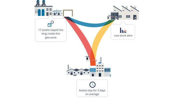
Figure 1: Integrated modeling tools help to model and track the flow of assets across operations and locations.
The basics: Thousands of tracker data at a glance
In order for companies to derive real benefits for their business from pure tracking, they need a management platform that can do more than display the trackers on a map. Depending on the requirements, tracking hardware can be equipped with sensors for temperature, humidity or tipping movements, for example.
A management platform must then ensure that the multitude of trackers can be efficiently commissioned and administered and that their collected data is made available for use. After all, large amounts of data are only valuable if important insights can be gained quickly and intuitively. The tracking application, therefore, needs powerful search and filter functions and visually meaningful maps, dashboards and panels.
Integration into existing systems
However, for the data collected via tracking to fully benefit the company’s supply chains and logistics processes, it needs to be integrated into the company’s existing IT systems, such as ERP systems or tools for data analysis and business intelligence.
The data exchanges between the business applications can be useful in both directions: on the one hand, precise localization and sensor data from the tracking platform enrich reliable enterprise resource planning via the ERP system; on the other hand, it can be helpful to make data from the ERP system available to the tracker management platform — for example, to evaluate the utilization of a trailer or to simply display the contents of a container via a mobile app on-site.
Technically, such data exchange can be realized through open APIs (application programming interfaces), which such a management platform should have. This enables the professional implementation of system integrations that are needed in the business IT of many companies — for example with SAP, Microsoft Azure or AWS.
Designing/modeling process flows and making route patterns transparent
In order for companies to make their own processes around tracked assets transparent, a management platform needs tools that can be used to model and track the flow of assets across the different processes and, if applicable, locations (see Figure 1). Also important for this is the ability to define specific geographic areas of interest. Such geo-zones can then be used for inventory management, flow analysis or alerts. The mapping of load carriers or other assets to companies’ logistical processes and supply chains provides an accurate overview of how individual assets move from location to location, where they stop and for how long.
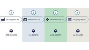
Based on the collected data, route patterns and travel times can be identified, rotation statistics with average and outlier analyses can be created (see Figure 2), and finally, planning and forecasts can be adjusted based on measured historical data. For appropriate visualization and evaluation, the tracking platform should provide the appropriate tools. This way, statistics can be generated for thousands of assets and/or an entire fleet, which can serve as a basis for further process optimization.
Figure 2: With a high-performance tracker management system, route patterns and travel times can be detected, and rotation statistics can be generated so that averages and anomalies can be identified.
Airbus example
Airbus develops, manufactures and delivers aerospace products, services and solutions worldwide, with more than 50,000 dedicated returnable transport packages circulating between sites and subcontractors. Thousands of returnable transport packages have been equipped with trackers and managed via a cloud-based platform over the past years. Airbus therefore benefits today from complete transparency. Inventory runs automatically, and stocks can be easily retrieved with their locations. The rotation capability of the packages has been improved, while their storage times and the circulating stocks have been reduced. Fleet capacity can also now be optimized, spare parts costs saved and subcontractor compliance better monitored.
The advantages at a glance
Precise inventory management of all mobile assets, from containers to returnable transport packaging to construction machinery.
Reliable condition monitoring: Continuous monitoring of environmental conditions such as temperature and humidity creates transparency — e.g., for compliance agreements.
Optimal process flows: Route patterns and turnaround times become transparent and anomalies easily identifiable, so that warnings can be sent in time and processes optimized overall.
Utilization monitoring: The utilization of each load carrier and each asset in a fleet can be precisely determined and optimized.
Predictive maintenance: Thanks to continuous monitoring, the maintenance of monitored assets can be planned and carried out in advance — before a breakdown interrupts important business processes.
Protection against theft: Lost or stolen assets can be easily recovered, so that financial damage can be minimized, especially in the case of expensive specialized assets.
Honeywell and NXP Semiconductors have expanded their partnership to advance aviation technology and autonomous flight capabilities. This collaboration merges Honeywell’s aerospace expertise and Anthem avionics system with NXP’s high-performance computing architecture to develop AI-driven aerospace technologies.
The partnership aims to enhance operational efficiency in flight planning and management while facilitating smoother transitions to new chipsets and technologies. The companies will focus on developing next-generation cockpit displays with improved visual clarity and system efficiency. They are also working on simplifying migrations to newer avionics technologies and extending the lifecycles of critical aviation systems, according to Honeywell and NXP.
NXP’s domain-based architecture, which includes high-compute capabilities, integrated cybersecurity and functional safety, will be adapted for aviation applications on Honeywell Anthem, the industry’s first cloud-connected cockpit system. This builds upon the companies’ collaboration in building management, fire safety and security products.
For aerospace applications, Honeywell will utilize various NXP processors, including the i.MX 8 applications processors and S32N super-integration processors. These processors will enable Honeywell Anthem to deliver faster data processing for real-time AI-driven insights, potentially enhancing safety and optimizing performance both in flight and on the ground.
Vertical Aerospace, a leader in electric vertical take-off and landing aircraft development, is set to be an early adopter of this collaborative technology, incorporating it into its piloted VX4 prototype aircraft.
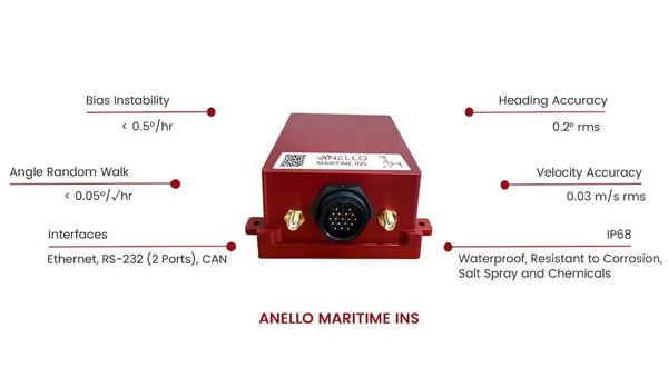
ANELLO Photonics has introduced its Maritime inertial navigation system (INS). The system integrates ANELLO’s Silicon Photonic Optical Gyroscope (SiPhOG) technology with an advanced sensor fusion engine, offering high-precision navigation for autonomous surface and underwater vessels.
The ANELLO Maritime INS combines optical gyroscope performance and silicon photonics technology, resulting in a compact, low-power consumption device designed for GPS-challenged environments. Its capabilities include reference-grade position, velocity and attitude data output at 100Hz, and a high-precision three-axis SiPhOG with less than 0.5°/hr unaided heading drift.
This system incorporates dual triple-frequency GNSS receivers with static heading capability and an AI-powered sensor fusion engine with GNSS spoofing detection. The INS provides accurate dead reckoning and is designed to withstand harsh maritime conditions, being waterproof and resistant to corrosion, salt spray, and chemicals. The system’s applications extend beyond maritime use, with potential benefits for industries such as construction, agriculture, robotics and defense.
Hexagon has entered an agreement to acquire Septentrio, a move aimed at advancing resilient assured positioning solutions across various industries.
The integration of Septentrio’s GNSS platform with Hexagon‘s positioning technologies aims to enhance accessibility to high-accuracy positioning solutions with reduced size, weight and power requirements. This acquisition is expected to impact various sectors, including robotics, UAVs and other autonomous systems, by providing improved positioning capabilities.
According to the company, Septentrio, based in Leuven, Belgium, employs approximately 150 people and is projected to generate over 50 million euros in revenue in 2024. The transaction, subject to regulatory approvals, is expected to be completed in the first half of 2025.
Following the acquisition, Septentrio will continue its current business model, supplying GNSS technology to its existing OEM users. The company will be incorporated into Hexagon’s Autonomous Solutions division. It is anticipated to have significant implications for the positioning industry, potentially setting new standards for accuracy, resilience, and scalability in positioning technologies.