Swift Navigation and Quectel Wireless Solutions have partnered to enhance GNSS accuracy across various industries. This collaboration integrates Swift’s Skylark Precise Positioning Service with Quectel’s high-precision GNSS modules.
Skylark, a cloud-based GNSS corrections service, is designed to improve standard GNSS accuracy from several meters to a few centimeters. It utilizes advanced atmospheric modeling and a carrier-grade network to provide reliable, scalable, and high-integrity precision.
The partnership offers three Skylark variants: Skylark Cx , Skylark Nx RTK and Skylark Dx. Each variant is tailored to meet specific industry requirements and can be paired with Quectel’s GNSS modules for various applications.
Integration and Applications
Automotive: Quectel’s LG69T module with integrated inertial measurement units combined with Skylark Cx offers lane-level accuracy for intelligent driving systems.
Outdoor Robotics: The LG290P module paired with Skylark Nx RTK offers centimeter-level accuracy for autonomous robots such as robotic lawnmowers.
Micromobility: Quectel’s LC29H module with Skylark Dx achieves decimeter-level accuracy for e-bikes and scooters in urban areas.
UAVs: The LG290P module with Skylark Nx RTK offers high accuracy for fast-moving UAV applications.
Quectel’s LG290P is a quad-band GNSS module designed to deliver high performance for demanding applications, ensuring RTK availability and quality even in challenging environments. When paired with Skylark Nx RTK, the LG290P achieves the centimeter-level accuracy needed to ensure the precision required for applications such as precision agriculture, robotic lawnmowers, surveying and personal robots.
The LC29H module is a dual-band multi-constellation solution with optional dead-reckoning capabilities that supports seamless integration with all Skylark variants and comes in a standard 12.2mm × 16.0mm footprint. Developers can transition from standard positioning to high-precision GNSS without hardware changes while choosing the Skylark variant that meets their specific requirements.
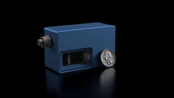
Voyant Photonics has introduced the Carbon frequency modulated continuous wave (FMCW) lidar sensor. It features lidar on a chip with solid-state beam steering integrated into a fingernail-sized silicon photonic chip. The Carbon sensor offers high-resolution imaging with millimeter precision and object detection capabilities up to 200 m.
FMCW technology enables instant velocity measurement at each point, in addition to distance, reflectivity and intensity data. This 4D capability allows for high-fidelity point cloud data generation, providing a real-time view of the environment up to 20 times per second, according to Voyant Photonics.
The sensor’s performance is notable in various environmental conditions. It can operate effectively through dust, fog, rain, and snow and is immune to sunlight interference, particularly during sunrise and sunset. Additionally, it is not affected by highly reflective objects such as street signs, traffic cones and safety vests.
The Carbon sensor seeks to enhance machine perception capabilities across various industries, including industrial automation, robotics and security applications. Its software-defined lidar feature allows users to modify the frame rate and adjust the field of view during operation.
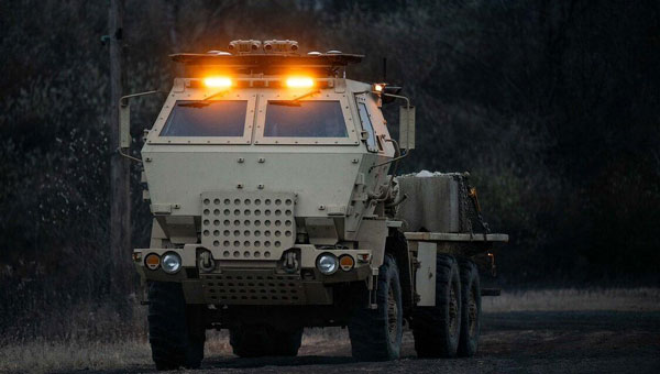
Lockheed Martin has demonstrated an uncrewed capability with a surrogate HIMARS launcher. On Dec. 4, 2024, the company showcased the launcher’s ability to navigate autonomously using non-emitting perception sensors, enabling seamless day and night operations without a human crew.
This advancement marks a substantial step toward integrating autonomous solutions into the existing HIMARS fleet, supporting the U.S. Army’s modernization efforts for artillery capabilities. The technology offers enhanced adaptability in complex environments and aligns with Lockheed Martin’s 21st Century Security vision.
The autonomous HIMARS system is designed to be easily integrated into existing platforms, maximizing the Army’s investment while retaining the option for crewed operations. This flexibility allows for adaptation to changing mission requirements and supports all-domain deterrence.
Looking ahead, the Army envisions pairing manned HIMARS with autonomous wingman launchers for more efficient artillery operations. A follow-up demonstration is scheduled for the latter half of 2025.
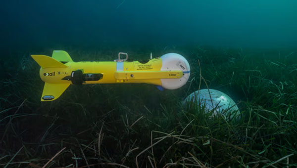
Unmanned surface vessels (USVs) are becoming a reality for many sea-going countries around the world. Belgium and The Netherlands have partnered to acquire a proven autonomous mine-clearing solution supplied by Exail Technologies in Paris, France.
A nearly $60 million contract awarded in July 2024 by NATO will allow Exail to deliver several hundred K-STER underwater vessels, which can find and destroy both floating and anchored mines.
Equipped with a shaped charge, the unmanned underwater vehicle (UUV) is launched from a safe distance by a minesweeping ship, currently undergoing sea trials – the Oostende new generation minesweeper. Similar to the Kamikaze aerial drone, it autonomously seeks out a mine at a predetermined location and destroys it.
K-STER UUV encounters. (Photo: Exail)
Meanwhile, as the war in Ukraine continues, drone warfare continues to evolve. Ukraine has developed electronic warfare systems that have progressed from merely jamming control signals and GNSS navigation to actually spoofing GNSS guidance. These systems overcome direct satellite signals with a stronger signal, providing gradually changing guidance to the drone, ultimately steering it back toward Russian-friendly Belarus.
Several recent intense Russian drone attacks were with tens — and even hundreds — of Iranian Shahed attack dones. 151 were spotted in November alone, 148 of which were Shahid drones that carry an 88 lb explosive warhead. On November 26, the Ukrainian Air Force reported that Russia attacked with 188 Shahed drones along with a few Iskander-M ballistic missiles. Ukraine responded with aircraft, helicopters, shells fired from fixed ground installations, and signals designed to jam drone electronics and guidance systems. Around 80 attacking drones succumbed to these Ukrainian defenses.
In addition, electronic GNSS spoofing of more than 90 drones diverted them from their targets – this implies a widespread array of electronic resources that intercepted in-flight drones coming from Russia. Diverted from their planned tracks to their targets, these drones will crash when they eventually run out of fuel. In a large number of cases, the ground defense systems were able to steer the attackers toward Russian-friendly Belarus, where they also crashed when fuel was exhausted. So perhaps less than 50% of this specific attack resulted in the use of precious Ukrainian ordinance, a good sign for future defense capabilities.
Meanwhile, on the other side of the “Pond” (Atlantic Ocean), British and U.S. forces at bases in Southern England have been dealing with an uninvited invasion of overflying drones, somewhat similar to reported incursions over airforce bases (AFB) in the U.S., such as Langley AFB.
RAF Lakenheath is a joint UK/US base used by the US 48th Fighter Wing and is thought to also house NATO’s nuclear weapons – this base is one of four that is thought to have been harassed by drone overflights. Other UK bases which now also have heightened security include RAF Lakenheath, RAF Mildenhall, and RAF Feltwell in the Southeast and RAF Fairford in Southwest England. We might speculate that the drones could be collecting Video and maybe Lidar information on assets on the ground, but surely this has already been gained by spy satellites belonging to Russia and China, the principal suspects for these incursions — so what exactly could be the intent?
The incursions were happening at the same time that Ukraine was using UK Storm Shadow missiles against Russia. Some speculate that this might be a demonstration of capability by Russia, indicating an ability to quickly, without any opposition, gather a number of drones and fly them over UK NATO bases. Whilst unarmed for this demonstration, in the future, they could wreak havoc on aircraft and personnel. A number of criminal investigations are apparently underway to determine who was responsible.
Swift Navigation has collaborated with CHC Navigation (CHCNAV) to integrate Swift’s Skylark Precise Positioning Service with CHC Navigation’s GNSS receivers.
Skylark is a cloud-based GNSS corrections service designed to improve the accuracy of standard GNSS from several meters to a few centimeters. Built to meet stringent standards for automotive safety (ISO 26262), Skylark supports more than 10 million advanced driver-assistance systems (ADAS)-enabled and autonomous vehicles globally. It can be used in a variety of applications, such as autonomous vehicles, robotics and surveying equipment.
Example integration
The CHC CGI-220 Pro is a high-precision, automotive-grade GNSS/INS tightly coupled navigation system designed for applications requiring robust and accurate positioning, such as autonomous driving, ADAS and intelligent transportation systems. When integrated with Skylark, the CGI-220 Pro offers:
Centimeter-level accuracy: Skylark enhances the CGI-220 Pro’s precision, delivering reliable, real-time positioning even in challenging environments.
Seamless integration: The CGI-220 Pro’s compact design and compatibility with various vehicle systems allows for straightforward integration into automotive platforms.
High reliability: Engineered to meet stringent automotive standards, the CGI-220 Pro offers consistent performance under demanding conditions.
Unidentified UAVs over military installations have sparked security concerns across the United States. Numerous sightings of suspected drones have been reported over residential areas, restricted sites and critical infrastructure, including reservoirs, electric transmission lines, rail stations, police departments and military bases. These incidents have prompted federal agencies to investigate and address increasing public concerns.
Government response
John Kirby, the White House national security spokesperson, provided an update regarding the recent drone sightings across the United States. According to Kirby, more than 5,000 drone sightings have been reported in recent weeks, but only about 100 of these required further investigation.
Kirby said the sightings have included a combination of lawful commercial drones, hobbyist drones and law enforcement drones, as well as some crewed aircraft and stars mistaken for drones.
However, the U.S. government is implementing precautionary measures. UAV detection and tracking systems are being installed at Picatinny Arsenal and Naval Weapons Station Earle in New Jersey. The FBI is spearheading investigations into the sightings, and local law enforcement agencies are conducting their own inquiries as well, CNN reported.
Several military installations have reported drone activity, including:
Picatinny Arsenal in New Jersey confirmed 11 unauthorized drone flights over its airspace.
Naval Weapons Station Earle in New Jersey has also reported drone sightings.
Ramstein Air Base in Germany experienced drone activity in early December 2024.
In an interview with ABC News, Alejandro Mayorkas, head of the Department of Homeland Security, said, “There’s no question that drones are being sighted.”
Impact on daily operations
The drone sightings have affected civilian infrastructure as well. Stewart International Airport in New York temporarily closed its runways for about an hour due to reported drone activity. Residents in several East Coast states have also reported seeing hovering and low-flying bright lights at night.
While the increase in sightings has raised concerns among residents and lawmakers alike, federal authorities maintain that most of these incidents do not pose a significant threat to public safety or national security.
VIAVI Solutions has signed an agreement to acquire Inertial Labs for $150 million. The acquisition, subject to certain regulatory approvals and customary closing conditions, is expected to close in the third quarter of fiscal 2025 and has a potential for up to $175 million in contingent payments throughout the next four years.
This acquisition is expected to significantly boost VIAVI’s financial performance, with projections indicating an increase of approximately $50 million to the company’s Network and Service Enablement (NSE) annual revenue in 2025. Inertial Labs brings to VIAVI a comprehensive portfolio, including inertial measurement units (IMU), inertial navigation systems (INS), assured positioning navigation and timing (APNT), GNSS tracking, lidar scanning, alternative navigation (ALTNAV) and visual navigation solutions. These offerings complement VIAVI’s existing PNT and other aerospace and defense solutions.
According to VIAVI Solutions, the acquisition is designed to open up new opportunities for VIAVI in emerging markets. Inertial Labs’ expertise in utility inspection through lidar and photogrammetry algorithms, as well as smart system navigation for airborne and autonomous ground vehicles, is expected to accelerate VIAVI’s entry into industrial and autonomous delivery and transportation end markets.
“With a highly complementary product portfolio focused on alternate navigation solutions, this transaction supports VIAVI’s strategy to expand our presence in domestic and international aerospace and defense segments and accelerates our entry into autonomous air, land and sea systems in the military and industrial end markets,” said Oleg Khaykin, president and CEO of VIAVI.
“We are excited that our expertise, precision solutions and resources provide expansion opportunities for VIAVI in high growth markets and applications such as drone-based lidar and camera systems,” said Jamie Marraccini, president and CEO of Inertial Labs.
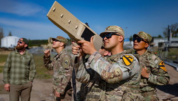
The U.S. Department of Defense (DOD) has unveiled a comprehensive classified strategy for countering unmanned systems. This strategy, signed by Secretary of Defense Lloyd J. Austin III, seeks to address the evolving threats posed by unmanned systems in both current and potential future threats.
Key components of the strategy
This strategy is based on various DOD initiatives, such as the Joint Counter-Small UAS Office, the Warfighter Senior Integration Group, and the Replicator 2 initiative. It also appoints NORTHCOM and INDOPACOM as the lead coordinators for counter-UAS operations, promoting a unified effort in domestic and international airspace.
The strategy identifies five primary objectives:
Improving the detection and characterization of unmanned system threats.
Disrupting and weakening the networks to facilitate the proliferation of unmanned systems.
Defending U.S. interests by incorporating counter-unmanned systems into essential warfighting capabilities.
Providing solutions that enhance speed, adaptability, and scale.
Prioritizing counter-unmanned systems in the design and development of future joint forces.
To achieve these objectives, the DOD plans to launch deliberate campaigns to counter threat networks in partnership with other U.S. departments and agencies, enhance both active and passive defenses, clarify authorities and embed defense measures across military doctrine, training and policy. Additionally, it aims to leverage rapid acquisition approaches and partnerships with industry and allies.
A key component of this strategy is the Replicator 2 initiative, announced in September 2024. This effort focuses specifically on countering small drone threats to critical installations and force concentrations. The Pentagon aims to seek funding for Replicator 2 in the fiscal 2026 budget request, with the goal of fielding improved counter-drone capabilities within 24 months of receiving congressional funding.
AEVEX Aerospace has acquired Veth Research Associates (VRA), a veteran-owned firm specializing in navigation and autonomous systems. The partnership aims to enhance AEVEX’s capabilities in delivering solutions for unmanned systems operating in jammed and contested environments, which is essential for addressing the challenges anticipated in future conflict scenarios.
Established in 2013, VRA brings to AEVEX its intellectual property portfolio centered around a sensor fusion engine, which powers real-time autonomous decision-making using deep neural networks and machine learning. Integrating VRA’s expertise seeks to improve AEVEX’s ability to deliver autonomous hardware and software solutions, particularly combat-proven Group-II and Group III tactical UAS operating in GPS-denied or spoofed environments.
VRA’s LYNX vision-based navigation (VBN) system enables navigation independent of GPS. It features day/night capability, a modular design and open architecture, making it adaptable for use on both manned and unmanned platforms. It is currently deployed with multiple Department of Defense (DOD) and international users.
Brian Raduenz, CEO of AEVEX Aerospace, emphasized the strategic importance of this acquisition, stating, “With the addition of VRA’s leadership team and subject matter experts, we are well-positioned to lead the future of autonomous decision-making in contested environments. Their innovative sensor fusion engine will serve as the backbone of our navigation solutions as we advance into the next generation of GPS-denied capabilities.”
The automotive navigation of tomorrow is highly connected and capable of dynamically using high-resolution map information and vehicle and environmental data from the cloud. It is an enabler for powerful driver assistance, intelligent e-mobility and autonomous driving. As a global provider of software engineering services for the mobility industry, Intellias is involved in many of these developments.
Although obtaining mapping and navigation data is easier today than it was 10 years ago — thanks to dashcams, UAVs and satellites — collecting this data is still labor-intensive. Even if most corners of the world are already recorded in public and private geographic information systems (GIS), the maps still need to be maintained regularly. Data accuracy and timeliness are the two biggest challenges in the mobility industry, followed by coverage, as the physical world is constantly evolving. To meet these requirements, the evolution of navigation and digital mapping is gathering pace. The following six technology and deployment trends will drive automotive mapping and navigation in the coming years.
1. Enriching Mapping Data With AI
Satellite imagery was a breakthrough for map creation. The wrinkle, however, is that most mapping software cannot work directly with satellite photos. Visual data first needs to be codified into comprehensive navigation datasets in a suitable format such as the Navigation Data Standard (NDS). Then map owners must keep it up to date. Both processes are costly and labor-intensive, making them great use cases for artificial intelligence (AI) in mapping.
AI algorithms improve the speed and precision of digital map building by offering the ability to update maps more regularly and map new areas faster. They can classify objects in satellite images — buildings, roads, vegetation — to create enriched 2D digital maps as well as multi-layer 3D map models. With precise maps, you can delight users with better ETAs, detailed fuel or energy usage estimates, and richer point-of-interest information.
Apart from facilitating the collection of mapping data, AI can also help with generating such data. Researchers from MIT and the Qatar Computing Research Institute (QCRI) recently released RoadTagger. This neural network can automatically predict the road type (residential or highway) and number of lanes even with visual obstructions present, such as a tree or building. The model was tested on occluded roads from digital maps of 20 U.S. cities. It correctly predicted the number of lanes with 77% accuracy and predicted road types with 93% accuracy.
That said, sensor data collection from connected vehicles isn’t going anywhere. OEMs are increasingly relying on their fleets to collect new insights for digital map creation, and this process is becoming easier with advances in machine learning. HERE Technologies recently presented UniMap — a new AI-driven technology for faster sensor data processing and map creation. The new solution can effectively extract map features in 2D and 3D formats, then combine them with earlier map versions. This unified map content data model allows new digital maps to be available in 24 hours.
Photo: Intellias
2. NDS.Live: From offline databases to distributed map data systems
Conventional onboard navigation systems are designed, developed and integrated with proprietary databases, which become obsolete with every new product generation. NDS.Live is the new global standard for map data in the automotive ecosystem, promoting the transition from offline to hybrid/online navigation. It minimizes the complexities of supporting different data models, storage formats, interfaces and protocols with one flexible specification. NDS.Live is not a database, but a distributed map data system.
NDS.Live was co-developed by global OEMs and tech leaders, including Intellias, Daimler, HERE, Denso, Renault and TomTom are among those who have already adopted it. For example, second-generation Mercedes-Benz User Experience (MBUX) systems are powered by NDS.Live. The distributed map data system provides fresh information for the driver assistance system, which gets visualized as augmented reality (AR) instructions on the head-up display (HUD). NDS.Live can help massively improve the navigation experience for EVs and regular connected vehicles. It also helps OEMs deploy value-added subscriptions for assisted driving and navigation.
3. 3D and HD map generation
3D maps enable accurate rendering of physical objects in a three-dimensional form. High-definition (HD) maps feature detailed information about road features (lane placements, road boundaries) and terrain type (severity of curves, gradient of the road surface). Both types of maps are essential for launching advanced ADAS features and, ultimately, ushering in the era of autonomous driving.
3D maps define how the vehicle moves and help it interpret the data it receives from onboard sensors. Since most sensors have a limited range, HD maps assist by providing the navigation system with extra information on road features, terrain and other traffic-relevant objects.
The bottleneck of both HD and 3D mapping is collecting and rendering data. In the case of 3D maps, you need to capture video in real time from multiple cameras, plan for interference due to vibration, temperature and hardware issues, and then repeat the process across billions of kilometers of roads across the globe. Rather than doing this huge task alone, mobility players and OEMs join forces:
• HERE and Mobileye, for example, partnered to crowdsource HD mapping data collection, with VW joining later. Mobileye developed a compact, high-performance computer vision system-on-chip called EyeQ. Installed by more than 50 OEMs across 300 vehicle models, the system supplies Mobileye with ample visual data they can then render into maps with the help of partners.
• TomTom, in turn, teamed up with Qualcomm Technologies to crowdsource HD mapping insights from its users. Qualcomm provides the underlying cloud-based platform for making and maintaining HD maps from various sources, including swarms of connected vehicles.
Photo: Intellias
4. Autonomous driving simulations
Autonomous vehicles require extensive road and track tests to pass security checks. Manufacturers also need to simulate near-crash events without putting anyone in danger. Hyper-realistic virtual worlds can be much safer testbeds for autonomous vehicles (AVs) — especially as virtualization technology improves.
A group of researchers released an open-source, data-driven simulation engine for building photorealistic environments for AV training. The engine can simulate complex sensor types including 2D RGB cameras and 3D lidar, as well as generate dynamic scenarios with several vehicles present. With the new engine, users can simulate complex driving tasks such as overtaking and following.
Waymo takes a similar approach of using real-world data collected from vehicle cameras and sensors to create highly detailed virtual testbeds. The Waymo team has built virtual replicas of several intersections complete with identical dimensions, lanes, curbs and traffic lights. During simulations, Waymo algorithms can be trained to perform the most challenging interactions thousands of times, using the same or different driving conditions and different vehicles from its fleet.
To perfect the performance of the algorithm, the team uses a fuzzing technique. During training sessions, engineers alternate the speed of other vehicles, traffic light timing and the presence or absence of zig-zagging joggers and casual cyclists. Once the Waymo algorithm learns the trick of driving through a specific intersection with a flashing yellow arrow, the “skill” becomes part of the knowledge base, shared with every vehicle across the fleet.
The new generation of high-fidelity 3D environments can be built with data from different sensor types to effectively convey all details of the material world to the algorithm. Existing 3D visual databases already include realistic details for traffic signs, pavement markings and road textures. With machine learning and deep learning algorithms, complex ADAS/AD scenarios can simulate close to real-life conditions.
Photo: Intellias
5. Digital twins of road infrastructure
While OEMs leverage dashcam data collection for building better navigation systems, transportation managers use the same intelligence to digitize road infrastructure. A digital twin is an interactive, virtual representation of physical assets or systems such as a smart traffic light network or smart parking facilities. Powered by real-time data, digital twins of road infrastructure can enable advanced urban planning scenarios. This includes dynamic traffic light signal optimization to reduce congestion as well as prioritized public and service transport management and accurate traffic predictions to optimize planning, signage, construction work schedules, etc.
Low latency is crucial for autonomous driving. Yet 3D map generation on the edge requires substantial computing power. Moreover, vehicles cannot store all mapping data on their route and need to constantly receive over-the-air updates. A group of researchers has proposed placing compact map distribution devices on roadside edges to facilitate point cloud data (PCD) map delivery on the go. The results show that autonomous vehicles can perform self-localization while downloading PCD maps. This system allows autonomous vehicles to receive dynamic new maps for each new destination instead of storing tremendous data records onboard.
6. AR in HUD navigation products
The latest vehicles have an upgraded human-machine interface (HMI)design, featuring new hardware and software elements that allow for AR navigation. AR in HUDs can deliver all standard information from static displays (driving speed, status of the ADAS system, fuel or charge levels), alongside dynamic routing instructions, including information on traffic signs, speed limits, construction work alerts and ETAs.
Overall, AR navigation systems can help drivers make better decisions on the road. A recent comparative study found that drivers using AR-augmented HUDs made fewer errors and drove faster on average than those using conventional HUDs. Participants also rated AR HUD instructions as more useful and easier to understand.
The next advance in navigation will be holographic displays, offering AR instructions in 3D. Advances in lidar technologies already allow for projecting ultra-HD holographic representations of road objects in real time into the driver’s field of view. Such systems can enable shorter obstacle visualization times and reduce driving-related stress, according to Tech Explore.
Propeller Drones has secured a $7 million contract with the Israel Electric Corporation (IEC) to conduct fully autonomous UAV operations for electrical infrastructure inspection. This project marks an advancement in beyond visual line of sight (BVLOS) drone operations in Israel, as it represents the first government approval for pre-approved BVLOS flights using an unmanned traffic management (UTM) system.
Under the collaboration, Propeller Drones and FlightOps will partner to enhance AI flight capabilities that meet IEC requirements and regulatory standards. Airwayz, a company specializing in low-altitude UTM solutions, has been selected to provide the UTM system for managing drone operations.
Airwayz’s UTM system, developed by experienced air traffic controllers, integrates real-time weather and location data to optimize airspace usage and manage multiple drone fleets simultaneously. This technology allows for efficient rerouting of unmanned vehicles in case of unexpected incidents.
The collaboration seeks to address long-standing regulatory challenges in the UAV industry by demonstrating the ability to conduct large-scale autonomous operations safely and efficiently. According to Propeller, this project has the potential to open up new opportunities for drone applications across various industries, particularly for inspections in hazardous or hard-to-reach areas.
As the system accumulates flight hours and data, it is expected to contribute to the advancement of autonomous BVLOS UAV operations, potentially influencing future regulatory approvals and industry standards. Propeller shared that the success of this project could pave the way for broader adoption of autonomous drone technologies in Israel and potentially serve as a model for other countries.
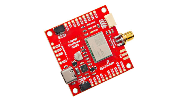
SparkFun Electronics has introduced the SparkFun Quadband GNSS RTK Breakout (Qwiic), which is designed to improve positioning accuracy using the Quectel GNSS module. This module has a compact design and compatibility with the Qwiic connector, making it easy to integrate into various projects. Additionally, it shares the same dimensions, pin layout and connectors as the SparkFun GPS-RTK-SMA Breakout – ZED-F9P, offering a seamless upgrade path for users.
The LG290P module is a quad-band, multi-constellation, high-precision real-time kinematics (RTK) GNSS receiver capable of receiving signals from multiple frequency bands: L1, L2, L5 and L6/E6. It supports all GNSS constellations and offers support for Satellite Based Augmentation Systems (SBAS) — such as Wide Area Augmentation System (WASS) and European Geostationary Navigation Overlay Service (EGNOS) — as well as precise point positioning (PPP) services, including BDS PPP-B2b and MADOCA-PPP. The module is designed to provide precise navigation with fast convergence times and reliable performance through RTCM and RTK corrections.
The module features a built-in NIC anti-jamming unit, which uses advanced algorithms to detect and eliminate interference signals. This can significantly enhance signal reception in challenging electromagnetic environments. The device can be used in complex scenarios, such as urban settings or areas with dense tree cover. Due to its high precision and low power consumption, the SparkFun Quadband GNSS RTK Breakout – LG290P is ideal for applications in intelligent robotics, UAVs, precision agriculture, mining, surveying and autonomous navigation.