Tag: aviation

  • HRL Laboratories offers small, rugged IMU

    HRL Laboratories offers small, rugged IMU

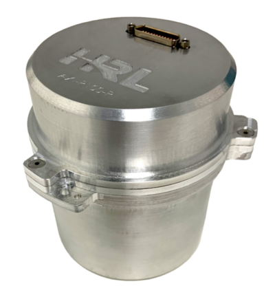
    HRL Laboratories has introduced a new inertial measurement unit (IMU) that provides near navigation-grade accuracy in a palm-sized package.

    Smaller and lighter than grade-equivalent conventional sensors, HRL’s AXI-R100 delivers range-extending accuracy for GPS-contested navigation. The product is now ready for pre-production orders.

    Using silicon microelectro-mechanical systems (MEMS) technology, HRL’s gyros exceeds the performance of many tactical-grade IMUs in the same or smaller package size, and is manufactured in high volumes at wafer-scale. This near navigation-grade performance is available at a tactical-grade price.

    The new IMU is suitable for use in defense, aerospace and automotive applications, including missile-guidance systems and drone navigation, as well as for commercial automotive applications with higher levels of autonomy. The product is ready for integration as it has been designed and tested against challenging vibration, shock and thermal conditions representative of those applications.

    HRL will present product specifications at the 2026 Joint Navigation Conference, taking place this week in Cincinnati, Ohio, and is exhibiting in booth 129.

      By leveraging high volume design automotive methodologies, HRL designed AXI-R100 navigation sensors to scale for high-volume automotive demand while maintaining performance superiority over traditional tactical-grade sensors. The result is a gyroscope compatible with foundry fabrication processes for high volume applications.

      “Our gyroscopes and inertial sensors support navigation, pointing and stabilization systems for autonomous vehicles, aircraft and guided missile and munition applications,” said Jeff Dickman, director, Precision Sensing, HRL Laboratories. “We leveraged our extensive microelectronics legacy along with innovations in micromechanical and manufacturing processes to pave the way for AXI-R100 to address the urgent needs from our industrial base.”

    • Rohde & Schwarz to highlight UAV-based navigation analyzer at IFIS 2026

      Rohde & Schwarz to highlight UAV-based navigation analyzer at IFIS 2026

      The 23rd International Flight Inspection Symposium (IFIS) will gather experts in San Salvador May 4-8. There, Rohde & Schwarz will demonstrate its test and measurement solutions for ground-based navigation aids. The exhibits address the rising traffic volumes and stricter safety requirements.

      Rohde & Schwarz will take part in the conference’s technical sessions with a presentation on “Challenges for UAV Operations in RF Dense Aerodrome Environments.”

      The aviation sector today faces increasing air traffic density, rapid technological advancements and heightened security concerns, the company explained. Operators need test equipment that delivers laboratory level precision while tolerating the harsh environment of an airport runway or a remote navigation site.

      Among the exhibits at the Rohde & Schwarz booth is the R&S EVSD1000 VHF/UHF Nav/Drone Analyzer, designed to conduct GBAS, ILS and VOR measurements in line with ICAO Doc 8071 and ICAO Annex 10. The receiver delivers laboratory precision, supports an air to ground Wi‑Fi datalink and gapless measurements with improved location accuracy during flight inspections. Customers benefit from a device that can be mounted on a drone, reducing the need for manned flights and lowering operational expenses.

      Rohde & Schwarz gives airlines, airport operators and navigation service providers a reliable way to certify and maintain ground‑based aids under today’s demanding conditions. By combining high measurement accuracy, easy operation and durability, Rohde & Schwarz aims to help the industry keep pace with growth.

    • FAA updates GNSS Interference Resource Guide

      FAA updates GNSS Interference Resource Guide

      The U.S. Federal Aviation Administration (FAA) has updated its GNSS Interference Resource Guide with updated information on GNSS vulnerabilities and general edits throughout.

      The FAA’s Flight Technologies and Procedures Division (AFS-400) developed the guide to provide U.S. operators and pilots with the most current information regarding GPS and GNSS jamming and spoofing.

      According to the guide’s introduction, “The impacts of safety hazards from GNSS interference rapidly spread over the past few years and is persistent. As the threat of GNSS jamming and spoofing is constantly changing, the FAA will update this resource guide to provide the best guidance in the rapidly changing environments.”

      Download the guide here.

    • Viavi launches ePRTC360+ clock alternative to Cesium-accuracy holdover clock

      Viavi launches ePRTC360+ clock alternative to Cesium-accuracy holdover clock

       Viavi Solutions Inc. has launched the patent-pending Cesium-less ePRTC360+ holdover solution to safeguard at-risk critical power grids, transportation, aviation and public safety systems, 5G mobile networks and AI data center infrastructure against the increased threat of GNSS timing disruptions. It is the only alternative to Cesium clocks to meet ITU-T G.8272.1 standards.

      The international ITU-T G.8272.1 standard stipulates that Enhanced Primary Reference Time Clock (ePRTC) holdover must have short-term drift of less than 30 ns when entering into holdover and a long-term drift of less than 100 ns over 14 days, all traceable to UTC. Previously achieved only by Cesium atomic clocks, VIAVI’s ePRTC360+ now also meets this standard.

      ePRTC360+ Enhanced Primary Reference Time Clock

      The ePRTC360+ has been successfully tested across a range of live-sky defense and commercial jamming/spoofing environments, and has been integrated into VIAVI’s SecurePNT 6200 product series. The technology can maintain 100 ns accuracy during GNSS-denied threats through the resilient altGNSS GEO-L service with no time limit.

      It also combines an augmented VIAVI SecureTime GEO anti-jamming antenna and an enhanced GNSS anti-spoofing antenna that also receive eGNSS GEO service with GPS/GNSS-NMA authentication for spoofing detection and mitigation.

      Unlike conventional GNSS omni-directional signals, which can be drowned out by low-power interference, VIAVI’s GNSS-independent GEO-L service leverages encrypted and highly directional L-band signals transmitted from geostationary satellites. Coupled with the augmented VIAVI SecureTime GEO antenna, the altGNSS GEO-L service provides enhanced anti-jamming protection and a resilient timing reference for the ePRTC360+’s internal Rubidium holdover oscillator and enables smooth multi-orbit source switchover, even when primary GNSS frequencies are jammed, spoofed or subject to sophisticated meaconing attacks.

      The affordability of ePRTC360+ clocks compared to Cesium clocks enable operators to deploy them beyond the core and across the network. They also complement non-RF Cesium clocks at the core. This boosts end-to-end sync network robustness and holdover reliability through meshed network PTP feeds as backup between the clocks, especially in case of local or regional jamming and/or spoofing threats.

      In addition, the ePRTC360+ addresses constraints posed by the use of Cesium clocks for holdover timing. These include sensitivity to shock, delicate and multi-stage startup procedures that take days to complete, the need for ECCN 3A001.i licenses for export, long GNSS learning period of up to 40 days, as well as strict shipping and storage protocols. In addition, Cesium tubes need to be replaced approximately every seven years, and the dismantling and disposal of Cesium clocks are classified as a hazard due to their material content.

      The ePRTC360+ eliminates these hurdles and has been designed for rapid and easy integration into any vendor’s grandmaster clock system. It enables operators to meet stringent ePRTC requirements while reducing total cost of ownership.

      The ePRTC360+ will be demonstrated at VIAVI’s Stand 5B18 at Mobile World Congress (MWC) Barcelona 2026, March 2-5, in Barcelona, Spain. 

    • GPS World  EAB: The most promising approaches for limiting jamming in aviation

      GPS World EAB: The most promising approaches for limiting jamming in aviation

      In the Jan.-Feb. 2026 edition of GPS World magazine, we asked our experts, with the increase in reported GNSS jamming incidents affecting commercial aviation, what technical approaches show the most promise for ensuring reliable PNT?

      Check out their responses below:

      Photo: Mitch Narins headshot
      Mitch Narins

      Mitch Narins, Strategic Synergies

      “Aviation encompasses a diverse range of applications and missions, requiring support from various positioning, navigation and timing (PNT) solutions. As with most challenges, employing multiple strategies often yields optimal outcomes, particularly in scenarios where a one-size-fits-all approach is impractical. I firmly believe in the enduring importance of the guidance historically imparted to navigators: to ‘utilize all available means.’

      However, it is crucial to recognize that GNSS jamming is not the primary concern. Fortunately, aviation has historically and continues to rely on resilient ground-based alternatives, although many of these systems have been in service for several decades and require upgrades and replacements. The more pressing issue for aviation and other PNT applications lies in spoofing. I strongly advocate for the abandonment of the concept of employing a single, non-resilient solution for critical functions, a practice once referred to as ‘GPS sole-means.’”

      Miguel Armor
      Miguel Armor

      Miguel Amor, Septentrio

      “Ensuring reliable navigation and timing in the presence of increasing GNSS jamming requires both stronger technology and faster modernization in aviation. Today, the most effective protection is a layered approach, starting with advanced interference mitigation at the receiver level. Modern anti-jamming algorithms and robust signal processing, combined with multi-frequency and multi-constellation capabilities, provide important diversity and allow systems to continue operating even in difficult RF environments. CRPA antennas also further improve resilience by enabling spatial filtering and adaptive nulling, suppressing jammers before they impact the receiver.”

      Paul McBurney
      Paul McBurney

      Paul McBurney, oneNav

      “Controlled Reception Pattern Antennas (CRPAs) and adoption of L5. As discussed by Brad Parkinson, Ph.D., at the most recent National Space-based PNT Advisory Board (PNTAB) meeting, the CRPA is the big-hammer anti-jam solution. It’s great to hear that the ITAR restrictions have been removed. For commercial aviation, the long pole to deployment is likely dependent on an FAA certification procedure. The other advice from PNTAB is that L5 has a much smaller denial radius. So, once again, the U.S. Government and FAA are on the critical path: We need L5 to be declared healthy and usable, which likely requires an upgrade of RTCA MOPS.”

    • FAA warns pilots of risks in flying over Venezuela

      FAA warns pilots of risks in flying over Venezuela

      The U.S. Federal Aviation Administration (FAA) has warned all pilots to “exercise caution” when flying in the airspace over Venezuela “due to the worsening security situation and heightened military activity,” reports ABC News. Possible risks include GNSS jamming and spoofing.

      The FAA message said the unspecified threats “could pose a potential risk to aircraft at all altitudes” as well planes taking off and landing in the country and even aircraft on the ground.

      The warning comes as the Trump administration has ramped up pressure on Venezuelan President Nicolás Maduro. The Trump administration also has carried out a series of strikes on small boats in the Caribbean Sea and eastern Pacific Ocean that it accuses of ferrying drugs to the U.S., killing more than 80 people since the campaign began in early September.

      The U.S. military has conducted bomber flights up to the coast of Venezuela, sometimes as part of a training exercise to simulate an attack, and sent the aircraft carrier USS Gerald R. Ford into the region.

      The Ford aircraft carrier and several destroyers were just the latest addition to the largest U.S. force assembled in the Caribbean Sea near Venezuela in generations. The Trump administration does not see Maduro, who faces charges of narcoterrorism in the U.S., as the legitimate leader of the South American country.

    • Qatar hosts regional workshop on GNSS interference

      Qatar hosts regional workshop on GNSS interference

      The Qatar Civil Aviation Authority (QCAA) this week is hosting the Joint ICAO Europe and North Atlantic (EUR/NAT) and Middle East (MID) Workshop on GNSS Radio Frequency Interference, reports the Qatar News Agency.

      The workshop is organized jointly by the ICAO EUR/NAT and MID Regional Offices and is being held in Doha, Qatar, Nov.18-20.

      In the opening session, Mohamed bin Faleh Al Hajri, QCAA manager, reaffirmed Qatar’s commitment to enhancing aviation safety and efficiency through close collaboration with ICAO and regional partners.

      The workshop brings together countries and stakeholders from the EUR/NAT and MID regions to address the increasing threat that GNSS radio frequency interference poses to aviation safety and efficiency. Al Hajri emphasized the importance of active participation to exchange experiences, strengthen cooperation, and build sustainable partnerships that support GNSS resilience.

      He highlighted that hosting the workshop reflects joint efforts aimed at strengthening the robustness and reliability of GNSS — a core pillar in ensuring the safety and efficiency of international air navigation.

      Regional dialogue

      The workshop aims to:

      • facilitate regional dialogue on the operational impact of GNSS radio frequency interference
      • share experiences among participating States and stakeholders
      • explore measures to improve reporting mechanisms, enhance mitigation strategies, and strengthen the overall resilience of satellite-based navigation systems.

      It also seeks to reinforce cooperation between the EUR/NAT and MID Regions to safeguard the infrastructure and integrity of GNSS-based navigation systems.

    • Kolkata is latest Indian city to be affected by GNSS interference

      Kolkata is latest Indian city to be affected by GNSS interference

      India has issued a Notice to Air Missions (NOTAM) warning of possible GPS interference or signal loss along air traffic routes near Kolkata, reports Business Today.

      The NOTAM, valid Nov. 13-17, alerts airlines and pilots to remain vigilant to GNSS disruptions. It follows previous communications sharing issues with GNSS interference in New Delhi and Mumbai. Pilots and air traffic controllers also were asked to report any interference incidents within 10 minutes to the Directorate General of Civil Aviation (DGCA).

    • Pilots, ATC asked to report GPS interference in India within 10 minutes

      Pilots, ATC asked to report GPS interference in India within 10 minutes

      India’s Directorate General of Civil Aviation (DGCA) has made it mandatory for pilots and air traffic controllers to report GPS interference within 10 minutes of it occurring, reports Hindustan Times. The new protocol follows incidents at the New Delhi airport reported on Nov. 5.

      Incidents that should be reported include position anomalies, navigation errors, loss of GPS integrity, and spoofed location data, states a three-page circular issued on Nov. 10.

      The real-time reporting should include data such as aircraft type and registration, airline or operator name, date and time of spoofing occurrence, flight sector and route, coordinates or area of occurrence, type of interference and aircraft equipment affected.

    • India increases efforts to collect GNSS spoofing data

      India increases efforts to collect GNSS spoofing data

      India’s aviation regulator, the Directorate General of Civil Aviation (DGCA), is collecting data on GPS interference and spoofing to have a better understanding of the situation, reports several news outlets in the country. The urge to collect data comes after the Delhi airport experienced issues in the past few days.

      Following a circular issued by the Directorate General of Civil Aviation in 2023, instances of GPS interference/spoofing have been reported since November 2023.

      Recently, several airlines have faced GPS spoofing at the New Delhi airport, with at least eight such instances on Nov. 5, said an unnamed DGCA official. The interference instances were noticed in domestic and international flights.

      Generally, interference issues are reported in border areas, rather than at Indira Gandhi International Airport, the country’s busiest. Daily flight movements have increased to more than 1,500 following an airport terminal upgrade completed in October.

      As many as 465 GPS interference and spoofing incidents were reported in the border region, mostly in the Amritsar and Jammu areas, between November 2023 and February 2025.

    • EASA, IATA release 4-point plan to mitigate GNSS interference risks

      EASA, IATA release 4-point plan to mitigate GNSS interference risks

      The International Air Transport Association (IATA) and the European Union Aviation Safety Agency (EASA) have published a comprehensive plan to mitigate the risks stemming from GNSS interference. The plan was among the conclusions of a jointly hosted workshop on the topic of GNSS interference.

      Given the continued rise in frequency of interference with GNSS signals, the workshop concluded that a broader and more coordinated approach is needed. focusing on four key areas: improved information gathering, stronger prevention and mitigation measures, more effective use of infrastructure and airspace management, and enhanced coordination and preparedness among relevant agencies.

      Reported incidents of interference with GNSS signals have been increasing across Eastern Europe and the Middle East in recent years. Similar incidents have been reported in other locations globally. The initial response focused only on containing those GNSS interference incidents.

      “GNSS disruptions are evolving in terms of both frequency and complexity,” said Jesper Rasmussen, EASA Flight Standards director. “We are no longer just containing GNSS interference — we must build resilience. The evolving nature of the threat demands a dynamic and ambitious action plan. Through collaboration with partners in the European Union and IATA, and by supporting the International Civil Aviation Organization (ICAO), we are committed to keeping aviation safe, secure and navigable.”

      The number of GPS signal loss events increased by 220% between 2021 and 2024, according to IATA’s data from the Global Aviation Data Management Flight Data eXchange (GADM FDX). “With continued geopolitical tensions, it is difficult to see this trend reversing in the near term,” said Nick Careen, IATA senior vice president, Operations, Safety and Security. “IATA and EASA are working together to reinforce the redundancies that are built into the system, to keep flying safe. The next step is for ICAO to move these solutions forward with global alignment on standards, guidance and reporting. This must command a high priority at the ICAO Assembly later this year. To stay ahead of the threat, aviation must act together and without delay.”

      Detailed Workshop Outcomes

      The workshop concluded that four workstreams are critical.

      1. Enhanced Reporting and Monitoring

      • Agree on standard radio calls for reporting GNSS interference and standardized notice to airmen (NOTAM) coding, i.e. Q codes.
      • Define and implement monitoring and warning procedures, including real-time airspace monitoring.
      • Ensure dissemination of information without delays to relevant parties for formal reporting.

      2. Prevention and Mitigation

      • Tighten controls (including export and licensing restrictions) on jamming devices.
      • Support the development of technical solutions to:
        • reduce false terrain warnings;
        • improve situational interference with portable spoofing detectors; and
        • ensure rapid and reliable GPS equipment recovery after signal loss or interference.

      3. Infrastructure and Airspace Management

      • Maintain a backup for GNSS with a minimum operational network of traditional navigation aids.
      • Better utilize military air traffic management (ATM) capabilities, including tactical air navigation networks and real-time airspace GNSS incident monitoring.
      • Enhance procedures for airspace contingency and reversion planning so aircraft can navigate safely even if interference occurs.

      4. Coordination and Preparedness

      • Improve civil-military coordination, including the sharing of GNSS radio frequency interference (RFI) event data.
      • Prepare for evolving-threat capabilities, also for drones.

      The workshop was held at EASA’s headquarters in Cologne, Germany, on May 22-23, and was attended by more than 120 experts from the aviation industry, research organizations, government bodies and international organizations.

    • CMC Electronics and ÉTS launch major research chair in resilient aviation navigation

      CMC Electronics and ÉTS launch major research chair in resilient aviation navigation

      A five-year research and development program has been launched to enhance GNSS navigation for aviation, encompassing security, integrity and spoofing resilience.

      CMC Electronics is partnerinng with École de Technologie Supérieure (ÉTS) in Quebec, Canada, to create the CMC Electronics Industrial Research Chair in Resilient GNSS Navigation. The five-year chair, valued at more than $6 million, unites CMC’s avionics expertise, led by John Studenny, internationally recognized GNSS navigation expert and standards contributor, with ÉTS’s renowned LASSENA laboratory under René Jr. Landry, an expert in aerospace navigation and cybersecurity.

      The chair will tackle critical threats to GNSS navigation for aviation, including jamming and spoofing. CMC and ETS aim to develop spoofing-resilient GNSS receivers capable of real-time detection, mitigation and total recovery from spoofing attacks, setting a benchmark in aviation safety and integrity.

      Research focus areas

      The chair’s work spans several integrated areas that target key GNSS security challenges:

      • integration of spoofing detection algorithms
      • spoofing resilience grading and stress testing frameworks
      • recovery mechanisms and certification benchmarking
      • advanced integrity algorithms (ARAIM)
      • sensor fusion and authentication technologies for spoofing mitigation
      • end-to-end spoofing-resilient GNSS prototype
      • next-generation inertial sensors with built-in integrity

      Together, these areas aim to produce operational, spoofing-resilient GNSS systems suitable for aviation environments.

      Broader impact and strategic alignment

      The chair will train more than 65 highly qualified personnel (HQPs) and promote equity, diversity and inclusion in engineering. It supports initiatives to increase women’s representation and aligns with ÉTS’s strategic research fields in aerospace, cybersecurity, sensors and intelligent autonomous systems.

      CMC Electronics is co-leading the research program and industrial deployment, ensuring that the outcomes are fast-tracked toward secure, export-ready GNSS solutions. Safran Trusted 4D contributes specialized expertise, and Jaunt Air Mobility provides operational insights for flight testing and system integration.