Tag: aviation

  • Blue Sky Network Debuts Mobile Tracker with Geofencing

    Blue Sky Network Debuts Mobile Tracker with Geofencing

    Blue Sky Network's HawkEye 7200 Portable  Tracking Solution.
    Blue Sky Network’s HawkEye 7200 Portable Tracking Solution.

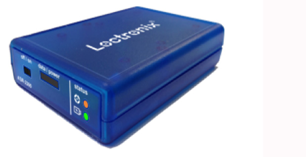
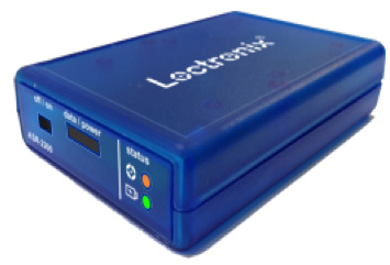
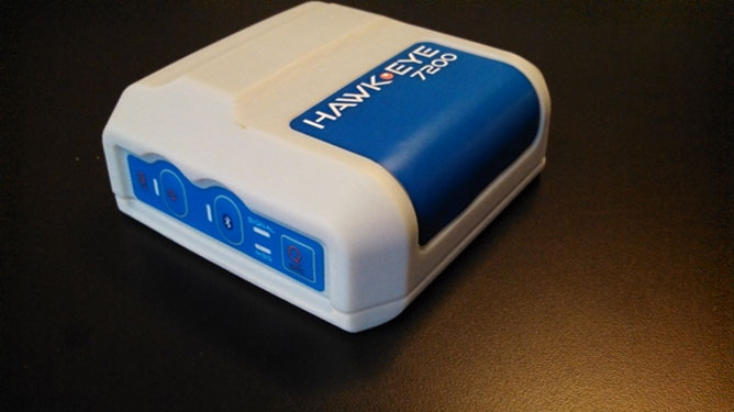
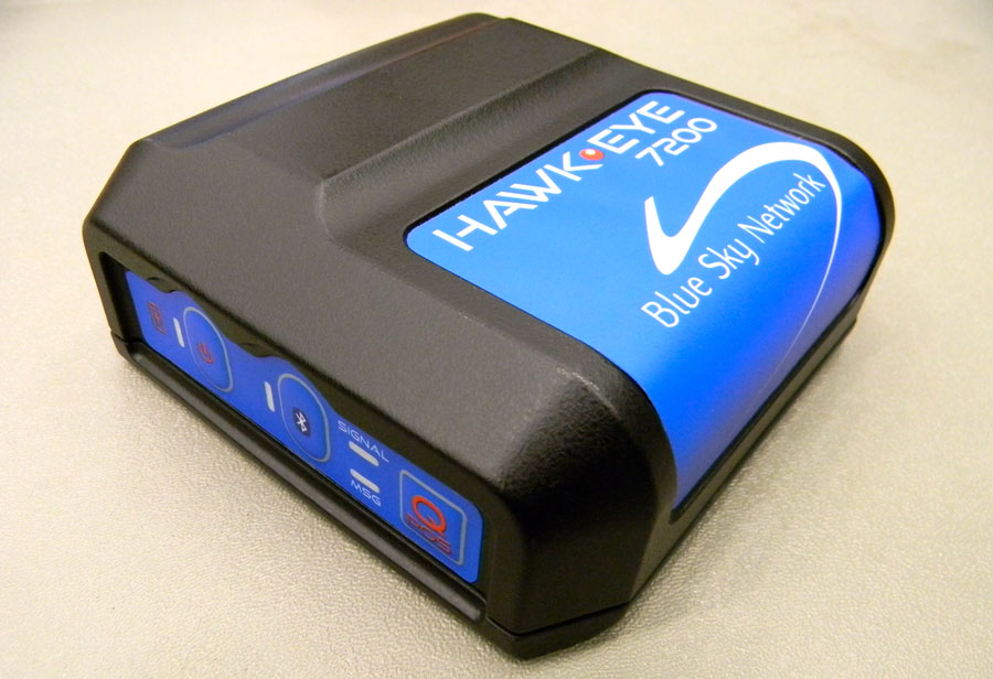
    Blue Sky Network has released the portable HawkEye 7200 with geofencing. The Hawkeye 7200, released in September 2013, is a small mobile device designed specifically for Iridium and GNSS satellite tracking of aviation, land/mobile or marine assets. The company will demonstrate its new AVR (advanced variable response) geofencing capabilities at the upcoming HAI Heli-Expo tradeshow in Anaheim, California, February 25-26.

    “Advanced variable response or AVR delivers functionality and utility one level beyond traditional geofencing alarms or alerts. It allows the asset manager or geofence designer to set a conditional response for what happens or does not happen when an aircraft, vehicle, or vessel is in, or out of a geofenced area,” explains John Peterson, Blue Sky Network’s vice president of Business Development. “For example, position reporting frequencies could be turned off when an asset is at its home base, resume normal reporting after leaving the base, and increase reporting frequency when entering regions considered more dangerous. AVR gives asset managers more control, ultimately making fleet management easier, safer, and less expensive.”

    In addition to AVR, the HawkEye 7200 offers three significant advantages over traditional satcom asset tracking devices

    • An all-in-one design including internal long-lasting lithium ion battery and dual Iridium and GNSS antenna;
    • true concurrent multi-national GNSS for faster, more accurate positioning; and
    • Bluetooth connectivity using Blue Sky Network’s custom APP for iPhone and iPad, facilitating easy messaging and custom form transmission from Apple devices.

    The HawkEye 7200 portable satcom solution works directly with Blue Sky Network’s cloud-based web portal SkyRouter. Skyrouter is a secure online website that provides tracking and management of globally dispersed assets.

  • Jackson Labs Delivers Low Phase-Noise Frequency and Timing Reference

    Jackson Labs Delivers Low Phase-Noise Frequency and Timing Reference

    The DROR-II by Jackson Labs.
    The DROR-II by Jackson Labs.

    Jackson Labs Technologies, Inc., a designer and manufacturer of GPS, timing and frequency equipment, is offering the DROR-II, a 10-MHz/5-MHz/1-PPS GPS-Disciplined Atomic Frequency and Timing Reference (GPSDO).

    The DROR-II is a ruggedized frequency and timing reference with a Cesium Vapor Atomic Oscillator followed by a precision SC-cut Crystal Double-Oven Oscillator and an actively vibration-compensated VCXO oscillator, with specific emphasis on ultra low phase noise performance under extreme vibration and acceleration such as could be encountered in aircraft, tracked vehicles, and wheeled vehicles.

    The DROR-II unit is optimized for operation in high-vibration and high-acceleration environments that require ultra-low phase noise performance and high frequency stability under extreme conditions. The DROR-II combines the strengths of three different on-board oscillators to provide an overall performance that has not been achievable with legacy products, at a steady-state power consumption of less than 3.85W, the company said.

    The DROR-II uses a GPS receiver to provide long-term phase and frequency accuracy of the built-in CSAC atomic oscillator which is followed by an SC-cut, Double Oven OCXO (DOCXO) for very high short-term stability and low phase noise, which is itself followed by a three-axis electronically vibration-compensated crystal oscillator for ultra-low-noise under high vibration. Using these four signal sources cascaded to each other allows unmatched Phase Noise and Short Term Stability (ADEV) while also providing long-term atomic holdover, very fast warmup, and long-term phase-lock to UTC. Short term stability of 1E-012 (1ppt), and phase noise floors of -162dBc/Hz are achieved. Frequency stability over 24 hours is better than 5E-013 (0.5ppt) typically when locked to GPS.

    The DROR-II supplies three isolated 10-MHz Sine Wave outputs, two CMOS 1PPS, and one 5-MHz output that is phase-synchronized to UTC via the internal GPS receiver. DROR-II contains a 50-channel WAAS/EGNOS/MSAS-enabled GPS receiver that provides support for avionics systems through integrated three-axis gyro-accelerometers and a -160-dBm GPS tracking capability. DROR-II power requirements are less than 3.85W steady-state, and only a single supply of between 11.0V to 32V is required. Support for an external LCD display is standard.

    The unit can be monitored and controlled by an RS-232 port or a USB port via industry standard SCPI-99 Commands (GPIB commands), and is capable of generating numerous NMEA-0183 output sentences for easy integration into existing infrastructure. The DROR-II can be ordered with various OCXO options and with different temperature ranges.

  • GAGAN Certified for Aviation in India

    The Director General of Civil Aviation (DGCA) of India certified on December 30 the GAGAN system to RNP0.1 (Required Navigation Performance 0.1 Nautical Mile) service level, according to The Hindu.

    Now aircraft equipped with Satellite Based Augmentation System (SBAS) receivers will be able to use GPS-Aided Geo Augmented Navigation (GAGAN) signals in Indian airspace for en route navigation and non-precision approaches without vertical guidance.

    Mission control centers, along with associated uplink stations, have been set up at Kundalahalli in Bangalore. Another control center and uplink station are in Delhi. A top official of the AAI said one of the Reference Stations has been housed outside the premises of the Thiruvananthapuram airport. The reference stations pick up signals from the orbiting GPS satellites. The measurements are immediately passed on to the mission control centers that then work out the necessary corrections that must be made. Messages carrying those corrections are sent via the uplink stations to the satellites in geostationary orbit that have the GAGAN payload.

    The availability of the GAGAN signal in the country’s air space will bridge the gap between European Union’s European Geostationary Navigation Overlay Service (EGNOS) and Japan’s Multi-functional Satellite Augmentation System (MSAS) coverage areas.

    The SBAS consists of 15 Indian Reference Stations, three Indian Navigation Land Uplink Stations, three Mission Control Centers, three Geo-Stationary Navigation Payload in C and L bands and with all the associated software and communication links.

    GAGAN will provide augmentation service for GPS over India, the Bay of Bengal, South East Asia and the Middle East expanding up to Africa.

  • Galileo Achieves First Airborne Tracking

    Galileo Achieves First Airborne Tracking

    Aircraft position as obtained by Galileo-only receiver during Netherlands flight.
    Aircraft position as obtained by Galileo-only receiver during Netherlands flight.

    The European Space Agency’s Galileo satellites have achieved their first aerial fix of longitude, latitude and altitude, enabling the inflight tracking of a test aircraft. ESA’s four Galileo satellites in orbit have supported months of positioning tests on the ground across Europe since the first fix in March.

    Now the first aerial tracking using Galileo has taken place, marking the first time that Europe has been able to determine the position of an aircraft using only its own independent navigation system. The milestone took place on a Fairchild Metro-II above Gilze-Rijen Air Force Base in the Netherlands at 12:38 GMT on November 12. It was part of an aerial campaign overseen jointly by ESA and the National Aerospace Laboratory of the Netherlands, NLR, with the support of Eurocontrol, the European Organisation for the Safety of Air Navigation, and LVNL, the Dutch Air Navigation Service Provider.

    A pair of Galileo test receivers was used aboard the aircraft, the same kind employed for Galileo testing in the field and in labs across Europe. They were connected to an aeronautical-certified triple-frequency Galileo-ready antenna mounted on top of the aircraft.

    Fairchild Metro-II aircraft used for Galileo airborne testing.
    Fairchild Metro-II aircraft used for Galileo airborne testing.

    Tests were scheduled during periods when all four Galileo satellites were visible in the sky – four being the minimum needed for positioning fixes. The receivers fixed the plane’s position and, as well as determining key variables such as the position, velocity and timing accuracy; time to first fix; signal-to-noise ratio; range error; and range–rate error.

    Testing covered both Galileo’s publicly available Open Service and the more precise, encrypted Public Regulated Service, whose availability is limited to governmental entities.

    Flights covered all major phases: take off, straight and level flight with constant speed, orbit, straight and level flight with alternating speeds, turns with a maximum bank angle of 60º, pull-ups and push-overs, approaches and landings.

    They also allowed positioning to be carried out during a wide variety of conditions, such as vibrations, speeds up to 456 km/h, accelerations up to 2 ghorizontal and 0.5–1.5 gvertical, and rapid jerks. The maximum altitude reached during the flights were 3000 m.

    NLR’s Fairchild Metro-II has previously performed initial European GPS testing in the 1980s, and the first tests of the European Geostationary Navigation Overlay Service, EGNOS, which sharpens GPS accuracy and monitors its reliability over Europe for high-accuracy or even safety-of-life uses.

    The definition and development of Galileo’s in-orbit validation phase were carried out by ESA and co-funded by ESA and the EU.

    The Full Operational Capability phase is managed and fully funded by the European Commission. The Commission and ESA have signed a delegation agreement by which ESA acts as design and procurement agent on behalf of the Commission.

  • Loctronix Ships ASR-2300 Software-Defined Radio Module for Indoor/Outdoor Positioning

    Loctronix Ships ASR-2300 Software-Defined Radio Module for Indoor/Outdoor Positioning

    Loctronix ASR2300 module.
    Loctronix ASR-2300 module.

    Loctronix Corporation, a provider of unified positioning solutions for GNSS-challenged environments, announced that it has begun shipments of its new software-defined radio (SDR) module, the ASR-2300, for developing high-performance positioning, navigation and timing (PNT), and communication applications.

    “The ASR-2300 delivers advanced SDR capabilities in a small, mobile form-factor enabling developers to readily create and field complex SDR-based solutions. Featuring a 2×2 multiple-input, multiple-output (MIMO) RF transceiver and an array of inertial sensors, the open-source ASR-2300 is an ideal platform for tapping advanced, multi-sensor/signals of opportunity for high-performance PNT,” said Michael Mathews, Loctronix’ CEO and founder.

    Loctronix ASR-2300 kit.
    Loctronix ASR-2300 kit.

    “Unique amongst the growing number of SDRs, Loctronix’ ASR-2300 provides multiple, fully-integrated RF paths supporting reception of GNSS, cellular, ISM band, and UHF signals of opportunity, making it well-suited for demanding scientific, military, aerospace and commercial/industrial applications, such as UAV/UAS navigation, GPS-challenged or -denied tracking and navigation, combined communications and navigation radios, and GPS integrity monitoring and validation,” Mathews noted.

    The MIMO transceiver module incorporates two wideband Field Programmable RF (FPRF) transceivers (300 MHz to 3.8 GHz), 10-axis accelerometer/gyro/compass/barometer sensors, and a large programmable FPGA capable of over 300 MiB/sec sustained communications with a host processor via USB 3.0 interface.  The module’s nine integrated RF path options and low size, weight, and power characteristics contribute to ease of integration and portability, Loctronix said.  Accommodating both internal 1 PPM TCXO or external frequency reference, multiple ASR-2300s can be inter-connected via an expansion port and/or UART interface, supporting real-time reception / transmission of 4, 6, 8 or more signals without the need for significant additional hardware.

    Developers looking to create solutions for demanding military, scientific and industrial applications will realize greater functionality with the ASR-2300, thanks to its multiple sensor and multiple frequency capabilities, Loctronix said. Additionally, access to a variety of user-friendly development tools facilitates waveform experimentation and helps speed the creation of these new solutions, resulting in shorter development times and lower development costs for high-performance PNT applications.

    Bundled kits, which include the module, housing, and power/data communications/RF interfaces, are priced at $1,600 with a special educational discount available for qualified institutions.  The ASR-2300 SDR is available directly from Loctronix.

  • Navtech Partners with DW International on GNSS Coverage for Flight Planning

    Navtech, Inc., a Toronto-based provider of flight operations services, has entered a partnership with DW International (DWI). The UK-based aviation consultancy will provide Navtech Flight Plan (NFP) customers with GNSS RAIM/RNP Prediction Services. This service, required to meet FAA Performance Based Navigation (PBN) guidelines and state requirements, fits into Navtech’s current suite and provides GPS coverage information for routes and airports as part of the flight planning process.

    Navtech serves more than 350 airlines and aviation services customers. Its product suite includes aeronautical charts, navigation data solutions, flight planning, aircraft performance software (take-off/landing, weight and balance), and crew planning solutions.  Many of Navtech’s products can be configured as part of an EFB solution, including take-off data calculation, weight and balance, and aeronautical charts.

    DWI is an independent consultancy which provides technical support in the fields of air navigation, civil air communications and air traffic management. The company also develops and maintains bespoke (custom) software and manages websites that support air operations. The company has access to a wide range of experienced technical experts including airworthiness and operational approvals inspectors, aviation safety engineers and air traffic management consultants.

    “The relationship with DWI will strengthen the Navtech Flight Plan product,” said Bill Macey, Product Director, Flight Planning at Navtech. “We are continuously motivated to provide our customers with superior quality offerings, especially when they are supported by a partnership with a reputable aviation firm like DWI. Their reliable 24/7 service along with their initial help desk support will afford our users peace of mind.”

    The GRPS service allows operators to comply with all FAA, European, ICAO and other worldwide RAIM requirements and guidelines. Specifically, real-time tailored RAIM predictions for RNAV and RNP operations are delivered through NFP via the internet to NFP users.

    The service is fully automated for dispatchers/flight planners to obtain their predictions as they plan their route and the service allows dispatchers/flight planners and crew to plan around periods of reduced GNSS availability by taking all route details from the flight plan and calculating RAIM availability for all route types (such as enroute, terminal, approach) on a leg-by-leg basis. Destination and alternate airports for RNAV and RNP around the world are included. GRPS also processes GPS NANUs, evaluating and interpreting them in view of establishing their relevance to the RAIM availability.

    “DWI is pleased to be working with Navtech to provide their customers with the RAIM predictions they need for GNSS-based operations,” said John Wilde, CEO of DWI. “The consistency and availability of our service provides the reliability NFP users require.”

  • Northrop Grumman Offers Open Architecture Solutions for Enhanced Avionics Capabilities

    Northrop Grumman Offers Open Architecture Solutions for Enhanced Avionics Capabilities

    Logo: FACENorthrop Grumman Corporation is applying a modular, open architecture approach throughout its product portfolio, allowing for rapid addition of new avionics capabilities for warfighters. Northrop Grumman is already applying the FACE Reference Architecture and interfaces to existing programs and products, including an embedded GPS/inertial navigation system for the Joint Precision Approach and Landing System and a highly adaptable mission equipment package.

    As a founding principal member of The Open Group Future Airborne Capability Environment (FACE) Consortium, Northrop Grumman was an early advocate of establishing open architecture standards to support software portability and interoperability across avionics systems.

    Northrop Grumman will leverage the corporation’s expertise in open architecture to implement FACE requirements for both current and future programs, including the Black Hawk H-60L Digital Performance Plan program and Tech-Refresh Mission Computers for the H-1 Upgrade program.

    The company plans to participate in demonstrations that will promote maturation of the FACE Reference Architecture by enabling companies to deploy their products in a functional, standardized FACE software environment.

    Also, the company’s Transport Services Segment aligns with the FACE Technical Standard requirements and provides a standard interface that allows portable avionics applications to be integrated with a variety of architectures and aviation platforms.

    “An open architecture approach is critical to the affordability, innovation and effectiveness of avionics systems,” said Ike Song, vice president of Northrop Grumman’s Situational Awareness Systems business unit. “We are using performance-proven solutions from across our corporation to offer highly flexible, affordable products that support reuse on various platforms.”

    Northrop Grumman’s Common Mission Management System (CMMS) establishes a common foundation for affordable control systems to support a variety of the company’s unmanned products. Based upon open architecture standards and standard off-the-shelf commercial hardware and software infrastructures, the Northrop Grumman CMMS product line avoids the need for dedicated, custom-built command and control systems for individual platforms. Also, the Northrop Grumman CMMS product line enables pilots to operate a variety of dissimilar unmanned platforms using the same informational displays and control features, thereby improving mission effectiveness while reducing training requirements.

    With its expertise in unmanned aerial systems (UAS), the Northrop Grumman team was instrumental in leading the FACE Consortium’s effort to align with the UAS Control Segment (UCS) information model, establishing a common conceptual data model and metamodel as a framework that defines rules and conventions for developing interoperable software components for unmanned aerial system ground control stations. Further collaboration under the UCS/FACE Memorandum of Agreement is anticipated in aligning the FACE and UCS standards.

    Northrop Grumman is a leading global security company providing innovative systems, products and solutions in unmanned systems, cyber, C4ISR, and logistics and modernization to government and commercial customers worldwide.

  • Applanix Adds High-Performance POS Systems to Air and Land Portfolios

    Applanix Adds High-Performance POS Systems to Air and Land Portfolios

    Photo: Applanix
    Photo: Applanix

    Applanix, a mobile mapping and positioning company, has introduced new versions of its positioning and orientation systems for airborne and land-based mapping — the POS AV 610 and POS LV 610.  Delivering the same industry-leading performance as previous versions of POS AV and LV, the new systems use next-generation commercial inertial technologies that are offered globally.

    Applanix POS AV and LV products integrate precision GNSS with advanced inertial technology (accelerometers and gyroscopes) to provide uninterrupted measurements of the position, roll, pitch and true heading of moving vehicles.  Geospatial projects using POS can be completed more efficiently, effectively and economically. The POS AV 610 and POS LV 610 offer new advantages to customers:

    • Global availability: commercial technology.
    • Smaller and lighter: achieved by integrating a new state-of-the-art FOG (Fiber Optic Gyro) based Inertial Measurement Unit (IMU).
    • Exceptional performance with Applanix SmartCalTM software:  SmartCal is a new compensation technology designed to achieve unrivalled performance from IMUs manufactured specifically for mobile mapping applications.
    • Cost efficiency: exceptional accuracy, even in demanding conditions, at unprecedented price points.

    POS LV 610 and AV 610 are also available to systems integrators in the form of an OEM board set called the Trimble AP60. The Trimble AP is a series of embedded GNSS-Inertial OEM boards that provide both continuous mobile positioning in poor signal environments and high-accuracy direct georeferencing of imaging sensors.  The AP series is ideal for a variety of commercial mobile positioning and orientation applications including airborne and terrestrial mapping and guidance for unmanned vehicles.

    “The latest versions of POS LV and POS AV take Applanix’ state-of-the-art positioning technologies worldwide for land and air applications,” said Steve Woolven, President of Applanix. “Wherever mobile mappers operate, the new POS technology provides users with  accurate, reliable and robust position and orientation solutions.”

    POS AV 610, POS LV 610 and Trimble AP60 are available now through the Applanix sales network.

  • Blue Sky Network Debuts Portable M2M GNSS Tracking Solution

    Blue Sky Network Debuts Portable M2M GNSS Tracking Solution

    Blue Sky Network's HawkEye 7200 Portable M2M Tracking Solution.
    Blue Sky Network’s HawkEye 7200 Portable M2M Tracking Solution.

    Blue Sky Network, a supplier of satellite tracking and communication solutions for aviation, land and marine, has launched the HawkEye 7200 portable M2M tracking solution. The HawkEye 7200 includes features such as multinational GNSS receiver support and integrated Bluetooth for Iridium connectivity to smart devices. Designed in a small form factor, the HawkEye 7200 can be powered by battery or via an external power source and is a key addition to Blue Sky Network’s solutions portfolio extending the reach of smart device communications globally anywhere in the world.

    The HawkEye 7200 is Blue Sky Network’s first product to incorporate a multinational GNSS receiver. It combines the major GNSS providers into a single location-based chip that can be used in other parts of the world including GLONASS for Russia and the Galileo for the European Union. This multinational GNSS receiver feature enables fleet operators with globally dispersed assets to obtain position reports with increased accuracy and performance. When used with New SkyRouter, Blue Sky Network’s cloud-based web-portal, the HawkEye 7200 offers portable tracking and resource management of any asset type across the globe. The HawkEye 7200 hosts an RS232 interface and digital inputs/outputs for connectivity and control of external sensors or other telematics devices.

    With the integrated Bluetooth connectivity, the HawkEye 7200 supports Blue Sky Network’s new iPhone/iPad application. The application allows users to send emails, short-code messages and customizable electronic forms through the Iridium network. With the ability for operators to build and fully customize forms — such as flight plans, maintenance records and logistic records of remote assets — HawkEye 7200 supports the industry’s movement toward paperless fleet operations.

    “Blue Sky Network is a long-time member of the Iridium partner ecosystem and is continuously delivering cutting-edge M2M communication solutions targeting new markets,” said Bryan Hartin, executive vice president, commercial sales and marketing of Iridium. “The HawkEye 7200 is yet another solution from Blue Sky Network that offers powerful capabilities and applications that utilize the Iridium network. Together we are providing customers with critical connectivity worldwide.”

    “The HawkEye 7200 further bolsters our leadership position in the mobile resource management and tracking industry,” said Blue Sky Network’s CEO and founder, Jon Gilbert. “Combining our HawkEye 7200 with our iPhone/iPad application and our industry-leading backend web portal, New SkyRouter, our customers have a complete end-to-end solution to link the far reaches of the world right in the palm of their hand. We are shrinking the global communication barrier and improving the methods by which people anywhere make connections to manage critical assets and communicate.”

    Blue Sky Network is showcasing the HawkEye 7200 at the Helitech International Helicopter Expo & Conference, in London on September 24-26, in booth #B59.

    The new HawkEye 7200 is in process of being certified by Iridium, with production expected in Q4 2013.

  • NovAtel Offers Commercial Tactical-Grade MEMS IMU

    NovAtel Offers Commercial Tactical-Grade MEMS IMU

    NovAtel OEM-IMU-STIM300.
    NovAtel OEM-IMU-STIM300.

    NovAtel has added Sensonor’s commercially exportable OEM-IMU-STIM300 to its SPAN GNSS + INS line of positioning products. The OEM-IMU-STIM300 is a Micro Electromechanical System (MEMS) Inertial Measurement Unit (IMU) that integrates with NovAtel’s OEM6 receiver technology to provide a powerful 3D continuous position, velocity and attitude solution, the company said.

    The distinguishing characteristic of the OEM-IMU-STIM300 is its small form factor with tactical-grade performance capabilities. “As an OEM supplier, our customers come to us with a wide range of application demands. The addition of the OEM-IMU-STIM300 to our SPAN portfolio enables us to provide a cost-effective solution for weight and space constrained environments without having to compromise performance in any way,” said Jason Hamilton, NovAtel director of marketing.

    NovAtel’s proprietary MEMS Interface Card (MIC) integrates the OEM-IMU-STIM300 with NovAtel’s OEM6 receiver products for full SPAN navigation capabilities. The product will be available as an integrated single-enclosure SPAN solution (SPAN-IGM-S1), enclosed standalone IMU (IMU-IGM-S1) for use with external SPAN-enabled receivers, and as an OEM component (OEM-IMU-STIM300).

    OEM-IMU-STIM300 is available for delivery in September, followed by SPAN-IGM-S1 and IMU-IGM-S1 in November 2013.


  • AvMap Introduces Flight Unit

    AvMap Introduces Flight Unit

    Photo: AvMapAvMap, the Italian manufacturer of GPS since 1994, presents the Ultra EFIS, a stand-alone unit providing air data, attitude, heading and altitude reference for flights.

    The AvMap Ultra EFIS is a stand-alone device with a 3.5-inch ultra bright, sunlight readable LCD display. The unit is compact (1.95 inches / 49.5 millimeters installing depth) and ultra-light (5.1 oz / 145 g) compared to other products on the market (around 1 lb 9 oz / 700 g.).

    Fitting in a standard 84 millimeters (3.3-inch) panel hole, the AvMap Ultra EFIS can be installed in a panel and be connected to the GPS receiver (included) and to the aircraft Pitot-static system to provide reliable and advanced ADAHRS.

    Designed for light-sport, ultra light and experimental aircrafts, the AvMap Ultra EFIS contains solid-state gyros, accelerometers, magnetic field sensors, air data sensors and UAV Navigation motion processor, the outcome of more than eight years of motion and flight control experience at UAV Navigation.

    “AvMap products range is extending beyond navigation to include more and more avionic tools with the objective to provide a complete AvMap Glass Cockpit system. To this purpose we are selecting the best partners in the market to work with, such as UAV Navigation,” said Simone Lazzarini, CEO at AvMap.

    AvMap Ultra EFIS is the second product developed in collaboration with UAV Navigation, after the A2 ADAHRS module launched this April.

    AvMap can stand alone or be integrated with EKP V. According to cockpit space availability and navigation needs, users can choose two displays or one device. The Ultra EFIS is the stand-alone solution for panel mounting; otherwise, for those who already own an EKP V, users may consider buying the A2 ADAHRS module to be used together with the cockpit docking station to complete the AvMap EFIS set. The A2 ADAHRS module extends the functionalities of the EKP V Aeronautical Navigator bringing attitude and airspeed to the moving map and converting it into a centralized Glass Cockpit System for both navigation and primary flight display.

  • Septentrio’s GNSS Heading Receiver Integrates with Tethered Aerostat Systems

    Septentrio’s GNSS Heading Receiver Integrates with Tethered Aerostat Systems

    Raven Aerostar has integrated Septentrio's AsteRX2eH into its tethered aerostat system.
    Raven Aerostar has integrated Septentrio’s AsteRX2eH into its tethered aerostat system.

    Septentrio announced today that Raven Aerostar, a manufacturer of Lighter-Than-Air (LTA) platforms, has successfully integrated Septentrio’s AsteRx2eH, a single-board dual-antenna GPS/GLONASS heading receiver, into its tethered aerostat systems.

    Raven Aerostar recently completed a maritime persistent surveillance solution demonstration, deploying a TIF-25K aerostat system aboard the High-Speed Vessel — SWIFT (HSV-2), during which the AsteRx2eH performed remarkably, according to the companies. Integrating the single-board AsteRx2eH dual-antenna receiver to replace a solution based on two separate GNSS receivers allowed Raven Aerostar to achieve a reliable and accurate heading solution while also decreasing deployment time and total cost of GNSS sensors.

    The AsteRx2eH provides a compact and low-power solution for precise positioning combined with accurate heading information, produced at a high output rate. The tracking of both GLONASS and GPS satellites allows the receiver to improve the availability and robustness of a solution in challenging environments.

    The AsteRx2eH is a globally acclaimed OEM solution with field proven performance for land, marine and aerial applications, Septentrio said. It is used onboard helicopters and aerostats during stabilized flights hovering at low dynamics, where inertial sensors cannot easily provide a drift free solution. Another application is delivering reliable heading information for driverless ground vehicles, even at very low speeds.

    “From its user interface to its accuracy and durability, Septentrio’s AsteRx2eH receiver has proven to be an exceptionally stable system,” commented Patrick Lokken, Engineering Technician at Raven Aerostar. “We have integrated the AsteRx2eH into our lighter-than-air applications in multiple environments including desert and maritime, and have yet to see it falter.”