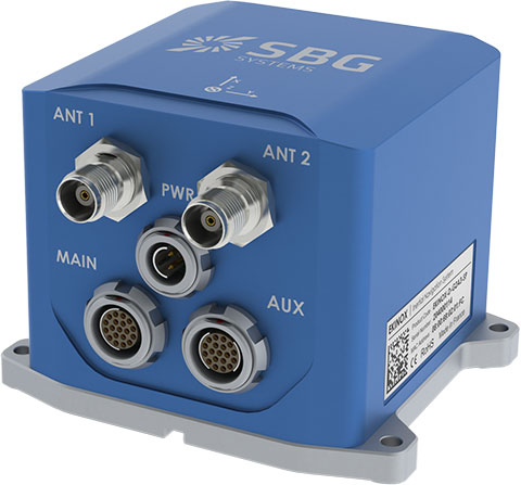
SBG Systems has added a new inertial system to its Ekinox Series. With integrated Dual Antenna GPS + GLONASS receiver, the Ekinox-D is a ready-to-use survey-grade inertial navigation system that provides consistent true heading (0.05°), SBG Systems said.
The Ekinox-D is a high-performance inertial navigation system that embeds a dual-antenna L1/L2 GNSS receiver to deliver more robust heading and position, while increasing satellite reception availability. Ekinox-D is an integrated system: GNSS data and inertial information are fused by an Extended Kalman Filter (EKF) to improve data integrity. This computation allows the system to achieve 0.05° roll, pitch, and true heading; 5-cm heave; and 2-cm RTK GNSS position.
The Ekinox-D is an all-in-one Solution for demanding applications. Instead of mounting separate GNSS receiver and inertial systems on a boat, car, or plane, the Ekinox-D can be installed and connect it to a camera, SONAR, or LiDAR system. With its 8-GB datalogger and its high output rate (200 Hz), Ekinox-D joins simplicity and performance for applications where robust heading is required such as surveying and hydrographic applications, unmanned system navigation, and auto testing.
The IP68 Ekinox Series brings robust, maintenance free, and cost-effective MEMS to the next level thanks to a drastic selection of high-end MEMS sensors, an advanced calibration procedure, and powerful algorithm design, SBG Systems said, adding that compromise is no longer required between high accuracy and cost.
Hemisphere GNSS has launched its new Crescent Vector H200 GNSS compass module, a high-performance receiver for heading, positioning, heave, and attitude. Vector H200 is designed for professional marine, navigation, and land applications in challenging and dynamic environments.
Vector H200 processes L1 GPS and GLONASS signals to deliver precise heading, greater positioning reliability, and better performance in challenging environments, Hemisphere GNSS said. Through using two separate antennas, Hemisphere GNSS’ patented Vector technology computes the heading and pitch or roll angle while stationary or in motion. Vector H200 can compute heading accuracy to 0.02 degrees using a 5-meter antenna separation. A variety of differential correction methods also make it possible for Vector H200 to provide sub-meter to centimeter position accuracy.
Marine industry developers can maximize performance by integrating Vector H200 into their systems for hydrographic and bathymetric surveys, auto-pilots, dredging, and buoys. For land applications, Vector H200 is ideal for aligning cameras, antennas and projectiles, and for machine control applications in agriculture, construction, and mining.
“System integrators have a lot to gain from Vector H200’s powerful combination of navigation and machine control orientation capabilities,” said Ron Ramsaran, Sr. Product Marketing Manager at Hemisphere GNSS. “They will appreciate the performance and value from such a small board package.”
Vector H200 supports SBAS, L-Band and RTK differential positioning solutions and features our exclusive SureTrack technology optimizing the use of GPS and GLONASS signals. Hemisphere GNSS offers precise GNSS antennas to fit a variety of Vector H200 applications.
Denver International Airport (DIA) has fully implemented its new arrival and departure procedures, the next phase in the Federal Aviation Administration’s mass overhaul of U.S. airspace, called NextGen. Denver is among the airports at the front end of the adoption process, and is highlighted in an in-depth feature in the Denver Post.
According to the article, “The recently completed phase at DIA trims arrival and departure fuel costs by eliminating several intermediary steps. The traditional system requires an airplane to come into and out of cruising altitude by firing its thrusters at every new altitude level, wasting hundreds of pounds of fuel… The traveling public will not likely notice an immediate difference in travel time, but proponents hope that the early investment pays off in the end.”
The FAA predicts that NextGen improvements will reduce flight delays by 38 percent and lead to a 1.4-billion-gallon total reduction of fuel burn by 2020.
Accord Technology’s NexNav GPS receiver will be supporting FreeFlight Systems with its recently awarded FAA Capstone Retrofit Project. In March 2013, FreeFlight and Accord announced their collaboration to develop practical and cost-effective ARINC 429 WAAS GPS solutions that enable aircraft operators to meet ADS-B, RNP (0.3) and other performance-based navigation mandates, worldwide.
The NexNav Circuit Card Assembly (CCA) will integrate with FreeFlight’s upgraded automatic dependent surveillance-broadcast (ADS-B) avionics to fulfill the requirements of the second phase of the FAA Capstone Project.
“This is an excellent example of how we are working closely with FreeFlight Systems to create state-of-the-art NextGen solutions that are not only meeting upcoming mandate requirements but doing it in a cost effective manner,” stated Hal Adams, Chief Operating Officer for Accord Technology, LLC.
The Accord Technology NexNav product line revolves around two key receivers, NexNav mini and NexNav MAX. The receivers are at the heart of embedded customer solutions whether as a Circuit Card Assembly (CCA) or embedded in the Line Replacement Unit (LRU) as a stand-alone GPS solution.
NexNav mini was the industry’s first GPS receiver and sensor qualified to fully support the known worldwide and U.S. FAA ADS-B GPS source requirements The NexNav mini and MAX are compatible with EGNOS and other Satellite Based Augmentation Systems (SBAS) to the extent they are is compatible with WAAS.
Maiden flight trials have been successfully conducted in Moldova using GMV’s magicSBAS solution. These trials form part of a GMV-led European Commission FP7 collaboration project.
In 2011 the European GNSS Agency (GSA) awarded GMV the EEGS2 project (EGNOS Extension to Eastern Europe). The main objective of the project is to demonstrate through flight trials the benefits of the European Geostationary Navigation Overlay Service (EGNOS) in areas of Eastern Europe where it is not yet available, such as Poland, Romania, Ukraine, Moldova and Russia, and to prepare the civil aviation authorities and air navigation service providers for future use of the system.
In the context of this project, after the tests conducted in Spain, the maiden flights have been successfully carried out in Moldova, using the equipment and tools developed by GMV. The Moldova demonstrations have given pilots and service providers a clear idea of the potential benefits of EGNOS and the flying procedures of the near future, GMV said.
Four flights had previously been conducted in Spain in November, December and February. The satisfactory results of these flights then paved the way for the demonstrations in Moldova.
The magicLPVsystem, developed under this project, enables LPV approaches (localizer performance with vertical guidance) to be carried out using the signal generated by the magicSBAS application. This test environment allows any region of the world to analyze the air-navigation benefits to be obtained with deployment of a Space Based Augmentation System (SBAS). This signal is read by Internet and transmitted by radio frequency in the vicinity of the airport, allowing LPV approaches to be made in places where SBAS is either completely unavailable or available only on a very limited basis.
Eight flights in all were carried out in various Moldovan airports, including Chișinău International Airport. Test results were highly satisfactory, demonstrating the simplicity of equipment configuration and operation, and the performance of the magicSBAS signal, GMV said.
“These trials are an important milestone for GMV, for the project and, fundamentally, for the use of EGNOS in the countries of Eastern Europe in the near future,” said Miguel Romay, executive director of GNSS–Aerospace.
GMV will continue with these demonstrations in other countries of Eastern Europe. The next trip in two weeks will be to Romania, where new flights are expected to be just as successful.
NovAtel’s single-box SPAN-CPT GNSS/INS receiver now supports the company’s next-generation OEM6 GNSS technology platform. The OEM6 GNSS engine significantly improves positioning performance through its support of GPS and GLONASS, all-in-view satellite tracking and intelligent measurement selection, the company said.
“We kept the design of the enhanced SPAN-CPT identical to our legacy product to ensure a seamless upgrade process for our customers who would like to take advantage of the improved positioning capabilities,” said Jason Hamilton, NovAtel director of marketing. “The enhanced SPAN-CPT is fully backwards compatible with the previous generation of product. It retains the same compact form factor with identical pin-out and log structure.”
As with the previous generation product, the upgraded SPAN-CPT integrates NovAtel’s precision receiver technology with fiber optic gyro and MEMS accelerometer inertial components from KVH Industries in one compact unit. The tight-coupling of the GNSS and INS technologies optimizes the raw GNSS and IMU data, delivering a superior position, velocity and attitude solution, NovAtel said. Comprised entirely of commercial components, the SPAN-CPT minimizes the operational complexities of working across international boundaries.
Production of the OEM6 supported SPAN-CPT begins June 1.
Houston’s George Bush Intercontinental Airport (IAH) became fully operational with the first precision approach flown by a United Airlines aircraft using Honeywell’s SmartPath Ground Based Augmentation System (GBAS) on April 22. IAH is one of two airports in the country participating in a pilot program, in partnership with the Federal Aviation Administration (FAA), United Airlines and Honeywell to demonstrate the use of GBAS. This new system delivers a cost-effective solution to increase airport capacity, decrease air traffic noise and reduce weather-related delays.
“The Houston Airports are among the most innovative and progressive in the nation when it comes to safety and efficiently connecting passengers to destinations around the world,” said Mario Diaz, director of the Houston Airports. “It is imperative that we continue to invest in new technology that enhances the aviation sector.”
Honeywell’s SmartPath GBAS system augments GPS signals so they can be used for precision navigation in the approach and landing phases of flight. The flexible approaches provided by GBAS may produce a significant reduction in aircraft delays and carbon emissions at airports. The project is a component of the Federal Aviation Administration (FAA) Next Generation Air Transportation System (NextGen). It’s a migration from what is considered to be a ground-based air navigation system to a satellite-based navigation system which uses the same GPS that you use in your cars today.
“There is a great opportunity for SmartPath to modernize the flight experience for airline passengers,” said Pat Reines, senior manager, SmartPath Ground Based Augmentation Systems at Honeywell Aerospace. “We’re looking forward to helping Houston passengers and visitors’ experience more flights that depart and arrive on time.”
United Airlines will operate the flights with a Boeing 737 aircraft equipped with global navigation satellite system (GNSS) landing system (GLS) technology to receive the GBAS landing approach data. United was an early leader in NextGen technology, taking delivery of GLS-equipped aircraft since 2009.
“We believe that GBAS is the air carrier precision landing system of the future,” said Captain Joe Burns, United’s managing director of technology and flight test. “We continue to work closely with the FAA and our industry partners on GBAS and other NextGen initiatives.”
GBAS can provide aircraft with guidance to as low as 200 feet above the surface of the runway, referred to as a Category I approach. The FAA is currently validating the requirements for a GBAS to support Category II and Category III precision approach operations which would guide an aircraft to the surface of the runway. GBAS represents the only currently feasible satellite-based navigation solution for Category II/III precision approach operations, according to the Houston Airport System.
A major exhibition opening April 12, “Time and Navigation: the untold story of getting from here to there,” explores how revolutions in timekeeping over three centuries have influenced how people find their way. This project is a unique collaboration between two of the Smithsonian’s largest and most popular museums: the National Air and Space Museum and the National Museum of American History.
“Time and Navigation is an ambitious exhibit because it traces the development of very complicated technologies and makes us think about a subject we now take for granted,” said Gen. J.R. “Jack” Dailey, director of the museum. “Today, the technology needed to accurately navigate is integrated into mobile computers and phones: hundreds of years of technological heritage tell your handheld device where you are in a seamless manner. This opens up new possibilities and challenging questions for the next generation of scientists and explorers who visit this exhibit to start thinking about.”
The gallery is organized into five sections and spans three centuries of efforts to travel on Earth and through the solar system. In each section the visitor will learn about pioneer navigators facing myriad issues, but one challenge always stands out: the need to know accurate time.
Sections
This timekeeper was the first American-made marine timekeeper taken to sea. William Cranch Bond, a 23-year-old Boston clockmaker, crafted it during the War of 1812.
Navigating at Sea is an immersive environment that suggests a walk through a 19th-century sailing vessel. Visitors will learn how centuries ago navigators at sea relied on chronometers and measurements of celestial objects to determine location. This section includes a mariner’s astrolabe, dating from 1602; a Ramsden sextant and dividing engine; several chronometers; a model of Galileo’s pendulum clock; and the earliest sea-going marine chronometer made in the United States, produced by Bostonian William Cranch Bond during the War of 1812. It also features an interactive display that allows visitors to use a sextant to navigate with the stars.
Navigating in the Air relates how air navigators struggled with greater speeds, worse weather and more cramped conditions than their sea-going predecessors. It tells the story of the innovations that overcame these challenges, as represented the gallery’s largest artifact, the Lockheed Vega “Winnie Mae,” flown by Wiley Post and Harold Gatty, shattering the around-the-world record in 1931. Visitors will learn that Charles Lindbergh required navigational tutoring after he flew to Paris and how he paved the way for a new system of navigation in the process. A personal account by a WWII navigator highlights wartime innovations. This section ends with an explanation of how clocks with tiny quartz crystals opened an entirely new era of navigation in the form of LORAN (LOng RAnge Navigation).
Wiley Post’s Winnie Mae circled the globe two times, shattering previous records. The first time was in 1931 with Weems associate Harold Gatty as lead navigator. The second was a solo flight in 1933 assisted by “Mechanical Mike,” one of the world’s first practical autopilots.
Navigating in Space traces how teams of talented engineers invented the new science of space navigation using star sightings, precise timing and radio communications. This section includes an Apollo sextant, a space shuttle star tracker, timing equipment used at a ground tracking station and a flight spare (duplicate spacecraft) of Mariner 10, the first spacecraft to reach Mercury.
Inventing Satellite Navigation describes how traveling in space inspired plans to navigate from space. Innovators found that time from precise clocks on satellites, transmitted by radio signals, could be used to determine location. The U.S. military combined several breakthroughs to create the Global Positioning System. Some of the artifacts in this section are the NIST-7 atomic clock that served as the U.S. time standard in the 1990s, the navigation system from the nuclear submarine U.S.S.Alabama, a satellite from the Transit system used for global navigation before GPS and a test satellite global navigation built at the Naval Research Laboratory.
An official DARPA photograph of Stanley at the 2005 DARPA Grand Challenge. Stanley, created by the Stanford University Racing Team, won the race.
Navigation for Everyone tells the stories of real people — a fireman, a farmer and a student — who use modern navigation technology in their everyday lives. It also addresses what might come next: the story is not over yet and many new technologies are being developed. This section includes a disassembled mobile phone with a diagram showing all its parts and depicts how hundreds of years of navigation technology are now in the palm of a user’s hand. It also features “Stanley,” the robot car that won the 2005 Grand Challenge, a robot race sponsored by the Defense Advanced Research Projects Agency.
The exhibition is made possible through the support of Northrop Grumman Corporation; Exelis Inc.; Honeywell; National Geospatial-Intelligence Agency; U.S. Department of Transportation; Magellan GPS; National Coordination Office for Space-Based Positioning, Navigation and Timing; Rockwell Collins; and the Institute of Navigation.
The National Air and Space Museum building on the National Mall in Washington, D.C., is located at Sixth Street and Independence Avenue S.W. The museum’s Steven F. Udvar-Hazy Center is located in Chantilly, Va., near Washington Dulles International Airport. The National Museum of American History collects, preserves and displays American heritage in the areas of social, political, cultural, scientific and military history.
Aeroflex Incorporated, a wholly owned subsidiary of Aeroflex Holding Corp., has announced its capability to simulate WAAS (Wide Area Augmentation System) LPV (Localizer Performance with Vertical Guidance) approaches by adding this new feature to their GPSG-1000 Portable GPS Simulator.
Aeroflex has developed the capability of simulating WAAS LPV approaches to expedite and validate the installation of WAAS-enabled navigation systems in aircraft. The GPSG-1000 offers the following features to installers of these systems:
Ability to perform structured, repeatable dynamic motion tests (actual flight) of a WAAS/LPV installation,
Ability to check and validate the sensitivity and dynamic range of an airborne GPS receiver, either statically or while in motion,
Reduce aircraft down time and flight demonstration time required by FAA,
Additional support data for documenting proper FAA processes of WAAS/LPV system upgrades or installs without leaving the hangar.
New orders for the GPSG-1000 are ready for immediate delivery. For existing GPSG-1000 customers, a no-charge software upgrade will be available by mid-April 2013.
The FAA created the WAAS program in 1992 to provide the necessary integrity to utilize GPS signals for precision approach. The WAAS consists of a network of precisely surveyed wide area reference stations (WRS). These reference stations monitor GPS satellites to determine errors in the GPS satellite signal. Each reference station relays the information about the GPS satellites to the WAAS wide area master stations (WMS). The master station then develops corrections to the GPS position information and provides timely notification of unreliable GPS data. These corrections are sent to ground uplink stations (GUS) where they are transmitted in the form of a WAAS correction message to a Geostationary Earth Orbit (GEO) satellite. The WAAS signal is then broadcast to users on the same frequency as GPS. This WAAS corrected signal provides three-dimensional guidance to aircraft.
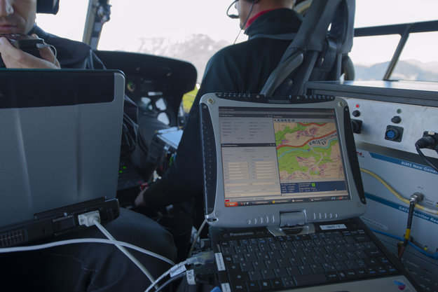
Europe’s two satellite navigation systems could combine in the future for heightened performance, an airborne test has confirmed. A helicopter flight took place above an alpine valley in Germany, the one place on Earth where Galileo services are already routinely available.
The test receiver. The helicopter flew a variety of maneuvers, from fast loops to mid-air hovering, to see how satnav signals were received in practice.
Results of the flight test, conducted in September 2012, show that adding Galileo signals to the European Geostationary Navigation Overlay Service (EGNOS) should boost its accuracy significantly. EGNOS, which augments the accuracy and reliability of GPS signals over Europe, renders satnav usable for safety-critical applications such as aircraft guidance, as well as more general precision uses.
Operational horizontal and vertical distance “protection levels” for safety were cut by half by combining use of GPS and Galileo within EGNOS. In addition, new integrity algorithms installed within the user receiver turned out to reliably detect and exclude reflected or otherwise faulty signals.
The first test of real Galileo navigation fixes is scheduled for later this year from the four satellites already in orbit, with more satellites set to join them by the end of the year.
The Galileo Test and Development Environment – GATE – is a giant outdoor laboratory where prototype Galileo receivers can be used freely without any modifications.
As the constellation takes shape, satnav researchers and industrial developers can already try out Galileo services with prototype receivers at the German Galileo Test and Development Environment, or GATE, a giant outdoor laboratory. GATE, in and around the town of Berchtesgaden in the Bavarian Alps, is Europe’s go-to place for Galileo testing: transmitters atop eight neighbouring mountains cover 65 square kilometers of territory with simulated Galileo signals.
ESA’s Global Navigation Satellite System Evolution program carried out helicopter-based testing here on September 24–26. The results will help to guide the development of next-generation satnav systems.
The helicopter flew a variety of maneuvers, from fast loops to mid-air hovering, to see how satnav signals were received in practice. The test relied on ESA’s SPEED platform — Support Platform for EGNOS Evolutions & Demonstrations, co-funded by French space agency CNES and operated by Thales Alenia Space France — which enabled the receiver to receive simultaneous realtime augmentation for both GPS and Galileo.
Europe’s next-generation EGNOS, planned for around 2020, is envisaged to operate in the same way, with augmentation of both constellations and dual-frequencies at the same time making the system much more robust.
A helicopter flies over the Galileo Test and Development Environment – GATE – in Berchtesgaden, Germany, gathering data on how EGNOS and Galileo will work together. The promising results from the testing are now being analyzed.
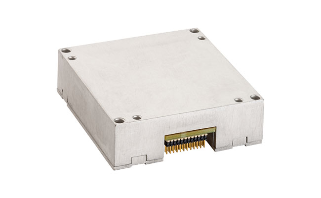
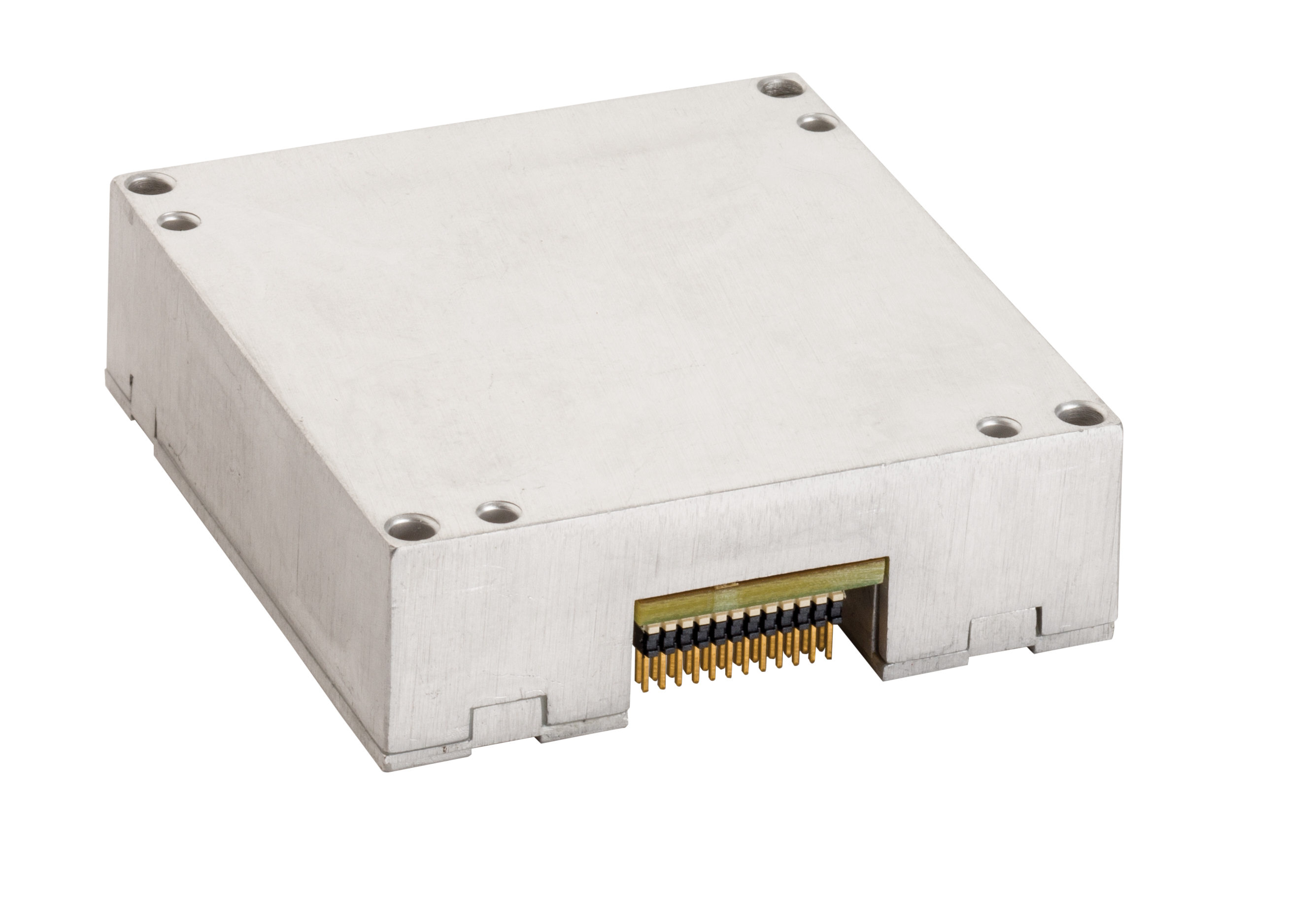
NovAtel Inc., supplier of OEM GNSS components and subsystems, has announced the addition of a new commercially exportable MEMS IMU to its line of SPAN GNSS/INS products. Available for immediate shipping, this custom Analogue Devices MEMS inertial sensor is exclusive to NovAtel, and can be paired with an OEM6 receiver card to provide continuously available position, velocity and attitude (roll, pitch, yaw) in a small, single-unit form factor.
SPAN tightly couples NovAtel’s precise GNSS technology with highly accurate inertial measurement technology to provide a robust, stable and continuous 3D navigation. The new OEM-ADIS-16488 sensor is designed to be coupled with NovAtel’s OEM6 receivers via the MEMS Interface Card (MIC), providing integrators with a compact, powerful GNSS/INS engine, NovAtel said.
The OEM-ADIS-16488 features low noise gyros and accelerometers in a small, lightweight form factor. This IMU enables precision measurements for applications that require low cost, high performance and rugged durability. Tight-coupling of the two technologies enables continuous robust positioning in difficult environments where satellite signals are unreliable or unavailable for short periods of time.
The OEM-ADIS-16488 is now available for order and immediate shipment.
The ADIS16488 is a Micro Electromechanical System (MEMS) Inertial Measurement Unit (IMU) from Analog Devices. It features low noise gyros and accelerometers in a rugged, environmentally sealed enclosure. The ADIS16488 enables precision measurements for applications that require low cost, high performance, and rugged durability.
At 71 x 46 x 11 millimeters, the OEM-ADIS-16488 features low noise gyros and accelerometers in a small, lightweight form factor. The custom device is designed to be paired with a NovAtel OEM6 receiver card to provide continuously available position, velocity, and attitude (roll, pitch, yaw).
SPAN tightly couples NovAtel’s precise GNSS technology with highly accurate inertial measurement technology to provide robust, stable, and continuous 3D navigation. Tight coupling of the two technologies enables continuous robust positioning in difficult environments.