When the U.S. Air Force shot down a Chinese balloon flying at 60,000 ft (11.4 miles) on Feb. 4, the incident raised many questions about international security, international law, U.S.-China relations and technology. Among them, where is the end of a nation’s airspace — the portion of atmosphere it controls above its territory? Its horizontal boundary corresponds to that of its land border and territorial waters, which extend 12 miles out from its coastline. However, there is no international agreement on the vertical boundary.
The 1967 Outer Space Treaty — to which the United States is a party and which bans “appropriation” of outer space by any nation — omits a definition of “outer space” because none of the major powers wanted to limit their own freedom of action in space. At a United Nations meeting in Vienna in 2001, the U.S. delegation said, “Our position continues to be that defining or delimiting outer space is not necessary.”
The United Nations has historically accepted as the boundary of space the Kármán line, at an altitude of 62 miles above mean sea level. It roughly marks the altitude where traditional aircraft cannot effectively fly using lift generated by Earth’s atmosphere, because the air there is just too thin. The Fédération Aéronautique Internationale agrees with this definition.
Some countries have adopted a definition for their own legal purposes, usually based on either the Kármán line or on the altitude at which orbital flight is possible without utilizing atmospheric lift. As a courtesy, a state launching a space vehicle that will traverse another state’s territory during its sub-orbital flight will notify the overflight state.
The U.S. military and NASA on the other hand, define space to begin at 50 miles above Earth’s surface. “Pilots, mission specialists, and civilians who cross this boundary are officially deemed astronauts,” according to the U.S. Department of Commerce’s National Environmental Satellite Data and Information Service.
Escaping Earth’s atmosphere entirely is another story. It requires traveling at least 600 miles, to its outermost layer, where violent solar winds have greater sway than air. If that were the definition of space, however, the Space Shuttle (which orbited up to 200 miles up), the International Space Station (205 miles to 270 miles), active Earth observation satellites (280 miles to 500 miles), some of the National Oceanic and Atmospheric Administration’ s polar-orbiting satellites (540 miles) and most scientific satellites, including nearly all of NASA’s Earth Observing System fleet, would not be considered spacecraft! Lower orbits have significant air-drag, which requires frequent orbit re-boost maneuvers.
There’s no question that GPS satellites, orbiting at an altitude of about 12,550 miles, are in space. That is why they are acquired, sustained, and operated by the U.S. Space Force (USSF), established in December 2019 as the newest branch of the U.S. armed forces. Its mission is to organize, train and equip space forces to protect U.S. and allied interests in space and provide space capabilities to the joint force. As the USSF grows, we’ll hear more about it.
“Seen & Heard” is a monthly feature of GPS World magazine, traveling the world to capture interesting and unusual news stories involving the GNSS/PNT industry.
Image: BanksPhotos/E+/Getty Images
Dozens Stranded in Tundra
Several vehicles in Rock Springs, Wyoming, were stranded after being led by their map apps or vehicle navigation systems to an unmaintained county road in a blizzard. Several calls were made to the Sweetwater County Sheriff’s Office about stranded vehicles stuck after they were directed to the detour when Interstate 80 was closed due to winter conditions. Similar incidents were reported by other counties, resulting in discussions between the Wyoming Department of Transportation and the companies that develop navigation software.
Screenshot: CBS video
UAVs contain Western Technology
A Ukrainian intelligence assessment obtained by CNN and CBS reported an Iranian UAV downed in Ukraine contained technology from companies in the United States and other western countries. The White House has since launched an investigation as to how the technology — including semiconductors, GPS modules and engines — were obtained by Iran. The components removed from an Iranian Shahed-136 UAV totaled 52, 40 of which were manufactured by 13 different U.S. companies. The remaining components were manufactured by other western companies and by companies based in Japan, Taiwan and China.
Researchers may now be able to monitor climate-induced natural hazards by combining satellite technology with machine learning. Researchers were able to use machine learning to study hurricanes that made landfall over the Gulf of Mexico in a series of recent experiments. C.K. Shum, the co-author of the study and a professor at the Byrd Polar Research Center, uses geodesy to study global climate change phenomena. Using geodetic data gathered from satellites, Shum tested whether a mix of remote sensing and machine learning analytics could accurately monitor weather phenomena. Accurate measurements could help improve hurricane forecasting.
Sailboat. (Image: valio84sl/iStock / Getty)
The power of TikTok is real
TikTok changed Jeff Foulk’s life when his daughter posted about his free marine navigation app, Argo, when they attended a boat show in Chicago. Foulk was promoting Argo with little success, until his daughter shared with the social media platform his struggle as the owner of a small business. Since then, the app has been downloaded more than 200,000 times and remains at the top of the charts for boat navigation apps. Argo was launched more than four years ago and, until now, had only 100,000 total downloads. Now that Argo is viral, Foulk wants to launch a premium subscription.
The International Symposium on Satellite Navigation 2023: Advances, Opportunities and Challenges (ISSN 2023) will take place Nov. 20-22 in Jiaozuo, Henan, China.
ISSN 2023 will provide a platform for GNSS scientists and engineers to communicate and exchange theories, methods, technologies, applications and future challenges.
The event is open to all scientists who may have the latest results and developments in BeiDou (BDS) and GNSS+, including constellations, signals, orbits, receiver design and multi-sensor fusion, as well as positioning, navigation and timing theory, algorithms, models and applications in engineering and Earth science.
Manuscripts on new advances in multi-GNSS and other regional systems, compatibility, interoperability and new applications are also welcome.
ISSN 2023 is jointly sponsored by Henan Polytechnic University and the Editorial Office of Satellite Navigation. Main topics and sessions include:
Feb. 4 saw the news networks alive with sometimes wild reports about UFOs, UAVs and then a balloon. Balloons are used for weather forecasting on a regular basis, launched daily into the stratosphere with payloads gathering wind speed and direction, temperature, humidity, pressure and, of course, position.
Synchronized twice a day at about 900 locations around the world, balloons are released into the stratosphere gathering essential atmospheric data to feed our weather forecasts. Reaching altitudes of 20 miles, these balloons often drift on winds as far as 125 miles from the release point, broadcasting measurements from their onboard sensors.
At first, maybe North American Aerospace Defense Command (NORAD) thought the balloon crossing into Alaska’s airspace was just one of these high-altitude weather prediction vehicles. Aircraft were apparently scrambled, and initially it was decided there was no threat, so the balloon was allowed to continue and enter Alaskan airspace. It was detected and subsequently tracked by both the United States and Canada for some time as it continued to drift on the jet stream over the border into the lower 48. Then, people in and around Billings Montana (home to one of the nation’s three nuclear missile silo fields at Malmstrom Air Force Base) started to send in reports of a very large balloon high overhead — according to one observer with a high-resolution camera, it even seemed to be stationary for 35 minutes.
Apparently, by the time the good folks in Montana were looking up, the Pentagon had decided the balloon was a Chinese surveillance vehicle. To get this detail, one or more U-2 high altitude reconnaissance aircraft had been dispatched to investigate. The collected U-2 information spotted markings of a Chinese manufacturer on the 200-foot-tall balloon. A payload the size of a small passenger jet dangled some 20 feet below the balloon canopy. It had several antennas of various configurations. A huge solar panel was attached — presumably to power its suite of surveillance sensors.
The Federal Aviation Administration (FAA) ordered a ground stop for all aircraft traffic at the Billings airport while decisions were made about downing the balloon or allowing it to proceed.
Meanwhile, it may seem obvious that both the United States and China have developed, launched and make use of surveillance satellites. I imagined that a couple of dozen of these space vehicles would be buzzing over not only each other’s landmass, but also surveilling dozens of other countries as they orbit the whole planet.
What I found was a report that China had at least 260 such orbital observation platforms in 2022, and the United States has even more. Isn’t that enough without resorting to lower-tech balloons?
It’s possible that some electronic transmissions are short range and would not be detected by surveillance satellites operating in geosynchronous orbit (22,000 miles out), or even at 300 miles where the International Space Station (ISS) and most surveillance satellites hang out. So, a slow-moving balloon at 20 miles up might be ideal to “sniff” ground transmissions from sensitive military installations, and if you could control the balloon to hover, all the better to pick up radio signals. Could the gathering of transmission data somehow be used to geo-locate the source? It’s something the U.S. military may be working on, too, as it is reportedly also building a fleet of autonomous dirigibles and balloons.
According to press reports, the United States decided not to immediately take down the balloon, even though it subsequently discovered its surveillance capabilities. Not only was there concern over debris falling on populated areas but allowing the balloon to continue its flight over the United States provided an opportunity to observe its behavior and gather useful information. U.S. bases along its path apparently shut down all communications in sequence, as the balloon passed overhead.
The balloon was apparently found to be transmitting – presumably reporting on where it was and what it had detected. But, at some time transmissions ceased, possibly when U.S. Air Force activity was detected nearby.
The take-down off Myrtle Beach
An F-22 flew to almost the same altitude as the balloon and fired an AIM-9X Sidewinder missile into it, leaving the payload to tumble from 60,000 feet into the shallow (50-foot deep) Atlantic Ocean off Myrtle Beach, South Carolina. Recovery boats were already on hand to pick up the collapsed canopy, and to begin locating the electronics payload on the seabed. At time of writing, the U.S. recovery effort has yet to inform us on finding the key electronic payload, which would go a long way to confirming the intended mission for the balloon.
Image: Screenshot of CNN news coverage
Strange, but a couple of days later over Canada, F-22s were again in action to take down a “cylindrical object” detected at 40,000 feet — an altitude posing a danger to airline traffic. Little has been released on what this object might have been — could it possibly be a re-entering piece of space debris? Again, debris recovery and analysis is underway, and we patiently wait for a public report about what this was all about.
What have we learned?
Both China and the United States operate huge fleets of surveillance satellites gathering intelligence daily about each other’s capabilities and those of other countries. Both China and United States have also invested in surveillance balloons, but China is the only country to send one over U.S. territory.
There may have been earlier balloon incursions, which are only now being reported. The U.S. response was initially to determine the configuration of the balloon and its payload, then to allow its journey along the jet stream to continue. The United States has said the balloon did not uncover anything already available by other means, but recovery and analysis of the payload would presumably confirm this announcement.
China is not happy about the U.S. takedown of a harmless, stray weather balloon. And what the heck were F-22s shooting at in Canada?
We’ll tell you more when we learn more….
Tony Murfin
GNSS Aerospace
Editor’s Note: Since the initial instance of an unidentified object floating across U.S. airspace — later identified as a Chinese surveillance balloon — three additional unidentified aerial objects were spotted in North American airspace. One was spotted in Alaska, one in northern Canada and one over the Great Lakes region. All three were shot down by U.S. fighter jets out of caution.
For farmers, every centimeter counts. ComNav’s AG360 Pro autosteering system controls pass-to-pass accuracy within 2.5 cm. (Image: Daniel Balakov/E+/Getty Images)
How do you define precision agriculture?
Precision agriculture uses new technologies to obtain as much as possible the unique characteristics of a field and input the correct amount of resources at just the right time. It is a system that needs to be implemented throughout the whole process of crop growth, including land preparation, tractor guidance, water management and weather monitoring. Tractors are used at every step, therefore it is critical to make them work consistently throughout the whole process, by using GNSS. ComNav Technology’s autosteering systems can be installed on most types of tractors. This allows farmers to grow the crops in a more autonomous and efficient pattern, which they can then save with high precision and reuse for later steps until harvest, increasing the utilization rate of land and decreasing the use of fuel, water, fertilizer and herbicides.
What have been the key turning points in the development of precision agriculture?
We have been in this sector since 2013. Our current solution is much easier to install and maintain and has higher accuracy and stability. The younger generation of farmers are more receptive to autonomous driving. They would like to try new things and set themselves “free” with technology.
What are the specific requirements and challenges of precision agriculture for GNSS, and how do they differ from those of other kinds of mapping and machine control?
The main challenges for autosteering systems include signal loss and terrain compensation. Most rural areas lack GSM coverages; therefore, in many countries using autosteering requires base stations. However, radio data links between stations far apart could be affected by obstacles, causing frequent correction outages. To compensate for this, ComNav has embedded in its GNSS module its “RTK-Keep” algorithm, which can maintain a relatively high-precision performance for autosteering during corrections outages. The system also must include various terrain compensation algorithms that identify a field’s elevation contours and provide smooth and continuous guidance even in complex terrains.
When did ComNav begin to focus on precision agriculture and why?
In 2013, we introduced our first high precision GNSS board. Initially, our main role was to provide it to integrators with expertise in precision agriculture. Over the years, the market began to boom in China and in 2016 we announced our first generation autosteering system for tractors. The main reason for us to focus on precision agriculture is the increasing demand from the market, which we believe will continue to grow in the foreseeable future due to the increasing demand for food from Earth’s growing population.
What are your relevant products/product lines?
In the past, workers in China drew lines on the land and then planted potatoes roughly along those lines, which was challenging and time consuming. It was hard for the farm owner to hire an experienced driver and guarantee the effectiveness of seeding. Now, however, ComNav Technology’s AG360 Pro autosteering system solves that problem by guiding vehicles according to set routines, including straight lines, curves, automatic turns and headline turns. Importantly, the pass-to-pass accuracy can be controlled to within 2.5 cm. The worker can finish multiple processes within only 24 hours, such as ridging, ditching, sowing, fertilizing and laying drip irrigation under mulch. Furthermore, compared to traditional manual planting, mechanized planting produces a more even sowing rate, which also establishes the foundation for the automated harvesting of potatoes. Potato production has increased by 10% per acre, land use has been reduced by more than 20%, and labor costs have been reduced significantly.
On Jan. 3, Hexagon and Dayou announced the availability of TerraStar-X Enterprise test beds in Beijing, Shanghai, Anqing and Shenzhen for OEMs in the automotive and micro-mobility industries. Terra-Star-X Enterprise precise-point positioning corrections provide lane-level accuracy with fast convergence for autonomous vehicles and mass-market use.
The availability of the test beds follows the initial announcement by Hexagon’s Autonomy & Positioning division and Dayou of their partnership aiming to deliver GNSS correction services to the Chinese market. Users of autonomous platforms will now have a single correction service that works in China, North America and Europe.
OEMs in China can now leverage the test beds with consumer and automotive-grade GNSS receivers to design advanced driver assistance systems (ADAS), and other products, such as mobile applications, safety-critical solutions and more.
In 2022, the BeiDou Navigation Satellite System (BDS) continued to improve its service performance, expand global applications, and deepen and promote international cooperation.
On Nov. 4, 2022, a white paper titled “China’s BeiDou Navigation Satellite System in the New Era” was published. The paper shows the continuous, stable and reliable operational capability of BDS, its applications achievements across the industries, international development with openness and integration, and unremitting pursuit of helping to build a community with a shared future for humanity and a better world.
System Services Performances
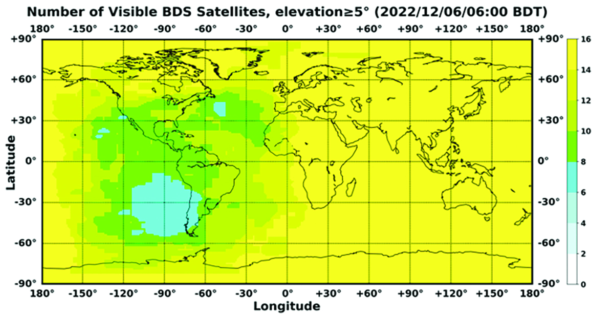
In orbit are 45 BDS operational satellites, including 15 BDS-2 satellites and 30 BDS-3 satellites. Figure 1 shows the number of visible BDS satellites worldwide as of BDT 06:00 on Dec. 6, 2022.
Figure 1. Number of visible BDS satellites. (Image: www.csno-tarc.cn)
BDS has reached a continuity of 99.996% and an availability of 99%. The innovative constellation involves inter-satellite links, signal system optimization, intelligent operation and maintenance, software reconstruction and upgrading of in-orbit satellites, and global test and assessment.
As measured by the International GNSS Monitoring and Assessment System (iGMAS), the BDS global positioning accuracy is less than 1.5 m horizontally and 2.5 m vertically (95% confidence) — better than the nominal service performance parameters.
So far, the measured signal power spectrum envelope of the BDS satellites remains consistent with the superior signal quality; the signal-in-space accuracy of any BDS satellite is better than 4.6 m. The time offset between BDT and UTC (NTSC) remains within 26 ns.
The BDS Coordination Framework has maintained consistency with the International Terrestrial Reference Frame 2014, and the accuracy is better than 3 cm. The orbital accuracy of the broadcast ephemeris of the BDS-3 medium Earth orbit (MEO) satellite is better than 0.5 m, and the clock offset of the broadcast ephemeris of the BDS-3 satellites is better than 5 ns.
BDS concentrates on construction of the application infrastructure and has established four major characteristic service platforms:
Short Message Communication Service
Satellite-based Augmentation System Service
Search-and-Rescue Service
Ground Based Augmentation System Service.
These platforms will expand and upgrade the applications and provide more efficient and convenient services for users.
The BDS Short Message Communication Service platform realizes the interconnection with ground mobile communication systems and networks, and integrates the BDS short message communication functionality into smartphones without the need to change the SIM card or contact number.
For the BDS Satellite-based Augmentation System Service platform, the system’s ground segment includes 30 monitoring stations and two data processing centers. The system will provide single frequency (SF) and dual-frequency multi-constellation (DFMC) services through GEO satellites. The Civil Aviation Administration of China has initiated and organized the technical testing and certification of SF service before applications.
The BDS Search-and-Rescue Service provides users with distress alert information access and distribution, as well as return link services. It is currently at the initial operational stage with sound performances. The operational status of the BDS SAR payload has been submitted to Cospas-Sarsat.
The BDS Ground-Based Augmentation System Service platform’s real-time positioning accuracy can reach 2 cm horizontally and 5 cm vertically. The post-processing accuracy can reach 2 mm horizontally and 5 mm vertically. At present, the BDS ground-based augmentation network has provided the A-BDS positioning and the BDS high-precision services for more than 1.5 billion users in more than 230 countries and regions, with services delivered 2 trillion times in total, equivalent to nearly 3 billion on average per day. BDS has provided high-precision positioning services for more than 20 million mobile phones in the country.
The BDS Applications Industry
The BDS applications industry has achieved sustainable development. In 2021, the total output of China’s satellite navigation and location-based service industry reached about 469 billion yuan (about 67.4 billion U.S. dollars), with a compound annual growth rate of more than 20%. A complete industrial chain covering chips, modules, antennas, boards, terminals and services has been established.
Industrial applications. BDS has been fully applied in various industries — including transportation, agriculture, forestry and fishery, public security, disaster mitigation and relief — and has been integrated into infrastructure such as electric power, water conservation, finance and communications.
As BDS applications fields expand, its in-depth applications have been growing as well. As of June 2022, more than 8 million BDS terminals had been installed in the transportation sector. More than 1.3 million terminals were used in the farming, forestry, livestock and fishing industries, and more than 1.8 million terminals were adopted by public security agencies. Large-scale BDS applications have been advanced in communication and timing services, meteorological monitoring, emergency response and disaster mitigation, and urban management. In emerging applications sectors, BDS has served epidemic prevention and control, telemedicine, caring for seniors, promoting the realization of intelligent health services that serve everyone, and accelerating intelligence and modernization in related fields.
Mass market applications. BDS has been widely used in mass market applications, such as mobile phones and wearable devices. In the first half of 2022, among all types of smartphones that applied for network access in China, 128 supported the BDS-based positioning function. More than 130 million smartphones supporting BDS services were shipped, accounting for more than 98% of the country’s total volume. The BDS positioning service is used more than 100 billion times daily on average for a platform that supports mobile map navigation. In particular, mobile phones have been fitted with high-precision positioning services. Lane-level navigation has been implemented in eight cities in China, including Shenzhen, Chongqing and Tianjin. The first mobile phone in the world that supports BDS-3 regional short message communication services has been officially released, enabling users to send short messages through BDS.
BDS international applications. BDS has been applied in more than half the countries and regions in the world, with more diversified application modes and application fields.
BDS products, technologies and services have been recognized by more international users:
In Mozambique, BDS-based UAVs have greatly improved the efficiency of plant protection operations
In Lebanon, BDS-based high-precision technology has been successfully applied to the construction and measurement of the port of Beirut
In Burkina Faso, BDS supported surveying and mapping during the construction of hospitals to prevent and control local infectious diseases, such as COVID-19
In Saudi Arabia, BDS is widely used in fields such as surveying and the collection of geographic information, the construction of urban and municipal infrastructure, and the positioning of personnel or vehicles in deserts
In Asia, BDS-based high-precision positioning services are contributing to the monitoring of Sarez Lake Dam in Tajikistan, the completion of the China-Kyrgyzstan-Uzbekistan Highway, the China-Kazakhstan crude oil pipeline, and the routine operation of China-Europe Railway Express.
International Cooperation
Following the principles of openness, cooperation and resource sharing, BDS has been actively carrying out practical international cooperation and exchanges as well as facilitating the development of global satellite navigation.
Multilateral cooperation. BDS representatives continue to participate in international activities under the framework of the United Nations International Committee on GNSS and other multilateral forums, to advocate joint development of global satellite navigation by contributing Chinese wisdom and proposals. BDS has also participated in international academic conferences in the field of satellite navigation, such as the Institute of Navigation meetings, the Munich Satellite Navigation Summit, and the Multi-GNSS Asia Conference.
Bilateral cooperation. The Ninth Meeting of the China-Russia Project Committee on Major Strategic Cooperation in Satellite Navigation was successfully held in September 2022. Under the framework of the Committee, BDS and GLONASS have carried out continuous cooperation in such areas as compatibility and interoperability, system performance testing and assessment, and joint applications. China’s Satellite Navigation Office signed cooperation documents in the field of satellite navigation with partners from the United Arab Emirates and the Arab Civil Aviation Organization, to carry out extensive cooperation and continue to deepen cooperation with Pakistan, Iraq, Thailand, Argentina, South Africa and other countries.
International Standards. BDS is increasingly recognized by international organizations such as the International Maritime Organization (IMO), the International Civil Aviation Organization (ICAO), Cospas-Sarsat, IEC, 3GPP and RTCM. In November 2022, the BDS Message Service System (BDMSS) was ratified by the Global Maritime Distress and Safety System (GMDSS), making BDMSS the third GMDSS satellite communication system recognized by the IMO. The Declaration of Intent for Cospas-Sarsat MEOSAR Cooperation was signed between the cooperating agencies (from Canada, France, Russia, and the United States) of the International Cospas-Sarsat Program and the Maritime Safety Administration of China, meaning China formally becomes the provider of the Cospas-Sarsat space segment.
The Future
In the future, BDS will launch back-up satellites to ensure better performance by upgrading the constellation’s availability. While maintaining stable operation, BDS will speed up in combination with new technologies such as 5G, artificial intelligence and Big Data to build a more ubiquitous, more integrated, and more intelligent national comprehensive PNT system by 2035. BDS will continuously adhere to the development concept that “BDS is developed by China, dedicated to the world and aiming to be world class,” promote system development and make contributions to social development and construction of the community with a shared future for mankind.
For analogous updates on the other three GNSS constellations, please see:
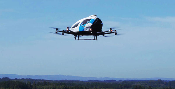
EHang deployed its EH216 eVTOL for flight trials in Europe including the recent Air Mobility Urban-Large Experimental Demonstration. (Photo: EHang)
EHang will deploy its EH216 autonomous aerial vehicle in a European Union-funded project that is assessing how the European Geostationary Navigation Overlay Service (EGNOS) could be used for electric vertical-takeoff-and-landing (eVTOL) aircraft operations.
The fully autonomous, all-electric vehicle will be used for flight trials at Lleida-Alguaire Airport in Spain as part of the Satellite Based Augmentation System Adoption in Multicopter VTOL Aircraft (SAMVA) program.
As part of an initiative of the European Union Agency for the Space Programme (EUSPA), the SAMVA project is tasked with establishing how EGNOS could support planned air mobility services, including eVTOL air taxi flights. It is also intended to prepare for uncrewed vehicles to use the new U-Space concept for managing autonomous or remotely piloted aircraft.
Aeroports de Catalunya will help China-based EHang to establish an operational center at its Lleida-Alguaire facility in the Catalonian region of northeast Spain. The EH216 will use the EGNOS technology to conduct unmanned traffic management (UTM) tasks and to demonstrate how eVTOL aircraft could operate in urban environments, including to and from airports.
EHang is working to achieve Chinese certification for the two-seat EH216, which it intends to deploy with partners and customers for services such as air taxi and sightseeing flights. It also aims to get approval for its aircraft to operate in Europe and has been active in other air mobility partnerships in Europe, where it has provisional customers in places like Norway.
In October, EHang completed its participation in the European Union’s Air Mobility Urban-Large Experimental Demonstration (AMU-LED) with a series of flight tests in Spain. The company — one of 16 consortium members in the AMU-LED program — demonstrated the EH216 at the Rozas Airborne Research Center, which is part of Spain’s National Institute of Aerospace Technology.
“The SAMVA project will unleash EGNOS capabilities aboard EHang’s EH216 AAV to provide precise and integral navigation guidance and support U-Space airspace integration,” said Victoria Jing Xiang, the company’s chief operating officer for Europe and Latin America. “Our participation in this project reflects the meaningful progress we’ve made overseas with our strong technologies as our global footprint expands.”
Chinese scientists say they have succeeded in an experiment that could improve satellite navigation and redefine the second as a unit of time, reports the South China Morning Post.
The scientists performed the experiment in Urumqi, capital of Xinjiang Uygur autonomous region in western China. They placed two terminals in laboratories 113 km (70 miles) apart. Each terminal was equipped with a laser, a telescope and two optical frequency combs that measure exact frequencies of light. Laser pulses sent between the terminals allowed researchers to confirm the time.
The research team was led by quantum physicist Jian-Wei Pan at the University of Science and Technology of China (USTC).
Sending signals over long distances would enable a global network of optical clocks that can help improve the accuracy of satellite navigation services.
China also is sending three atomic clocks to its Tiangong space station to establish a space-based timekeeping system of exceptional accuracy. The clocks can work together to measure time with 10-19 stability, missing only one second every few billion years, and is expected to be thousands of times more accurate than a hydrogen maser.
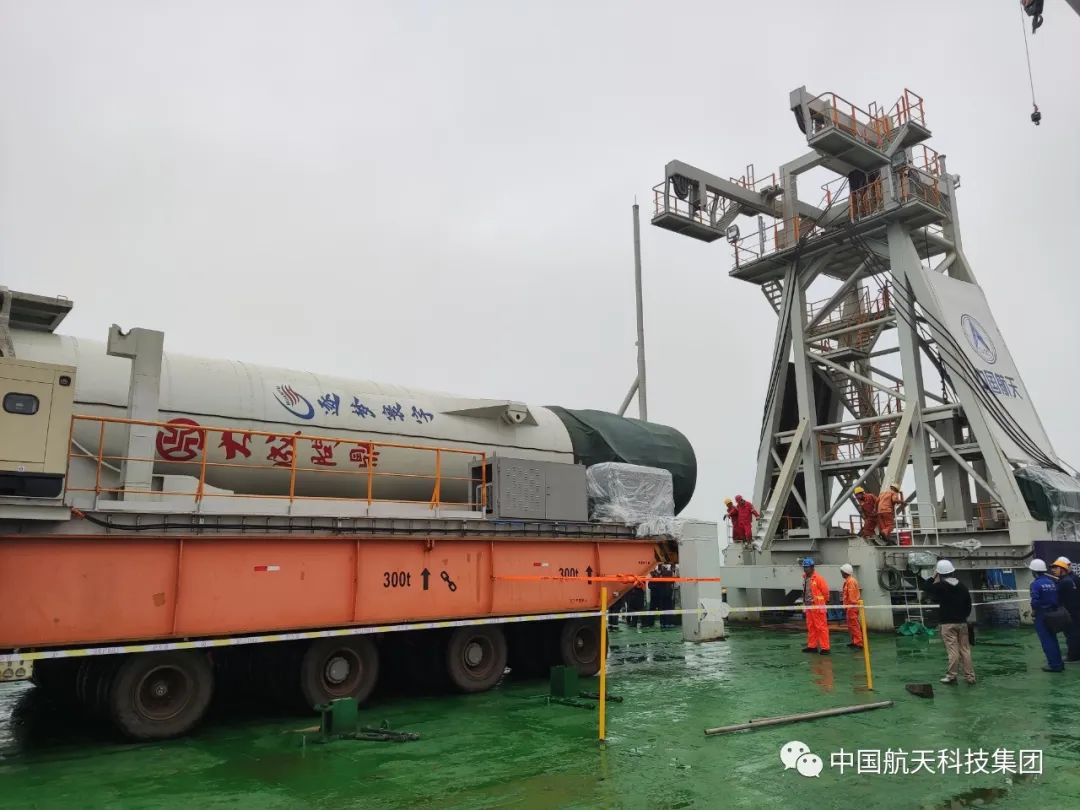
On Oct. 7, China launched a pair of satellites designed to enhance BeiDou navigation signals.
The CentiSpace-1 S5 and S6 satellites were launched via a Long March 11 solid rocket that lifted off at 9:10 a.m. EDT from a mobile sea platform in the Yellow Sea. Launch success was confirmed by the China Aerospace Science and Technology Corporation (CASC) 90 minutes later.
The CentiSpace-1 satellites are designed to enhance the accuracy of signals from China’s Beidou navigation and positioning satellite system. The satellites will also conduct inter-satellite laser link experiments.
Transportation Secretary Pete Buttigieg made a surprise appearance at the DOT roundtable on complementary PNT. (Screenshot: DOT)
“If this is a problem, the government should act like it.”
Citing more than 10 years of government studies, warnings and promises, representatives from a wide variety of industries criticized the government recently for doing little to address an important national security problem.
At issue was the need for national backup capabilities for GPS and the essential positioning, navigation, and timing (PNT) signals it provides.
GPS signals are weak and easy to block or imitate. At the same time the signals are used by most technologies including networks, telecommunications, electrical grids, broadcast, mobile radios, transportation, and other critical infrastructures.
After Russia threatened to destroy all GPS satellites in 2021 in its run-up to invading Ukraine, a member of the White House National Security Council told a public meeting “GPS is still a single point of failure” for the nation.
The government was criticized for inaction at a “Complementary PNT Roundtable” hosted by the Department of Transportation (DOT) in early August. The department is the federal lead for civil GPS and PNT issues.
Eight attendees interviewed after the event reported a surprising unanimity of comments and concerns expressed by industry reps at the meeting.
Enough with the studies
A repeated theme was that the government has done enough studies to understand the problem and available technologies.
“They have been studying this for over twenty years,” one attendee observed. “The Volpe [Transportation Systems Center] report came out in 2001. And there have been lots of studies since then. All have just been refinements of those original findings.”
Another consistent theme was disdain for the idea that industry and the free market will solve the problem without government leadership and active support.
“GPS is free,” said one attendee from a company that provides PNT services. “We can and do sell to meet niche demands, but it is laughable to suggest we can ever sell enough subscriptions to be enough of a backup for GPS.”
A major telecommunications company rep echoed the sentiment. Wireless telecom is especially reliant on PNT. “We use GPS and would use Loran and low Earth orbit satellites if they were available, but we are not going to build it on our own. There is just no business case.”
“We have a big list of things we could do that would increase our resilience and/or cut costs,” said another telecom provider. “There is no big driver for most, though. No competitive pressure, no government mandates.”
Government must walk the walk
“The government has been telling us for over a decade that this is a problem,” said one attendee. “If that’s true, why aren’t they acting like it? Transportation is critical infrastructure and needs a GPS backup, for example. So why hasn’t DOT done something?” Of all the criticisms expressed, this was predominant, according to interviewees.
A 2021 Executive Order on responsible use of PNT services encouraged critical infrastructure providers to not rely on GPS.
The government needing to be a lead customer was mentioned a number of times at the event. This would help raise awareness, set an example, and signal to users the issue is important enough to act on.
Government action was also seen by users as key to creating confidence that a technology or service will be around for the long haul. This point seemed to resonate with many of the government representatives as well.
“I am not going to go to the time and expense of adopting something unless I know it is going to be around for 20 years or more. The only way I can be assured of that is if one of the biggest users is the government.”
Adversaries not idle
Of particular concern to some was that America’s adversaries have better, more resilient PNT, and are constantly working against us.
They are building PNT “…systems of systems. Space-based, ground-based, and everything in between-based. They are doing it. We need to get out in front and lead,” said one. China has been particularly active building multiple integrated PNT systems.
“Our adversaries are not stupid” and are going to try to stay in the lead. “They will try to interfere with any frequency, system, or combination of systems selected. We must test and build something that is survivable and resilient.”
“If China, Russia, and Iran had the ability to protect themselves from nuclear attack,” said one attendee, “we would be frantically trying to get the same capability. Yet those countries have backup and complementary systems for PNT, and the United States does not. And we’re not doing anything,” said a participant reflecting upon the event.
Hopeful signs
Several attendees said there were signs the event might not have been “just another government meeting.”
As part of his opening remarks, the event host, DOT Deputy Assistant Secretary Dr. Robert Hampshire, mentioned the bipartisan infrastructure law and affirmed that PNT is infrastructure. This led some to believe funding from the infrastructure legislation could be immediately available if the government decided to act.
Others were cheered by DOT Secretary Buttigieg’s cameo appearance and comments at the event. One remarked it was the first time they had heard a DOT Secretary say “PNT” in over 20 years.
Uncertain outcome
Despite the consistent messaging and potentially hopeful signs, some attendees questioned whether anything would change because of the two-and-a-half-hour event.
“There were about 120 people from industry and a wide variety of government agencies, but what was the point?” asked one. “We all told the government the same things we’ve told them before, often in writing.”
Another was concerned that the event didn’t discuss the most important questions.
“We were talking about individual systems and critical infrastructures,” this person said. “This is a strategic national security issue. We need to get the bullseye off GPS and ensure the United States can’t be blackmailed by having GPS held hostage.”
“And what if there is a major coronal mass ejection? China will come out much better than us because they have survivable PNT. The United States will become a second-rate power to China in an instant. We keep talking about the trees and ignoring the forest!”
One attendee whose company has a very active government relations program reported they hoped the event would help sway those in government still opposed to action.
“It is pretty clear to us that almost everyone in the departments who understand the issues is in favor of doing something as soon as possible. The same with Congress. But even though the National Security Council is worried about this, there are some folks in the Office of Management and Budget who have opposed action for over a decade.”
While some came away buoyed by what they saw as an action-oriented tone to the event, others doubted much would change. “It remains to be seen whether criticism from industry and threats from China and Russia are enough to get the government to finally do something.”
Dana A. Goward is President of the Resilient Navigation and Timing Foundation and serves on the President’s National Space-based Positioning, Navigation, and Timing Advisory Board.
“Seen & Heard” is a monthly feature of GPS World magazine, traveling the world to capture interesting and unusual news stories involving the GNSS/PNT industry.
3D mapping is helping forensic teams reconstruct fatal traffic accidents in Singapore, reports The Straits Times. In 2021, Singapore had 100 fatal road accidents. Experts use 3D replicas of the accident site and simulation models to recreate events leading to an accident and its aftermath. This helps forensic scientists determine whether the vehicles were speeding or flouting traffic rules. The National 3D Mapping Program of the Singapore Land Authority has mapped every road, lane and highway in Singapore with a 3D laser scanner and car-mounted cameras, and plans to update the maps regularly. Autonomous vehicles will also depend on the 3D point-cloud data.
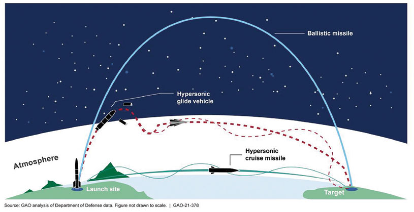
Diagram: U.S. General Accountability Office
BeiDou Enables Hypersonic Flight
In simulation drills using BeiDou, Chinese space scientists flew a hypersonic flight from Jinan, China, to New York over the Arctic Ocean, reports EurAsian Times. BeiDou facilitated contact between the command center on Earth and the hypersonic vehicle as it dodged enemy air defenses. Researchers claim using BeiDou provided a time lag of less than a second. They also claim to have optimized signal transmitters and designed new satellite-jumping methods to overcome communication challenges. China and Russia are the only countries with operational hypersonic weapons — Russia has used its Kinzhal hypersonic missile in the Ukraine war.
Indonesia’s National Research and Innovation Agency (BRIN) and Dr. Soetomo University are cooperating on aerial photo mapping using an unmanned aerial vehicle and GNSS hardware. BRIN’s Ocky Karna Radjasa said he expects that the two parties will extend the opportunity to advance research and innovation as well as bolster the quality of education in Indonesia. The university’s Nur Saidah expects BRIN’s support will increase, stating, “We still have limitation in laboratory facilities, so we seek industry cooperation. Let us hope that, as a result of this cooperation, we can receive help.”
A new navigation system addresses shortcomings of GNSS using cosmic-ray muons. Muometric navigation enables positioning underground, indoors or underwater within a reference coordinate system defined by the 3D positions of multiple detectors, researcher Hiroyuki K. M. Tanaka explains in the June issue of Nature. Tanaka’s work shows the system offers a navigation quality almost equivalent to aboveground GPS-based handheld navigation by determining the distance between the reference frame and the receivers with a precision of 1 to 10 meters.