Fifty years since it was designed and approved by the U.S. Department of Defense (DOD), the GPS is at risk of losing its status as the world’s gold-standard location service, reported The Wall Street Journal.
In a recent paper published by Harvard’s Belfer Center for Science and International Affairs, “China’s BeiDou: New Dimensions of Great Power Competition,” Sarah Sewall, executive vice president for strategic issues at IQT and co-authors Tyler Vandenburg and Kaj Malden outline their finding that China’s version of GPS is part of the country’s longstanding effort to join the technological ranks of leading nations and use its capabilities to achieve geopolitical advantage across the globe.
Sewall’s assessment of BeiDou’s technical superiority received some unexpected support from a government advisory board on GPS, which stated that “GPS’s capabilities are now substantially inferior to those of China’s BeiDou,” and urged the administration to regain U.S. leadership in the field.
The BeiDou constellation is newer and has more satellites than any other system and has more than ten times as many monitoring stations around the world than GPS does. As a result, BeiDou’s accuracy is much better in many places, including the developing world.
Sewall points out that in cases where BeiDou provides the most accurate positioning, navigation, and timing (PNT) data, particularly in the global south, China may be able to influence other nations’ economies, stating that it is one example of “a new form of great power competition that most in the U.S. government don’t recognize.” China is providing superior PNT information to enhance its diplomatic, economic and military power and the United States cannot afford to cede this area of longstanding advantage.
BeiDou being newer and more advanced than other GNSS, makes it easier for China to encourage other nations to use its signals and purchase specialized equipment, especially when equipment purchases are heavily subsidized by the Chinese government, harming the U.S. economy and its status as the leader of GNSS technology.
Recent launch and surveillance fears
On May 16, 2023, China launched its most recent BeiDou satellite to replenish the constellation, bringing its total to 56 satellites, nearly twice as many as the 31 GPS satellites.
The latest BeiDou satellites also feature two-way messaging, a feature that GPS does not have. It is mainly available in China and requires special chips that are not widely available in the consumer market. It enables users to send short messages in areas without ground network cell coverage and can be used for search and rescue operations.
The CNBC report noted the fear that, with its most recent enhancements, the BeiDou system could be used as a surveillance device — as the two-way messaging feature reveals a user’s locations as well as other types of data.
Additionally, with the growing number of applications for cellphones and an increase in autonomous vehicles that use the BeiDou system, more and more user data is being transmitted.
The U.S. military is upgrading GPS with more-modern satellites that are designed to give nonmilitary devices more-precise coordinates in more indoor and hard-to-reach spaces. However, the next-generation GPS service for civilians is not expected to be released for several years.
GPS pioneered the PNT industry by offering civilians a new, free-to-use system. While originally developed for DOD, it turned into a critical global infrastructure that underlies a vast swath of the U.S. economy.
Besides GPS and BeiDou, there are two other global navigation satellite systems (GNSS), Russia’s Glonass and the European Union’s Galileo, as well as regional systems from Japan (QZSS) and India (NavIc).
BeiDou, once a small regional network with clunky receivers and few civilian users, has grown significantly since launching its first two satellites in 2000. It now has more than 30 precision-enhancing monitoring stations and claims to pinpoint users’ locations to within several centimeters, along with offering basic two-way communication capabilities.
Both BeiDou and GPS offer a variety of nonmilitary benefits that expand beyond the systems’ original expectations, from Uber drivers who often rely on a smartphones GNSS data to locate customers to farmers who can use GPS-based applications for farm planning, field mapping, solid sampling and more. GPS has been called “the silent utility” because signals are used in almost every technology, said Dana Goward, president of the Resilient Navigation and Timing Foundation.
Looking forward
GPS guides U.S. missiles, ships and troops through more-secure military frequencies kept separate from its civilian signals. Its past dominance even made rival militaries reliant on the Pentagon-controlled system.
The U.S. military has long planned to upgrade GPS with a fleet of modernized and upgradable satellites that provide more-precise coordinates subject to less interference. The newer satellites broadcast data to civilian users over a new frequency called L5.
The Space Force has 17 L5-equipped satellites in orbit after a series of delays but has yet to reach the 24 live satellites needed to run a reliable system. Some already-built satellites sit in a Colorado warehouse awaiting their turn for a funded launch.
The Space Force said in a statement that GPS continues to set the gold standard in its field.
“While other nations may report improvements in accuracy and equivalent performance in availability, GPS is still the clear leader in integrity and is the only system accepted for international flight use,” a spokeswoman for the branch’s Space Systems Command told The Wall Street Journal.
The phrase “positioning, navigation, and timing” (PNT) — widely used in our industry, including on this magazine’s cover — encapsulates a wide range of applications for global navigation satellite systems (GNSS) and for other technologies that provide some or all the same services. Subsumed under “positioning” is one of the most widespread uses of GNSS, which is data collection to make maps, enable geographic information systems (GIS), and populate the databases that power the many location-based services (LBS) applications on smartphones.
Increasingly, GNSS positioning is also integrated with systems for indoor positioning to enable seamless tracking of people, equipment and products, and with a variety of sensors to monitor their status and environmental conditions.
GNSS positioning and mapping will benefit from the advent of G5 cellular networks, which will vastly increase download speeds, decrease latencies and expand connectivity. While it will transform every industry, 5G’s impact will be especially felt in urban settings and pave the way for tomorrow’s smart cities.
In this month’s cover story, we focus on these aspects of GNSS by presenting three brief case studies:
Golf course irrigation planning and construction, using Trimble Catalyst.
Land surveys to update China’s national GIS, using a CHC Navigation LT700 receiver.
Safety with industrial automation
Industrial automation is an extremely wide area,” said Ludger Boeggering, u-blox senior principal segment manager, EMEA Energy & Automation. “It includes process and production automation, where it is used to automate the production environment. In more remote conditions, where it is less time-critical, it is used to understand what happens in the automation environment. Lastly, it is used to remotely supervise and monitor what is happening in such an environment.”
Nowadays, businesses want to monitor their production environment “all the way down to the production of a single device,” Boeggering said. “That’s the area in which we operate.”
One application of industrial automation on which u-blox is increasingly focusing is the safe, connected worker, which can refer to someone inside a building on a factory floor or someone outside, such as on a construction site. Another one is mobile robotics and collaborative robotics.
“Our customers are in all segments and verticals — including electronics, machine manufacturing, oil and gas, transportation, chemical, food, water, paper and energy,” Boeggering said. “It’s really a broad spectrum of industrial companies that are using these tools and products. We are focused on the leading customers in that area and are working with well-known players in the market.”
5G is an umbrella for different flavors of the technology that includes enhanced mobile broadband and ultra-low latency. “There has been much hype about this,” Boeggering said. “In the beginning, everyone focused on low latency and, potentially, high bandwidth. In reality however, customers realized that it would be too expensive to implement it so as to have both.” This led to the emergence of 5G RedCap, which stands for reduced capability. “It covers a bit of the low latency stuff and a bit of the higher bandwidth stuff, but also makes it more cost effective.”
For many applications, such as video and augmented reality, latency is less important than speed. Then there’s the question of reliability. “Nowadays, reliability and availability are the most important issues,” Boeggering said. “If you have an automation process with very high motion, you definitely need high reliability and low latency.”
Factories can now set up their own environment and combine communication technologies, using low latency and many sensors. “For example, on the campus of a chemical factory you have some critical processes that require reliable connectivity,” Boeggering explained. “There, 5G can provide that. At the same time, there are hundreds of thousands of sensors to be connected. This requires a private network environment that can be controlled.”
“The reason for going wireless is less about being mobile and more about being flexible — such as setting up or re-arranging a production line in a very short time,” Boeggering said. “It normally takes a car manufacturer nine to 12 months to set up a production line for a car. It requires a lot of cables and installations. These guys aim to bring that time down to three months. That means that when they are starting to rebuild a construction area, in the best case, they can make the connectivity for all the communications entirely wireless and just plug the machines into the power.”
Construction sites require a solution that provides a seamless indoor-outdoor location. For example, a construction company may want to know the location of all its tools on a large campus. When they are outside, they can be easily located with GNSS. More often, however, they are inside concrete walls. “Nowadays, we don’t really have a solution that covers that indoor-outdoor area seamlessly,” Boeggering said. “On a construction site, you can’t set up an infrastructure to do that. So, you need one that is already available. There 5G might be able to help.”
u-blox can provide solutions that fit across the communication technologies. “5G is not the only technology that will be used in industrial automation environments,” Boeggering pointed out. “We have the portfolio, starting with GNSS when it comes to location, and, when it comes to short range, wireless, Bluetooth, Wi-Fi, and of course, cellular. We are providing to these OEMs the right components to create the final solution, including positioning and communication services.”
“The customers, who want to know where their equipment is, do not care whether that information is derived using GNSS, Bluetooth, or Wi-Fi,” Boeggering said. “They just want to know in which room it is, on which level, or in which area of their factory. Of course, customers certainly would like centimeter precision. However, the question is whether they want to pay for it. GNSS plays a huge role for location outside and close to windows. However, once you can’t get this data, you need an alternative solution. This can be done in combination with any wireless technology. There are use cases in which Bluetooth might work independently from GNSS, but when it comes to Wi-Fi or cellular 5G, GNSS is definitely helping to get the location. So, we always play a role.”
Irrigating the green
“We’ve always used GPS equipment to map out our clients’ properties across the country,” said Michael Kuhn, owner of Michael Kuhn & Associates Inc., in Birmingham, Michigan, which specializes in irrigation systems for golf courses. “Very rarely do they have an accurate base map of the property. So, instead of going to third parties, we decided 20 years ago to buy our own GPS equipment and map these properties ourselves as a starting point to do our design work for new irrigation systems,” Kuhn said.
The Trimble Catalyst. (Image: Trimble)
Since starting his business, Kuhn is now on his third or fourth generation of Trimble equipment. “Convenience and time are always key factors with me,” he said. “As this equipment has evolved, it’s become more user friendly, and more convenient.”
He spends a lot of time on the road and needed a way to collect data on golf courses and get it to his staff back at the office, so that they could clean it up and get it ready for him as quickly as possible. Before Trimble released Catalyst, he had to go back to his hotel, remote into his office computer and transfer the data from his laptop through some kind of cloud-based device. “Now, with this new Catalyst equipment, it is so much more streamlined, and the price point has been fantastic,” Kuhn said. “Everything’s now going subscription-based anyway. Not just software but hardware as well. That allows me to do a few more things that I couldn’t do before.”
The golf courses around the country with which Kuhn works are constantly doing projects and updating infrastructure. “We end up being the gatekeepers for the overall mapping for our clients’ golf courses for infrastructure,” he said.
Before Trimble released Catalyst, Kuhn recalled, some of his clients spent up to $30,000 for equipment that would collect data sufficiently accurate to incorporate into his mapping.
“When Trimble came out with Catalyst and a subscription-based pricing, depending on what kind of accuracy you need, it was a no brainer. The first group that I thought of was my clients — giving them the ability to get entry-level subscriptions, but still be able to maintain centimeter-grade accuracy because they’re using an hourly subscription instead of paying thousands of dollars a year.”
Kuhn also uses aerial photogrammetry.
“Not that long ago, it was tough to get your hands on ortho-corrected aerial photography that could match up with my base maps,” he recalled. “I would typically go to municipalities. More and more of them have GIS departments now. Often, I could get access to ortho-corrected aerial photography from them, either for free or at a cost. It was accurate, but you would be at the mercy of whenever the county was doing its aerial photography,” Kuhn continued.
Then Kuhn came across Nearmap and began to use their aerial photography. “It wasn’t ortho-rectified at all, but they were flying multiple times a year,” Kuhn said. “It was nice to incorporate it into what we were doing, to make sure that I could see the latest and greatest overhead of whatever property I was looking at.” When Nearmap switched to a subscription-based business model, however, Kuhn did not sign up because the images were not georeferenced. “It’s a lot of work when you must manipulate an aerial and get it to match up to a base map. Then, probably two or three years ago, they started to geo-reference their aerial imagery and we signed up and they’ve been great.”
Right now, Kuhn’s equipment is close to centimeter-grade. “We were the first independent irrigation consulting partners to get this three-dimensional hydraulic modeling software to run our irrigation systems,” he said. “In a three-dimensional model, before we even finalized drawing, we were able to model the systems that we were designing that could tell us what pressure drops were across a 500-acre piece of property three dimensionally.” That required a topo map of the property, which he would get from the relevant county.
Pump stations for golf course irrigation systems pump 2,000 or 3,000 gallons a minute across hundreds of acres, sometimes in the mountains and typically full of steep inclines.
Image: Michael Kuhn & Associates Inc.
“It could be in Colorado or Salt Lake City or in a place flat as a pancake, but it is absolutely critical to still have the ability to run that hydraulic model and have accurate data flow horizontally and vertically,” Kuhn said. “With the data that we have now, I can run an irrigation cycle in multiple different ways and tell the end user what the pressure is in the back left corner of a green within 1/100 psi. It’s invaluable.”
Kuhn supports his clients in many ways. “Since the Trimble Catalyst equipment came out, I’ve recommended to my clients and to contractors that they switch to it. Golf course building contractors have always had good equipment, such as total stations, and this was just another tool that they could have to collect data quickly and easily.”
Additionally, Kuhn pointed out, Catalyst provides a sharing platform. “So, I could create a team for a golf course and then they could get the same equipment and create a project and we can make each other part of each other’s team. So, they have access to all the data that they collect and all the data that I collect, to the extent that I give them permission to use them. That’s critical. I mean, sharing data with contractors is another component that we really didn’t have before.”
Collecting data for GIS
Image: CHC Navigation
CHC Navigation is assisting China’s Ministry of Natural Resources to conduct its third national land survey. The ministry regularly organizes nationwide land surveys to update the country’s national GIS database, including spatial and attribute information. In addition, surveyors are required to take multiple high-resolution images of each area in different directions to provide verification information. As the project progresses, all data will be uploaded to a server via a cellular (4G) connection. In terms of accuracy, this project requires an expected accuracy in the order of one meter.
For this project, China’s Ministry of Natural Resources used the CHCNAV LT700 rugged Android tablet. Featuring an 8-in screen viewable in direct sunshine and in high-bright areas, the LT700 is well suited to display GIS data tables, complex vector and raster maps or high-resolution pictures. Unlike consumer tablets, the L700’s IP67 industrial design withstands daily use in harsh environments and conditions. Protected from dust, rain, extreme temperatures and accidental drops from 1.2 m, the LT700 is an advanced solution for such applications as forestry, utilities, asset management or environmental studies. Bearing the Google Mobile Service (GMS) certification, the LT700 runs seamlessly the most common professional data collection applications available from the Google Play store.
The main challenges associated with using data collectors in the field are related to the natural environment and the need to ensure reliable georeferencing accuracy down to the meter. Surveyors and GIS technicians work in a variety of environments, including cities, mountains, plateaus and forests. They can work for up to eight hours in rain, snow and extreme temperatures. As a result, their equipment must be well protected from shocks and bad weather, with long battery life and a high-brightness display.
A GIS specialist collecting the locations of assets using an LT700H RTK Android tablet by CHC Navigation, which has centimeter accuracy. (Image: CHC Navigation)
With the LT700 rugged tablet, surveyors can focus on collecting data in the field without interruptions or wasted time, and without worrying about weather conditions. The device delivers metric accuracy with SBAS support, which greatly improves the reliability of georeferencing and the consistency of collected data, regardless of the operator. Its lightweight construction and convenient size make it easy to transport on foot, especially when working in mountainous terrain or crossing rivers. The LT700’s 4G connectivity has made it possible to continuously update data and organize work sessions based on updated data.
Image: Navy Petty Officer 1st Class Devin M. Langer
The U.S. Department of Defense has called for thousands of UAVs to be built as a part of its Replicator initiative that aims to hasten military innovation to “leverage platforms that are small, smart, cheap and many,” said Deputy Defense Secretary Kathleen Hicks in a recent speech. This was cited in a Wall Street Journal editorial published on Sept. 13.
The United States plans to build thousands of UAVs over a 24-month period to counter China and the current military threat against U.S. forces in the Pacific Ocean. The UAV swarms could help the United States jam or distract enemy radars and surface-to-air missiles to stop China from pushing U.S. forces out of the Pacific.
The Wall Street Journal article stated that this idea by the Pentagon is not a real substitute for a bigger navy. While the Pentagon’s idea of UAV swarms for reconnaissance in the Pacific is technologically innovative, the article stated that the United States will still need technology breakthroughs and plentiful stocks of materials ranging from aircraft to munitions.
Furthermore, Deputy Hicks said that the Replicator initiative is not asking for new money in the next fiscal year budget, citing “not all problems need new money; we are problem-solvers, and we intend to self-solve,” reported the Wall Street Journal.
A new swarm of UAVs will give significant support to the U.S. military to counter China. However, the Pentagon’s quick plan for an unmanned technological “revolution” will need more investment to compensate for the failures that will inevitably accompany the new technology, the editorial argued, and to build “two Virginia-class submarines a year and fielding thousands of long-range weapons so U.S. forces don’t run out of their best firepower after a week in the Taiwan Strait.”.
Two recent announcements showed China’s progress establishing its national “High-Precision Ground-based Timing System.” Some verbiage in the most recent announcement could indicate that the system is nearing completion.
The timing system is designed to support a vast array of scientific and technological applications as well as provide services when space-based signals are not available.
According to some Western observers, it is another example of China’s increasing lead over the United States in positioning, navigation, and timing (PNT) technology.
Completion of the terrestrial system could have even more troubling implications for the United States.
Recent Announcements
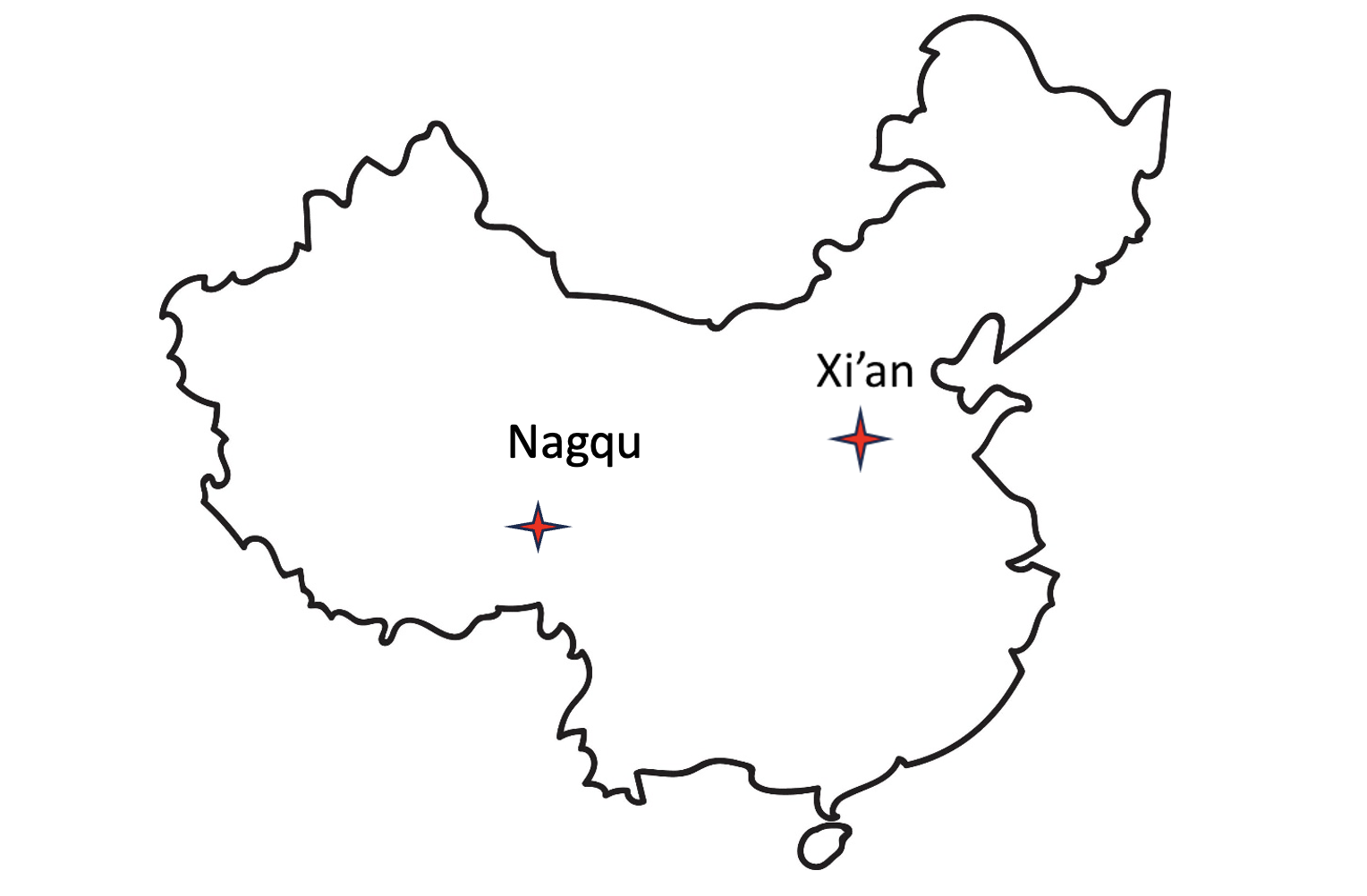
On May 21 this year, a government affairs article in Shaanxi’s “The Paper” announced accelerated construction in Xi’an of a science center. Its centerpiece will be the country’s High-precision Ground-based Timing System. It is not entirely clear from the article whether this site will be the engineering and administrative headquarters for the system, or one of several “timing stations.”
The article also says the national system will be the largest in the world — with more than 20,000 kilometers of optical fiber and 295 time and frequency transmission sites — and will integrate space- and ground-based signals.
The network, according to the article, will supplement and improve the new eLoran (sometimes mistranslated by software as “Roland”) system in the western portion of the country. It will also support legacy eLoran “long-wave” signals in the east ensuring that the entire nation is well served.
Graphic from 2014 Chinese Academy of Sciences paper on Laron showing projected coverage in the western part of the country. Subsequent papers and announcements have indicated that western part of the network is complete or soon will be. (Image: Chinese Academy of Sciences)
Accuracy for the system’s fiber-optic transmissions is claimed to be less than 100 pico-seconds, with differential eLoran at less than 100 nanoseconds.
Construction recently announced in Xi’an and Nagqu as part of China’s High-precision Ground-based Timing System.
A much shorter press release was issued on June 8, announcing groundbreaking for a “timing station” in Nagqu on the Tibetan plateau in China’s west. The announcement said that, once the station was complete, China will “…realize national soil coverage of long-wave [eLoran] timing signals…”
Expansion of its eLoran and fiber infrastructure to serve the entire nation gives China what some have called the “PNT resilience triad” — signals from space, from terrestrial broadcast, and over fiber. The three sources of delivery are sufficiently different that an accidental or malicious disruption of one is highly unlikely to impact the other ones. Users accessing all three should experience minimal to no impact.
Both the May and June announcements said that finishing the timing project will benefit China’s national economy and national security.
Timing is essential tech infrastructure. More precise and robust timing enables improvements to current applications and the creation of new ones. For example, better timing can enable greater spectrum efficiency with more throughput on existing frequency bands. Highly precise fiber-based timing could also support using 5G telecommunications networks for hyper-precise positioning in autonomy corridors serving self-driving vehicles, UAVs, and other systems.
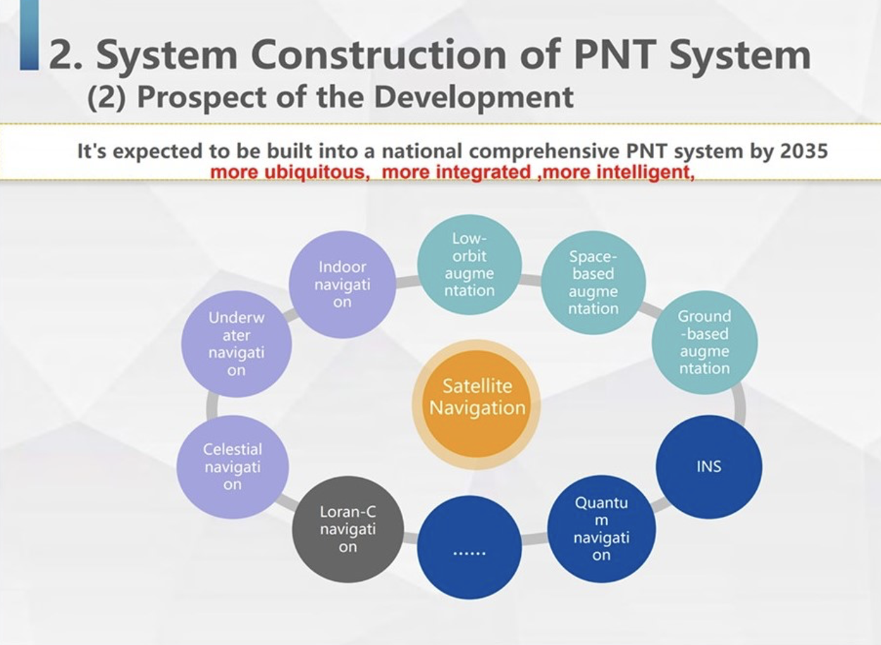
China’s ground-based timing system is part of a larger plan by its National Timing Service Center for a system of systems approach to PNT. Described as a “comprehensive approach” at the Standford PNT Symposium in 2019, the architecture has satellite-based navigation at its heart and includes a wide variety of other capabilities.
Graphic showing China’s plan for multiple, mutually supporting, diverse methods of positioning, navigation, and timing service and data. (Presentation by China’s National Time Service Center at 2019 Standford PNT Symposium)
Some observers trace China’s national PNT efforts to an incident in 1996 during the Third Taiwan Strait Crisis. Chinese forces fired three missiles toward a point in the sea offshore of Tiawan’s Kee Lung naval base. Two of the missiles were lost. According to the People’s Liberation Army this was because the United States denied or altered GPS signals that the missiles were using for guidance.
Known by China’s military as “The Unforgettable Humiliation” the incident sparked decades of effort to ensure China would never again be dependent upon another nation or space for PNT. The BeiDou global navigation satellite system and the High-precision Gound-based Timing System are the two most noteworthy accomplishments in this regard.
Implications for the United States
China’s ever-increasing lead in essential PNT technology and infrastructure is of great concern to many in the United States.
China’s global navigation satellite system, Bei Dou, is newer and, according to a presidential advisory board, substantially superior to GPS in many ways. Using it as an instrument of “soft power,” China is offering other nations BeiDou signals, along with discounted user and support equipment, as part of its Belt and Road, and Digital Silk Road initiatives. Where successful, these efforts erode both GPS usage and U.S. influence.
Of greater concern to many are the “hard power” implications of China’s PNT dominance.
While China has and continues to develop multiple and resilient sources of PNT, in the United States “GPS is still a single point of failure,” according to a member of the National Security Council.
As a result, if China were to interfere with GPS in some way, a U.S. response in-kind against BeiDou would have much less impact. This strategic asymmetry has been described by former CIA senior analyst George Beebe as “an open invitation” for mischief or attack. One that could easily lead to an escalating series of responses ending in an armed conflict no one wants.
At a more tactical level, China’s eLoran system extends 1,000 miles offshore covering Taiwan, the Strait, and all approaches. In a conflict to capture the island and make it subject to the Communist regime, China could block all signals from space while preserving its forces’ ability to maneuver and communicate. Already at a disadvantage having to deploy far from their support bases, this would further hamper U.S., Japanese, and other forces hoping to help Taiwan maintain its independence.
The U.S. Department of Defense boasts it can operate well in GPS-denied environments and says it is also working on alternative means of navigation for deployed forces.
This begs the strategic question, though, of whether the United States would be willing to come to the aid of Taiwan or another ally if the homeland were threatened with a prolonged and crippling disruption of GPS services.
Prior to Russia’s invasion of Ukraine, the Kremlin destroyed a defunct satellite and boasted it would shoot down all 32 GPS satellites and “blind NATO” if the alliance intervened. Many observers have wondered whether that has played into subsequent U.S. and NATO policy toward the conflict.
Unfortunately, little has been done to eliminate the possibility of a belligerent adversary holding the U.S. homeland hostage through GPS.
For two decades narrow government and industry interests in GPS production have successfully opposed any effort they see as possibly “competing” for space in limited budgets. Appeals that such projects would increase system security by “taking the bullseye off” GPS satellites and signals have been to no avail.
However, this may be changing. Several years ago the National Guard began development of a national timing architecture and network, called NITRO. The project supports the Guard’s own requirements to be able to operate without GPS and to aid state first responders. It is already in use in 7 states.
The future of NITRO is unclear, though, as the Department of Defense sees it as a civil defense rather than a national defense project and is no longer supporting it in the budget. Yet, the National Guard’s funding flows through defense appropriations.
As of this writing, the National Guard and NITRO remain stuck in a bureaucratic and budgetary no-man’s land with no clear path forward.
Ground antenna at Schriever Air Force Base, home of the 50th Space Wing. (Photo: Raytheon)
GPS ground stations that are contracted by Raytheon Technologies to replace the current ground stations are more than seven years behind schedule and lawmakers are not happy, reported Defense One. This delay has caused the U.S. Department of Defense (DOD) to go over its yearly budget and has sparked discussions as to future budget allocations for the U.S. Space Force (USSF) to continue to control and enhance the GPS constellation.
The USSF has been working to replace the current GPS ground stations with the GPS Next Generation Operational Control Segment (OCX) program since 2016. The operation was first delayed when the COVID-19 pandemic swept the world.
The additional delay was caused by efforts to replace IBM as the OCX hardware supplier after IBM sold its server product line to the Chinese company, Lenovo. The Pentagon believed the OCX program would be at a high risk for Chinese hacking after the sale to Lenovo, and in response, the contract with Raytheon was modified to replace the hardware with HP in 2020.
All of the delays have come at a cost, as the replacement of ground control stations has increased from $4 billion to $7 billion — a 73% increase over the original estimate — which was reported by a Government Accountability Office report in June.
Lawmakers wrote in the 2024 DOD appropriations bill, “[t]he fiscal year 2024 President’s budget request for the Space Force is $30,197,634,000, an increase of $3,907,806,000 or 15[%] over last year’s enacted level, continuing a trend of double digit growth over the past several years… [h]owever, despite these significant increases, the budget request continues to include serious shortfalls and disconnects.”
The USSF operates 32 GPS satellites, including six of the expected 10 next-generation GPS III satellites. However, some of the new satellites’ capabilities, including increased jamming resistance, can only be used once OCX comes online.
The lawmakers shared their displeasure with the OCX program delay, “[t]his is unacceptable and demands senior leader attention to ensure the program has the appropriate resources to complete OCX development and deliver the capability as soon as possible. The Committee remains concerned by other poor performing programs including Space Command and Control, Family of Advanced Beyond-line-of-site Terminals, Military GPS User Equipment Increment 1, and Enterprise Ground Services.”
China’s BeiDou GNSS is newer, has more features, is more accurate, and has more satellites in the skies of more nations than the venerable U.S. GPS, according to Sarah Sewall, Executive Vice President for Strategic Issues at IQT.
Image: BeiDou program
More than that, it is one example of “a new form of great power competition that most in the U.S. government don’t recognize,” she said. China is providing superior precision, navigation, and timing information to enhance its diplomatic, economic and military power and the United States cannot afford to cede this area of longstanding advantage.
In a recent paper published by Harvard’s Belfer Center for Science and International Affairs, “China’s BeiDou: New Dimensions of Great Power Competition,” Sewall and co-authors Tyler Vandenburg and Kaj Malden outline their finding that China’s version of GPS is part of a longstanding effort to join the technological ranks of leading nations and leverage its capabilities to achieve geopolitical advantage in many areas.
“First, the global reach of BeiDou ensures that the Peoples’ Liberation Army is no longer dependent on another nation’s satnav. China’s economy — and those of other nations relying on BeiDou — can continue to function even if GPS is degraded or denied,” Sewall stated. “This may increase Beijing’s incentives to attack other national satellite capabilities.”
“BeiDou is also an economic driver for the Chinese economy and innovation. The output of China’s commercial space and navigation services industry has increased by tens of billions in the last decade, and new applications such as precision agriculture and self-driving cars show no sign of slowing,” Sewall continued.
The focus of Sewall’s paper, though, is the way BeiDou supports China’s Belt and Road and Digital Silk Road initiatives to gain influence and leverage around the world. She points out that in cases where BeiDou provides the most accurate positioning, navigation, and timing (PNT) data, particularly in the global south, China may be able to hold much of another nation’s economy hostage.
The BeiDou constellation has more satellites than GPS or any other system. It also has more than ten times the monitoring stations in other countries than have been deployed for GPS. As a result, in many places, particularly in the developing world, BeiDou’s accuracy is much better.
Her assessment of BeiDou’s technical superiority received some unexpected support recently from a government advisory board on GPS. It reported that “GPS’s capabilities are now substantially inferior to those of China’s BeiDou,” and urged the administration to regain U.S. leadership in the field.
Being newer and more advanced makes it easier for China to encourage other nations to use BeiDou signals and purchase specialized equipment, especially when equipment purchases are heavily subsidized by the Chinese government.
This is important because systems such as GPS and BeiDou provide more than just directions to the nearest coffee shop. Their precise PNT signals are used for everything from synchronizing cellphone networks and industrial machine controls, to time stamping financial transactions, and coordinating electrical grids. GPS has been called “the silent utility” because signals are used in almost every technology.
“It is very difficult for government leaders in the developing world to turn down discounted infrastructure and opportunities for economic development,” Sewall said. “Even if they know that tying that infrastructure to Chinese signals may give the CCP [Chinese Communist Party] a future on/off switch to their economies.”
The West and the United States in particular, faces challenges confronting China’s efforts with BeiDou, according to Sewall.
“Many in government equate national power with military power, but that’s a narrow and insufficient formulation, particularly in the 21st century,” Sewall said. “American officials under appreciate China’s efforts to create commercial technology dependencies abroad. The United States has left a vacuum in the developing world that our industry is seemingly unable to fill in the face of competition from Chinese firms that are heavily supported by their government.”
Sewall describes a Chinese “tech stack” being exported that include BeiDou services as part of Belt and Road and Digital Silk Road. It is comprised of a hierarchy of equipment that includes network cables, servers, and cell phones.
“We don’t really have a democratic approach to help foreign nations make meaningful technology choices. We risk ceding global infrastructure to China if we fail to help Western firms offer their own integrated products and services to the developing world,” she said.
If we recognized this new form of great power competition, America could easily leap frog China in areas such as satellite navigation, said Patrick Diamond, a member of the President’s Advisory Board on GPS.
“We could provide higher accuracy GPS and make signals much more secure though internet delivered authentication,” Diamond said. “We could offer complementary terrestrial systems to GPS that would give other nations their own sovereign source of precise time and location while at the same time cooperating with our signals from space.”
“Competing effectively with China in the coming decades will require Americans to think more holistically,” Sewall said, “from realizing that GPS is not just about the military and space, to understanding that national power is more than the ability to prosecute war.”
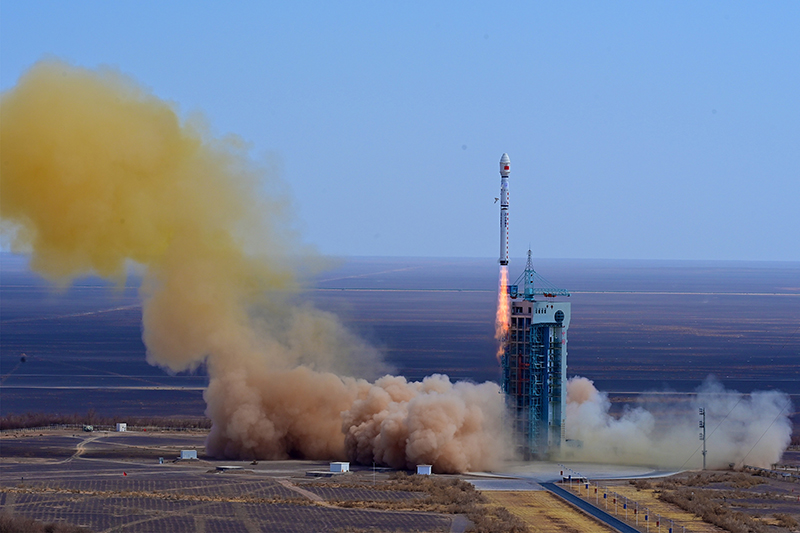
On May 16, China launched a BeiDou satellite to replenish the constellation, reported Space News. This brings the constellation total to 56 satellites.
This backup satellite was aboard a Long March 3B rocket, which launched from the Xichang Satellite Launch Center in southwest China at 10:49 p.m. Eastern Time. The satellite aims to improve BeiDou’s stability, positioning precision and overall health.
In addition to launching the BeiDou satellite, China also launched satellites to study Earth and synthetic aperture radar test satellites (SAR) for disaster prevention.
On May 21, the Macau Science Satellite 1A and 1B launched on a Long March 2C rocket from the Jiuquan Satellite Launch Center at 4 a.m. Eastern Time. This satellite was designed to study the Earth’s magnetic field.
Also, on May 21, aboard the same rocket was the Luojia-2 (01), a Ka-band synthetic aperture radar test satellite for Wuhan University. The Luojia-2 (01) will test signal enhancement and integration of remote sensing imaging, meteorological detection and more.
The China Aerospace Science and Technology Corporation has planned more than 60 launches this year and has already completed 20 thus far.
“Seen & Heard” is a monthly feature of GPS World magazine, traveling the world to capture interesting and unusual news stories involving the GNSS/PNT industry.
Image: Apple
Apple Products Meet Accuracy with GPS
Apple launched the Ultra Watch, which contains a dual-frequency GPS antenna that can receive L5 signals, as well as the iPhone 14, which features a dual-band GPS receiver combining the L1 and L5 signals. The company is also harnessing signals from more than 70 satellites to boost the accuracy of its services such as SOS alerts and alerting emergency responders, per The National News. The dual-frequency abilities of the new products provide accurate location for calculating distance, pace and routes. The L5 signals also are a critical component of Apple’s health and safety features, providing more accuracy than in previous products.
Wildlife researchers in Key Largo, Florida, accidently discovered a way to locate and eradicate invasive Burmese pythons, per WFLA News Channel 8. The team of researchers were observing racoons and possums that were fitted with tracking collars to note their behavior. After months of observation, a possum collar sent a mortality signal due to lack of movement. To the researchers’ surprise, the collar then started moving again. They later discovered the possum had been eaten by a python. While this was not the intent of the team’s research, they proved this could be an effective way to lower the increasing population of the invasive python species.
Scientist Liu Shaochuang and his team have used satellite remote-sensing technology to study and track wild camels. Shaochuang studies the interrelationship between endangered animals and their environments, which may help protect the species against climate change. To track a camel, Shaochuang attaches a GNSS-enabled collar, which transmits the camel’s location every day. The short message function is provided by China’s BeiDou satellite system, which transmits and receives signals in real time. Based on the data, Shaochuang and his team can observe migratory paths, living environments and possible threats.
Image: Screenshot of CNN video
Former South Carolina Attorney Convicted with Location Data
On March 3, Alex Murdaugh was convicted of killing his son Paul Murdaugh and wife Maggie Murdaugh. With limited evidence, the prosecution used a phone video and vehicle navigation data to prove Alex’s guilt. During the trial, Alex claimed he was visiting his mother during the time the murders took place. However, General Motors OnStar data accessed by investigators from his Chevrolet Suburban contradicted the alibi, putting Alex at the scene of the crime during the time of the murders. Plus, in a smartphone video taken by Paul that night, Alex’s voice could be heard, placing him at the scene.
A couple of stories about unmanned air vehicles in the war in Ukraine and a response to the recent Open Letter by the “Future of Life Institute” with more than 200,000 signatures on advanced AI, which urged a six-month moratorium to allow the development of seemingly much needed AI regulations.
The war in Ukraine
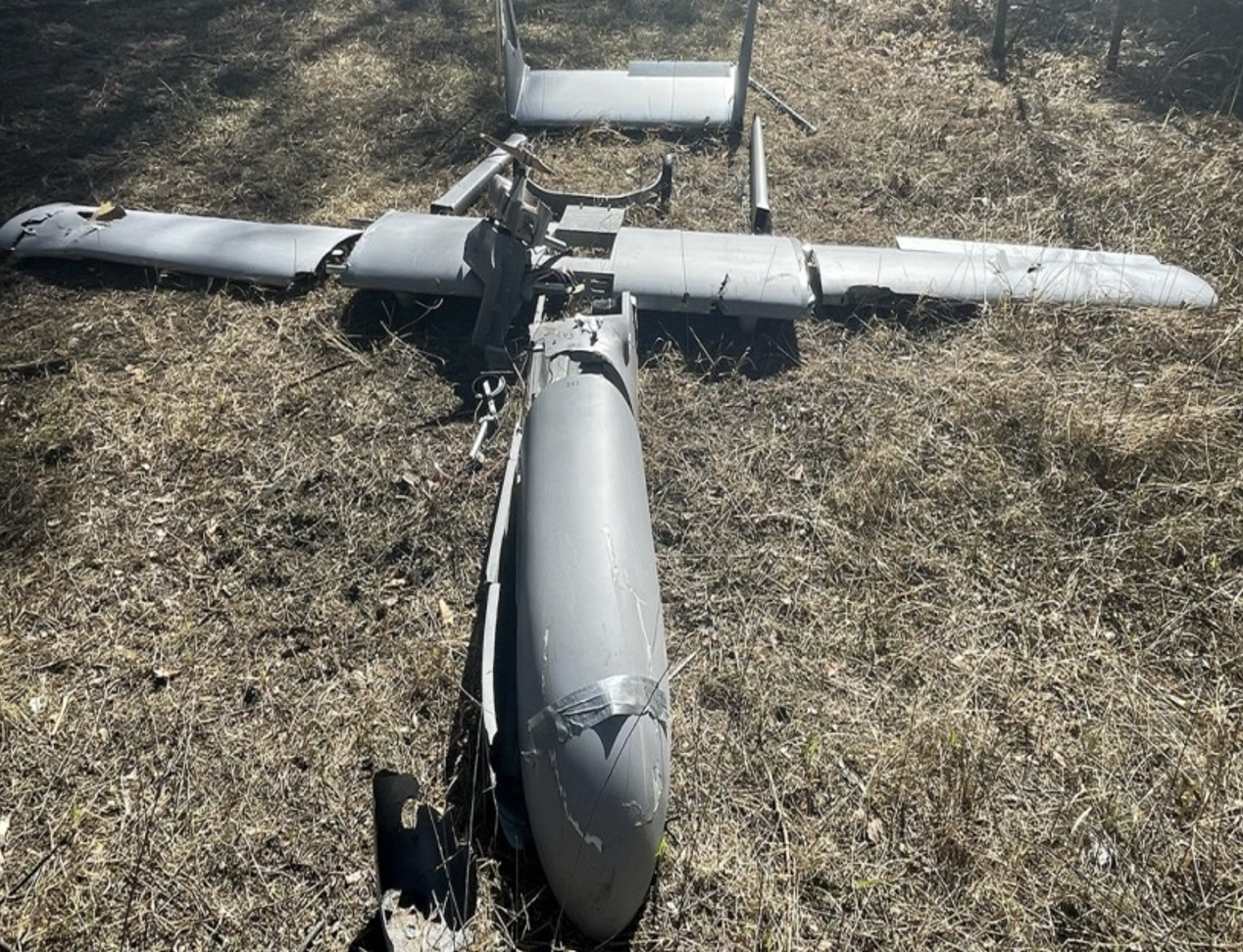
It has been reported that Ukrainian forces were operating the commercially available Chinese Mugin 5 UAV, presumably for surveillance of Russian forces inside Russian-occupied territory. The Mugin 5 can be bought commercially for $10-15,000 and is manufactured by Mugin, which is based in the port city of Xiamen, on China’s eastern coast. In a previous statement posted on the company’s website on March 2, Mugin Limited said that it “condemns” the use of its products during warfare and that it ceased selling products to Russia or Ukraine at the start of the war. However, Russian forces claimed in January 2023 that it had actually shot down one of these Chinese-made UAVs being flown by Ukrainian forces over their territory.
Then, just this week, Ukrainian forces apparently were able to track a low level, slow-moving air vehicle coming at them from Russian occupied territory. After some time, they were able to intercept the UAV, which carried a flashing navigation light, from the ground, and were able to bring it down using small arms. The remains of the crashed UAV were found in a clearing in the forest; a single 44 lb bomb was removed from the wreckage and safely exploded by the Ukrainian team.
Weaponized Mugin 5 following crash in Ukraine forest. (Image: Screenshot from video from Kanal13 Youtube)
Somewhat worse for wear, the Mugin 5 UAV appears to have been held together in places by duct tape and other patches. Is it possible that having shot down a Ukrainian surveillance UAV the Russians recovered these remains and crudely restored the unit to flying and navigating capability, then sent it back to Ukraine owners carrying a bomb? Anything is possible in this conflict.
Staying with this conflict and the use of UAVs by both sides, its seems that Australia has come up with a low-cost surveillance UAV that is virtually undetectable and it’s proving quite popular with the Ukrainians. Most defensive detection involves some form of radar scanning, which relies on radar returns bouncing off a flying target. The Australian company SYPAC in Melbourne has developed the Corvo Precision Payload Delivery System (PPDS). It is a wax-coated cardboard UAV, held together with elastic bands and glue, but carrying sophisticated guidance and control electronics.
(Image: Screenshot of video posted by 7 News Australia)
SYPAQ has developed the CORVO UAV under an AU $1.1 m government contract with the objective of creating a low-cost, disposable UAV to deliver urgent needs — such as medical supplies or to resupply small arms ammunition to the Australian military. CORVO is autonomous once launched, using GNSS guidance, or dead reckoning if GNSS signal is lost or jammed. Apparently, hundreds of these disposable UAVs have already been shipped to Ukraine.
While a surveillance role was originally envisaged in Ukraine, it is reported that, “They have been very good at inflicting lots of damage on the enemy,” according to Ukraine’s ambassador to Australia. So, CORVO UAVs may well have already been weaponized.
Open Letter on AI development
Following a recent open letter supported by Elon Musk and Steve Wozniak that proposes a six-month halt on advanced AI development, I was recently approached on behalf of Professor Ioannis Pitas, director of the Artificial Intelligence and Information Analysis (AIIA) lab at the Aristotle University of Thessaloniki (AUTH) and management board chair of the AI Doctoral Academy (AIDA) with somewhat different views.
In order to further the on-going discussion, I thought it would be appropriate to give some space to an alternate view on AI development. So here are some paraphrased comments approved by Pitas:
Could AI research be stopped even for a short time? It is doubtful. Further AI progress is necessary for us to transition from an information society to a knowledge society.
Maybe we have reached the limits of AI research carried out primarily by Big Tech, which appears to treat powerful AI systems as black boxes whose functionality may be poorly understood.
It seems that the open letter reflects welcome and genuine concerns on social and financial risk management. Are expensive lawsuits in an unregulated and unlegislated environment inevitable as a consequence of ill-advised AI pronouncements?
However, it is doubtful whether the proposal for a six-month ban on large-scale experiments is the solution. It’s impractical for competitive commercial and geopolitical reasons, with very few benefits.
Of course, AI research can and should become more open, democratic and scientific.
Here are a number of suggested options:
Should elected parliaments and governments make the important decisions on AI rather than corporations or individual scientists?
Every effort should be made to facilitate the positive aspects of AI social and financial progress and to minimize any negative aspects.
The positive impact of AI systems can greatly outweigh their negative aspects if proper regulatory measures are taken.
It is possible that the biggest threat is that AI systems could deceive too many people who have little related knowledge. This can be extremely dangerous.
We should counter the big threat coming from the use of AI in illegal activities — cheating on university exams is a rather benign use — while the possibility of criminal exploitation may be very much worse.
The impact of AI on labor and markets will be very positive in the medium to long term.
AI systems should be required by international law to be a) registered in an ‘AI global register’, and b) users should be notified when they converse with or use the results of an AI system.
As AI systems have a huge impact on society, and in order to maximize their benefit and socio-economic progress, it is recommended that: o advanced key AI system technologies should become mostly open o AI-related data should be at least partially open.
However, strong financial compensation schemes should be established now for AI technology developers to compensate them for any component that becomes open source.
Well, this is a bit of a departure from our nominal UAV/AI report, but there does seem to be a growing number of voices calling for some form of AI regulation and more extensive discussion might well help this movement come to a conclusion. And it would seem that the U.S. administration is listening, as the U.S. Commerce Department has announced that it is seeking inputs from interested parties for methods to test the safety of AI systems — to ensure that they are “legal, effective, ethical, safe and otherwise trustworthy.” In order to enforce these standards, the department is investigating whether audits and inspections to certify AI systems should be required before their release on the unsuspecting public.
The U.S. Commerce Department is apparently not alone in these concerns, as China is also looking to ensure that systems such as Alibaba Cloud’s Tongyi Qianwen, a competitor to OpenAI’s ChatGPT, are socially beneficial. Meanwhile, following the release of ChatGPT and similar products from Microsoft and Google, awareness has grown of the capabilities of the latest AI tools that generate human-like text passages, and even new images and video. The UK Department for Science, Innovation and Technology and the Office for Artificial Intelligence on the other hand, seem to be looking for an approach to regulation that will not restrict AI innovation.
China will use the BeiDou satellite-based augmentation system (BDSBAS) to provide positioning services in railway surveys and construction, reported the China Railway Siyuan Survey and Design Group and Xinhua Net.
Four satellite-based and 12 ground-based observation stations will be placed along the Wufeng-Enshi railway section located in the Hubei Province in central China.
The BDSBAS and the BeiDou ground-based augmentation system aim to further enhance railway survey efficiency.
Some airlines and military aircraft, including the Australian commercial airline Qantas, are receiving radio interference and GPS jamming from alleged Chinese warships in the Asia Pacific, report Australia Aviation and The Guardian.
The International Federation of Air Line Pilots’ Associations (IFALPA) released a statement acknowledging the reports of interference and recommended that pilots carry on, not respond to the warships and report all incidents to air traffic control.
“IFALPA has been made aware of some airlines and military aircraft being called over 121.50 or 123.45 by military warships in the Pacific region, notably South China Sea, Philippine Sea, East of Indian Ocean. In some cases, the flights were provided vectors to avoid the airspace over the warship. We have reason to believe there may be interferences to GNSS and RADALT as well,” the statement noted.
Further recommendations from IFALPA include notifying company dispatchers of the attempted contact and completing an ASAP report or other company safety report for non-ATC communication or GNSS interference.