The company tested Driver 2.0, a Level 4 production-ready autonomous driving solution
New video highlights navigating heavy traffic safely and efficiently
Photo: DeepRoute.ai
DeepRoute.ai, an international autonomous driving technology company, has announced the results of its latest fully driverless test of its Driver 2.0 Level 4 production-ready autonomous driving solution.
DeepRoute.ai released a video exhibiting a driverless vehicle retrofitted with the solution on Central Business District roads in Shenzhen, demonstrating its advanced capacity in complex and challenging traffic environments. It was the first legal driverless test in China — Shenzhen unveiled China’s first regulation on intelligent connected vehicles on July 6.
The fully driverless vehicle drove just under 14 miles in one hour, navigating through significant traffic and narrow lanes safely and efficiently. The vehicle:
intelligently maneuvered around double-parked cars and counterflow e-scooters and pedestrians
negotiated with oncoming vehicles to calculate the right timing and trajectory to pass busy intersections
conducted multiple lane changes and unprotected left turns.
“The recent legislation permitting driverless robotaxis in Shenzhen is the first of its kind, a major milestone in advancing autonomous driving technology to wider and faster adoption,” said Maxwell Zhou, CEO of DeepRoute.ai. “As we advance our mission for commercial deployment of autonomous driving vehicles, we will collaborate with automakers to refine our L4 solution to make it as safe and efficient as possible.”
DeepRoute.ai has made significant improvements to achieve driverless capability, with both software and hardware meeting auto-grade standards. The safety mechanism was also upgraded to guarantee driverless safety on the road. In the case of long tail scenarios, the system will alert the remote monitoring center to intervene or take other safety measures.
The Driver 2.0 System
Driver 2.0 includes five solid-state lidar units, eight cameras and other sensors, and a computing platform integrated with its proprietary inference engine. The perception algorithm with sensor fusion can achieve precise object detection up to nearly 220 yards. The planning and control algorithm based on game theory can choose optimal routes and make decisions based on real-time situations when negotiating with oncoming vehicles and other road agents.
With its deep learning approach, the inference engine optimizes compute resources, allowing the algorithm to run on its low-cost and power-efficient computing platform effectively and stably. As a result, Driver 2.0 can be priced at $3,000 for automakers in mass production and the algorithm can work with 2 to 5 solid-state lidars for automakers’ customization needs.
The latest legal and regulatory framework is aligned with autonomous-driving industry developments and is considered the prelude to mass production and commercialization of autonomous-driving vehicles. DeepRoute.ai is working with automakers to mass produce consumer vehicles integrated with Driver 2.0, expected to be available for consumer purchase in 2025. It is also being integrated into robotaxi operations.
Hackers in China managed to gain entry into satellite operators, defense contractors and telecommunications companies in the United States and southeast Asia, reports Reuters.
Reuters spoke with security researchers at Symantec Corp. ahead of public release of a security report. The hackers have been removed from infected systems.
The hackers breached computers that controlled the satellites, including access to orbital systems, Symantec said. GNSS, communication and other data transmissions rely on specifically situated satellites.
Symantec said it has already shared technical information about the hack with the U.S. Federal Bureau of Investigation and Department of Homeland Security.
A “BeiDou positioning system for subways” began construction March 20 on the Beijing subway capital airport express line. The project will cover a 30-kilometer-long section of the express line, including five stations.
To provide positioning, the BeiDou Navigation Satellite System (BDS) will be combined with 5G for indoor positioning or in areas where the satellite signals are blocked.
The system will improve the positioning accuracy in subways to less than two meters, making it available for vehicle dispatching, passenger transport organization and emergency response. In addition, it allows passengers to use their phones to navigate and position in complex environments in subway stations through three-dimensional navigation.
“We will combine indoor and outdoor positioning in subways, that is, Beidou and its augmented reality technology will be used outdoors to achieve high-accuracy positioning, and indoor positioning technology integrated with 5G will be used to allow users to receive indoor positioning signals,” said Lin Luzhou, vice president of the GNSS and LBS Association of China.
The project is the largest indoor space navigation and positioning system in China, according to ECSN.com, and is expected to be finished within this year.
ComNav Technology Ltd. is providing GNSS technology to Africa for projects in land mapping, continuously operating reference station (CORS) construction, precision agriculture and other fields, according to a Feb. 11 article in People’s Daily, the largest newspaper in China.
Every day, thousands of users in Africa are using GNSS products, the newspaper stated, highlighting specifically the use of China’s BeiDou satellite navigation system. For instance, CORS using ComNav GNSS/BeiDou receivers have been built in 11 sub-Saharan African countries, including Kenya and Uganda.
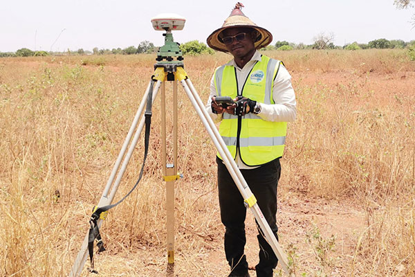
Uganda. To meet the demand for high-precision GNSS, the government of Uganda purchased ComNav’s real-time kinematic (RTK) receivers to build its own CORS. Thirty stations have been built so far, creating the most advanced CORS network in East Africa. Its high-precision spatial and temporal information supports land mapping, mining, vehicle management and meteorological monitoring, among other industries.
In 2015, Mulindwa David, chairman of the Uganda Surveying Association, and others visited the Shanghai headquarters of ComNav to learn about its high-precision products and technologies. After training, David and others mastered basic RTK operation and learned simple maintenance.
David used to carry heavy optical equipment every day, but now he only needs to hold a BeiDou receiver to process the relevant data, which has greatly improved his work efficiency and accuracy. “It took at least three days to survey a dozen kilometers of road with optical equipment,” he said. “With BeiDou high-precision receivers, only 10 hours is enough.”
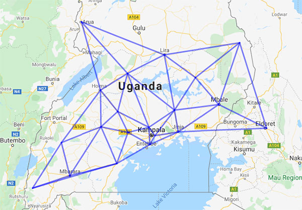
The Uganda CORS network. (Image: ComNav)
Burkina Faso. In response to the COVID-19 outbreak, the Burkina Faso government decided to build a hospital for infectious diseases. In April 2021, it used ComNav GNSS high-precision technology to provide survey data for the hospital’s construction. The land security and topographic surveying tasks were completed in six days, half the time scheduled, said Augustin Bamouni, secretary-general of the country’s national surveying association.
A surveyor in Burkina-Faso surveys the site of a new hospital for infectious diseases. (Photo: ComNav)
Tunisia. The China-Arab BeiDou/GNSS Center is located in the Ghazara Science Park in northern Tunis, the capital of Tunisia. Inaugurated in 2018, it is China’s first overseas BeiDou center, providing satellite navigation training, test evaluation and technical research for African and Arab countries. On average, the center receives real-time data from more than 12 BeiDou satellites at once.
The center will help Tunisia and other African countries train professionals in GNSS technology to support development of the digital economy, according to Amiri Khalil, state secretary in charge of scientific research at Tunisia’s Ministry of Higher Education.
China-Arab BeiDou/GNSS Center is in Tunis, Tunisia. (Photo: ComNav)
China-Africa Forum. The first China-Africa BeiDou System Cooperation Forum was held in November 2021 in Beijing to encourage cooperation between China and Africa and promote use of BeiDou. Four cases from ComNav Technology were described in the forum’s document citing application scenarios of BeiDou in Africa.
ComNav Technology has deepened its cooperation with Africa since China’s Belt and Road Initiative began in 2013. Besides providing products and technologies, ComNav arranged employees to go abroad to provide technical support, traveling to Cameroon, Nigeria, Mali, Zambia, and other African countries. Despite the pandemic, ComNav continues to provide professional service and training both in person and remotely.
TerraStar X corrections technology enables lane-level accuracy with under one-minute convergence for consumer and automotive-grade GNSS receivers
Hexagon’s Autonomy & Positioning division has partnered with Chinese positioning company Dayou to bring TerraStar X technology to the Chinese market. TerraStar X provides fast precise point positioning (PPP) corrections for autonomous vehicles and has mass-market use such as in smartphones.
The partnership enables Hexagon and Dayou to provide consistent positioning solutions globally, including North America, Europe and China, so original equipment manufacturers (OEMs) can deploy the same design worldwide.
The GNSS corrections generated from TerraStar X technology enable lane-level accuracy with convergence in under a minute for consumer and automotive-grade GNSS receivers, supporting advanced driver-assistance systems (ADAS), autonomous applications, safety-critical applications, mobile-phone applications and more.
TerraStar X technology delivers corrections using industry-standard formats compatible with mobile networks and enabling efficient delivery of corrections to millions of end-user devices. Through the partnership with Dayou, OEMs can now deploy the same high-accuracy solution across China as in North America and Europe, while having access to local sales, support and technical resources.
“This partnership provides a way for global companies to leverage TerraStar X technology to bring consistent lane-level positioning around the globe,” said Sara Masterson, director of positioning services at Hexagon’s Autonomy & Positioning division. “With its hardware-agnostic design, industry-standard format and delivery of corrections, this technology opens up the possibility of precise positioning for a multitude of new mass-market applications for customers to use one software positioning solution on all platforms worldwide.”
“Dayou is excited to be working with Hexagon in China to bring this next level of positioning technology to market,” said Han Jianxin, chief executive officer at Dayou. “High accuracy positioning used to be limited to expensive equipment and niche markets like survey and mapping. With TerraStar X technology, everyone can have the benefit of more accurate positioning, opening up new applications ranging from autonomous driving and freight to regular smartphone users moving from point A to B.”
Test Regions Expand to China
Using Dayou’s local infrastructure to calculate ionosphere corrections, TerraStar X technology ensures that fast convergence to lane-level and sub-meter accuracy is available when needed.
Engineering development test areas are available around the world to support large-scale programs with functional safety requirements. With these test regions now expanded to China, the partnership with Dayou marks a significant milestone to bring Hexagon’s TerraStar X technology to a global scale.
China Dayou PI is a Chinese company invested in by China Intelligent and Connected Vehicles (Beijing) Research Institute Co. Ltd. for high-precision positioning service and solutions based on GNSS, INS and HD map technology.
China and the Arab states will expand their cooperation in using the China-developed BeiDou Navigation Satellite System (BDS), according to the third China-Arab States BDS Cooperation Forum and reported by XinhuaNet.
China and the Arab states will jointly implement pilot projects in key domains in the application of BDS and GNSS over the 2022-2023 period, according to a cooperation action plan signed at the forum, held Dec. 8 in Beijing.
Both sides will facilitate the establishment of BDS/GNSS centers in the Arab states, hold training courses on satellite navigation technologies, and exchange visiting scholars. Each year, China will offer scholarships to three to five students majoring in navigation and communications from the Arab states, said the action plan.
China and the Arab states will also carry out joint BDS/GNSS tests and evaluations, and promote the application of BDS in international search and rescue, among other initiatives.
All the moves are expected to boost “win-win cooperation” and make BDS better serve the Arab states, said the action plan.
This year’s forum was held after China officially commissioned BDS on July 31, 2020, opening the new BDS-3 system to global users.
Along with positioning, navigation and timing services, the BDS-3 system can provide a variety of value-added services such as global search-and-rescue assistance, short message communication, ground- and satellite-based augmentation, and precise point positioning.
The forum highlighted the achievements and experience of China and Arab states in BDS/GNSS cooperation and proposed a platform for both sides to upgrade the win-win cooperation.
BeiDou benefits in Arab States
The BDS-based applications and solutions have benefited multiple industries in Arab states. BDS has been providing real-time, continuous, stable and precise GNSS positioning information data and timely information via continuously operating reference stations (CORS) in Tunisia, Algeria and other places.
High-precision BDS/GNSS applications are also serving diverse fields such as land mapping, transportation, precision agriculture and environmental monitoring.
Project management of railway construction in the United Arab Emirates (UAE) has benefitted from the integrated technologies of BDS/GNSS and the internet of things, with efficient use of data and information.
BDS has entered a new phase of industrial and international development, according to the China Satellite Navigation Office.
Deal makes data from 40 Chinese satellites available through UP42 now, another 40 by late 2021
UP42 has signed an agreement with HEAD Aerospace of Beijing to make image data from more than 40 Chinese Earth Observation satellites available on the UP42 marketplace.
The broad selection of imaging capabilities from the constellations dramatically expands the range of applications in multiple sectors, with the most significant benefits expected in infrastructure, transportation, utilities, agriculture and government.
The UP42 marketplace contains more than 50 geospatial data sets, including satellite imagery from six international organizations. The newly added satellites’ diverse and often unique imaging capabilities include wide-swath imaging at very high resolution, nighttime acquisitions, frequent intraday revisits, tri-stereo collection and hyperspectral imaging.
“This partnership is an important milestone for us as a company but, more importantly, for our customers. By diversifying our data sets, we are unlocking a broader spectrum of use cases for our users in multiple sectors. This is the true meaning of ‘democratizing access to Earth insights’,” said UP42 CEO Sean Wiid.
HEAD Aerospace is an international distributor of satellite imagery collected by commercial Earth Observation missions. The UP42-HEAD agreement includes imagery from multiple constellations, including SuperView, Earthscanner, Gaofen-7, DailyVision, NightVision, Hyperscan, and Tri-Stereo ZY3. These seven constellations will total more than 80 satellites by the end of 2021.
“Sharing a similar approach facilitating users’ easy access to an agnostic data source by a centralized portal with a wide choice of satellite attributes, we are glad to have partnered with UP42. This partnership represents another new milestone for us in expanding our global network.” said Kammy Brun, managing director of HEAD Aerospace.
While each satellite constellation was designed with one or more imaging specialties, a remarkable variety of operational capabilities are shared across the constellations to support numerous applications and industries. Examples include:
Large-Area Very High-Resolution Mapping – Planning and monitoring critical infrastructure, including utility transmission grids and transportation networks, can be performed for entire states, countries and regions. Up to 40,000 square kilometers can be covered with wide-swath (136 km) imagery captured at a half-meter spatial resolution on a single pass.
Intraday and Early Morning Monitoring – The EarlyEye tasking product leverages multiple HEAD Aerospace constellations to deliver early-morning frequent images, an hour earlier than usual commercial offer at 10:30 a.m. Designed for frequent monitoring of critical assets and rapidly changing situations related to energy security, defense/intelligence and infrastructure management, a high-resolution revisit schedule of four times per day is possible, with 15-minute revisit between 09:00 and 13:30 anywhere on Earth to be possible by the end of 2021.
High Vertical Accuracy Mapping – Multiple satellites perform stereo imaging at high resolution for high-quality land use and cadastral mapping. One constellation captures single-pass tri-stereo imagery validated with onboard laser altimetry data, generating digital elevation models (DEMs), digital terrain models (DTMs), and other large-scale 3D mapping products with vertical accuracy of 5 meters. Additionally, the SuperView constellation captures daily stereo imagery with vertical accuracy of better than 2 m.
Hyperspectral Imaging – Imaging in 25 spectral bands spanning the visible, near-infrared, and mid-infrared portions of the spectrum is designed for regional natural resource management: detecting crop stress and planning pesticide/fertilizer applications, species mapping of forests and vegetative land cover, and protecting environmentally sensitive areas. These data sets can also be used in agriculture monitoring, mineral exploration and water-quality monitoring.
Nighttime Imaging – Monitoring and surveillance activities by government entities, energy utilities and security organizations can be carried out around the clock with true-color, high-resolution at 1 m optical and video imaging during daylight and dark of night. Nighttime collection is suitable for surveillance such as illegal camping, border surveillance, change detection (especially in rapidly evolving events), powerline incidents and designing streetlight placement in urban settings. Day and night video can detect vehicle and ship movement.
UP42 users have a growing selection of satellite imagery to choose from on the geospatial marketplace. UP42 technical experts are available to assist customers in selecting the best data set to meet the needs of specific end-use applications in all industries and sectors. These experts can also help in tasking a satellite for new image acquisition or querying the archive to obtain existing imagery.
There is a lot of UAV action taking place this month. An anti-drone defensive system is being trialed by the U.S. Department of Homeland Security (DHS). DJI drones get the green light again for use by government agencies. The U.S. Navy/Boeing refuel an F/A-18 aircraft using a drone, and the Mars helicopter drone has a non-fatal in-flight problem.
DJI drones cleared for government use
There’s good news for operators who might have been scared away from using drones manufactured by Chinese company DJI. Two “government” models have now been cleared by the Pentagon for use by agencies who had previously been instructed to cease and desist operating them. The Matrice 600 Pro and the Mavic Pro government models were cleared, because “no malicious code or intent” was found. These types of drone are now “recommended for use by government entities and forces working with U.S. services.”
DJI Matrice 600 Pro (Photo: DJI)
The drones have been modified from standard models to provide a customized control application, prevent automatic software updates being applied without user approval, and implement an operational control-zone capability.
The U.S. Interior Department was behind the modifications, with the objective of resuming use of its grounded fleet of more than 500 DJI drones. They may need them again soon for forest-fire monitoring — it’s the season again. Allegations of potential “sharing of data” with the Chinese government were previously investigated and apparently debunked by Booz Allen Hamilton, in a report released in June 2020. Now the Pentagon seems to affirm these earlier findings.
Nevertheless, DJI remains on the Commerce Department’s don’t-buy list, and the Justice Department has banned agencies from buying foreign drones that could be vulnerable to tampering with data, or otherwise might be a threat to the U.S.
DHS trials anti-drone system
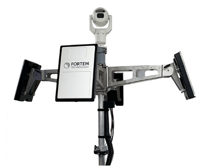
In recent “bad-drone” incidents, people have tried to smuggle contraband into prisons, flown into landing flight paths at airports, and even successfully inflicted significant damage on oil storage facilities in Saudi Arabia — never mind a failed assassination attempt in Venezuela. And with illegal immigration and drug smuggling becoming crisis issues, DHS has decided that its probably time to build a level of protection at U.S. borders. A trial is now scheduled at the quieter and more orderly Canadian border so that DHS can fully focus on evaluating the Fortem SkyDome system.
TrueView radar detects and calculates the location and trajectory of hundreds of airborne objects quickly and accurately. (Photo: Fortem Technologies)
Bad actors attacking a facility using a drone, sometimes with explosives strapped to it, have set their target as a waypoint and switched off the radio control link. The drone then carries on to its target, without fear of radio “sniffer” detection systems picking it up and jamming the control link.
Fortem built a drone defense system that uses radar for “RF silent drone” detection. Not only does the Fortem SkyDome system detect unwanted intruder drones, but it also can send out a DroneHunter UAV which hones in on and fires a net to capture, immobilize and bring back the offending drone so the defenders can investigate the attack.
Boeing UAV refuels F-18 fighter aircraft
Boeing is engaged in development of an unmanned tanker vehicle for the U.S. Navy. The company has built and flown the first test drone, known as Stingray MQ-25 T1. Boeing has another seven unmanned refueling tankers on order. T1 is the first test article for the program. Following a number of successful initial handling, control and envelope extension test flights — including several with the Navy refueling pod installed under the T1 left wing — fuel was loaded, and on June 4, a Navy F/A-18 Super Hornet fighter aircraft accompanied the T1 into the air on another test flight.
T1 Stingray refuels a Navy F/A-18. (Photo: U.S. Navy/Boeing)
The F/A-18 flew close to and maneuvered around the drone for some time, and when the pilot and test managers concluded that both were in joint, controlled, stable flight, the MQ-25 was commanded to extend the refueling pod hose and drogue. The F/A-18 normally refuels in the air from another F/A-18 configured with the same refueling pod and refueling boom, so the actual transfer of fuel which then took place was somewhat commonplace for the F-18 pilot, save that the slipstream buffet was probably less significant. Nevertheless, this was the very first time that a Navy aircraft has been refueled by an unmanned aircraft.
After further MQ-25 T1 test flights, the tanker-drone will be transported to Norfolk, Virginia, for deck handling trials aboard a U.S. Navy carrier later in the year. The MQ-25 Stingray is planned to take over this airborne refueling work which is currently handled by other F/A-18s, freeing up the fighter aircraft for operational fighter missions.
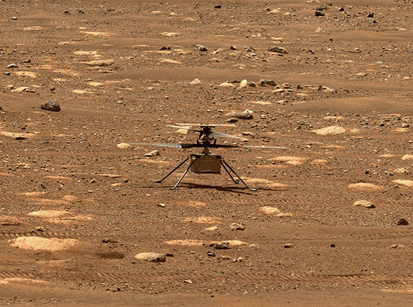
Mars drone flight experiences navigation anomaly
On May 25, the Mars drone Integrity had been commanded to take its sixth longer, higher flight. Like a good little tech package on the end of a 220-million-mile distant signal, Integrity did as it was told. However, after around 490 feet in the Mars atmosphere, Integrity started to change speed and dramatically oscillate back and forth. Even so, the UAV managed to complete the transit to within about 16 feet of the new intended parking spot.
NASA analyzed the data sent back from the drone through the Perseverance rover. NASA discovered that the flow of images from the navigation camera had been disrupted by a missing image, and the time-stamps for the images had become incorrect.
Integrity sits safely on Mars following an in-flight anomaly. (Photo: NASA)
Integrity’s navigation system is fed by an inertial measurement unit with images from the nav camera, so the time-stamp discrepancies between what the camera was saying and what the IMU was saying gave it an unforeseen issue to resolve. The resultant bucking in flight was an effort to resolve the data time differences. Images are not used in the landing phase, so the oscillations ceased as the rover descended, and the landing was as graceful as usual.
Fortunately, it appears that Integrity has not been damaged, and NASA is working to send the little drone on further scouting missions for its companion rover. NASA’s website indicates that the drone should have flown again on June 6, but right now there doesn’t seem to be any further evidence that a flight did or did not take place.
Summary
The testing that the Pentagon has done on a couple of models of DJI drones appears to have cleared them of possible malfeasance, but otherwise the report is classified. I wonder what secret science DOD used to detect/eliminate possible illicit communications with China by the drones? And it’s high time everyone realized that these “drone -thingies” can also be used to hurt us — as new technology in the hands of people who do not wish us well almost always can.
This month I discovered that Navy F/A-18s could fly further by hanging refueling pods on other F/A-18s, thereby taking the tanking aircraft out of the regular training and combat rotation. I’m glad we’ve got a drone alternative coming that must cost a lot less and also will free up fighting assets.
Finally, it doesn’t seem that we have to worry the Mars helicopter is too broken to keep seeking the best route for the rover. There were enough margins in the navigation algorithms that the little guy didn’t wreck when the image processing hiccupped. Let’s get flying again, NASA!
A bill moving through the U.S. Congress would impose a five-year ban on United States government purchases of drones manufactured or assembled in China, reports The Associated Press. The measure reflects bipartisan concerns that the unmanned aerial vehicles (UAVs) made in China could facilitate Chinese spying on critical infrastructure.
Major commercial and consumer UAV-maker company DJI is based in Shenzhen, China. Many of its small, low-altitude drones are employed by local and regional government users in law enforcement, emergency response and surveying. The ban could affect police departments that rely on federal funds for equipment. In 2020, the Department of Homeland Security halted such grants for Chinese-made drones.
Chinese-made components, including GNSS receivers and inertial sensors, are not addressed in the bill, and the Pentagon has acknowledged that many components for non-Chinese-company drones are made in China.
While the ban wouldn’t go into effect until 2023, many federal agencies have already imposed temporary restrictions on the use of Chinese drones. The Interior Department had flown more than 11,000 drone missions before January, when the agency temporarily grounded its fleet of more than 500 DJI drones over cybersecurity concerns, according to The Hill. The Hill cites a May 6 Pentagon report. The report found no malicious code in the software for DJI’s Government Edition drones.
An analysis by Booz Allen Hamilton released in June 2020 found no evidence that DJI drones have shared sensitive information with the company or the Chinese Communist Party.
In August 2020, the Defense Department issued approval to drones from five companies:
Skydio’s X2-D. Skydio is based in Redwood City, California.
Parrot’s Anafi USA. While Parrot is based in Paris, France, the ANAFI USA drone is manufactured in the United States for U.S. customers.
Teledyne FLIR’s Flir M440 Ion. The drone was originally made by Altavian in Florida, which was acquired by FLIR in December 2020, which was subsequently acquired by Teledyne Technologies in January. Teledyne FLIR is headquartered in Wilsonville, Oregon.
Teal Drones’ Golden Eagle. Teal Drones is based in Salt Lake City, Utah.
Vantage Robotics’ Vesper. Vantage is based in San Leandro, California.
In September 2019, the Xinjiang Institute of Ecology and Geography conducted a nine-day project on the Heishan Mining Zone in Toksun County, Xinjiang Province, China.
The CHCNAVBB4 UAV was combined with the AlphaUni 900 lidar solution to capture data and produce a topographic map of the mining area at a scale of 1:500. The point-cloud data was collected for subsequent 3D modeling to facilitate asset management and inventory work.
In another project, CHCNAV provided training and equipment for a China Railway No. 10 Engineering Bureau project. For this project, CHCNAV’s BB4 UAV was combined with the AlphaUni 1300 lidar system and deployed to study the topography of the tunnel mouth in Liangshan, Sichuan province.
The BB4 is a high-end unmanned aerial system resulting from an alliance between the two companies in their respective segments. Its scientific design and highly integrated production technology come from CHCNAV — a global manufacturer specialized in efficient geospatial measurement technologies — and its fully automated flight control system from DJI, pioneer in the manufacture of commercial UAVs.
The AlphaUni 900 and AlphaUni 1300 are high-end multi-platform lidar systems, designed and improved by CHCNAV through many years of exploration and data-capture experience. Both are fully integrated systems with high-precision, long-range laser scanners that provide unique waveform lidar technology from Riegl and a high-accuracy inertial navigation system.
The AlphaUni systems can take on demanding surveying missions in the air and on the ground that require the highest quality of data.
The Empire State Building sits atop a massive and solid foundation that hardly anyone ever sees. Above ground it has 2.8 million square feet of offices and hundreds of businesses. It houses 15,000 workers. Yet it would all come crashing down if the underlying and unseen foundation weren’t incredibly strong and dependable.
Timing is the unseen foundation of every networked technology, digital broadcast, financial transaction, electrical grid management and of most navigation systems, just to name a few applications. Yet, as GPS World readers know, signals from our dominant source of timing — GPS — are very faint and easily disrupted.
Short term, localized disruptions happen all the time, and many systems have adapted. A delivery driver using a jammer to hide from his boss is unlikely to disrupt a cell base station as he passes by, for example.
Photo: Georgijevic/E+/Getty Images
But more serious threats are out there. More and more hobbyists are finding ways to spoof receivers. Every few decades the sun flares strongly enough to fry satellites or charge the ionosphere. And because there are so few alternatives, GPS and other GNSS have become huge, tempting targets for adversary nations, terrorists, and sophisticated hackers.
Instead of Manhattan bedrock, our timing foundation is sometimes more like shifting sands.
Systems engineering tells us that, if something is essential, there ought to be two, three or more independent ways of receiving it. Most aircraft, for example, have two or three systems powering the flight controls — because controlled flight is important!
The white paper “A Resilient National Timing Architecture” outlines how the United States can leverage existing infrastructure and provide all citizens two, and many of them three, independent paths to coordinated universal time (UTC).
It proposes a national timing back- bone of mature technologies with very different failure modes — GNSS, eLoran and fiber. This combination will provide rock-solid timing at the 500 ns or better level of accuracy relative to UTC everywhere across the nation, and at 100 ns or better in major metro areas. Users accessing two or more systems would be nearly bulletproof to timing service disruptions.
The National Timing Resilience and Security Act of 2018 mandated a terrestrial system to back up GPS timing. Our white paper provides a path forward.
Complying with the law while benefiting current and future technologies should be sufficient motivation. If it isn’t, we must also realize that not acting on this will continue to place us behind other nations such as the United Kingdom, South Korea, Russia and China — all of whom are actively reinforcing their national timing systems.
The task will not be a simple one. Yet America was able to overcome the expense and difficulties of building GPS, at the time the world’s most refined and complex technology, and put it in space. By comparison, establishing a resilient national timing architecture using existing technology in our homeland would be child’s play.
Timing is essential. It is infrastructure for our infrastructure. If our national timing is weak, so is everything that is built upon it.
We will profit from ensuring our timing is as strong, resilient, and easily accessed as possible.
“Seen & Heard” is a monthly feature of GPS World magazine, traveling the world to capture interesting and unusual news stories involving the GNSS/PNT industry.
Photo: welcomia/ iStock / Getty Images Plus / Getty Images
COVID brings better measurements
A new study shows that the quality of GNSS reflectometry measurements may have improved significantly during the pandemic because of the lack of cars parked near the ground station. The study, carried out by geodesists from the University of Bonn, investigated the location of a precise GNSS antenna in Boston, Massachusetts, where parked cars near the ground station decreased accuracy from 2 to 4 centimeters. GNSS reflectometry is used for earthquake early warning systems, determining flood risks, and many other geodesy applications. Read more about the study.
Photo: Daniel Leeb/Iceland Space Agency
But can you press the right button?
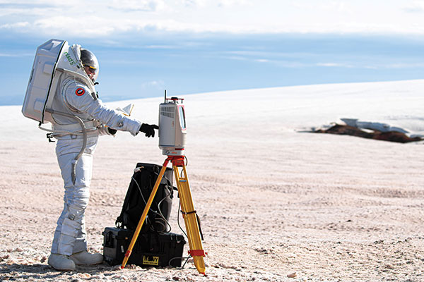
A Riegl long-range terrestrial laser scanner helped field test the newly designed MS1 Mars Analog Spacesuit. The test simulated how the new spacesuit design would perform in a polar, Mars-like environment ‚ in this case atop the Grimsvötn Volcano on the Vatnajokull Glacier in Iceland. The field test was part of a research expedition conducted by the Iceland Space Agency. The team included NASA Coordinator and Rhode Island School of Design (RISD) Professor Michael Lye, who led the team that designed the MS1, and doctoral students from the University of Iceland.
In June, a fleet of 300 Chinese fishing vessels entered the waters of the Galápagos Islands, reports environmental news website Mongabay. The ships had ostensibly turned off their GNSS-based automatic identification system (AIS) transponders to engage in illegal activities. Their presence was detected by their overhead lights and industrial jigging machines to attract and catch squid. An analysis of radio-signal data also detected unidentified ships within Ecuador’s Galápagos exclusive economic zone (EEZ).vThe new data provide additional, but still inconclusive, evidence that the Chinese fleet may have entered Ecuador’s EEZ.
A pilot program in Shenzhen will use China’s BeiDou to regulate bike-sharing and address the problem of bikes parked chaotically or in unpermitted areas, according to Chinese news service Caixin. The program is part of Beijing’s push for wider adoption and commercialization of BeiDou. With guidance from the city’s transportation bureau, BeiDou modules on shared bikes will display parking spots. Users will have to park them within geofenced parking spots.