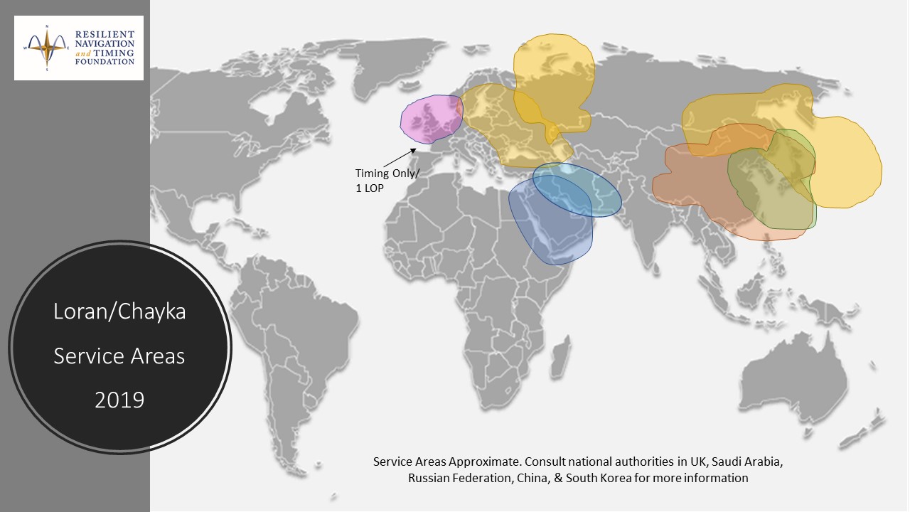
An August 2020 paper published by the journal Sensors revealed China’s plans to expand coverage of its terrestrial Loran positioning, navigation and timing (PNT) system with three new transmitter sites in the western part of the country. The article indicates that this is a part of providing a backup system for GNSS.
According to the paper, “…the vulnerability of GNSS to unintentional and intentional interference signals can be found frequently nowadays. For national security and economic effectiveness, a reliable and complementary navigation system is needed desperately. The suitability of the Loran for a backup navigation system has been evaluated and reported.”
China has operated a Loran system for decades. While the system is capable of operating independently, its signals are also compatible with systems operated by South Korea and Russia. These are coordinated through the Far East Radio Navigation Service (FERNS) to ensure the systems are complementary and reinforce each other where coverage overlaps. The United States and Japan were also members of FERNS until they terminated Loran transmissions in 2010 and 2015, respectively.
Image: RNT Foundation
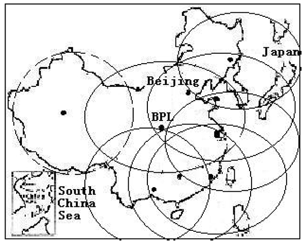
Little public information about China’s Loran system has been available and our queries have gone unanswered. One of the few documents available in the west is a 2014 paper about Loran-C from the Chinese Academy of Sciences in Shaanxi, China which can be accessed through the RNT Foundation website. It shows substantial Loran coverage in the eastern part of the nation, but only a broken circle indicating “projected coverage” in the west.
Graphic from 2014 Chinese Academy of Sciences paper on Loran showing projected coverage in the western part of the country with a dotted circle. (Image: RNT Foundation)
The single transmitter in that area projected by the 2014 paper could provide a strong, difficult to disrupt timing signal for fixed receivers with known locations.
Three new transmitters will be installed according to the August 2020 paper titled “High-Accuracy Positioning Based on Pseudo-Ranges: Integrated Difference and Performance Analysis of the Loran System.” The increased service in the western part of the country will provide “full coverage” positioning, navigation and timing usable by both fixed and mobile receivers.
The August 2020 paper is the first known documentation in over a decade of specific Chinese intentions regarding its Loran system.
Still, it is not a surprise to many observers. At 2019’s Stanford PNT Symposium, Xiaochun Lu of China’s National Time Service Center described the nation’s plan for a “comprehensive” PNT system. This system will include a wide variety of PNT sources including low earth orbit satellites, inertial systems, local positioning systems, and Loran.
Like Ms Lu, the authors of the August 2020 paper are employed at China’s National Time Service Center, which is part of the Chinese Academy of Sciences.
On Sept. 23, the China BeiDou Application Conference and the Ninth Annual Conference of China Satellite Navigation and Location Services were held in Wuhan, according to a press release from haiwainet (People’s Daily), an official Communist Party newspaper of China.
Attending the conference were 700 experts, officials and entrepreneurs, as well as company representatives from BDStar Navigation, Amap, Allystar, Unistrong and Wuhan Exsun. “Delegates agreed that China’s BDS PNT (positioning, navigation and timing) industry has just started and is ushering in a golden decade of rapid growth,” the press release stated.
Zhou Xianwang, mayor of Wuhan, said that Wuhan, an important city for BDS construction and industrial development in China, is accelerating Beidou industry innovation, application promotion and enterprise development with first-class talents and services, and striving to make Wuhan a new highland for Beidou industry innovation and development.
Yu Xiancheng, president of the GNSS and LBS Association of China, said the Beidou industry in China has reached about $58.8 billion and the industrial ecology has taken shape.
According to the press release, “China’s Beidou is the first-class Beidou and the world’s Beidou as well. The application and space-time services of Beidou technology will become more popular in China and the world, ushering in a golden decade of development.”
BDS basic products have been exported to more than 120 countries and regions, and Beidou-based land ownership confirmation, precision agriculture, digital construction and smart ports, etc. have been successfully applied in ASEAN, South Asia, Eastern Europe, West Asia and Africa.
China will lose access to a strategic space tracking station in Western Australia when its contract expires, a decision that could affect BeiDou constellation service in the Pacific region, according to a Reuters report.
A contract between the Swedish Space Corp. (SSC) and China has given Beijing access to a station antenna since 2011, but the SSC satellite station is primarily used by the United States and its agencies.
The Swedish state-owned company told Reuters it wouldn’t enter into any new contracts at the Australian site to support Chinese customers after its current contract expires, but did not disclose the exact date.
Ground stations are a vital part of space programs given they create a telecommunications link with spacecraft. While stations have different capabilities, they can be equipped to coordinate satellites for civil-military GNSS such as Beidou, Russia’s GLONASS, the European Union’s Galileo system, and U.S.-owned GPS.
China’s space program has been increasing its access to overseas ground stations in recent years in line with the expansion of its space exploration and navigational programs.
“Generally speaking, anywhere you put a GNSS monitoring ground station will improve the accuracy of positioning for that region,” said Joon Wayn Cheong, a senior research associate at the University of New South Wales’ School of Electrical Engineering.
China wants to remove its dependence on GPS as part of broader plans to expand its global influence, says Christopher Newman, professor of Space Law and Policy at Northumbria University in Newcastle, England. “GPS could be made unavailable to them in a military conflict. An independent secure system is crucial for the capabilities of the People’s Liberation Army [China’s military] with respect to targeting, weapons, navigation,” he told Reuters.
Beijing last year reestablished diplomatic ties with the small Pacific island nation of Kiribati, where it has a mothballed ground station.
GPS technology is doing far more than helping us navigate or receive accurate time. It is now being used to fight the spread of the global COVID-19 pandemic.
Global navigation satellite systems are being used to collect big data on travel and contact, but they are also being used in more unconventional ways: for example, quarantine enforcement and sanitation technology.
Read on to learn about a few recent developments in the world of GNSS/GPS that are bolstering the battle against the novel coronavirus.
Electronic monitoring enforces quarantine
There is a surge of applying ankle monitors to track sick individuals and deter them from spreading the virus further. According to BloombergBusinessweek, one business is thriving because of it: providers of electronic ankle monitors.
Kentucky courts are requiring GPS ankle monitors for people who test positive for COVID-19 and refuse to self-quarantine. Kentucky couple Elizabeth and Isaiah Linscott were two of a growing number of people placed under house arrest after Elizabeth tested positive for COVID-19 and denied signing the Self-isolation and Controlled Movement Agreed Order, a health department document promising she would stay home.
Photo: Regulus Cyber
Elizabeth told Louisville television station WAVE 3 News that she did not sign because she disagreed with the wording of the document. She said that she was concerned about having to contact the health department before traveling, even in the case of an emergency.
“My part was if I have to go to the ER, if I have to go to the hospital, I’m not going to wait to get the approval to go,” she said.
A few days after Elizabeth refused to sign the paperwork, her husband opened their door to an entourage of law enforcement officers serving them with a Health Department order to wear ankle monitors.
“I open up the door, and there’s like eight different people, five different cars, and I’m like ‘what the heck’s going on?’ This guy’s in a suit with a mask. It’s the Health Department guy, and they have three papers for us. For me, her and my daughter,” Isaiah said.
The Linville family is now confined to a 200-foot radius. If they leave their designated quarantine area, their ankle monitors will alert law enforcement.
Alternative to prison
The number of people on house arrest in the United States and across the world has surged as corrections departments struggle to slow the spread of the coronavirus within prisons. An estimated 25 to 30 percent more people are wearing ankle monitors in comparison with a few months ago, according to Bloomberg Businessweek. The U.S. Federal Bureau of Prisons reported a 160 percent increase in home confinement from late March to July. European corrections departments have similarly put thousands of inmates on house arrest in the last few months.
“Demand has spiked everywhere,” BI Inc. monitoring equipment executive Robert Murnock said to Bloomberg. “We’re getting calls from different jurisdictions and other countries we’ve never worked with.”
Efforts to reduce crowding in prisons mean that the electronic monitoring industry is one of very few industries benefiting financially from the coronavirus pandemic.
“Coronavirus gives electronic monitoring companies an opportunity like they’ve never had before to expand,” parole reform expert James Kilgore said.
On Aug. 3, Singapore announced the rollout of electronic tracking devices to enforce quarantine. Travelers will be required to wear GPS and Bluetooth-powered tracking devices that notify authorities if quarantine is broken or the device is tampered with. The rule went into effect on Aug. 11 and applies to all incoming travelers — resident or nonresident — over the age of 12.
On Aug. 20, the premier of Western Australia, Mark McGowan , said his government could soon force people in hotel quarantine to wear electronic monitoring equipment if they are deemed a risk. “If we identify people who are potential flight risks or who might have a criminal history, we are looking at applying monitoring bracelets to them,” he said.
An estimated 25 percent to 30 percent more prisoners are wearing bracelets now compared to the pre-outbreak period. In the U.S., the Federal Bureau of Prisons has placed about 4,600 inmates in home confinement, a 160 percent increase since the end of March.
“Demand has spiked everywhere,” said Robert Murnock, vice president for partnership development at BI Inc., a provider of EM technology.
The emergency shift to electronic monitoring spurred by COVID-19 may foretell a long-term shift toward use as an alternative to prison time, reducing clutter and the risk of the virus spreading among inmates.
Photo: LeoPatrizi/E+/Getty Images
Contact tracing via mobile phones
Israel is using covert mobile phone data to track the spread of COVID-19. On July 1, the Knesset approved a bill temporarily reauthorizing mass surveillance of coronavirus-infected citizens by the Shin Bet, Israel’s internal security service. The original program lasted from mid-March to June 9.
The contact-tracing program works like this. When a patient is diagnosed with COVID-19, the Israeli Health Ministry provides their personal information — including their mobile number — to the Shin Bet. The Shin Bet then consults a classified database of every person who uses Israeli telecom services to determine who came into contact with the infected individual for more than 15 minutes at a time. After the Shin Bet sends information back to the Health Ministry, the Health Ministry notifies those people via text and tells them to self-quarantine.
The Shin Bet’s newfound role in public health enforcement is quite different from its usual focus. Former Shin Bet agents say the COVID-19 mobile phone tracking technology was originally developed as a counterterrorism measure, and the tracking system being used on Israeli civilians is almost identical to that used for suspected terrorists.
“It’s the same system, the same methods,” retired Shin Bet agent Arik Brabbing said to BBC. “We know that someone was here in the park. We can get from the [mobile phone] company all the details about the hour, the place, exactly the place… and we can understand who else was around.”
Supporters of the mass surveillance program, including Prime Minister Benjamin Netanyahu, argue that reduced privacy is necessary to curb the spread of the virus. However, the Israeli government has come under fire by opponents who claim that the program is intrusive and undemocratic.
Israel’s contact tracing procedures are more secretive than those of South Korea and Taiwan, other countries that mandate central mass surveillance. South Korea and Taiwan both enforce quarantines with mobile-phone tracking, and both have built publicly available COVID-19 data platforms.
The South Korean government has disseminated detailed — but anonymized — information about COVID-19 carriers, including their travel routes and treatment facilities. Citizens broadly support these measures — a testament to collectivism in Korean culture.
Civic engagement and enthusiasm for fighting the pandemic is also remarkable in Taiwan, where the public has been collaborating with the government on a town hall-style website called vTaiwan. Citizen-led initiatives, like a GPS-powered tool for tracking face mask supplies, have been applied nationwide.
Meanwhile in Europe, eight major telecom companies, including Vodafone and Orange, have been supplying anonymized metadata to the European Commission to model and predict the spread of the virus. In the United States, the Centers for Disease Control and Prevention is soliciting GPS data from mobile advertising companies rather than carriers themselves.
The two tech giants, Apple and Google, made it easier for health agencies to join its coronavirus exposure notification system, creating a new built-in app within iOS and Android. The app provides real-time notification to users when they are exposed to a sick person.
Virus-killing robots may roam the streets
GPS-based robots, drones and autonomous cars are being deployed to sanitize outdoor spaces, transport medical equipment, and announce safety information to the public.
Robots began rolling around the streets of Wuhan, the original epicenter of the coronavirus outbreak, as early as January. China was the first to deploy robots of this type, but India, Spain, France and other countries have followed in their footsteps. In addition to the chemical-spray approach, some companies are pioneering mobile disinfection robots armed with large ultraviolet-C germicidal lights.
Apollo, the autonomous vehicle company of multinational internet giant Baidu, has partnered with Chinese self-driving startup Neolix to transport food and supplies to Beijing Haidian Hospital. Every morning at 10:30 a.m, an unmanned car delivers meals to about 100 frontline workers. The process eliminates direct contact, protecting the safety of food service workers, hospital staff, and patients.
Zhangjiang Artificial Intelligence Island
A fleet of Apollo and Neolix’s unmanned cars is also responsible for disinfecting all roads on Zhangjiang Artificial Intelligence Island, an 100,000-square-meter industrial complex in Shanghai. The vehicles are loaded with up to 160 liters of spray disinfectant and can cover the island’s entire road system in about half an hour.
The vehicles at Zhangjiang AI double as nighttime surveillance bots. They patrol the island and make sure that guests are adhering to coronavirus protocols, alerting security personnel if they note suspicious activity.
In addition to using drones to spray disinfectant, South Korea’s government has leveraged the technology for public announcements. On July 4, 300 drones lit the sky above Seoul in a show of appreciation for frontline workers. The drones executed a 10-minute synchronized show that included images of face masks, hand washing, and social distancing.
Summary
As COVID-19 continues to ravage the globe, governments rely on GPS to track the virus, contain it, and fight against it. The battle against coronavirus is still being waged on a global scale, utilizing GPS as a weapon along with many other existing technologies.
The pandemic changed the world forever, and it also highlighted the power of tracking and monitoring location of people and machines. It is another testament to the immense reliance on GPS technology in our modern world.
The increased deployment of these technologies necessitates increased security measures, especially when public health is on the line. Regulus Cyber offers GPS Cybersecurity software. To read more about it, visit www.regulus.com.
Current u-blox GNSS platforms — from u-blox M8 and beyond — support the recently completed BeiDou navigation satellite system modernizations, improving the availability of GNSS positioning services.
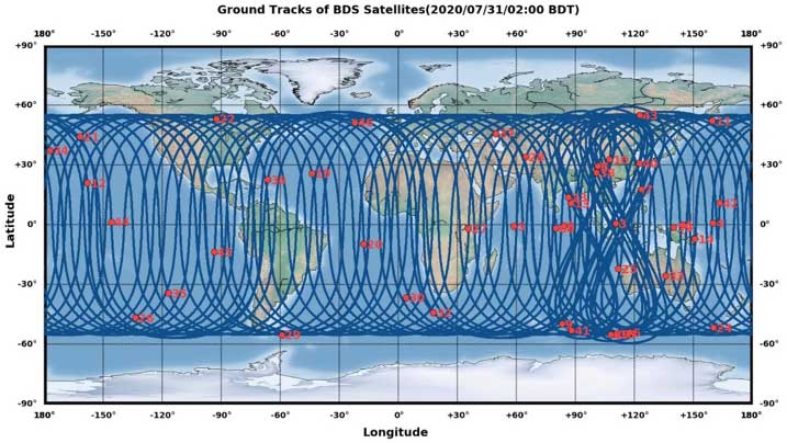
The opening ceremony of the BeiDou-3 global navigation satellite system (GNSS) was held in Beijing on July 31, officially celebrating the expansion of coverage offered by the critical Chinese space infrastructure to a global user base.
As a global supplier of GNSS positioning and wireless communication technologies, u-blox has been driving technological innovation and deeply involved in the Chinese market for many years.
Tests conducted across China and Europe have shown that including the BeiDou system can improve the positioning accuracy of GNSS receivers when multiple navigation satellite systems are tracked concurrently. When signals are partially obstructed, positioning accuracy can be significantly improved by incorporating the BeiDou system.
Data shows that in 2019, the overall output value of the Chinese satellite navigation and location service industry reached nearly 345 billion yuan, an increase of 14.4% over 2018, with the output value expected to exceed 400 billion yuan in 2020.
Graphic: China Satellite Navigation System Management Office Test Evaluation Research Center
Additional Services Provided by BeiDou
The BeiDou system provides a suite of additional services, including satellite and ground-based augmentation services, precise single-point positioning, precise timing and global short message services, laying a solid foundation for BeiDou’s ubiquitous navigation and tracking applications.
Applications of GNSS technology continue to diversify, leveraging the all-weather, all-time, tracking, navigation and timing services it offers. GNSS technology is penetrating deeper into traditional industrial verticals, such as agriculture, forestry, animal husbandry and fishery, power and energy, as well as in railway and air transportation, including their infrastructure construction and management.
At the same time, GNSS technology has become an indispensable and “smart” factor in emerging application fields such as the internet of things and the “internet of vehicles,” as well as in innovative applications such as autonomous driving, automatic parking and automatic logistics, and is now commonplace in many industrial and consumer use cases.
“U-blox has been closely following the modernization of the BeiDou navigation system and is ready to work with partners in various industries to promote the expansion of industry applications, expand emerging markets and jointly create a green industry ecosystem,” said Hamilton Chen, China country manager at u-blox.
Recent completion of China’s BeiDou satellite navigation system has rekindled privacy and security concerns among some in the West. China has incorporated a two-way messaging capability into BeiDou that many fear will be used to track individuals and install malware on user devices.
Most satellite navigation experts view such concerns as far overblown.
At the same time, though little discussed, BeiDou’s completion does signal a new phase for China’s status as a world power and its ability to challenge the West on many fronts.
Two-way communications
It is possible for specially equipped receivers to communicate back to the BeiDou constellation. But this is not true for the vast majority of receivers (including those in cell phones). Industry experts say that all mass market chips for every GNSS system, including BeiDou, are “receive only.” Only specially equipped devices will be able to take advantage of its two-way communications capability, and it should be quite apparent to users when it is in operation.
Users, they say, should be much more concerned about location privacy and security issues that have been around for decades. Mobile phones have long reported user locations through the cellular network based upon information derived from GPS, WiFi ranging and other position calculations. The ability to hack and compromise a cell phone or other receiver will not be affected by the addition of BeiDou as a receive-only location source.
It is also important to note that using specialized equipment for two-way communication with a Global Satellite Navigation System (GNSS) is not something new to BeiDou. While the Chinese system may have improved upon the capability, users with the right equipment can send messages using the Search and Rescue functions to the United States’ GPS, Europe’s Galileo, and Russia’s GLONASS.
China has risen
Completion of BeiDou, unquestionably a significant technical achievement, does signal a significant step up for Chin’s status as a world power and influencer. It is a declaration of technical independence from the West with wide ranging geo-political impacts.
“(1) address national security requirements by ending military reliance on GPS;
(2) build a commercial downstream satellite navigation industry to take advantage of the quickly expanding market; and
(3) achieve domestic and international prestige by fielding one of only four such global navigation satellite systems (GNSS) yet developed”
Military Power and National Security. The Chinese military has long sought its own GNSS. This was amplified during a crisis in 1996 when it fired three missiles toward Taiwan as a warning. One struck the sea about 11 miles from a Taiwanese military base, but the other two disappeared. China claims that the United States interfered with GPS signals and was to blame. The Chinese military was both horrified and humiliated.
Having a sovereign GNSS eliminates the problem of relying on the U.S., Russia, or Europe for satellite navigation. That it is the world’s newest system also certainly has its advantages. China has undoubtedly incorporated state of the art anti-jamming and anti-spoofing capabilities into the version of BeiDou used by the military. After decades of observing others interfering with GNSS signals, and doing a fair bit of it on their own, it would be hard to imagine Chinese engineers not including the latest resilience features.
An operational BeiDou also means that China’s military is much freer to interfere with GPS and other GNSS in pursuit of tactical and strategic advantage without endangering its own services and infrastructure. It is likely that the levels of jamming and spoofing seen near the Spratley Islands and mainland ports will increase. Even if they do not, the increased possibility of Chinese interference will add yet another degree of complexity and uncertainty for western military forces.
Economic Power. The technological and commercial benefits of BeiDou for China are unquestionably substantial as well. Direct benefit from the manufacture and sale of equipment, plus spinoff industries and technologies, add to an already impressive national technology and economic portfolio. This is especially true since positioning, navigation, and timing (PNT) services are a “silent utility” underpinning so many network and other technological systems. The huge domestic market and robust overseas sales continue to grow (by 20% per annum according to Chinese reports) providing huge returns.
Prestige and Soft Power. “BeiDou launch marks China’s rise to ‘major space power’” read a recent headline in the Asia Times. This is perhaps understated as, with BeiDou complete, there is, technologically, little the West has achieved that China has not equaled. This has greatly enhanced China’s global standing and made it, in the eyes of many in the developing world, an ally and provider as good or better than the U.S. or Europe.
And China is eager to share its new PNT utility with others to further, not just its economy, but more importantly its long-term strategic interests.
Forsaking GPS
Regionally, China has been encouraging neighbors to adopt BeiDou for national PNT and forsake GPS. As one example it provided Thailand with nearly $300M in foreign aid targeted to promoting BeiDou use by Thai government organizations.
Writing in July in The Diplomat, Dr. Namrata Goswami observed
“… BeiDou is located within China’s ‘Information Silk Road,’ a subset of its land and maritime silk routes under the Belt and Road Initiative (BRI). China is now able to extend influence in a multidomain environment (land, sea and space) via its BeiDou space system, which provides navigation to aircraft, submarines, missiles, as well as commercial services dependent on such navigation. China’s Ministry of Industry and Information Technology sells the Information Silk Road, to include BeiDou and 5G networks, to global audiences as a completely self-sufficient technology infrastructure that anticipates life in the 21st century.”
This extends China’s influence through BeiDou even farther and has led a number of nations to seek closer ties with China through BeiDou.
Mohamed Ben Amor, secretary general of the Tunisia-based Arab Information and Communication Technology Organization, an organization of the Arab League, told GPSDaily.com, “Cooperation on the BDS is of special significance for the Belt and Road construction…The next step of the China-Arab cooperation is to achieve further connectivity and both sides can apply the BDS to promote regional technological and economic development.”
Iran’s view
Iran has had a Memorandum of Understanding with China about BeiDou since 2015. It provides for BeiDou ground stations in Iran, access for Iran to high-precision services, and establishment of an Iranian center for space data collection.
And In a tweet last week Iran’s Ambassador to China cited BeiDou’s completion as the “…end to the monopoly of the U.S.’s GPS.” He said, “There is great potential for aerospace cooperation with China,” and went on to suggest that Iranian aerospace students could work as a bridge between the two countries.
Similar comments have been published from entities in India, Indonesia, Malaysia, and throughout Southeast Asia.
China is indeed to be congratulated for a significant achievement with the completion of BeiDou. Even more noteworthy, though, is how it has integrated BeiDou seamlessly into its national plans for technology, economic, military and diplomatic efforts — a comprehensive, coordinated program to boost its standing in the world, especially relative to the United States and Europe.
Dana Goward is president of the Resilient Navigation and Timing Foundation. He is the proprietor at Maritime Governance LLC. In August 2013, he retired from the federal Senior Executive Service, having served as the maritime navigation authority for the United States. As director of Marine Transportation Systems for the U.S. Coast Guard, he led 12 different navigation-related business lines budgeted at more than $1.3 billion per year. He has represented the U.S. at IMO, IALA, the UN anti-piracy working group and other international forums. A licensed helicopter and fixed-wing pilot, he has also served as a navigator at sea and is a retired Coast Guard Captain.
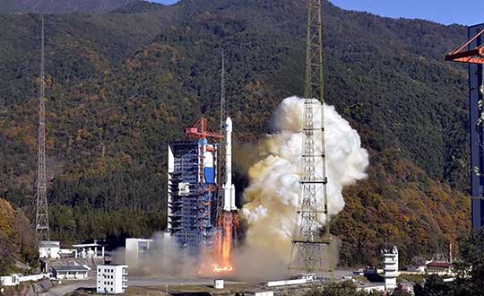
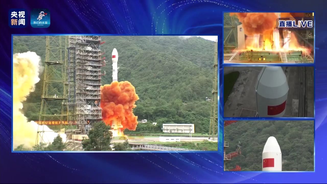
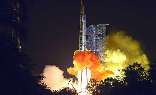
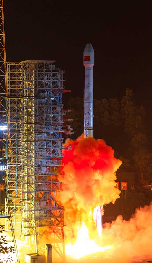
China completed its worldwide BeiDou navigation satellite system with the launch of its final satellite on June 23, according to China Global Television Network.
The satellite launched aboard a Long March-3B carrier rocket from the Xichang Satellite Launch Center at 9:43 a.m. Beijing time (0143 GMT) on Tuesday, marking the completion of the country’s domestically developed BeiDou constellation.
The launch followed a delay of after originally being scheduled for July 16 because of a technical issue discovered in pre-flight tests.
The final satellite is a geostationary earth orbit satellite of the BDS-3 system. It is the 30th BDS-3 satellite and the 55th BeiDou satellite. BDS-3 is a a 30-satellite navigation system.
BDS-3 offers high-precision positioning and short message communication.
Begun in 1994, BDS-1 was completed in 2000 to provide services to China. In 02012, BDS-2 was finished, and has provided navigation service to the Asia-Pacific region. Once the final satellite achieves orbit and is checked out successfully, BDS-3 will provide navigation services worldwide.
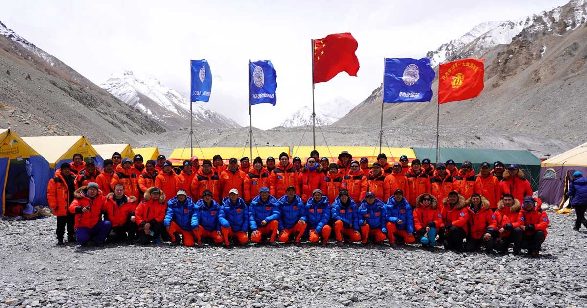
The survey team and sherpas reach the top of the world. (Photo: CHC Navigation)
China’s field work for new measurements of Mount Everest — the world’s, highest peak — are now complete. However, it will take two to three months for scientists to calculate and release its exact height, according to CHC Navigation, whose GNSS receiver was used.
The eight-member Chinese survey team reached the summit on May 27. The team erected a survey marker and installed a GNSS antenna on the snow-covered peak. The team also conducted a GNSS survey, snow depth measurement and gravity survey, said China’s Ministry of Natural Resources.
Scientists will use multiple traditional and modern measurement techniques to perform comprehensive calculations of the measurement data. After data analysis and processing, they will carry out theoretical studies and repeated verifications to determine the accurate height. Complex calculations are needed to eliminate errors caused by factors such as temperature, air pressure and the refractive environment.
CHC Navigation’s P5 geodetic GNSS receiver was successfully used by a Chinese team of surveyors to complete the 2020 Mount Everest Elevation Survey.
This is the first time that a team of Chinese surveyors has climbed the summit of Mount Everest, and it is also the first time that BeiDou-based Chinese GNSS receivers have been used to measure the height of Mount Everest, known in China as Mount Qomolangma.
China’s National Geodetic Survey Team and its Mountaineer’s Team used CHCNAV GNSS receivers. (Photo: CHC Navigation)
The Everest Project
To promote research on the Mount Everest elevation and to ensure the scientific character and accuracy of measurements, the Ministry of Natural Resources mobilized the Shaanxi Bureau of Topography and Geographic Information Mapping from the Chinese Academy of Topography and Mapping to plan and implement the measurements of the Mount Everest elevation. China’s National Geodetic Survey Team and its Mountaineer’s Team would undertake the arduous climb.
The plan set out the technical guidelines and required that the Everest Elevation Project be designed to achieve innovative and technological breakthroughs in several areas of research.
The first is to use the BeiDou satellite navigation system to perform GNSS measurements; the second is to use Chinese surveying and mapping equipment to complete the task.
Meeting Harsh Challenges
In October 2019, CHCNAV received a request from the Ministry of Natural Resources to provide GNSS equipment for the 2020 Everest Elevation Project. A dedicated team combining different departments, from R&D to manufacturing, was set up. The team elaborated the specific technical requirements from the National Survey engineers, in particular the difficulties and challenges related to the altitude of Everest.
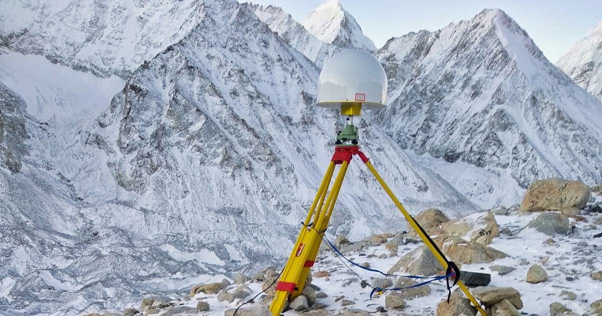
Measuring the height of Mount Everest, especially the summit, is a challenge, not only for the limitation of the human body in such elevation environment, but also for the performance of the GNSS receiver itself.
At over 8,800 meters, the minimum temperature can reach -45°C and the atmospheric pressure is only 30 kPa (compared to the normal 101 kPa). All the surveying equipment used is exposed to both low temperature and low-pressure constraints.
In addition, the operation of the instruments must be as simple and reliable as possible in such an extreme environment. Surveyors wear thick winter clothing and lack oxygen, making every movement an extreme challenge. Finally, the measurement of the mountain peak must be completed at the first attempt, as re-measurement is impossible.
To meet these stringent requirements, CHCNAV has provided GNSS receivers that have passed the most rigorous environmental and reliability tests. The entire solution, from the GNSS receivers to the accessories, has been optimized to ensure mission success from the very beginning.
A wide temperature range of material — supporting an operating temperature range of –45°C to +85°C — were used, including redesigned lithium-ion batteries offering 12 hours of operation even at extremely low temperatures. Also used were antenna cables with a specific compound material to avoid any cracking or signal attenuation.
To ensure reliable operation of the receivers in a low-pressure environment, the GNSS receivers have built-in waterproof and breathable valves to maintain internal and external pressures. The low-pressure tests replicated a 25-kPa environment, corresponding to an altitude of 10,000 meters.
Additional ruggedized reinforcement prevented damage in the event of accidental receiver drop thanks to a robust design to keep the display and connectors safe. Following CHCNAV tests, third-party organizations were commissioned to perform environmental testing and reliability verification, including storage and operating at high/low temperatures, vibration, shock, rain, dust, humid heat, salt and fog.
From November 2019 to March 2020, CHCNAV’s GNSS equipment was supplied to the National Photoelectric Rangefinder Testing Center — under the requirements of the China Academy of Surveying and Mapping — for the most rigorous evaluation. As a result, the company’s GNSS receivers were selected to provide the peak altitude measurements of Everest in 2020.
The climb to the summit. (Photo: CHC Navigation)
Reaching the Summit
On April 5, 2020, at the Everest Elevation Survey Expedition Ceremony in Lhasa, CHCNAV officially donated GNSS equipment to the National Survey Team. Both product and technical training was provided to the team.
The 53 members of the first National Survey Team overcame the difficulties related to the environment, bad weather and the additional impact of COVID-19, and conducted a series of measurements on Mount Everest and surrounding areas such as level, gravity and GNSS.
Thirty of the 60 points of the GNSS control network were measured with CHCNAV GNSS receivers, including three of the seven Everest elevation intersection points.
On May 27, the CHCNAV GNSS receivers finally reached the summit and successfully completed the task.
The successful achievement of the Everest elevation measurement reflects the performance of the Chinese surveying and mapping industry, confirms BeiDou as a major part of the GNSS systems, and demonstrates the technical success of CHCNAV as a major player in the GNSS industry.
About CHC Navigation
Founded in 2003, CHC Navigation is a publicly listed company creating innovative GNSS navigation and positioning solutions. With a global presence across the world, distributors in more than 100 countries, and more than 1,300 employees, CHC Navigation is today recognized as one of the fastest-growing company in geomatics technologies.
The 45th satellite of the BeiDou Navigation Satellite System — launched on May 17, 2019 — has started operation in the network after completing in-orbit tests, reports China’s Xinhua news service.
The satellite will provide services in place of the third BeiDou satellite, a geostationary earth orbit satellite of the BDS-2 system, according to China’s Satellite Navigation System Management Office.
The replacement will help reinforce the BDS-2 system and support a smooth transition from the BDS-2 system to the BDS-3 system. The third satellite — launched Jan. 17, 2010 — will stay in orbit after the replacement.
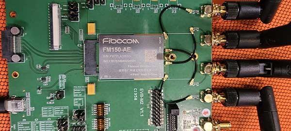
Fibocom’s 5G modules FG150 and FM150 have completed the first data call and end-to-end data transmission services under China Mobile’s Standalone-Structured 5G network. The download rate exceeds 100 Mbps.
Fibocom is a leading provider of cellular embedded wireless module solutions for the internet of things (IoT).
Fibocom FG150 and FM150 5G modules are the first 5G modules based on the Qualcomm SDX55 platform to offer the data-transmission services under the SA-structured 5G network in China, Fibocom said. Its IoT wireless modules incorporate GNSS receivers that receive GPS, GLONASS, Galileo and Beidou signals.
See a test video here:
“Wireless modules are essential for communication between IoT terminals and the base stations. As the world’s leading IoT wireless module solution provider, we are proud that our 5G modules have achieved another R&D milestone in the industry,” said Tiger Ying, CEO of Fibocom. “The completion of the first data call under SA-Structured 5G network is a significant step towards realization of all the three 5G features (eMBB, uRLLC, mMTC) in IoT industry and helps our customers to accelerate the large-scale deployment of 5G industry applications.”
The test was run on the Fibocom FM150 5G module with China Mobile’s 5G SIM card under the n41 network frequency band in the Shenzhen Mobile 5G Joint Innovation Center.
The Fibocom FM150 5G module has been successfully registered on the 5G SA network and established the PDU session. In the 5G SA communication process, the establishment of the PDU session is a symbolic link for successful dialing.
Photo: Fibocom
Fibocom FG150 and FM150 5G modules support both 5G SA and NSA network architectures, providing an integrated multi-network solution that is compatible with the global 5G Sub 6 and millimeter-wave bands. Fibocom 5G modules are compatible with both LTE and WCDMA standards, reducing customers’ investment in the early stages of 5G deployment and helping customers to switch their older product lines to 5G product lines quickly.
Fibocom’s 5G modules have global coverage, accelerating scale deployment of the 5G IoT applications. Applications include: 4K/8K video live broadcast, cloud office (ACPC), drone, robot, AR/VR, 5G virtual dress mirror, 5G cloud game, 5G digital signature, 5G wireless gateway, 5G CPE, 5G SD-WAN, smart grid, telemedicine, connected cars, intelligent transportation system, autonomous driving, smart homes and smart cities.
PCCW and Unistrong will collaborate on developing GNSS technologies and services for the telecommunications and aviation industries.
PCCW Global is the international operating division of HKT, a Hong Kong telecommunications service provider. Beijing UniStrong Science and Technology Corporation Limited is a navigation and positioning company.
The collaboration intends to link satellite positioning to 5G mobile networks to provide positioning data accurate to within centimeters. The link will unlock new services for telecommunications providers rolling out new networks to support the internet of things (IoT), smart cities and the aviation industry.
UniStrong’s experience in developing high-precision products, solutions and services will enable PCCW Global to integrate new services with 5G mobile infrastructure, providing high-precision positioning (HPP) accurate down to centimeter levels.
This integration of precision positioning expertise and technologies has the potential to revolutionize industries such as commercial drone operations, autonomous vehicles and transportation, logistics, construction, agriculture and others.
New Airport Technology
The integration of technologies will also enable the provision of smart aviation solutions for airport authorities. Based on high-precision positioning and navigation technology, new airports will be able to leverage smart civil construction works that will facilitate safer and more efficient airport operations.
These aviation technologies will also be able to integrate with a wide variety of IoT sensors, edge-computing capabilities, machine vision and other artificial intelligence (AI) technologies to create intelligent surveillance platforms capable of managing and enhancing many aspects of airport safety and efficiency.
The installed base of GNSS devices in use globally is forecast to increase from 6.4 billion in 2019 to 9.6 billion in 2029, with Asia-Pacific continuing to account for more than half of the global GNSS market.
In terms of global annual GNSS receiver shipments, the market is forecast to grow from 1.8 billion units in 2019 to 2.8 billion units in 2029, according to the 2019 GNSS Market Report by the European Global Navigation Satellite Systems Agency (GSA).
“As a global ICT service provider with extensive high speed fiber networks and cloud services coverage worldwide, we are delighted to cooperate with UniStrong with the aim to offer unique, game-changing solutions in Satellite High Precision Positioning (SHPP) and Continuous Operating Reference Station (CORS) solutions ideally suited to the new era of 5G, IoT and smart cities,” said Benney Cheng, head of Strategic Project and Development, PCCW Global.
“The cooperation between UniStrong and PCCW Global will further promote the development of professional solutions and applications that are oriented towards global users’ needs,” said Jun Shen, corporate vice president and chief scientist of UniStrong. “Based on GNSS technologies, and deeply integrated with communication technologies, Big Data, Industry 4.0, IoT, artificial intelligence and other technologies, these solutions will empower and influence more industries and countries, and promote BDS/GNSS global applications and international services worldwide.”
Photo: Bill Oxford / iStock / Getty Images Plus / Getty Images