Tag: China

  • Analysis of satellite imagery shows reduced NO2 in China, Italy

    Analysis of satellite imagery shows reduced NO2 in China, Italy

    Screenshot: ESA video
    Screenshot: ESA video

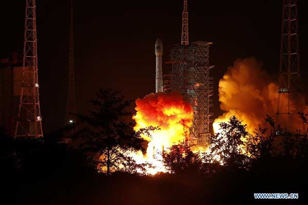
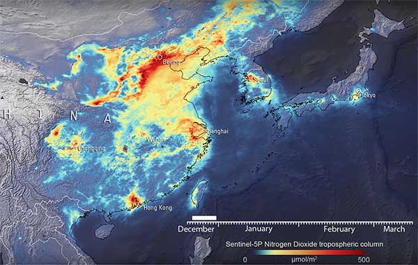
    Descartes Labs, a geospatial data analytics company, is using satellite imagery analysis to examine how the coronavirus reduced nitrogen dioxide (NO2) emissions in China.

    NO2 is produced by vehicles, power plants and heavy industries such as cement manufacturing, which were shut down during the coronavirus epidemic.

    Descartes Labs shared its visualization in a Facebook post. The visualization maps a time series of NO2 levels across Eastern China, Japan and the Korean Peninsula using data from the European Space Agency (ESA)  Sentinel-5P satellite.

    Plots of NO2 emissions from 2019 compared to 2020 show declines of nearly 60%. Read more on Descartes Lab’s blog.

    Copernicus data shared

    In a video provided by ESA, a drop in concentrations in late January is visible in China, coinciding with the nationwide quarantine; from the beginning of March, the nitrogen dioxide levels have begun to increase.

    Italy reduction

    Copernicus data also reveals the decline of air pollution, specifically nitrogen dioxide emissions, over Italy. This reduction is particularly visible in northern Italy, coinciding with its nationwide lockdown to prevent the spread of the coronavirus.

    “Satellites offer a unique vantage point to monitor the health of our planet,” said Josef Aschbacher, ESA’s director of Earth Observation Programmes. “Sentinel-5P is one of seven Copernicus satellites in orbit today. It currently provides the most accurate measurements of nitrogen dioxide and other trace gases from space.

    “As nitrogen dioxide is primarily produced by traffic and factories, it is a first-level indicator of industrial activity worldwide,” Aschbacher said. “What is clearly visible is a significant reduction of nitrogen dioxide levels over China, caused by reduced activity due to COVID-19 restrictions, but also the Chinese New Year in January. The Copernicus programme is a perfect example of how space serves all European citizens by combining the political strength of the EU with the technical excellence of ESA.”

    “We can certainly attribute a part of the nitrogen dioxide concentration reduction to the impact of the coronavirus,” said Claus Zehner, ESA’s Copernicus Sentinel-5P mission manager. “We currently see around a 40% reduction over Chinese cities, however these are just rough estimates, as weather also has an impact on emissions. We are conducting a detailed scientific analysis which will soon provide more insights and quantified results in the following weeks and months.”

    The Copernicus Sentinel-5 Precursor mission, also known as Sentinel-5P, is dedicated to monitoring air pollution by measuring a multitude of trace gases as well as aerosols — all of which affect the air we breathe.

  • China fights coronavirus with delivery drones

    China fights coronavirus with delivery drones

    Through its group company Antwork, Japanese company Terra Drone is employing its UAV system to transport medical samples and quarantine supplies in China to fight the coronavirus.

    At 9 a.m. on Feb. 6, a medical delivery drone flew from the People’s Hospital of Xinchang County to the disease control center of Xinchang County, marking the launch of the first urban-air transportation channel to help to fight the novel coronavirus (COVID-19 ), a global health emergency.

    Take off and landing point of Xinchang people's Hospital. (Photo: Terra Drone)
    Take off and landing point of Xinchang people’s Hospital. (Photo: Terra Drone)

    The World Health Organization reports at least 95,270 people are infected and at least 3,280 have died. China, where COVID-19 originated, is in a tense period of epidemic prevention and control. Xinchang County is in Zhejiang province — one of the areas most severely hit by the virus.

    As soon as the Wuhan quarantine began on Jan. 23, Antwork petitioned to provide drone technical support.

    Antwork’s RA3 and tr7s drones and unmanned RH1 station are ensuring that medical samples and quarantine materials can travel with minimal risk between Xinchang County People’s Hospital and Xinchang County’s disease control center. The automatic, unmanned air delivery system significantly reduces contact between samples and personnel, as well as improves delivery speed.

    Antwork branch company Aerodeli, which undertook the operation, obtained the first urban drone delivery license issued by the Civil Aviation Administration of China (CAAC) in October 2019. The sample delivery work is carried out in strict accordance with certified operation procedures to ensure the safety of medical samples during transportation.

    Take off and landing point of disease control center of Xinchang County. (Photo: Terra Drone)
    Take off and landing point of disease control center of Xinchang County. (Photo: Terra Drone)

    Using drones has increased the speed of transport by more than 50% compared to road transportation, proving to be a more efficient means of transportation for epidemic prevention and control. The drones also relieve the personnel shortage as more and more medical staff and ambulances are transferred to the front lines — making the best use of human and material resources.

    After the project for Xinchang People’s Hospital was put into operation, Antwork began assisting more medical institutions in China to deploy drone transport services for the anti-epidemic effort.

    A drone departs from the disease control center of Xinchang County. (Photo: Terra Drone)
    A drone departs from the disease control center of Xinchang County. (Photo: Terra Drone)
  • Four BeiDou satellites join system, last two launches set

    Four BeiDou satellites join system, last two launches set

    More launches planned for March and May

    Four new satellites of the BeiDou Navigation Satellite System (BDS) have passed tests in orbit and joined the system to provide positioning, navigation and timing services, according to China news service Xinhuanet.

    The four satellites include the 47th, 48th, 52nd and 53rd satellites of the BDS family, according to China’s Satellite Navigation System Management Office.

    All of them, operating in medium Earth orbit, were developed by the China Academy of Space Technology under the China Aerospace Science and Technology Corporation.

    The 47th and 48th BDS satellites were launched on Sept. 23, 2019, and the 52nd and 53rd BDS satellites were launched on Dec. 16, 2019.

    Two to the Last. The China Satellite Navigation System Management Office said the last two Beidou-3 satellite launches will take place in March and May, and complete the Beidou system.

    China began to construct its navigation system, named after the Chinese term for the Big Dipper constellation, in the 1990s and started serving the Asia-Pacific Region in 2012.

    Over the past two years, China has successfully sent 28 BDS-3 satellites and two BDS-2 satellites into orbit.

    China plans to launch more BDS satellites in March and May to complete the global network.

    Photo: XinhuaNet
    Photo: XinhuaNet
  • Coronavirus, organ transport top medical drone uses

    Coronavirus, organ transport top medical drone uses

    With Coronavirus all over the news, it’s actually encouraging to hear that China is making high-level efforts to contain the infection: two isolation hospitals built in just one week in Wuhan where the outbreak began, travel restrictions inside China, very few people being allowed to leave the country, enforced mask-wearing, and local communities in neighboring provinces blocking visits by outsiders.

    Two drone-related stories caught my attention, both in China and connected to the virus outbreak — one where drones were being used to enforce “wear-a-mask (see video), and another where disinfectant was being dispensed by drones.

    Photo: Xag
    Photo: Xag

    It’s not exactly clear who was behind recent drone flights that broadcast live warnings to people without protective masks on the streets — some villages in rural China were apparently overflown and people were advised to wear a mask while outdoors.

    Around Beijing, similar activities were maybe down to well-intentioned social media people and traffic police.

    XAG, which has fielded 42,000 agricultural spraying drones in China, is urging authorities to use its drones for widespread disinfectant spraying, and has set up a significant fund to support these activities. The company claims its drones can disinfect a local community in less than four hours, and may already have done so.

    Medical transport drones. Staying with the medical theme, Aquiline Drones (AD) in Cincinnati is a drone company operating under a Federal Aviation Administration (FAA) Part 135 Air Carrier Certificate, and is working on a system to transport human organs for transplants.

    VyrtX is an organ transport company in Ohio that has teamed with AD, with the object of creating a highway-in-the-sky across the state to overcome ground delivery delays. Apparently around 25% of precious transplant organs don’t make it in time to be used; they are lost to the patients on lengthy wait lists — and many people are dying as a consequence. There are supposedly enough donors, but organs deteriorate during ground transport and desperate transplant candidates are losing out badly.

    So the next step for VyrtX and AD are custom-designed drones for life-saving rapid transport between donor and transplant hospitals. VyrtX is working with the U.S. Air Force Research Laboratory in Dayton, the Ohio UAS Centers and four Ohio organ procurement organizations to develop the air corridor and begin rapid organ transport by drone across the state.

    The University of California, San Diego, Health (UC San Diego Health) is joining an increasing number of health organizations in developing a drone system for blood and documentation transport between its facilities. Collaborating with the UPS Flight Forward drone delivery program and with Matternet, medical payloads will travel between Moores Cancer Center and Jacobs Medical Center. The Center for Advanced Laboratory Medicine, about 1.5 miles north, will be added provided initial test flights work out well.

    Trained professionals will load and operate the drones, which will follow predetermined, low-risk flight paths and will carry no cameras. (Photo: UC San Diego Health)
    Trained professionals will load and operate the drones, which will follow predetermined, low-risk flight paths and will carry no cameras. (Photo: UC San Diego Health)

    UPS Flight Forward is another company that was granted (FAA) Part 135 Air Carrier authorization and is already operating a UAS delivery program at WakeMed Hospital in Raleigh, N.C.. UPS Flight Forward is also planning with CVS to deliver prescriptions and other products to CVS pharmacy customers.

    Another drone medical supplies delivery system in Tanzania ran an operational trial in the fall of 2018. Wingcopter (a German drone manufacturer), Deutsche Gesellschaft für Internationale Zusammenarbeit (GIZ) GmbH and DHL flew medicines from the mainland to an island. The DHL Parcelcopter completed a 60-km route autonomously in around 40 minutes, for a total of 2,200 km flown during the pilot project.

    Building on these earlier trials, Wingcopter is now working with Merck and the Frankfurt University of Applied Science to demonstrate a drone delivery system between two Merck facilities in Germany. The object is to show the benefits of direct drone airborne transport over trucks for moving small packages between a Merck lab in Gernsheim to its headquarters in Darmstadt.

    The first flight was recently accomplished over roughly 15.5 miles between the facilities, carrying a sample of pigments.

    Photo: Wingcopter
    Photo: Wingcopter

    The BVLOS (beyond visual line of sight) flight passed over a dense metropolitan area, power lines, railways, and roadways. Benefits include time savings of around an hour, provided much greater savings at some times, and avoided significant ground vehicle emissions.

    To sum up, drones being used to help combat coronavirus, to reduce time and costs for the transport of medical samples and supplies over medium distances, and there’s a spin-off with potential commercial promise, too. It’s a good month for the drone industry…

    Tony Murfin
    GNSS Aerospace

  • Chinese GPS spoofing circles could hide Iran oil shipments

    Chinese GPS spoofing circles could hide Iran oil shipments

    “GPS spoofing circles” have been discovered at 20 locations along the Chinese coast, according to the non-profit environmental group Skytruth. Of the locations observed, 16 were oil terminals; the others were corporate and government offices.

    GPS spoofing in Shanghai that resulted in reported positions from ships, fitness trackers and other GPS enabled devices forming circles some distance from the shore was first observed by the non-profit C4ADS. Subsequently, Professor Todd Humphreys briefed the phenomena at an Institute of Navigation conference in September. The MIT Technology Review published an article about it in November.

    This caught the interest of an analyst at the environmental non-profit Skytruth.

    Evaluating a larger data set of ship AIS (Automatic Identification System) data, analyst Bjorn Bergman discovered at least 20 locations near the Chinese coast where similar spoofing had taken place in the last two years.

    Sixteen of these “spoofing circle” locations were oil terminals. The most frequent occurrences by far were at the port of Dalian in northern China, close to the border with North Korea. Based upon the timing of the spoofing, imposition of sanctions on purchase of Iranian oil by the United States, and observations by others of Iranian oil being received by China, Bergman suggests that much of the spoofing is designed to help conceal these transactions.

    Of the four locations not associated with oil terminals, three were government offices and one was the headquarters of the Qingjian industrial group, a huge engineering and construction conglomerate. These infrequent and irregular events may be related to visits by important government officials. A C4ADS report earlier this year demonstrated Russia uses GPS spoofing extensively for government VIP protection.

    Bergman suggests that the actual spoofing device is located at the center of each of the rings formed by false GPS reports. He has also observed that not all AIS/GPS receivers in the impacted area are affected, the spoofing circles tend to be about 200 meters in diameter, many false vessel positions orbit the circle counterclockwise at 21 knots or 31 knots, and some receivers are spoofed to locations other than the circle.

    Mass GPS spoofing is most easily detected and analyzed in coastal areas because of the availability of large data sets from AIS transmissions. AIS is a maritime safety system that uses GPS for location and movement information. This data is broadcast to other ships and shore stations to help prevent collisions and improve traffic management.

    The U.S. Coast Guard first experimented with receiving AIS signals by satellite in 2008. Since that time, numerous governments and commercial entities have established AIS data services using both space-based and terrestrial receivers.

    It is likely that the kinds of disruptions seen in Russian and Chinese maritime regions are occurring elsewhere. The lack of easily accessible data from non-maritime areas, though, makes this more difficult to detect.

    Confounding this problem is an apparent reluctance of many users to report disruptions. The U.S. Coast Guard Navigation Center has had only one official report a GPS problem from a user in Russian waters and one from Chinese waters, for example. Yet it is clear that thousands of vessels have been impacted in ways that must have been quite evident to their captains and crews.

    Image: Skytruth
    Image: Skytruth
  • Two new BeiDou satellites complete BDS-3 constellation

    Two new BeiDou satellites complete BDS-3 constellation

    China successfully sent two satellites of the BeiDou Navigation Satellite System (BDS) into space from Xichang Satellite Launch Center in Sichuan Province at 15:22 on Dec. 16.

    So far, 24 medium earth orbit (MEO) BDS-3 satellites have been successfully sent into space, and the deployment of the core BDS-3 constellation system has been completed, according to Yang Changfeng, chief designer of the BDS.

    Launched on a Long March-3A carrier rocket, the two satellites entered preset orbit after a more than three hours of flight, according to XinhuaNet, China’s official news service.

    The launch was the 321st mission for the Long March series carrier rockets and the 108th mission for the Long March-3A carrier rocket.

    In June, China stated its plan to complete the BDS-3 constellation by 2020.

    Photo: XinhuaNet
    Photo: XinhuaNet
  • US falling behind protecting GPS/GNSS, civilian users

    US falling behind protecting GPS/GNSS, civilian users

    No One Is in Charge

    Guest column by Dana Goward

    dana-goward
    Dana Goward

    Europe’s scattered monitoring of GNSS signals found almost 500,000 interference events over three years. About 59,000 were clearly intentional. European standards for resilient receivers have been published and acquisition of an interference detection network is underway.

    Russia is improving its terrestrial Loran/Chayka PNT system for military use and has promised to make the upgraded service available to civilians.

    China has retained its terrestrial Loran PNT system as an augmentation/backup for its BeiDou GNSS. It is also testing PNT satellites in low earth orbit (LEO) to provide more powerful and reliable signals than available from current GNSS.

    In contrast to the actions of other countries, little is being done in the United States to protect civilian GPS/GNSS users.

    The U.S. Department of Defense (DoD) has been very active protecting its own with GPS M-code signals and receivers. It is exploring use of LEO communications satellites and high-powered, low-frequency ground transmissions, such as Loran, to add to the GPS signals.

    Yet DoD claims civilian use of GPS has limited its ability to use it as a military tool. It says it has no intention of sharing any new PNT systems with civilians.

    At the same time, the 99% of GPS use in the U.S. that is non-military is arguably more important to the nation’s safety and security. GPS signals are used by every networked technology and every mode of transportation. They are so important that officials at the Department of Homeland Security have called GPS “a single point of failure for critical infrastructure.”

    The U.S. military recently updated its PNT strategy, has a designated leader for its PNT efforts, and clearly defines the responsibilities of its various staffs and organizations.

    Civil agency responsibilities were last updated in 2004 and are spread across more than a dozen departments, agencies, and staffs.

    Most significantly, no one is in charge.

    This has meant that over the past 15 years, many of the civil mandates and responsibilities to protect signals and users have gone unfulfilled. As just one example, rather than ramp up to address increases in jamming, the Federal Communications Commission has reduced its enforcement equipment and staff.

    Putting someone in charge is key to reversing America’s civil PNT decline and energizing both federal and private stakeholders.

    A single, empowered federal leader should be responsible, not for doing everything, but for leading and coordinating federal and other civil efforts. This would be someone to be held accountable, and to hold others accountable — an evangelist for the essentiality of these services, and their advocate at the highest levels of government.

    Such a leader should be positioned outside the daily turmoil of the White House and National Security Council. They should be in the civil department with the portfolio that most depends on GPS and other PNT. The one that suffers first when GPS and other PNT are not available — the Department of Transportation (DOT).

    DOT is already the federal interface with civil GPS users, and co-chairs the national PNT executive committee with DOD. A few edits to national policy and a few staff reassignments could establish a national PNT leader in DOT and make all the difference.

    Regaining U.S. PNT leadership is essential to America’s future security and prosperity. We must take the first step by appointing and empowering a single federal leader to make it happen.


    Dana Goward is president of the Resilient Navigation and Timing Foundation.

  • China launches two MEO BeiDou-3 satellites

    China launches two MEO BeiDou-3 satellites

    China sends two BeiDou satellites into space a Nov. 23. (Photo: Guo Wenbin/Xinhua)
    China sends two BeiDou satellites into space a Nov. 23. (Photo: Guo Wenbin/Xinhua)

    China launched two satellites of the BeiDou Navigation Satellite System (BDS) into space from the Xichang Satellite Launch Center in Sichuan Province at 8:55 a.m. Saturday, Nov. 23.

    Launched on a Long March-3B carrier rocket and the Yuanzheng-1 (Expedition-1) upper stage attached to the carrier rocket, the two satellites have entered their planned orbits. They are the 50th and 51st satellites of the BDS satellite family.

    The two medium earth orbit (MEO) satellites are also network satellites of the BeiDou-3 system.

    The two new satellites, the carrier rocket and Yuanzheng-1 were all developed by the Innovation Academy for Microsatellites of the Chinese Academy of Sciences and the China Academy of Launch Vehicle Technology under the China Aerospace Science and Technology Corporation.

    The launch was the 319th mission for the Long March series carrier rockets.

  • China leads world with plan for ‘comprehensive’ PNT

    China leads world with plan for ‘comprehensive’ PNT

    Speaking at the annual Stanford Positioning, Navigation, and Timing (PNT) Symposium, a Chinese representative described how her nation is building the world’s first resilient and robust, and, in her words, “comprehensive” PNT architecture.

    Xiaochun Lu presents at Stanford PNT Symposium on Oct. 30, 2019. (Photo: Stanford University)
    Xiaochun Lu presents at Stanford PNT Symposium on Oct. 30, 2019. (Photo: Stanford University)

    Xiaochun Lu of China’s National Timing Service Center described a multi-source PNT system that will be “more ubiquitous, more integrated, more intelligent.”

    Centered around continually upgraded BeiDou GNSS at medium earth orbit (MEO), it will incorporate a wide variety of other PNT sources. These will include a PNT constellation at low earth orbit (LEO), Loran-C, inertial sensors, and systems like quantum navigation that have yet to be developed.

    A new PNT constellation at LEO was mentioned several times in the presentation according to Rich Lee, CEO of iPosi, who attended the symposium. Lee has advocated the benefits of LEO PNT and suggested the U.S. should pursue such a system to augment GPS.

    Research has shown that received signals from PNT constellations at LEO will be stronger and more difficult to disrupt than those from MEO. When combined with MEO PNT signals, they will also enable much more precise positioning.

    In discussions after her presentation, Lu indicated that China has an application pending at the ITU for 120 LEO PNT satellites flying at 700 km.

    Also noteworthy was inclusion in the architecture of China’s existing Loran-C terrestrial PNT system. China has operated this system for decades and regularly coordinates its integrated use with Russian and South Korean systems as part of the Far East Radio Navigation Service (FERNS).

    Xiaochun Lu discusses China’s Comprehensive PNT Plan with Rich Lee of iPosi and Logan Scott of Logan Scott Consulting at 2019 Stanford PNT Symposium. (Photo: Stanford University)
    Xiaochun Lu discusses China’s Comprehensive PNT Plan with Rich Lee of iPosi and Logan Scott of Logan Scott Consulting at 2019 Stanford PNT Symposium. (Photo: Stanford University)

    The United States terminated Loran-C service in 2010 over the objection of its national PNT advisory board. Europe’s Loran system was taken off the air at the end of 2015. This was despite the United Kingdom’s implementation of a more accurate and automated eLoran version at the beginning of that year.

    Today the United States is in the process of establishing a terrestrial backup system for GPS timing that could be expanded to include positioning and navigation services.

    Europe has acknowledged that GNSS alone is insufficient for critical and safety of life applications. Officials are examining what that means in terms of systems required.

    China”s announcement at Stanford is the first for a plan to build a comprehensive national PNT architecture.

    Graphic: Xiaochun Lu, China National Timing Center
    Graphic: Xiaochun Lu, China National Timing Center

    Both Europe and the United States have published radionavigation plans, though these tend to be more descriptions of current systems than forward looking and actionable plans.

    The United States published a “National Positioning, Navigation, and Timing Architecture Study” in 2008. Little action was ever taken to implement its recommendations. A graphic from this document was included in Lu’s Stanford presentation indicating that the U.S. study may have helped inspire and motivate China’s plan.

    Xiaochun Lu presents at Stanford PNT Symposium on Oct. 30, 2019. (Photo: Stanford University)
    Xiaochun Lu presents at Stanford PNT Symposium on Oct. 30, 2019. (Photo: Stanford University)

    In August 2019, the U.S. Department of Defense publicly released its PNT strategy. It is similar in many ways to the Chinese plan described by Lu, calling for the use of multiple and diverse sources of PNT. As part of this, Army Futures Command is working with the University of Texas to leverage for PNT thousands of yet-to-be-built communications satellites planned to be deployed at LEO.

    U.S. military PNT efforts, though, are unlikely to help protect the American populace. The defense department strategy says that civil use of GPS has hindered the ability to leverage it for military purposes. Future U.S. military PNT systems will be “increasingly classified” and therefore not available for civil use.

  • China launches a new BDS-3 satellite

    China launches a new BDS-3 satellite

    China sent a new satellite of the BeiDou Navigation Satellite System (BDS) into space from the Xichang Satellite Launch Center in Sichuan Province at 17:43:04.482 UTC on Nov. 5.

    Launched on a Long March-3B carrier rocket, it is the 49th satellite of the BDS satellite family and the 24th satellite of the BDS-3 system.

    It also marked that a total of three BDS-3 satellites have been sent into the inclined geosynchronous Earth orbit.

    The launch was the 317th mission for the Long March series of carrier rockets.

    The new satellites and the carrier rocket were developed by the China Academy of Space Technology and the China Academy of Launch Vehicle Technology, under the China Aerospace Science and Technology Corporation.

    China will launch another six BDS-3 satellites to complete the BDS global network.

    A new BeiDou satellite is launched from the Xichang Satellite Launch Center in southwest China's Sichuan Province on Nov. 5. (Photo: Liu Xu/Xinhua)
    A new BeiDou satellite is launched from the Xichang Satellite Launch Center in southwest China’s Sichuan Province on Nov. 5. (Photo: Liu Xu/Xinhua)
  • China’s super-thin atomic clocks achieve mass production

    China’s super-thin atomic clocks achieve mass production

    Photo: Beidou constellation
    Photo: Beidou constellation

    China’s super-thin rubidium atomic clock, which is just 17 millimeters thick, has been put into mass production, according to Xinhua News Agency.

    The clock, developed in 2018 by a research institute under the China Aerospace Science and Industry Corp. Ltd, (CASIC) is the key to the positioning and timing accuracy of BeiDou navigation satellites.

    In 2015, Chinese scientists developed a rubidium clock that is tiny enough to fit in the palm of your hand but was almost 40 millimeters thick. The new clock, with a length of 76 millimeters and width of 76 millimeters, is only 17 millimeters thick.

    Compared with the previous generation, the new clock is smaller in size but performs better. It adopts a plug-in design, making it easy to insert and remove on circuit board. With stronger resistance to high temperatures, it can work at 70 degrees Celsius (158 degrees Fahrenheit).

    In addition, it has a taming function, enabling the clock to be automatically recognized and tamed by the pulse per second (PPS) signal provided by navigation satellite systems, improving the accuracy of local frequency.

    The clock can be used in fields such as aviation, aerospace and telecommunications. According to its developers, the ultra-accurate clock will have a broader market prospect in the future.

    Atomic clocks are the most accurate time and frequency standards. They use vibrations of atoms to measure time. Due to its small size, low cost and high reliability, rubidium clock is the most widely produced atomic clock.

    A large number of self-developed rubidium and hydrogen atomic clocks have been carried by satellites that provide accurate positioning for China’s BeiDou Navigation Satellite System.

    The atomic clocks are the workhorses that send synchronized signals so sat-nav receivers can triangulate their position on Earth.

    China began to construct the BDS in the 1990s. The system started serving China with its BDS-1 satellites in 2000 and started serving the Asia-Pacific region with its BDS-2 satellites in 2012. China will complete the BDS global network by 2020.

  • Russia passes law on GLONASS-BeiDou cooperation

    China's National Reference Station Network. (Image: BeiDou)
    China’s National Reference Station Network. (Image: BeiDou)

    A Russian law was approved July 26 that sets forth cooperation between Russia and China on using GLONASS and BeiDou for peaceful purposes.

    According to the RosCosmos website, the law was approved at a meeting of the Council of Federation of the Federal Assembly of the Russian Federation. The law is officially named, “On ratification of the agreement between the Government of the Russian Federation and the Government of the People’s Republic of China on cooperation in the use of GLONASS and Beidou global navigation satellite systems for peaceful purposes.”

    An intergovernmental agreement was signed on Nov. 7, 2018, in Beijing during the 23rd regular meeting of the heads of government of Russia and China. The agreement creates an institutional and legal framework for cooperation in the development and manufacture of civil navigation equipment using GLONASS and Beidou systems.

    It also establishes cooperation in the development of Russian-Chinese standards for the application of navigation technologies using both systems — in particular, standards for the control and management of traffic flows across the Russian-Chinese border. The border is 4,200 kilometers (2,615.5 miles) long — world’s sixth-longest international border.

    Under the agreement, the two countries plan to place in their own countries measuring stations for the other country’s GNSS, on a reciprocal basis.