Tag: complementary PNT

  • Seen & Heard: UAVs to the rescue, fire strikes in Chile

    Seen & Heard: UAVs to the rescue, fire strikes in Chile

    “Seen & Heard” is a monthly feature of GPS World magazine, traveling the world to capture interesting and unusual news stories involving the GNSS/PNT industry.
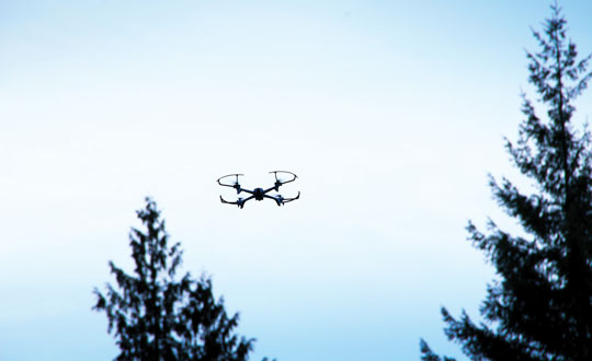

    Photo: ChristinaFelsing / iStock / Getty Images Plus / Getty Images
    Photo: ChristinaFelsing / iStock / Getty Images Plus / Getty Images

    UAVs to the rescue

    A child reported missing in Robbinsville, N.J., was found in less than 10 minutes using a UAV equipped with a thermal camera, WPVI reported.

    On the night of January 17, Robbinsville Police received a call reporting a missing child last seen running into a heavily wooded area. Officers dispatched the department’s UAV equipped with thermal imaging cameras, which allowed officers to quickly locate the missing boy through thick vegetation after dark. The child was unharmed, according to the report.


    Photo: Maxar Technologies
    Photo: Maxar Technologies

    Fire strikes Chile

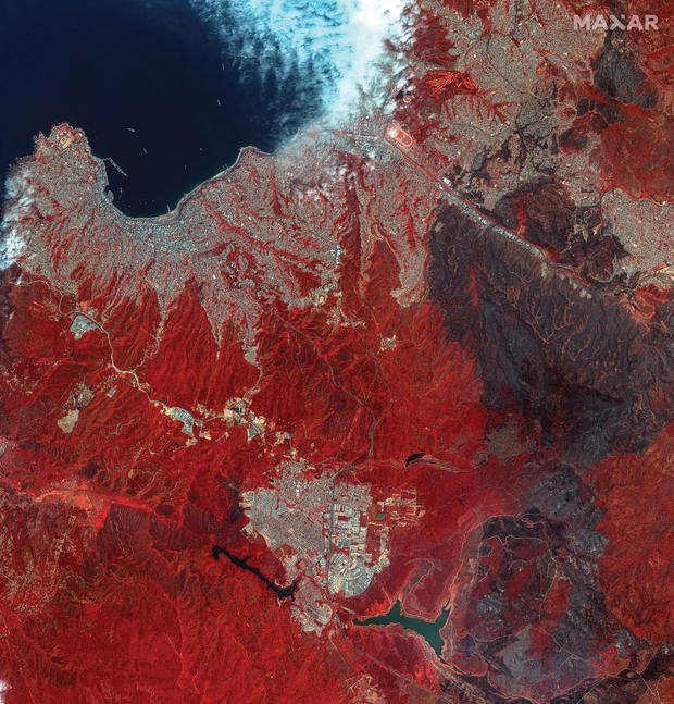
    Maxar Technologies has released satellite images showing the widespread damage caused by raging wildfires in Chile’s Valparaíso region. The fires have killed more than 122 people. The images show entire neighborhoods destroyed east of the resort town of Viña del Mar yet do not show active wildfires. The fires reportedly surged in the Valparaíso region, fueled by winds and an intense heatwave that has seen temperatures of around 40° C.


    Photo: seregalsv / iStock / Getty Images Plus / Getty Images
    Photo: seregalsv / iStock / Getty Images Plus / Getty Images

    No drones in the prison yard

    The UK government has introduced regulations establishing a 400 m UAV “no-fly zone” around prison facilities. The announcement addresses the escalating use of UAVs by criminals attempting to transport illicit items — including phones, drugs and weapons — into prisons.

    The initiative is a response to the increase in the number of UAVs detected or sighted within prison grounds, which more than doubled between 2019 and 2021, according to a press statement from the UK government. The implementation of “no-fly zones” aims to enhance law enforcement’s ability to catch organized criminals in the act. Additionally, these measures are designed to prevent illegal aerial filming of prisons.


    Photo: Bim / E+ / Getty Images
    Photo: Bim / E+ / Getty Images

    Back to the fields

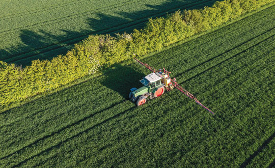
    GNSS jamming by the Israeli Defense Forces (IDF) has forced retired farmers in the Israeli settlement Mevo Hama to return to the fields. In an interview with CTech, local farmer Rami Laner shared that the younger equipment operators do not know how to operate the modern tractors for spraying or sowing tasks without the aid of their GNSS-based autonomous systems. With the IDF intentionally jamming and spoofing GNSS signals, civilians in the area are in search of alternative PNT systems to protect communities and maintain workflows.

  • PNT Advisory Board at 20:  Still serving up big ideas

    PNT Advisory Board at 20: Still serving up big ideas

    • Quickly prototype a GNSS interference detection and reporting system.
    • Implement an internet-based High Accuracy and Robustness Service (HARS)for GPS.
    • Relax export controls that currently restrict use of adaptive anti-jam antennas.

    These are just three of the efforts the U.S. government is pursuing as a result of recommendations from the President’s National Space-based Positioning, Navigation and Timing (PNT) Advisory Board.

    For 20 years the PNT Advisory Board has been providing the government independent expert advice about GPS and PNT.

    Established by presidential directive in 2004 and administered under the Federal Advisory Committee Act by NASA, its charter has been regularly renewed. The charter provides that the board shall:

    • Be composed of experts from outside the United States government.
    • Seek input from state and local governments, industry and academia on developments in the application of space-based PNT technologies.
    • Evaluate national and international needs for changes in space-based PNT capabilities and assess possible trade-offs among options.
    • Provide independent advice and recommendations to the National PNT Executive Committee (co-chaired by the Deputy Secretaries of Defense and Transportation) on policy, system requirements, and program needs.

    While “space-based” is in its name and charter, the board has long recognized that terrestrial assets also can play an important role in serving PNT users by augmenting, reinforcing, and complementing GPS. The use of complementary systems, for example, could help demotivate intentional jammers and spoofers and help safeguard users during any interference event. Thus, the board often considers a wide range of capabilities and systems.

    The board also discusses policy, education, international relations and other issues important to the PNT community. As one board member commented, “Technology doesn’t exist in a vacuum. It is developed by, and intended to serve, people. If you don’t recognize that, you are missing most of the picture.”

    The current board’s membership includes an impressive array of experts in PNT policy and technology. Its 29 members include a former governor, a retired admiral, three retired generals, GPS’ original chief architect, a former undersecretary, a former assistant secretary, three former presidents of the Institute of Navigation (ION), three international members and experts from across academia and industry.

    Chaired by former Coast Guard Commandant Admiral Thad Allen, the board’s primary efforts are driven by its six subcommittees, reflecting a holistic approach to effective PNT:

    • Strategy, Policy & Governance
    • Protect, Toughen & Augment
    • Emerging Capabilities, Applications & Sectors
    • Education & Science Innovation
    • International Engagement
    • Communications & External Relations

    While the subcommittees meet in fact-finding sessions to gather data, the PNT Advisory Board’s deliberations are public. Semi-annual meetings in  Washington, D.C. and other locations may be attended by anyone, either in person or virtually. Announcements on the board’s webpage and in the Federal Register provide details before each meeting. By law, the minutes of each meeting are available to the public, and video recordings of meetings are normally posted as well.

    Input from the public about PNT issues of concern is also welcome to inform the board’s current and future deliberations. Information on how to send input will be posted with the meeting announcement here

    According to board member Jeff Shane, former undersecretary at the U.S. Department of Transportation (DOT), the PNT Advisory Board is evidence of government at its best. “The very fact that the board was established underscores our government’s willingness to hear and consider the widest variety of views and input. It should be a source of optimism, and even pride, for the entire PNT community.”


    National Space-based PNT Advisory Board

    The next meeting will be from 9:00 a.m. to 6:00 p.m. MDT, April 24, 2024, and from 9:00 a.m. to noon April 25 at The Antlers Hotel in Colorado Springs, Colorado. Click here for information on a reception on April 23, featuring Gen. David Thompson.

  • SparkFun launches Iridium antenna

    SparkFun launches Iridium antenna

    Image: SparkFun Electronics
    Image: SparkFun Electronics

    SparkFun Electronics has released the 2J7426MPz by 2J antenna, a high-performance magnetic mount antenna designed to communicate with the Iridium satellite communication system. It is manufactured with high-quality polycarbonate (PC) and acrylic-styrene-acrylate terpolymer (ASA), a thermoplastic combination that offers strong resistance to UV, moisture, and heat and enhances mechanical properties.

    The antenna housing is waterproof to IP69 standards and designed to operate in extremely harsh environments, including those with frequent exposure to water, dust and debris. It has a recommended operational and storage temperature of -40°C to +85°C. The magnetic mount allows for easy installation and removal between vehicles or assets, and it is easily converted to an adhesive type for greater flexibility.

    It is delivered with a standard SMA-male connector and a standard 300 cm long coaxial LL100 cable. Iridium has certified the 2J7426MPz antenna for commercial use in connection with the Iridium communications system.

  • FrontierSI advances Australian PNT infrastructure

    FrontierSI advances Australian PNT infrastructure

    Image: FrontierSI
    Image: FrontierSI

    FrontierSI, a not-for-profit research organization specializing in positioning, geodesy, spatial infrastructures and rapid spatial analytics, has released a review of Australia’s resilient positioning, navigation and timing (PNT) policy to fortify the country’s PNT infrastructure. The review, expanded upon in a new white paper and technical report, was created in response to the increasing number of cyber threats.

    “PNT is an essential utility we presently have no control over,” said Joshua Critchley-Marrows, FrontierSI’s space PNT lead. “Australia’s access to PNT is intrinsically linked to satellite-delivered services from foreign-owned and operated assets, such as the USA’s Global Positioning System (GPS). Investing in our infrastructure is crucial to ensure continuous access to this critical service that underpins nearly all aspects of our daily lives.”

    According to FronteirSI, the reliance on foreign satellite systems exposes Australia to significant vulnerabilities, such as recent technological failures and cyber-attacks. These incidents emphasize the need for a self-reliant and robust PNT ecosystem capable of withstanding both unintentional and malicious disruptions.

    FrontierSI aims to bolster PNT resilience by enhancing the systems’ robustness against disruptions and advocating for the development of assured, robust, augmented and alternative PNT solutions. The recommendations outlined in the white paper and technical report call for proactive measures, including legislative updates and supply chain risk assessments, to protect Australia’s critical infrastructure and economic vitality.

  • First Fix: Very busy space

    First Fix: Very busy space

    Artist impression; size of debris exaggerated as compared to Earth. (Image: ESA)
    Artist impression; size of debris exaggerated as compared to Earth. (Image: ESA)

    So much going on up there!

    On Jan.11, speaking at a press briefing in Paris, Javier Benedicto, director of navigation for the European Space Agency (ESA), announced the agency had completed the procurement process for the low-Earth Orbit Positioning Navigation and Timing (LEO PNT) program. ESA expects to have the new LEO PNT demonstration satellites, which will broadcast signals over several frequency bands, up and running by 2026. A positive outcome will most likely lead to the procurement and deployment of a full European LEO PNT constellation for global services.

    Also in January, news broke that Google and two of the largest mobile network operators in the world, AT&T and Vodafone, had invested more than $200 million in AST SpaceMobile’s cellular broadband network based on LEO satellites and accessible directly by smartphones. AST SpaceMobile already operates the largest-ever commercial communications array in LEO, the BlueWalker 3 satellite, which, due to its size and brightness, is alarming astronomers.

    On Feb. 21, The New York Times reported about U.S. warnings to its allies that Russia might deploy a nuclear weapon in orbit this year. According to the paper, U.S. intelligence agencies told their closest European allies that, “if Russia is going to launch a nuclear weapon into orbit, it will probably do so this year — but that it might instead launch a harmless ‘dummy’ warhead into orbit to leave the West guessing about its capabilities.” A space weapon nested inside a satellite could destroy, jam, or otherwise disable dozens or hundreds of commercial and military satellites in LEO, such as the Starlink satellites that are revolutionizing global communications. See Dana Goward’s analysis.

    The next day, Tim Crain, chief technology officer of the Houston-based company Intuitive Machines announced, “Houston, Odysseus has found its new home.” For the first time since Apollo 17 in 1972, a U.S.-built spacecraft had landed on the moon. Odysseus, described by the Times as “a bit bigger than a telephone booth,” (which most people under the age of 20 have never seen), was later confirmed to be upright and sending images. It was delivered into lunar orbit by a SpaceX rocket. NASA hopes this mission will help inaugurate a new era of economical spaceflights around the solar system. Intuitive Machines is one of several small companies the agency has hired to transport instruments to reconnoiter the surface of Earth’s only natural satellite in preparation for the return of NASA astronauts.


    My highly synthetic description of the Federal Aviation Administration (FAA) aircraft tracking systems in last month’s First Fix was a bit muddled. Fortunately, I can count on our Editorial Advisory Board member Mitch Narins to clarify:

    FAA systems determine an aircraft’s position using a combination of independent and dependent surveillance. Independent surveillance does not require the “cooperation” of the aircraft (e.g., primary radar), while dependent surveillance requires the aircraft to either respond to an interrogation signal or periodically transmit its position — e.g., Automatic Dependent Surveillance-broadcast (ADS-B).

  • Scientific Systems advances navigation software

    Scientific Systems advances navigation software

    Image: Scientific Systems
    Image: Scientific Systems

    Scientific Systems has released upgrades for ImageNav, an image-based navigation software designed for GPS-denied or compromised environments.

    With more than a decade of development, ImageNav offers a robust alternative to traditional GPS navigation for military operations, particularly in contested environments where jamming poses a threat to GPS reliability.

    The demand for such technology has become increasingly critical considering enhancements to electronic warfare capabilities, with instances of GPS signal disruption impacting military assets. ImageNav is designed to address GPS vulnerability by offering precise navigation for a wide range of systems, including weapons, aircraft and uncrewed aircraft systems (UAS), without reliance on GPS signals.

    ImageNav uses an onboard electro-optical (EO) or infrared (IR) digital camera and can employ three algorithms to analyze captured images and correlate them with stored terrain and image references. This process allows both absolute and relative navigation position updates. The technology can be integrated into air platforms as a software upgrade or as part of a self-contained hardware payload, minimizing size, weight and power (SWaP) requirements.

    Scientific Systems is actively pursuing the integration of ImageNav onto GPS-guided munitions and UAS to operate in environments where GPS access is denied. Recent testing has demonstrated the technology’s capability to navigate without GPS and hit targets within required performance parameters.

  • DOT issues solicitation for CPNT services

    DOT issues solicitation for CPNT services

    Photo:

    The Volpe National Transportation Systems Center of the U.S. Department of Transportation (DOT) has issued a solicitation to obtain proposals from vendors with operationally ready complementary positioning, navigation and timing (CPNT) services to be used for testing and evaluation in the Rapid Phase of the DOT’s CPNT Action Plan.

    The Volpe Center is seeking proposals from industry professionals to deploy PNT services with a technical readiness level (TRL) of eight or higher.

    The evaluation conditions will include situations where GPS/GNSS service is disrupted or manipulated, and CPNT‐specific threat vectors are introduced. Proposals are encouraged to be tailored to critical infrastructure PNT user requirements with the expectation that Rapid Phase evaluation results will be shared with sector risk management agencies (SRMAs) through the Federal interagency process to drive CPNT adoption.

    According to the Volpe Center, it is prepared to make multiple awards if multiple proposals meet the solicitation requirements.

    Responses to the request for quotation (RFQ) should include the bidder’s preferred test range model(s) out of the following three proposed models, where the proposed CPNT service can quickly become operationally ready to meet the Rapid Phase timeline objectives — no later than six months after award:

    1. Federal Government‐hosted test range
    2.  Critical infrastructure test range
    3. Vendor-fielded test range

     Offers are due March 25, 2024. Click here for more information.

  • BlueSpace.ai launches AI-powered solution for GPS-denied environments

    BlueSpace.ai launches AI-powered solution for GPS-denied environments

    Image: Stanford Engineering GPS lab
    Image: Stanford Engineering GPS lab

    BlueSpace.ai, a Silicon Valley-based company specializing in off-road and unstructured autonomy, has released its assured positioning, navigation, and timing (A-PNT) solution. The solution — called BlueSpace Positioning Solution (BPS) — illustrates how artificial intelligence (AI) can enhance navigation precision in GPS-denied and GPS-degraded environments for both manned and unmanned vehicles.

    BPS is designed to address the challenges posed by weak GPS signals, susceptible to jamming, spoofing and unintentional blockages in various environments. It can support a cross-track error, or drift error, of less than 0.3%. This surpasses the industry standard of approximately 1% error over distance traveled. BPS also aims to maintain high performance while using industrial-grade inertial measurement units (IMUs), which leads to improvements in size, weight and power (SWaP).

    The AI solution is designed to eliminate geofence limitations and remove dependencies on prior training data and ultra-HD mapping.

    BlueSpace.ai has participated in a variety of defense and commercial applications, including applications in challenging underground mining environments, truck and bus automation and off-road autonomy.

  • Point One Navigation expands Polaris RTK location network to South Korea

    Point One Navigation expands Polaris RTK location network to South Korea

    Image: Point One Navigation
    Image: Point One Navigation

    Point One Navigation has expanded its Polaris real-time kinematic (RTK) location network to South Korea.

    The network is set to provide comprehensive coverage throughout the country. Existing Polaris customers can use the South Korean integration to enhance the precision and efficiency of their location-based projects.

    Polaris offers centimeter-level accurate GNSS positioning with accuracy ranging from 1 cm to 10 cm, which makes it ideal for challenging environments, such as urban areas with limited sky view. Unlike standard GNSS systems — which face position uncertainty due to atmospheric signal delay, satellite orbit variation, clock drift and signal multipath — the Polaris network counters these issues using additional information from compact base stations.

    Point One’s FusionEngine software further integrates inertial measurement, wheel odometry and additional sensors to achieve the desired level of precision in the complete absence of satellite signals.

    The Polaris network with FusionEngine software can be used as a precision location service for autonomy and robotics applications. Polaris supports all major GNSS constellations and has an extremely dense global network of base stations that cover the United States, Europe, New Zealand, South Korea, and parts of Canada and Australia.

    Developers can integrate the Polaris RTK network and FusionEngine software using GraphQL API. The network can be built into demanding applications such as industrial autonomy, precision agriculture, logistics and delivery, robots and advanced driver-assistance systems (ADAS).

  • Integrating and developing GPS technology

    Integrating and developing GPS technology

    Image: Northrop Grumman
    A flight test of Northrop Grumman’s airborne navigation solution, embedded GPS/INS modernization, EGI-M (Image: Northrop Grumman)

    What was Northrop Grumman’s GPS Origin Story?

    Northrop Grumman’s involvement with GPS has its origins during the mid-1980s, when we became an early adopter. We applied our prior decades of technical expertise in defense and commercial navigation solutions to recognize the significance of GPS as an emerging technology to optimize our inertial navigation products. The first GPS receiver was integrated with the LN-33, our main product for military aircraft, in 1987.

    Around the same time, our engineers began to develop an indigenous civil GPS receiver to complement our inertial navigator for use in commercial airliners. This resulted in the certification and fielding of the LTN-2001 product, an eight channel C/A Code GPS receiver. This receiver, in concert with our Autonomous Integrity Monitored Extrapolation (AIME) algorithm, provided our customers a first-ever sole means navigation system using GPS/inertial for non-precision approach.

    By the early 1990s, advancements in the semiconductor industry facilitated the reduction of the GPS receiver from a 1,000 cu in stand-alone box to a roughly 6-in by 6-in circuit card. This critical milestone allowed GPS to be embedded into an inertial navigation system (INS) without a significant increase in its size or power consumption and thereby the ubiquitous Embedded GPS INS (EGI) was born. Our first inertial navigation system with embedded military GPS capability was the LN-100G in 1991. This standard form factor was produced across the industry with installations on virtually all the front-line tactical aircraft and rotorcraft for the U.S. Department of Defense (DOD) and many of our allies.

    Can you share a breakthrough?

    Inspired by accomplishments in the survey community, our team conducted early location accuracy experiments to demonstrate a few decimeters of accuracy between our Woodland Hills, California, location and a facility in San Jose, California, about 500 km away. Leveraging this experience and the same signal processing, our teams became a broader solution provider for adjacent mission applications including precise formation flying for in-flight automated refueling, precision approach and landing, and decimeter-level positioning for the intelligence, surveillance and reconnaissance (ISR) community.

    LN-100G. (Image: Northrop Grumman)
    LN-100G. (Image: Northrop Grumman)

    In parallel with these developments, Northrop Grumman, in partnership with the Defense Advanced Research Projects Agency (DARPA), improved the resilience of embedded GPS receivers with a more intimate coupling of INS and GPS. The DARPA GPS Guidance Package (GGP) program demonstrated a Navigation Grade Fiber Optic Gyro (FOG), greatly improved GPS tracking performance under extreme vehicle dynamics, and the ability to track at lower signal-to-noise levels. Our success on this program reinforced our reputation as a GPS integration leader and led to the introduction of Northrop Grumman’s current LN-251 product line, which is broadly used in tactical military aircraft.

    In the early 2000s, Northrop Grumman initiated research into the feasibility of a Global Navigation Satellite System (GNSS) software-defined radio and started development of what we now call SERGEANT (Software Enabled Reconfigurable GNSS Embedded Architecture for Navigation and Timing). The company used Spirent signal simulators to evaluate proper GPS M-code tracking over a wide range of test cases in a controlled laboratory environment. Together with the Air Force Research Laboratory (AFRL), Northrop Grumman demonstrated advanced receiver capabilities using SERGEANT starting in 2010. In 2018, AFRL used SERGEANT for the first real-time flight demonstration of a GPS M-code SDR.

    How is your company preparing for the next 50 years of PNT with GPS and beyond?

    SERGEANT Flight Test SDR. (Image: Northrop Grumman)
    SERGEANT Flight Test SDR. (Image: Northrop Grumman)

    Northrop Grumman foresees the world of GNSS being dramatically influenced by the emergence of alternative radio navigation sources as augmentations to traditional GNSS constellations to provide additional robustness and resilience. Our PNT SDR technology is a foundational tool to integrate these emerging radio navigation signals quickly and accelerate deployment to our customers.

    Northrop Grumman has led medium-Earth orbit (MEO) and low-Earth orbit (LEO) PNT technology studies through the DARPA Blackjack proliferated LEO (pLEO) program, starting in 2017. Northrop Grumman’s SERGEANT SDR transceiver is currently being integrated for use in emerging pLEO constellations. We anticipate that these capabilities, as well as emerging cooperative radio navigation signals, will become a critical part of the next 50 years of PNT with GPS.

  • From testing GPS to assuring PNT

    From testing GPS to assuring PNT

    A Spirent user employs a portable GSS6450 attached to an antenna to record GPS, other GNSS, and complementary signals for resilient PNT testing. (Image: Spirent)
    A Spirent user employs a portable GSS6450 attached to an antenna to record GPS, other GNSS, and complementary signals for resilient PNT testing. (Image: Spirent)

    What is Spirent’s GPS origin story?

    Spirent’s GPS genesis began on a rooftop in the middle of the night in the early 1980s. Engineers were attempting to acquire the new GPS signals with their receivers, scheduling their lives around the times when satellites would pass overhead, angling antennas off a roof in the dark, and hoping for favorable conditions. Those difficulties inspired an idea: since real-world conditions are never the same twice, simulating the signals in a lab would control variables and provide repeatable and trustworthy results.

    That idea grew to be Spirent’s positioning division — a team of experts whose sole focus is to partner with customers to accelerate the deployment of robust PNT technology. In 1985, one of the first groundbreaking simulators provided to a customer generated six GPS L1/L2 signals. Soon after, we developed the world’s first simulator with SA-A/S capability, establishing our reputation for innovation. Today, simulation is for much more than convenience. The further upstream testing starts, the better for R&D and investment decisions. Because of that, we work across the spectrum in close partnership with constellation developers, receiver manufacturers, and OEM application integrators.

    Can you share a recent breakthrough?

    GPS regional military protection (RMP) is a nascent anti-jamming capability that uses a steerable, narrow-beam M-code signal, allowing U.S. and allied forces to operate much closer to interference without losing connection. Spirent supports RMP, so modernized GPS user equipment (MGUE) can be tested and integrated with RMP long before live-sky signals are available.
    Another major breakthrough is in AltNav, a catch-all term that includes non-GNSS sources of RF and other complementary PNT, with recent attention focused on low-Earth orbit (LEO) constellations. Spirent has developed LEO AltNav simulators for both the military and commercial sectors that seamlessly integrate with Spirent’s extensive testbed for GNSS, threat simulation, inertial navigation systems, and additional complementary PNT.

    How is your company preparing for the next 50 years of PNT with GPS and beyond?

    As a trusted industry test partner, one of Spirent’s guiding principles over the past five decades has been to support PNT developers and early adopters by being first-to-market with new signals and constellations. Enabled by our flexible solutions, our dedication to that tenet will continue across the next five decades.

    NAVWAR resilience testing is an area where emerging test needs will continue to demand more from the test environment. Layered PNT positioning engines — including GNSS, secure military signals, CRPA systems, multi-orbit architectures, and sensor fusion — are driving complexity in the test regimes that support them. Spirent’s purpose-built solutions are designed to meet these advancements, with deterministic simulation that delivers definitive validation and accurate test results.

    Spirent pioneered the use of software-defined radios for GNSS simulation with the GSS9000, which enabled the same architecture to support new signal types, higher motion rates, user-defined waveforms, and more than double the generated signals. The next generation will extend that flexibility, capacity, and ease of integration to future complementary PNT sources while maintaining system performance across physical and virtual realms.

  • TRX Systems DAPS GEN II system now shipping to U.S. Army

    TRX Systems DAPS GEN II system now shipping to U.S. Army

    Image: TRX Systems
    Image: TRX Systems

    TRX Systems has announced it is now shipping the Dismounted Assured Positioning, Navigation, and Timing (PNT) System Generation II (DAPS GEN II) solution to the United States Army. The device provides assured PNT to warfighters operating in GPS-denied environments. 

    In March, the U.S. Army Program Executive Office for Intelligence, Electronic Warfare and Sensors awarded TRX a seven-year, $402 million contract to deliver the DAPS GEN II systems 

    TRX DAPS GEN II is a small, handheld device that features efficient power utilization algorithms that enable a continuous stream of assured PNT data for warfighters and their combat systems. To achieve this, the device fuses inputs from a diverse range of PNT sources including M-code GPS, a secure and higher-powered military GPS capability that is resilient against jamming and other threats, complementary sources of position and time data when GPS is degraded, and inertial sensors supporting integrity and positioning, independent of any satellite source. 

    The TRX DAPS II system is available for purchase by U.S. government entities. Distribution to U.S. allies is restricted to approved cases in the Foreign Military Sales Program.