The webinar, sponsored by Nearmap, takes place June 25 at 1 p.m. EDT / 10 a.m. PDT / 7 p.m. (1900h) Central European Time. Registration is free.
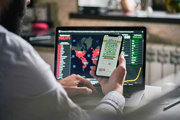
Managing and protecting the nearly 31,000 acres of the preserves is no small task, so the ability to see the environment at scale in crystal-clear clarity is a must. Aerial imagery provides an “eye in the sky” to get better context of truth on the ground.
Lake County Forest Preserves uses Nearmap aerial imagery to:
monitor and track change over time with historical and current captures
assess and address invasive species growth with high-resolution imagery
manage remote work challenges during COVID-19 to locate assets.
Joining Brett Clark of Nearmap are three experts from Lake County Forest Preserves.
Nick Spittlemeister GIS Analyst, Planning and Land Preservation Dept. Lake County Forest Preserves District (IL)
Nick Spittlemeister has been with Lake County Forest Preserves since 2016, working to create an enterprise solution that employs web GIS in all facets of the organization. He helped the district secure a license with Nearmap in 2018 and has deployed it across their GIS system, from Desktop software to web applications and native apps. He has been using GIS for more than 15 years and holds a bachelor’s degree in geography from Northern Michigan University.
Dave Cassin Manager of Landscape Ecology Lake County Forest Preserves District (IL)
David Cassin’s remote sensing training began in the US Navy (1990-94) where he was trained as an Intelligence Specialist / Air Photo Interpreter, put into practice during Operation Desert Shield / Storm. Post military service, he continued his craft in college with incorporation of ArcGIS. He combined his skillset and his love of nature by getting a degree in Natural Resource Management. Integrating remote sensing skills into landscape scale restoration projects by utilizing historical air photos and land survey data, he is able to determine historic land uses and alterations. Specific to Nearmap, he was able to map populations of Phragmites australis (an invasive species in Illinois) by utilizing the fall 2019 Nearmap imagery remotely during the COVID-19 stay at home order.
Kevin Kleinjan Senior Engineer Lake County Forest Preserves District (IL)
Kevin has utilized aerial imagery and geospatial technologies for over 25 years to inform and support planning and infrastructure related decisions. He utilizes Nearmap’s high-resolution imagery with multiple captures throughout a calendar year to analyze and update infrastructure assets quickly and accurately from both the office, and in the field using mobile devices. This enables him to efficiently manage the District’s sign shop, site amenity and heavy equipment crews. He has dual degree in Landscape Architecture and Geography from South Dakota State University and is a Registered Landscape Architect in Illinois and Wisconsin.
Brett Clark Senior Account Executive Nearmap Brett graduated from Brigham Young University with a degree in communications. He was employee #2 for Nearmap, U.S., and focuses primarily on serving the public sector – both state and local. Brett lives in the Indianapolis area with his wife and three daughters.
HoverGames Challenge 2: Help Drones Help Others is the second installment of NXP’s challenge-based, interactive coding competition. It encourages developers to create drone and rover solutions for frontline support during pandemics.
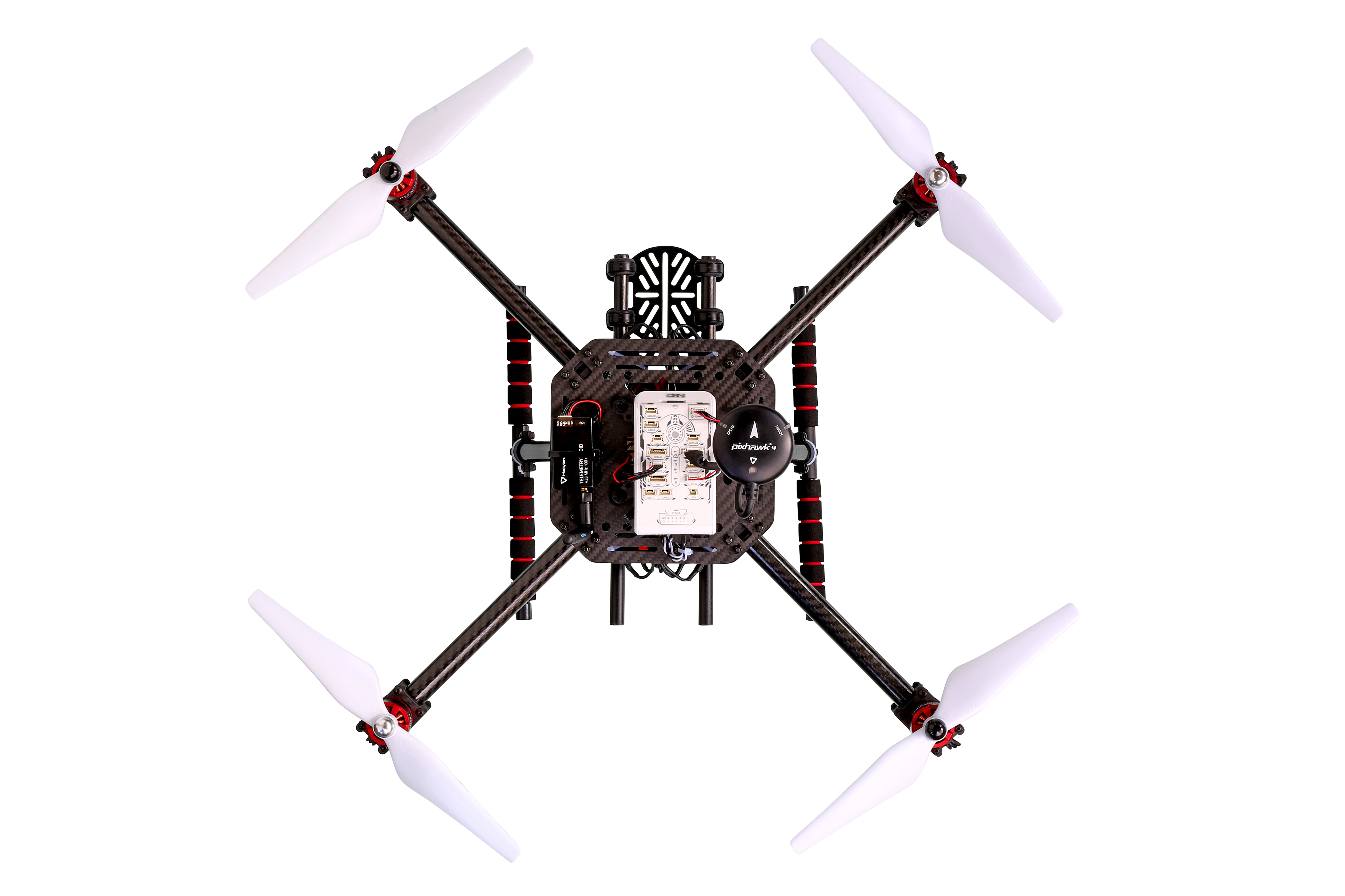
A carbon-fiber quadcopter frame is included in the developer’s kit. (Photo: NXP)
Participants will leverage NXP’s broad portfolio of automotive, industrial and IoT technologies for system control, networking, security and motor control to create solutions that can make a difference in pandemic response.
The first HoverGames took place in the summer of 2019, and was centered around firefighter response. Read about it here.
The collateral effects of pandemics leave citizens with difficult challenges to overcome. A lack of mobility, social isolation and lack of access to goods and services can be physically and psychologically devastating.
HoverGames Challenge 2 will inspire participants to develop pioneering ways to use drones to help healthcare and frontline workers overcome these barriers. The competition encourages contestants to consider the full scope of the difficulties facing society during a pandemic, apply new learning, and work cooperatively through the development of open-source code and community-tested projects to create solutions that help society prepare for future challenges.
Deadline for application is July 31. The competition closes Nov. 30, and winners will be announced in December.
Drone Developer Kit. The hardware and software of this year’s developer kit remains open, flexible and modular. The flight management unit (RDDRONE-FMUK44FMU) includes professional, automotive and industrial-grade components enabled by the PX4 flight stack. PX4 is a large commercially deployed open source flight stack and supports contemporary airframe architectures including vertical-takeoff-and-landing (VTOL) aircraft, multicopter and rover profile.
The kit also includes a strong, rigid, lightweight carbon-fiber quadcopter frame with platform, mounting rails, landing gear, motor controllers, motors and props as well as telemetry radio and remote-control radio.
This year’s kit will contain a bonus extension component, the NavQ, an i.MX8M Mini Vision development board.
Projects and lessons learned are transferable to real-world enterprise and commercial applications thanks to Auterion, the company that builds the enterprise distribution of PX4 for the commercial drone market.
“The current pandemic has exposed our vulnerability to disease and the general structural breakdown that can occur during a crisis,” said Iain Galloway, drone program lead, Systems Innovation, NXP. “But we don’t have to feel powerless in its wake. We can harness technology to make a difference. We invite you to leverage a complete functional system of hardware and software for drone and rover development and to share your creative solutions.”
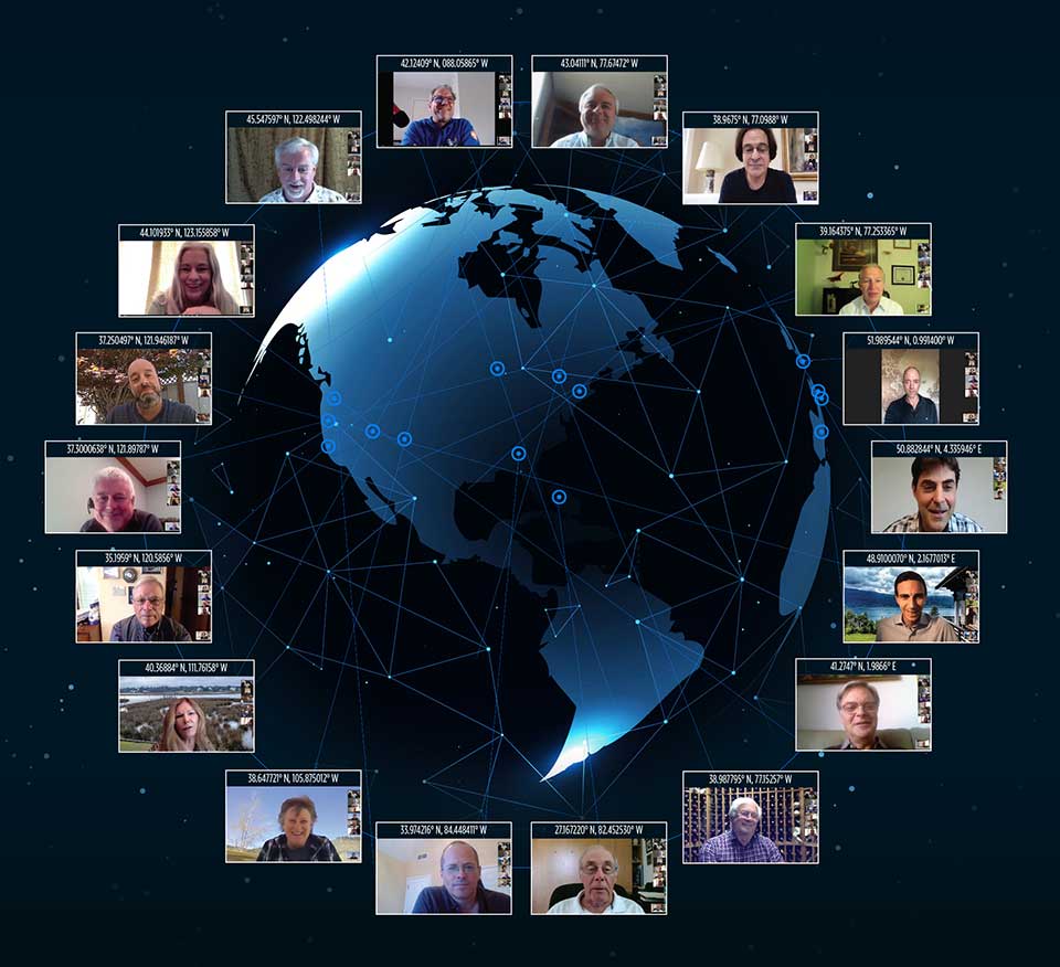
Reaching ’round the world: GPS World staff engage in a teleconference with Editorial Advisory Board members and contributors via teleconferencing. Clockwise from top: Tim Burch, John Fischer, Mitch Narins, William Tewelow, Julian Thomas, Jean-Marie Sleewaegen, Thibault Bonnevie, Ismael Colomina, Michael Swiek, Tony Murfin, Miguel Amor, Alison Brown, Ellen Hall, Brad Parkinson, Stuart Riley, Greg Turetzky, Tracy Cozzens and Matteo Luccio. (Photos: GPS World)
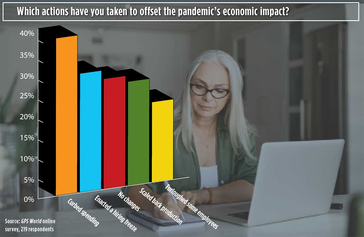
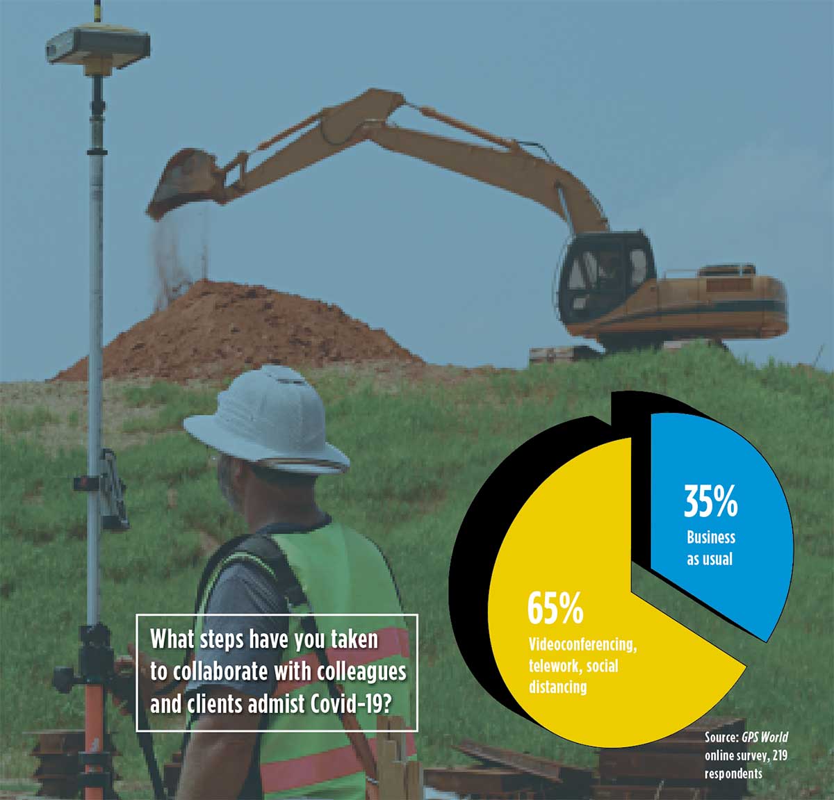
Our readers participated in an online survey on how they are being impacted by and responding to the COVID-19 pandemic. We summarize your responses here.
In April, GPS World asked its readers how the COVID-19 pandemic is affecting the GNSS/PNT industry and their day-to-day work.
About three quarters of respondents fell into two general areas of work: commercial (43%) and government/civilian (33%).
The three biggest market sectors primarily served by respondents’ companies are survey and construction (28%), defense and government (20%), and mapping and geographic information systems, or GIS (14%).
Because of the critical need for mapping during the pandemic, almost all mapping and GIS respondents said they have adapted to answer the needs of those seeking information about the coronavirus pandemic.
Supporting Solutions
About 14% of respondents reported their company has provided products or services for an application, project or customer directly tied to a COVID-19 response. These include support for police and government supervision, government and federal agencies’ emergency vehicles, air transportation, as well as medical supply transport.
Other efforts include ramping up the manufacturing of personal protective equipment such as face shields, with plants repurposed; others donated face masks, disinfectant and money. Also playing a supporting role are IT- and statistic-related services.
Tracking COVID-19. GNSS services provided by our readers to help track the virus include helping multiple agencies monitor traffic to and from critical locations, and building online dashboards for state data and surveillance.
“Our ability to provide GPS network services has enhanced the ability of public- and private-sector surveyors to continue working, to stay employed during these difficult economic times,” said one respondent.
Roadblocks. During the coronavirus pandemic, only 14% said they are significantly challenged to access parts and services, while 41% noticed a slowdown in deliveries. Comments included: “There have been issues getting supplies to set up for telework” and “Some international suppliers are having issues, so we are looking into alternative suppliers.”
Glass Half-Full
While there’s no question the COVID-19 outbreak has presented challenges, many respondents shared positive experiences while working in this current environment.
Working Remotely. For many of us, learning how to work remotely has been a positive experience, providing options that were overlooked or not considered before. Many readers were pleasantly surprised by how easy the transition has been and how well it has worked.
“It’s been a smooth transition to telework and production continues at normal rates,” said one respondent.
Others reflected on their successful adaptability with remote working, with comments such as “We have proven we can function with staff working remotely,” and “It brings people together in new ways!”
“As the team manager, I was fortunate that I had been transitioning my staff to be flexible in their work locations by replacing their desktop computers with notebook computers, enforcing the utilization of shared network resources for project data, and making sure IT systems were working for them — at work, in the field, and at home — prior to the pandemic. This has given me confidence in part-time telework for this group.”
Employees have become “more focused and more productive in necessary areas: documentation, contracts and gaining necessary certifications and contract information.”
Working from home also has improved productivity with fewer meetings and no commuting. “Traffic in any case was horrific.”
Rise of the Machines. Other respondents looked even further to the future. “COVID-19 has given companies and people a wake-up call. The new economy and new dynamics of workforce management will never be the same. This will help us tremendously as we approach AI (artificial intelligence) automation.”
No More Backlogs. While work has slowed in many areas, that cloud can have a silver lining. “It has allowed a backlog of work to be caught up, but we expect that will be temporary as business begins to bounce back.”
Finally, some respondents noted the human factor coming to the fore, including improved hygiene, seeing people help each other, and “more compassion for people in general.”
Photo: Photo: ftwitty / E+ / Getty Images
Where Do We Go from Here?
We asked our readers if coronavirus pandemic-related workflow changes and adaptations have brought about innovations they intend to keep going forward.
Many readers commented that increased reliance on working at home and new digital workflows will continue past the end of the pandemic. Online communication tools cited include email, WhatsApp, Skype, Teams and Zoom. “Knowledge and use of these tools are now ubiquitous,” wrote one respondent.
Others commented that traveling for meetings will be less frequent and reliance on videoconferencing will increase.
Staying Home. Companies plan to continue with at least some staff working from home to reduce their office-space spending. “I will probably have my staff telework two days per week once this pandemic passes. We will have more online training modules prepared. Digital signatures will be the norm.”
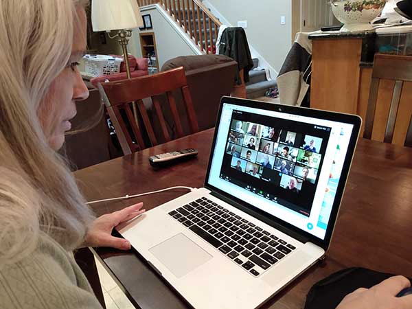
Senior Editor Tracy Cozzens Zooms from her home. (Photo: Steve Cozzens)
One respondent wrote, “We intend to keep using the digital workflow. Accepting and returning PDF plat reviews has worked very smoothly.”
“We are redesigning the logistics of how our business operates — decentralized versus centralized. In this new landscape, businesses cannot be tied to one central location,” another reader wrote.
Others are taking part of the new workflow back to the office: “Videoconferencing has taken on a new light. It works well, and will continue even after we move back to the office.”
Some had a steeper adaptation curve: “As a state government agency, we were not prepared to have the majority of staff working remotely, so we have had significant IT issues.”
Staying Healthy. “We will increase cleaning and sanitizing routines, and all employees and guests will have their temperatures taken before entering, and while on property,” commented one reader.
“The world has changed, and how these changes will affect our business has yet to be determined.”
A Look at Surveying
Surveying companies have adopted remote-office connection strategies and new ways to exchange digital and physical information with their field crews.
About two thirds of professional surveyors have taken steps such as working remotely and videoconferencing to collaborate with colleagues and clients. One respondent said, “We quickly pivoted to working from home by utilizing WebEx and Google Hangouts for collaboration.”
Out in the Field. Some firms are limiting one person per vehicle when traveling to work sites. “Drafting is done via work-from-home on laptops.” Field crews now typically are a single person using GPS and communicating via email.
Going Digital. “The paperless agenda that was difficult to institute is now in place and operational,” commented one surveyor. “It’s often difficult to change until we get that nudge.”
The non-profit 211 LA County and Slingshot Aerospace have unveiled an online mapping tool that allows users to quickly identify and locate more than 2,000 food resources within the county during and after the COVID-19 pandemic.
211 LA County is a non-profit organization providing the official information and referral source for health and human services in LA County. Slingshot Aerospace is a situational intelligence platform company,
The customized tool, called 211 LA FoodFinder, is powered by Slingshot Earth and is the biggest and only food map that allows LA residents to search for resources by location and view services specific to seniors, children and others, enabling individuals to find aid near them faster. Resources within the FoodFinder are free, with the exception of those with suggested donations or delivery service fees.
LA County residents will be able to identify different types of available food resources, such as child nutrition, meal services, groceries/food pantries, senior food needs and government food benefits programs.
The platform also provides location details, hours of operation and contact information for each of the services. 211 LA County is currently experiencing a tenfold increase in website traffic related to food resources compared to pre-COVID timeframes.
The organization anticipates the robust application to service nearly 30,000 LA County constituents over the next quarter, many of which may not have prior experience with food assistance.
“Food resources are the biggest need people are contacting us about since the COVID-19 pandemic hit LA County,” said Maribel Marin, executive director, 211 LA County. “With so many people out of work, the need for food is going to get progressively more intense, but people shouldn’t worry because there are lots of resources and ways to access them. Our custom Slingshot Earth food locator provides our community with a one-stop-shop for food resource information, helping to provide peace of mind to those who need food assistance during this unprecedented time.”
211 LA County’s customized Slingshot Earth mapping tool aggregates food resources and service data from multiple public and private sources so that individuals have the right information, at the right time, all in one place. The data is verified and updated regularly to ensure that Los Angeles County residents have the most up to date information as guidelines and offerings continue to evolve.
“This work to help 211 LA County provide critical food service information in our community is so meaningful to us because we are driven by a vision to create a safer, more sustainable world,” said Mel Stricklan, Co-Founder and Chief Strategy Officer, Slingshot Aerospace. “Our business was founded on the idea that information is power, especially in complex situations. The COVID-19 pandemic is uncharted territory for all of us, and we are happy to do our small part in navigating these tough times by providing essential information to those who need it most.”
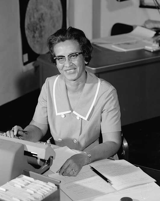
The United States Space Force’s GPS III program reached another milestone with the successful core mate of GPS III Space Vehicle 08 at Lockheed Martin’s GPS III Processing Facility in Waterton, Colorado, April 15.
With core mate complete, the space vehicle was named in honor of NASA trailblazer and “hidden figure” Katherine Johnson.
The two-day core mate consisted of using a 10-ton crane to lift and complete a 90-degree rotation of the satellite’s system module, and then slowly lowering the system module onto the satellite’s vertical propulsion core. The two mated major subsystems come together to form an assembled GPS III space vehicle.
Despite the COVID-19 pandemic, the Space and Missile Systems Center (SMC) and its mission partner Lockheed Martin ensured that SV08 core mate took place, in accordance with all Centers for Disease Control and local guidelines to minimize exposure or transmission of COVID-19. The GPS III Processing Facility’s cleanroom high bay was restricted to only key personnel directly supporting the operation.
“Core mate is the most critical of the GPS space vehicle single-line-flow operations,” said Lt. Col. Margaret Sullivan, program manager and materiel lead for the GPS III program. “Despite the restrictions presented by the COVID-19 pandemic, our team adapted and worked tirelessly to achieve this essential milestone.”
Katherine Johnson. (Photo: NASA)
Katherine Johnson. When the core mate operation is successfully completed, a GPS III satellite is said to be “born.” In keeping with the team’s tradition of naming GPS III satellites after famous explorers and pioneers, SV08 was named “Katherine Johnson” in honor of the trailblazing NASA mathematician and “human computer” who designed and computed orbital trajectories for NASA’s Mercury, Apollo and space shuttle missions.
One of four African-American women at the center of the nonfiction book by Margot Lee Shetterly and the movie Hidden Figures, Johnson was awarded the Presidential Medal of Freedom in 2015 for her groundbreaking contributions to the U.S. space program.
Other GPS III satellites have been named in honor of explorers including GPS III SV01 “Vespucci” after Amerigo Vespucci; GPS III SV02 “Magellan” after Ferdinand Magellan; and GPS III SV03 “Columbus” after Christopher Columbus.
Next up, performance tests. The next step for the newly christened “Katherine Johnson” is the post-mate Systems Performance Test (SPT) scheduled to begin in August. SPT electrically tests the performance of the satellite during the early phase of build and provides a baseline test data set to be compared to post-environmental test data.
GPS III SV08 is currently scheduled to launch in 2022.
The Mobile Service Tower rolls back from the ULA Delta IV rocket carrying the GPS III SV02 satellite in preparation for launch. (Photo: ULA)
GPS III is the most powerful GPS satellite ever developed. It is three times more accurate and provides up to eight times improved anti-jamming capability over previous GPS satellites on orbit. GPS III brings new capabilities to users as a fourth civilian signal (L1C), designed to enable interoperability between GPS and international satellite navigation systems, such as Europe’s Galileo system.
GPS III satellites will also bring the full capability of the Military Code (M-code) signal, increasing anti-jam resiliency in support of the warfighter. These continued improvements and advancements to the GPS system makes it the premier space-based provider of positioning, navigation, and timing services for more than four billion worldwide.
GPS III SV03 is scheduled to launch on June 30.. (Photo: Lockheed Martin)
GPS III SV03 to Launch June 30. Launched in December 2018 and August 2019, GPS III SV01 and SV02 became part of today’s operational constellation of 31 satellites, on January 13 and April 1, 2020 respectively. GPS III SV03 is scheduled to launch on June 30.
The SMC, located at the Los Angeles Air Force Base, California, is the center of excellence for acquiring and developing military space systems. Its portfolio includes the GPS, military satellite communications, defense meteorological satellites, space launch and range systems, satellite control networks, space based infrared systems, and space situational awareness capabilities.
Skyports’ delivery drone, manufactured by Wingcopter, takes flight. (Photo: Wingcopter)
Skyports and Thales are partnering to conduct a drone delivery trial for the National Health Service (NHS) to support the United Kingdom’s COVID-19 response.
The trial, being conducted in Scotland, aims to prove the feasibility of delivering urgent medical cargo, such as COVID-19 test kits and Personal Protective Equipment (PPE), between remote medical facilities by delivery drone. The trial is backed by Argyll and Bute Health and Social Care Partnership (HSCP) — the integrated partnership of NHS Highland and Argyll and Bute Council directed by the local Integration Joint Board.
U.K. drone delivery provider Skyports will conduct the trial and operate the flights using delivery drones supplied by unmanned aircraft-maker Wingcopter, because of its proven capability through numerous delivery operations around the world. The trial flights will be planned through Thales’ drone operations management platform, SOARIZON, which offers digital tools to maintain compliant and safe drone flying operations.
Based at Lorn and Islands Hospital in Oban, the trial will consist of two-way flights between the hospital and Mull and Iona Community Hospital in Craignure 10 miles (16km) away on the Isle of Mull.
As COVID-19 testing rapidly gathers pace in the U.K., the proposed delivery service will help to ensure that isolated communities have access to tests, delivered in a fast and efficient way. Currently, the majority of medical supplies and specimens are transported between the laboratory at Lorn and Islands Hospital, surrounding general practitioners’ surgeries and other healthcare settings by sea and road, a long and complicated journey.
The service would cut delivery times from up to six hours one way by ground transport and ferry, to 15 minutes for on-demand delivery by drone. The speed would contribute to keeping front line medical and delivery personnel safe.
Answering the call from government and Argyll and Bute HSCP, in response to the COVID-19 crisis, the trial is the result of rapid mobilization from industry as well as the Civil Aviation Authority (CAA), local government, NHS Scotland and the U.K. Department for Transport (DFT). Argyll and Bute HSCP has been at the forefront of exploring with Skyports the use of unmanned aircraft technology, building on preliminary work with the Scottish government on the possibility of drone use by the public-sector emergency services in Scotland.
The two-week trial represents a crucial milestone for unmanned aviation in the U.K. Under current rules, drones must always be flown within visual line of sight of the remote pilot. To undertake these more extended flights (beyond visual line of sight, or BVLOS), the project team has been in close consultation with the CAA.
Through this trial, the alliance aims to prove the long-term, sustainable viability of such services; bringing together regulation, government and industry to unlock the transformational potential of drones for society when used in a safe, secure and controlled way.f this new service.”
Thales and Skyports are also working together within the CAA Regulatory Sandbox programme, exploring how regulatory approvals can be granted for more widespread BVLOS drone operations in the U.K.
Once the trial has been successfully completed, the team will continue to work closely with the CAA and the NHS to make services available in Scotland and across the U.K. to provide access to this innovative technology to a wide range of organisations, in particular a number of other NHS Boards and Trusts.
Driven by COVID-19, the uptick in adoption supports collaboration among remote workers as businesses adapt.
The Trimble Connect cloud-based collaboration platform has surpassed 10 million users. In response to COVID-19, distributed working has intensified the need for teams to share information and collaborate remotely, leading 1.2 million users to join Trimble Connect in March and April alone.
To date, Trimble Connect has hosted more than 80,000 design and construction projects, making it possible for people to collaborate and work together from anywhere in the world.
Photo: Trimble
Trimble Connect is an open collaboration platform for design and construction that connects project stakeholders with the data they need to inform decisions and improve team efficiency. Project stakeholders can share, review, coordinate and comment on data-rich constructible models, schedules and critical project information in real time — reducing costly miscommunication and improving coordination to keep projects on time and on budget.
In addition to adding new users, the activity on Trimble Connect has shown a considerable increase in collaboration for businesses in the architecture, engineering and construction (AEC) industry.
The number of invitations to collaborate on projects increased 58% in April over the previous month, indicating that users are adjusting to new remote and distributed working dynamics and enabling teams to stay resilient, despite interruptions to their traditional daily routines.
“This is an exciting milestone for Trimble Connect,” said Ray Bagley, business area director for Trimble Connect. “Businesses in the AEC industry need an open, common data environment that allows project stakeholders to unlock the real value of building information modeling (BIM), civil construction and geospatial data. The increased adoption of Trimble Connect in recent months shows us that businesses need reliable, open collaboration more than ever before.”
Trimble Connect’s open API enables data-flow to and from a variety of applications and allows users to customize workflows by integrating with existing enterprise solutions. Users can access project files stored on Trimble Connect directly through a wide range of solutions, including Tekla Structures software, Trimble Access field software, Trimble FieldLink layout software, SketchUP 3D modeling software and ProjectSight construction management software as well as third-party applications.
The 2020 Intergeo trade show will be hosted both in-person and virtually, said Intergeo organizer Christoph Hinte. The theme of the 2020 event will be “Geoinformation for a smarter world.”
“The hygiene and social distancing concept is currently being coordinated,” Hinte said. “In addition to the live event, this year is the first time we will also offer a virtual twin. Both the conference and the fair will be replicated. By hosting the fair in a virtual format, we expect to attract the same number of visitors as in previous years, if not more.”
Hinte made this announcement at the Intergeo Roundtable, an annual mid-year event for experts to discuss the latest industry trends.
During the roundtable, attendees discussed the latest industry trends. One trend mentioned in particular is the advancement of digitalization because of the COVID-19 pandemic. Trimble’s Janos Faust noticed that attitudes towards digitalization changed overnight after the breakout of the coronavirus pandemic, with people taking the digital transformation more seriously. Hexagon’s Michael Mudra also pointed out that anyone with round-the-clock access to automatically recorded, up-to-date and networked data that is evaluated using AI now has a clear advantage. Finally, Autodesk’s Ralf Mosler pointed out that companies are rapidly moving away from traditional work models and turning to technologies that completely reconnect BIM and GIS workflows.
Attendees also emphasized how the geo-IT industry can make a significant contribution to the climate crisis and current lack of resources. With regard to fleet management, up to 20% less fuel is being used and in Germany alone, precision farming methods are resulting in efficiency gains of 30%, Intergeo said in a press release. Whether it’s greater energy efficiency, enhanced energy utilization or even the simulation of different building methods, attendees agreed the industry is having a noticeable societal impact in both raw materials extraction and construction planning, Intergeo added.
Contact tracing can help stem the spread of the COVID-19 pandemic. It involves tracking the movement and interactions of infected individuals to identify others at risk.
National and regional responses to the COVID-19 pandemic have included containment through quarantine and restriction of movement. When properly implemented, these solutions limit spread of the contagion to prevent it from overwhelming healthcare and emergency management systems.
According to the World Health Organization, the Centers for Disease Control and Prevention, and virtually all medical professionals, any effective strategy to return the world to normal requires three components: testing, contact tracing and isolation.
While testing to find the people who are infected is the absolute top priority, contact tracing is vital for stopping a disease from spreading out of control. It involves tracking the movement and interactions of infected individuals to identify others at risk. Any positive test without contact tracing is bad public health — it misses an opportunity to reduce the spread of the virus.
While the concept of contact tracing has just entered popular consciousness, it has been a standard public health tool for a century. For example, in the 1930s, Great Britain used it to contain the incidence of sexually transmitted infections. In the 1960s and 1970s, South American, African and Asian countries used it to eradicate smallpox. Additional diseases for which contact tracing is performed include tuberculosis, measles, HIV, Ebola, bloodborne infections, serious bacterial infections and novel infections.
What Is Contact Tracing?
The World Health Organization describes three basic steps:
Contact identification. Those who have been in contact with someone who has been confirmed to be infected are identified, by asking about their activities and those of the people around them.
Contact listing. All persons who have had contact with the infected person are informed of their status and told to receive early care if they develop symptoms.
Follow-up. Contacts are monitored for symptoms and tested for signs of infection.
In some cases, quarantine or isolation is required for high-risk contacts.
The enormous dimensions of the current pandemic, however, challenge traditional models of contact tracing, which are very resource intensive. In search of a technological assist, several Asian countries already have been taking advantage of the functionalities of smartphones to scale up contact tracing to match the pandemic’s rate of growth, such as the Trace Together app built by the Singapore government. Companies and organizations around the world are following suit, including Britain’s National Health Service, a pan-European initiative, and an unprecedented joint venture by Apple and Google.
Automating Contact Tracing
A study published on March 31 in Science concluded that “viral spread is too fast to be contained by manual contact tracing but could be controlled if this process [were] faster, more efficient and happened at scale.” A contact-tracing app that memorizes close contacts and immediately notifies users if they have had contact with infected individuals, prompting them to self-isolate, could control the pandemic without need for mass quarantines if enough people used it, the study argues.
Privacy versus Protection. A similar app has been deployed in China, where people are required to use it to be allowed to move beyond their neighborhood, enter public spaces, or use public transport. A central database collects data on each user’s movement and coronavirus diagnosis, artificial intelligence analyzes these data, then the app displays a red, amber or green code that determines the user’s freedom of movement. This app has been credited with significantly helping China suppress the pandemic, but has been criticized for its disregard for data protection and privacy.
Relying on fundamental epidemiological principles and common smartphone functionality, the Science study authors designed a simple algorithm to replace manual contact tracing. “Coronavirus diagnoses are communicated to the server, enabling recommendation of risk-stratified quarantine and physical distancing measures in those now known to be possible contacts, while preserving the anonymity of the infected individual.” Symptomatic individuals could use the app to request testing, and everyone could use it to access COVID-19-related health services, information and instructions, or even to request deliveries of food or medicine during self-isolation.
Public trust in the app and how the gathered data are used would be critical to its success. The study’s authors lay out a series of requirements for its ethical implementation, then point out that “the algorithmic approach we propose avoids the need for coercive surveillance, since the system can have very large impacts and achieve sustained epidemic suppression, even with partial uptake.”
The authors of a similar article in the journal JMIR mHealth and uHealth write that a contact-tracing system can limit any central coordination to notifying users who have been in contact with an infected person. Their core idea is that it does not matter where someone contacts an infected person, only that they were in close enough contact to risk infection. Particularly sensitive location data, such as GPS or phone cell data, “is actually neither necessary nor useful.” No one learns who the user is because the app is not linked to an identity, and it neither records nor stores location data.
The authors argue their proposed app is the most effective epidemiologically because it would determine which people were in close proximity, and it would receive user cooperation. “Only if people trust a system — because it does not spy on them — will the system find broad support in the population.”
GPS, Bluetooth or Both?
Technologically, the concepts of location and proximity are embodied in two standard smartphone components: GPS receivers and Bluetooth transceivers. GPS-derived location data makes it possible to map and analyze the movements of individuals and of large numbers of people; for example, it is how we know that many in this country have begun relaxing social distancing rules ahead of the lifting of legal mandates. Bluetooth’s use of low energy, generally a drawback, becomes an advantage here because it can tell us whether two or more people have been within 1.5 to 2 meters of an infected person for at least 10 to 15 minutes — when the risk of infection is highest. This knowledge can enable newly infected, pre-symptomatic people to self-isolate and not infect others.
Numerous companies are developing and proposing smartphone-based contact tracing apps.
Vesedia Mobile Technologies proposes that people who test positive to COVID-19 be asked to provide information about public places they visited in the preceding days and at what times, using their phone location history for verification. The information would be anonymized by healthcare officials, and entered into a database that would be publicly accessible via a website and mobile app.
Ramesh Raskar. (Photo: MIT/John Werner)
Intersections. The COVID Safe Paths phone app and the Safe Places browser tool for contact tracers were created by Ramesh Raskar and other researchers at the MIT Media Lab. If a user tests positive and consents, his or her data is uploaded, redacted by healthcare authorities to remove any personally identifiable information, and downloaded by the app.
The app then performs “intersections” — it identifies and notifies people with whom the infected person has crossed paths. By clicking on intersections, users can display their timeline for the past 14 days, in a calendar view, which tells them how many intersections have occurred each day.
The app also provides news reports from authorized local news channels, based on each user’s position or if they tap the URL for their local healthcare authority, said Abhishek Singh, the program’s tech lead, who is helping with the app’s development.
“We are also building an interoperable architecture,” Singh said. “Because there are many contact tracing apps already in the wild, we want to make sure that they have some common standards and guidelines that enable them to utilize data from other apps securely and through consent.” More than 1,200 people are voluntarily contributing to the project. “It is being led by the open-source community, and all our source code is out there and anybody can contribute,” Singh said.
Safe Places is helping health authorities by making the data and insights visible, enabling them to make the right decisions such as targeting resources to areas that need them most, helping them impose restrictions such as lockdowns, or reopen the economy. “The economy will not reopen in a single burst, but step by step.” Singh said. “A dashboard that allows them to monitor where the infection is spreading and where it has been contained helps them decide where to take which steps.”
The GPS Advantage. The uptake required for GPS-enabled contact tracing to be successful is generally lower than for Bluetooth-based contact tracing, Singh argues, citing an Oxford University simulation. “With GPS, you do not need people to have the app already downloaded for it to be effective,” he points out. A person who tests positive for the virus can use the Safe Place web tool to manually create a GPS trail and help healthy people. This is one of the biggest advantages of GPS compared to Bluetooth, because the latter requires exchanging information directly through the hardware, which cannot be done after the fact.
Because the app is open source, any government can deploy it using its own IT infrastructure. However, a government that wants to adopt Safe Paths must sign a letter that commits it to complying with privacy and ethical guidelines. Preventing authoritarian governments and nosy employers from requiring people to use this app and reveal their data requires stringent guidelines as to how it is deployed and who can access the data, Singh said.
Apple and Google Join Forces
Apple and Google have joined in an unprecedented alliance to develop a system for notifying people who have been near others who have tested positive for COVID-19. Eight out of 10 people in the United States own smartphones, and the two companies’ operating systems run more than 99% of them. Apps built directly into iOS and Android, especially if interoperable, could dramatically increase the reach of public health authorities (the only organizations that would receive the data). To avoid fragmentation and encourage wider adoption, Apple and Google will allow only one app per country to use their system, but will allow U.S. states to use it and support countries that opt for a state or regional approach.
The system will use Bluetooth signals from phones to detect encounters rather than GPS location data. It will not run ads, will require users to opt-in, be decentralized, and use randomized IDs not tied to a user’s actual identity to communicate potential contacts with individuals with a confirmed positive COVID-19 diagnosis.
With GPS, you do not need people to have the app already downloaded for it to be effective.
API Coming. On May 20, Apple and Google released an API to developers. Next, they will issue a system update to build in contact tracing at the OS level. Should a user’s phone notify them of a possible contact, they will be prompted to download and install a public health app from their local health authority to obtain trusted instructions.
Developers of coronavirus-related apps for several U.S. states have argued that GPS location data is vital to identify infection hotspots and track outbreaks. However, for various technical reasons, workarounds designed to bypass the decision by Apple and Google and collect GPS data in connection with their contact tracing system would work poorly.
Ethical and Equity Concerns
“The work that we are doing for COVID-19 is pretty similar to work that we do on a routine basis with other reportable communicable diseases,” said Lisa Ferguson, nursing supervisor for Communicable Disease Investigations and Case Management for Multnomah County, Oregon, which includes the city of Portland. Most commonly, her unit is notified of illnesses by the state database, which receives electronic lab reports. “We assign that as a case to somebody on our team, and they call the person, interview them, ask some questions about their illness, their symptoms and where they could have possibly been exposed,” Ferguson explained. “Then, they talk about who that person might have exposed and where they were from two days before they became sick up until the time of the interview or the time that their symptoms were resolved.”
The Multnomah County, Oregon, Disease Detection Team. (Photo: Multnomah County, Oregon)
How could technology — such as smartphone location data — best help Ferguson’s team conduct contact tracing for COVID-19? “In the public health world, we are not used to having access to technology in that way,” she said. “We need to have some ethical discussions before we are prepared to utilize something like a technology that can track people.” Also, unlike tracking measles, which requires knowing whether someone was in an airspace and who was there after them, “We do not automatically consider someone to have been exposed if they were in the same airspace as someone who tested positive.”
If the privacy concerns could be adequately addressed, receiving a list of all the people who were less than six feet away for at least 10 minutes from someone who had tested positive could help her team scale up, Ferguson said. Her team would then reach out to those people, using such language as “You may have been exposed,” and “Please watch yourself closely.”
Ferguson’s team always has “equity concerns,” fearing they might under-identify groups that do not have access to the technology. “It is a supplemental tool, but it certainly would not replace the work that we are doing,” she said.
Help Wanted
Safely reopening the United States will require a new workforce of at least 100,000 contact tracers, according to a report from the Johns Hopkins Center for Health Security and other experts. Any technological assist to contact tracing does not diminish this need. For example, smartphone alerts can help filter out those at low or no risk so that human tracers can focus on genuine cases, people at higher risk, or those who are harder to contact.
Two out of 10 people in the United States do not own a smartphone, and only 42% of those above the age of 65 — who suffer 80% of the deaths from COVID-19 — do, according to a 2017 Pew Research Center poll. Hardly any homeless people own a smartphone. Among those most vulnerable to the pandemic are immigrants who do not speak English and are fearful of efforts to collect their personal information, strengthening the need for this to be done in person by trusted community members.
Finally, even if Google and Apple’s automated service is widely adopted and works well, it will require many thousands of health workers to conduct tests and follow-ups.
Javad Ashjaee, founder of Javad GNSS, has died in Moscow, Russia. He died on May 30 after a three-week fight with COVID-19.
The news was first reported by a family member on social media. Ashjaee was born in 1949.
“It is with heavy hearts that we share the news of the passing of our founder Javad Ashjaee, a GPS/GNSS pioneer and visionary, on the morning of May 30, 2020, due to COVID-19 in Moscow, Russia,” reports a statement on the JAVAD GNSS website.
The website continues, “Over the course of 37 years, Javad made an incredible and far-reaching impact in the GNSS community. He pioneered the world’s most advanced GNSS technology through a multi-national effort that combined GPS and GLONASS and established more than a quarter century of partnership between Silicon Valley and Moscow. He was always proud of this ‘success story of cooperation.’ Javad was a true industry disrupter long before the term and concept became popular. His whole way of doing business was challenging and disrupting to the status quo.”
Read more about Ashjaee in his own words on the Javad GNSS website, where he describes the founding of his company:
“In 1998 I founded Javad Positioning Systems (JPS) and introduced Legacy, Odyssey and Regency products, followed by HiPer. It was a 76-channel geodetic receiver. Other companies later copied HiPer. Today, many of GNSS receivers look like it. I sold JPS to Topcon, who changed its name to Topcon Positioning System and is a very successful company.
“In 2007, after my obligations to Topcon ended and according to the provisions of our agreement, I founded Javad GNSS and introduced Triumph products. These were 216-channel receivers, integrated with several communication channels. We also introduced their Alpha, Delta, and Sigma versions. We were again the first to offer European Galileo and Japanese QZSS tracking in mass production. Triumph technology has been shown to have the best signal quality and best multipath reduction capabilities against all others tested by the German Aerospace. We also introduced GLONASS inter-channel (group/carrier delay) calibration to 0.2 millimeter which made GLONASS FDMA as good as GPS CDMA. Javad GNSS is growing fast and gaining market share.”
Articles, insight provided by Ashjaee to GPS World
Ashjaee’s nephew Sol Adibnejad provided this biography on his uncle via social media:
Javad was born in 1949 in Qom, Iran. After finishing his bachelor’s degree in electronic physics from the University of Teheran in Iran, he left Iran in 1972 to continue his education at the University of Iowa and got his graduate degrees, a doctorate in 1976. He went back to his native country Iran to teach at the university. He became the chairman of the Department of Computer Engineering at the Aryamehr University of Technology where he founded and managed a UNIVAC-100 computer centre. There, he created the first Iranian microprocessor lab. In 1978 he created one of the earliest student online and interactive registration systems in the world. In a few years and after the 1978 revolution and the political turmoil, things happened and he had to flee the country in 1981.
He went straight back to the U.S. and started the next chapter of his journey in life which led to the pioneering of GPS. He spent the rest of his life designing and manufacturing of many generations of his GPS and JPS products at JAVAD GNSS, JAVAD ArWest and JAVAD EMS in the Silicon Valley. Javad Ashjaee is listed as the primary inventor in 102 granted patents, the last one in April 2020.
The American Society for Photogrammetry and Remote Sensing (ASPRS): The Imaging and Geospatial Information Society has withdrawn its ASPRS 2020 Annual Conference Virtual Technical Program from the Geo Week 2020 face-to-face event and will be going virtual because of COVID-19.
Geo Week 2020 is currently scheduled to take place July 27-29 at the McCormick Center in Chicago.
According to ASPRS, all presenters originally accepted for the March event in Washington, D.C., will have the opportunity to share their work in the ASPRS 2020 Annual Conference Virtual Technical Program, a series of online technical sessions taking place June 22-26.
Because the ASPRS 2020 Annual Conference Virtual Technical Program is being hosted, organized and managed by ASPRS alone, there will be a new, separate registration process and fee for all presenters and attendees. Existing Geo Week 2020 conference registrations are not transferable to this new ASPRS event, ASPRS said. Registrants may contact [email protected] if they wish to request a refund for all or part of their Geo Week 2020 registration or transfer their 2020 registration to Geo Week 2021.
Those who register for the ASPRS 2020 Annual Conference Virtual Technical Program will be given access to all of the online technical sessions, as well as live webinars and on-demand recordings, ASPRS said. The full program will e published on the conference website on June 8.
According to organizers, the GEO Business show connects the data holders and processors with the people who benefit from the applications and insight which geospatial information provides.
“We appreciate how important GEO Business is for you, your business and the whole profession,” GEO Business said in a statement. “And we’re very sorry to disappoint you and the thousands of others who were planning on visiting this year. However, the safety of our visitors, speakers and exhibitors remains our priority.”
The 2021 event will now take place alongside Digital Construction Week, an event dedicated to digital construction, engineering, design, manufacturing and operation.
“Whilst both will remain separate shows, they will in effect create one much larger technology event for the sector,” GEO Business added.


 Nick Spittlemeister
 Dave Cassin
 Kevin Kleinjan