Roke has launched Nav-Sync Armour, a controlled reception pattern antenna (CRPA) system enabling resilient GNSS navigation in globally contested environments. In Ukraine, the Baltics and the Middle East, ships, aircraft and critical infrastructure are regularly disrupted by low-cost, ground-based interference that degrades or denies navigation.
Nav-Sync Armour is designed to counter such jamming threats and support the growth of autonomous platforms. It is a multi-element CRPA that actively protects GNSS signals in contested environments.
Unlike conventional antennas, which receive signals uniformly from all directions, Nav-Sync Armour uses multiple receiver channels and advanced digital processing to distinguish between genuine satellite signals and interference. Meaning it suppresses jamming sources in real time while maintaining the integrity of authentic signals.
The system can mitigate multiple concurrent in-band jammers across L1 or L2 frequencies, delivering a stable and trusted GNSS output that enables continued operation under active interference, the company said.
“CRPAs have long been the gold standard for resilient navigation, but not always a cost-effective offering for some platforms,” explained Marc Overton, managing director, Roke. “As a result, a large proportion of assets have been left either exposed to attack or reliant on solutions that struggle to perform in contested environments. For decades, effective GNSS protection has been concentrated on high-cost platforms, with many systems operating without meaningful resilience. Nav-Sync Armour addresses that imbalance by delivering the performance of high-end CRPA systems in a compact, low-SWaP solution that is affordable for all platforms.”
Mission success increasingly depends on autonomy. These air, maritime or ground platforms require the persistence and scale that modern operations demand, yet they are often the least protected. Nav-Sync Armour enables resilient navigation where it has previously been impractical or unaffordable.
In today’s battlespace, resilience means ensuring enough systems can continue to operate to deliver mission success, Roke said.
Nav-Sync Armour shifts the balance back in favour of the platform, removing traditional barriers of cost, complexity and restriction to make high-performance protection available at the scale modern operations require.
Designed as a direct replacement for existing GNSS antennas, Nav-Sync Armour connects directly to existing GNSS receivers via standard RF interfaces, simplifying integration and retrofit. It provides a straightforward route to upgrading resilience without significant platform redesign.
Its compact form factor and low power consumption make it suitable for a wide range of installations, while its UK sovereign design ensures it is free from ITAR constraints, reducing supply chain friction and enabling broader adoption. Roke has worked with other UK partners to create an onshore supply chain capable of manufacturing in the thousands.
In the Jan.-Feb. 2026 edition of GPS World magazine, we asked our experts, with the increase in reported GNSS jamming incidents affecting commercial aviation, what technical approaches show the most promise for ensuring reliable PNT?
Check out their responses below:
Mitch Narins
Mitch Narins, Strategic Synergies
“Aviation encompasses a diverse range of applications and missions, requiring support from various positioning, navigation and timing (PNT) solutions. As with most challenges, employing multiple strategies often yields optimal outcomes, particularly in scenarios where a one-size-fits-all approach is impractical. I firmly believe in the enduring importance of the guidance historically imparted to navigators: to ‘utilize all available means.’
However, it is crucial to recognize that GNSS jamming is not the primary concern. Fortunately, aviation has historically and continues to rely on resilient ground-based alternatives, although many of these systems have been in service for several decades and require upgrades and replacements. The more pressing issue for aviation and other PNT applications lies in spoofing. I strongly advocate for the abandonment of the concept of employing a single, non-resilient solution for critical functions, a practice once referred to as ‘GPS sole-means.’”
Miguel Armor
Miguel Amor, Septentrio
“Ensuring reliable navigation and timing in the presence of increasing GNSS jamming requires both stronger technology and faster modernization in aviation. Today, the most effective protection is a layered approach, starting with advanced interference mitigation at the receiver level. Modern anti-jamming algorithms and robust signal processing, combined with multi-frequency and multi-constellation capabilities, provide important diversity and allow systems to continue operating even in difficult RF environments. CRPA antennas also further improve resilience by enabling spatial filtering and adaptive nulling, suppressing jammers before they impact the receiver.”
Paul McBurney
Paul McBurney, oneNav
“Controlled Reception Pattern Antennas (CRPAs) and adoption of L5. As discussed by Brad Parkinson, Ph.D., at the most recent National Space-based PNT Advisory Board (PNTAB) meeting, the CRPA is the big-hammer anti-jam solution. It’s great to hear that the ITAR restrictions have been removed. For commercial aviation, the long pole to deployment is likely dependent on an FAA certification procedure. The other advice from PNTAB is that L5 has a much smaller denial radius. So, once again, the U.S. Government and FAA are on the critical path: We need L5 to be declared healthy and usable, which likely requires an upgrade of RTCA MOPS.”
1. Anti-jamming antenna For defense, marine and critical infrastructure
The CR8894SXF+ is an advanced controlled reception pattern antenna (CRPA) for anti-jamming. It is engineered to provide efficient interference protection and real-time situational awareness across critical infrastructure, marine and defense environments where GNSS continuity is mission critical. It is specifically designed to provide a low-power and lightweight solution in a compact size. It features advanced in-band null forming to protect GPS L1/L2 and Galileo E1/E5b signals, helping ensure resilient positioning, navigation and timing in environments with contested, congested or degraded radio frequency conditions. The antenna incorporates Calian’s eXtended Filtering interference mitigation technology to maintain performance and reliability when RF threats are present. The CRPA supports in-band null-forming of 20 dB to 40 dB and out-of-band rejection up to 80 dB across 700 MHz to 2,500 MHz. It includes two independent low-noise amplifier channels, allowing continued operation if one signal band is compromised. The antenna forms nulls in both upper (L1/E1) and lower (L2/E5b) GNSS bands to actively suppress jamming sources. A serial output interface provides real-time feedback, enabling users to monitor RF conditions and system status. Calian GNSS, calian.com
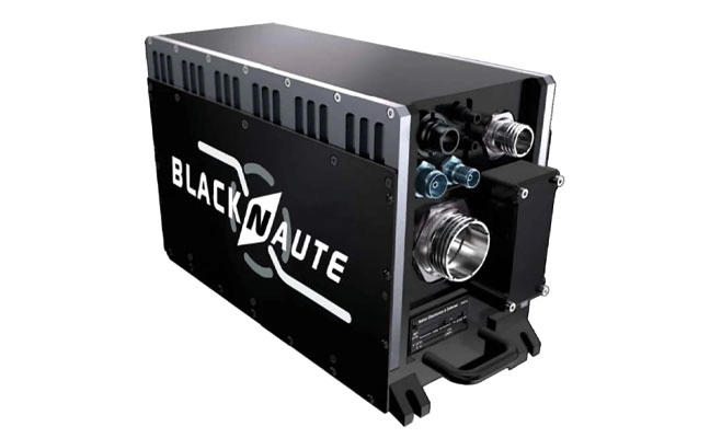
2. PNT system Integrates GNSS receiver, INS, atomic clock
Photo: Safran
The BlackNaute autonomous positioning, navigation and timing (PNT) system integrates Safran’s HRG dual-core inertial navigation technology, the Skylight multi-mode GNSS receiver board, and an atomic clock to offer navigation resilience in challenging electronic warfare environments. BlackNaute’s built-in atomic clock is designed to maintain precise timing, which is essential for secure communications and collaborative combat operations. The system features advanced anti-jamming and anti-spoofing algorithms, which have been validated in more than 16,000 operational cases. These capabilities allow BlackNaute to detect compromised signals and automatically switch to autonomous and trusted navigation and timing sources to ensure continuity of operations. Its modular design allows it to be adapted across a variety of platforms. Airbus Helicopters has selected the NH90 to be equipped with this new Embedded GNSS and Time INS (EGTI). Safran Electronics & Defense, safran.com
3. Interference detection Suite enhanced for greater accuracy, coverage and insight
Photo: US Navy
HawkEye 360’s GNSS-I Detection suite includes powerful enhancements to its GNSS interference detection capabilities. The upgrades — designed with defense, intelligence and national security operations in mind — offer unprecedented accuracy, coverage and insight into global GPS jamming and spoofing threats. The update includes a new wider frequency algorithm that better distinguishes individual emitters, incorporates GPS spoofing detection, and is terrain adjusted for better geolocation accuracy, delivering greater situational awareness and more precise geolocation of interference sources worldwide. The enhanced product suite supports strategic decision-making by providing timely, precise insight into potential signal disruptions, enabling stakeholders to better assess risk, respond confidently, and maintain operational continuity in dynamic environments. HawkEye 360, he360.com
4. VTOL UAS For complex intelligence, surveillance and reconnaissance missions
Photo: ESEN
The GöKHUN unmanned aerial system (UAS) is a tactical vertical take-off and landing (VTOL) drone system developed for versatile missions on land or at sea. GöKHUN combines the compact mobility of a NATO Class I UAV with the performance data of a Class II tactical system. It uses the SP 210 FI GS 2-stroke engine from Sky Power International. With a take-off weight of up to 110 kg and a maximum fuel and payload capacity of 26 kg, the GöKHUN can remain in the air for up to 16 hours with a minimum payload. Even with a demanding sensor load of 12 kg, it can achieve a flight duration of around nine hours, making it suitable for long-endurance reconnaissance and surveillance missions. The GöKHUN’s cruising speed is between 96 and 158 km/h. The maximum range with direct line-of-sight is over 150 km, with the system reaching a service ceiling of approximately 5,500 m. ESEN, esensi.com.tr
In universities across the world, theory lays the foundation, but in the field, realism builds true expertise.
For students studying GNSS engineering, textbooks and simulations alone are no longer enough. Tomorrow’s engineers need to use the same applications and work with the same complex environments that professionals face in the real world. This means using tools that generate actual RF signals, not just software abstractions — tools that recreate urban canyons, interference, jamming, spoofing and satellite dynamics with precision.
Safran has established the Minerva Academic Partnership Program, an initiative that brings its Skydel GNSS Simulation Engine to qualified educational institutions worldwide.
A Modern, Software-Defined Approach to GNSS Simulation
At the heart of this initiative is the Skydel simulation engine, a software-defined GNSS simulator. Built to leverage commercially available off-the-shelf (COTS) hardware, Skydel eliminates the need for proprietary hardware. It delivers the full spectrum of satellite constellations — as well as LEO ones — and frequency bands. By integrating Skydel in their projects, researchers now have the tools to pursue ambitious ideas with confidence, such as:
■ Designing and testing custom signals or constellations not yet in existence
■ Simulating real-world scenarios that can include both environmental and man-made interference
■ Integrating and testing additional sensors and platforms through open-source plug-ins and hardware-in-the-loop setups
■ Conducting rigorous resiliency testing against jamming and spoofing in a controlled, repeatable environment without real-world risk
■ Building their own simulator with existing hardware components around Skydel
Empowering the Next Generation of PNT Innovators
Through the Minerva program, Safran provides full-feature Skydel licenses for faculty and student use, creating an environment where learning and innovation thrive. This initiative not only eliminates the barrier to entry but also fosters collaboration between academia and industry –— fueling a new wave of GNSS advancements.
A Global Initiative
Today, Minerva includes more than 80 member institutions and boasts a growing portfolio of peer-reviewed publications and conference presentations.
“This momentum highlights the real-world impact of the program and its role in driving local research excellence and fostering a vibrant, collaborative international GNSS community,” said Pierre-Marie Leveel, program director of PNT simulation at Safran Electronics & Defense. “Safran Electronics & Defense’s Minerva program is more than just a software — it’s a mission to democratize GNSS simulation and nurture the next generation of PNT researchers. As innovation becomes more critical to national sovereignty, transportation, and space exploration, empowering students and researchers has never been more vital.”
Elevating GNSS Simulation
The evolution of Safran Electronics & Defense’s GNSS simulators — across both software and hardware — has been shaped by the growing demands of users and the broader market.
“The demand for multi-vehicle and multi-antenna scenarios has never been higher, and the same can be said for interference simulation,” said Pierre-Marie Le Veel, program director of PNT Simulation at Safran Electronics & Defense.
To address these challenges, Safran’s GSG-7 and GSG-8 Gen2 simulators are engineered to handle a range of applications, from basic to advanced GNSS jamming and spoofing resiliency testing.
The GSG-7 simulator is designed for location-aware applications and systems that depend on navigation or timing. With high-end performance — featuring a 1,000 Hz simulation iteration rate, high dynamics, real-time synchronization, and all-in-view satellite signal simulation — the GSG-7 is well-suited for development and integration projects that demand high performance and extensive constellation licensing. It supports multi-constellation and multi-frequency GNSS simulations and can be configured to operate with all current and upcoming GNSS signals.
Meanwhile, the GSG-8 Gen2 is the latest iteration of Safran’s GSG-8 model, offering flexible simulation capabilities for any device that relies on GNSS signals. Built on Safran’s Skydel-based simulation platform, the GSG-8 Gen2 helps users model scenarios.
Powered by high-end GPUs, the GSG-8 Gen2 offers reliable and precise GNSS signal testing. It can simulate thousands of signals, run multiple instances at once, and introduce jamming and spoofing to evaluate system resilience. The turnkey system features a redesigned chassis for greater connectivity, including six front-facing, high-quality RF outputs, a combined output covering the full GNSS bandwidth, and the same high-end simulation iteration rate as the GSG-7. This allows users to quickly get up and running with complex simulation requirements.
“The market is also demanding realism,” Le Veel said.
All Safran simulators are powered by the Skydel Simulation Engine, which is updated quarterly. Each release introduces new features, signals, and enhancements, enabling more authentic simulations and offering the flexibility to create virtually any GNSS testing scenario.
Staying Ahead of Market Changes and Signal Threats
The recent increase in signal interference threats has driven the demand for enhanced positioning, navigation and timing (PNT) resilience, leading to the broader use of both conducted and over-the-air (OTA) testing. The anticipated deregulation of controlled reception pattern antenna (CRPA) technology also is expected to open the door for civilian markets to perform testing.
“Throughout the past few years, Safran Electronics & Defense has massively revamped our approach to the Wavefront platform and now offers the GSG-Wavefront for those testing CRPA antennas against jamming and spoofing threats,” Veel said.
The ability to safeguard GNSS networks from jamming and spoofing attacks has never been more vital. Achieving this level of resilience calls for a GNSS simulator that can generate dedicated RF signals for evaluating the effectiveness of CRPA architectures.
Safran’s GSG-Wavefront, featuring a shared local oscillator (LO) design, stands out as a field-proven, off-the-shelf solution for CRPA receiver testing. It has a customizable platform that offers upgradable options powered by Skydel — the company’s GNSS simulation engine.
Le Veel added, “We are working hard to keep up with demand in both the defense and civilian markets.”
In addition, Le Veel noted that Safran’s GSG-Anechoic is attracting attention from users who work with anechoic chambers, thanks to its multiple, independent RF outputs, automatic antenna mapping, and built-in calibration features for delay and power loss.
Safran Electronics & Defense supports a wide array of users in both the civilian and defense sectors, spanning aerospace, critical infrastructure and transportation. In recent years, however, the company has seen its fastest growth in the New Space market. Safran’s simulators are used in a range of cutting-edge applications, including satellite navigation, low-Earth orbit (LEO) constellations, and rocket launch and landing systems.
“We are proud that the flexible tools and features we have included in Skydel are being used in these incredibly robust applications,” La Veel said.
A challenge for most GNSS simulation suppliers is ensuring compatibility and coherence with a wide range of GNSS receivers. La Veel shared that Safran Electronics & Defense is in a unique position, as it also designs and manufactures its own receivers, such as the newly released Skylight.
“Additional challenges can arise when developing new signals or constellations, such as the newest LEO ones, said La Veel. “Our close partnerships with both Xona Space Systems and TrustPoint have allowed us to overcome these challenges.”
A single GSG-8 Gen2 simulator from Safran Electronics & Defense can generate more than 2,000 signals without the need for additional hardware. This capability is essential when modeling legacy signals, multipath effects, jamming and spoofing scenarios, or even LEO-constellations.
Safran simulators support all legacy signals, including GPS, Galileo, BeiDou, GLONASS, NavIC, QZSS and SBAS, across all bands and security features such as M-code, PRS and Galileo OSNMA. The systems also offer compatibility with emerging LEO constellations, including Xona’s PULSAR X1 and X5, as well as TrustPoint. Custom Signals and Custom Constellation features offer users the flexibility to create entirely new signals and satellite constellations, or to modify existing configurations.
“It is de rigueur these days for companies to claim or incorporate AI into their solutions. In addition to using AI for tropospheric modeling based on real-world data, Safran Electronics & Defense has also taken a different approach to using AI in GNSS simulation,” Le Veel said.
He added that the company’s upcoming demonstration at ION GNSS+ 2025 will reveal Skydel AI, a new tool designed to make scenario creation and parameter setting as simple as writing an email. “The amount of people who can easily now test their prototypes, products or systems will dramatically increase as the steep curve to learn GNSS simulation is flattened.”
The European Space Agency (ESA) and Leonardo are embarking on a joint project to explore smart antennas powered by machine learning to block unwanted signals.
Representatives of ESA and Leonardo signed a contract at the Paris Air Show to research and develop machine learning techniques to steer antenna arrays to block out unwanted signals. The project will be developed under the umbrella of ESA’s Navigation Innovation Support Programme (NAVISP).
Smarter antenna designs for resilience
Conventional antennas catch signals from all directions. A controlled reception pattern antenna (CRPA) can focus on signals coming from specific satellites and ignore signals or interference coming from other directions. These types of antennas are used in satellite navigation receivers to block jamming and counterfeit signals. They rely on electronics that control how they adjust their patterns (beamforming).
Under contract with NAVISP, Leonardo — together with ELT Group as subcontractor — will explore the reduction of the distance between the antenna elements to reduce the size and weight of the antenna array, and the use of machine learning to determine the best antenna setup and adjust the settings faster. This approach will lead to smaller, smarter and more effective antennas, especially useful in space-limited environments such as aircraft.
The project covers identification of the smarter algorithm for signal blocking, building and testing a real-time receiver demonstrator based on the selected algorithm, and comparing it to conventional larger antennas. The aim is to reach a Technology Readiness Level (TRL) of 4, delivering a lab-tested technology by the end of the project, in two years.
Calian GNSS has released its next-generation anti-jamming controlled reception pattern antenna (CRPA), the CR8894SXF+.
The CR8894SXF+ is an advanced CRPA, engineered to provide efficient interference protection and real-time situational awareness across critical infrastructure, marine, and defense environments where GNSS continuity is mission critical. The CRPA is specifically-designed to provide a low-power and lightweight solution in a compact size.
It features advanced in-band null forming to protect GPS L1/L2 and Galileo E1/E5b signals, helping ensure resilient positioning, navigation and timing in environments with contested, congested or degraded radio frequency conditions. The antenna incorporates Calian’s eXtended Filtering interference mitigation technology to maintain performance and reliability when RF threats are present.
The CRPA supports in-band null-forming of 20 dB to 40 dB and out-of-band rejection up to 80 dB across 700 MHz to 2,500 MHz. It includes two independent low-noise amplifier channels, allowing continued operation if one signal band is compromised.
The antenna forms nulls in both upper (L1/E1) and lower (L2/E5b) GNSS bands to actively suppress jamming sources. A serial output interface provides real-time feedback, enabling users to monitor RF conditions and system status. Outputs include:
CRPA state: open (no jamming), protected (jamming mitigated), or closed (jammed but protected)
Jammer characterization: azimuth and elevation angles of detected interference sources
Summary of threat signals, offering rapid threat assessment for command and control
The CRPA series aims to set a new benchmark in operational resilience, offering advanced protection and intelligence for mission-critical GNSS applications.
Inertial Labs, a VIAVI Solutions Inc. Company, has introduced the M-AJ-QUATRO anti-jamming antenna system, designed to ensure assured positioning, navigation and timing (A-PNT) in GNSS-challenged environments. The system incorporates advanced Controlled Reception Pattern Antenna (CRPA) technology and digital processing capabilities, making it suitable for applications ranging from military operations to commercial aviation.
PNT services are increasingly critical for various sectors, including transportation, telecommunications, artificial intelligence, hyperscale data centers, energy, finance and defense. As GNSS jamming and spoofing threats grow, government agencies and industry leaders are working to address these challenges. For instance, the Federal Aviation Administration and Naval Air Warfare Center Aircraft Division are expediting approval processes for CRPA technology to enhance aviation safety and counter GPS interference.
The M-AJ-QUATRO supports the L1, L2, and L5 GNSS bands and offers robust interference suppression capabilities. Its adaptive digital nulling feature automatically mitigates jamming signals with over 34dB+ suppression in the export-free version and over 45dB+ suppression in the export-controlled version. Additionally, the system can identify and locate sources of interference through its jammer direction-finding capability, improving situational awareness.
It is compatible with multiple GNSS constellations to provide comprehensive global coverage. It employs dual FPGA-based encryption and anti-spoofing technologies for secure signal processing and data integrity. Built to meet stringent military standards like MIL-STD-810G and MIL-STD-461F, the M-AJ-QUATRO is engineered to withstand extreme conditions, making it an ideal solution for defense and aerospace applications.
The Federal Aviation Administration (FAA) has partnered with the Naval Air Warfare Center Aircraft Division (NAWCAD) to initiate steps toward approving Controlled Reception Pattern Antennas (CPRAs) for use in aircraft. This collaboration addresses GPS/GNSS jamming and spoofing threats, with the current focus on a Request for Information (RFI) to study anti-jamming and anti-spoofing technologies. The RFI, published on SAM.gov, aims to identify and evaluate vendors’ antenna technologies for potential integration into civilian aircraft.
CPRAs could significantly mitigate terrestrial-based GPS/GNSS jamming and spoofing, enhancing aviation safety by preserving situational awareness and reducing pilot workload during disruptions. The technology’s effectiveness in neutralizing ground-based threats positions it as a critical tool for maintaining reliable navigation systems.
RFI details and next steps
NAWCAD is leading the RFI process, which includes hosting industry days and establishing Cooperative Research and Development Agreements for testing hardware and evaluating performance. Responses to the RFI are due by May 26, 2025, at 5:00 PM EST, with questions accepted until April 25, 2025. Data from the RFI and subsequent testing will inform updated Minimum Operational Performance Standards for GPS/GNSS antennas and cockpit displays.
Dana Goward, president of the Resilient Navigation and Timing Foundation, noted that this is a great first step, but cautioned that widespread adoption of CPRAs in commercial aircraft will take a long time due to the lengthy FAA approval and certification processes, along with the significant financial investment and effort required to install CRPAs in airplanes.
Although CPRAs address terrestrial threats, space jamming continues to be a critical concern. Adversaries often outpace countermeasures, necessitating continuous innovation to keep up with advancing threats.
FAA safety alert highlights risks
The FAA issued Safety Alert for Operations (SAFO) 24002 on Jan. 1, 2024, to alert operators and manufacturers about the risks of GPS/GNSS disruptions. The alert emphasized the potential for increased pilot workload and safety risks due to situational awareness loss during jamming or spoofing incidents.
On Jan. 17, 2025, the State Department proposed removing CPRAs from the U.S. Munitions List (USML), shifting their regulation to the Commerce Department’s Export Administration Regulations (EAR). This change, effective Sept. 15, 2025, aligns CRPA export controls with other dual-use technologies, streamlining their adoption. A 60-day public comment period is open via regulations.gov.
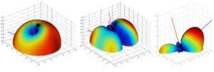
Illustrative beam patterns of a CRPA antenna in the presence of jamming (Figure: Michael Jones)
Controlled Reception Pattern Antennas (CRPAs, pronounced “serpers”) are still the single most effective counter to the threat to GNSS from jamming and spoofing — a growing problem in and near conflict areas, such as Ukraine and the Middle East. CRPAs, which make use of the fact that the desired satellite signals and the unwanted jamming signals generally arrive from different directions, reduce the effective range of jammers by up to five orders of magnitude. They are attractive because they replace existing antennas on GNSS receivers without requiring any other changes — though they are generally larger than typical GPS antennas because they contain several antenna elements and some associated electronics.
Beginning on Sept. 15, 2025, CRPAs will no longer be covered by the International Traffic in Arms Regulations (ITAR), which prohibit the sale outside of the United States of defense articles, services and technical data and impose very large penalties for violators. ITAR is managed by the Directorate of Defense Trade Controls (DDTC) in the Bureau of Political-Military Affairs at the U.S. Department of State, which announced the rule change in mid-January. It removes items that “no longer warrant inclusion” from the U.S. Munitions List (USML), which defines the “defense articles” that fall under ITAR jurisdiction. CRPAs for PNT will instead be classified as dual-use commercial items and fall under the Export Administration Regulations list managed by the Department of Commerce. The Directorate removed CRPAs for PNT from the USML because they “no longer provide a critical military advantage, with increasing commercial utilization applicable to civil GPS resiliency” and because the department “intends to facilitate civil global navigation system resiliency.”
This is a seismic shift that many in the GNSS/PNT community — including the National Space-Based Positioning, Navigation and Timing Advisory Board (PNTAB) — have been advocating for years. While U.S. manufacturers have been prohibited from exporting CRPAs, TUALCOM, a Turkish company based in Ankara, has been selling 4- and 8-element CRPAs for GNSS applications, as have some Canadian companies.
Airlines and manufacturers of autonomous vehicles will be among the early beneficiaries of this policy change, as will many safety-of-life applications. Presumably, the vast expansion in the market for CRPAs also will quickly lead to a sharp drop in their cost.
In a November 2022 presentation to the PNTAB, Brad Parkinson listed the use of CRPAs among the major techniques that can make GPS receivers “virtually immune” to jamming and spoofing, recalling that they were first tested in 1978. However, he pointed out, they had been neglected because they were perceived as too expensive and large for many applications, because of delays in implementing the L5 signal, and because ITAR prohibited beam-steering antennas with more than three elements. He argued that restrictions on GNSS CRPAs were no longer effective at preventing potential enemies of the United States from using them.
Barring a reversal from the new administration, U.S. CRPA manufacturers can now help protect GNSS worldwide from jamming and spoofing.
The Directorate of Defense Trade Controls (DDTC) has changed the regulatory status of Controlled Reception Pattern Antennas (CRPAs) for position, navigation and timing (PNT). Starting September 2025, CRPAs will no longer be subject to the International Traffic in Arms Regulations (ITAR). Instead, they will be reclassified under the less restrictive Export Administration Regulations (EAR) list, which is under the jurisdiction of the Department of Commerce.
The rule, in part, removes items from the U.S. Munitions List (USML) “that no longer warrant inclusion.” According to the rule, “certain anti-jam antennas no longer provide a critical military advantage, with increasing commercial utilization applicable to civil GPS resiliency.” By removing CRPAs for PNT, “the Department intends to facilitate civil global navigation system resiliency.”
The recent regulatory change is expected to significantly impact several industries, including airlines, autonomous vehicles, UAVs and critical infrastructure applications, which can benefit from the increased availability of CRPAs. Additionally, this change may open the U.S. market for CRPA manufacturing, potentially resulting in swift technological advancements and lower costs.
The importance of CRPAs lies in their ability to protect GNSS receivers from interference and jamming. GNSS signals are inherently weak and susceptible to both deliberate and unintentional interference. CRPAs work by adjusting their reception pattern to create nulls in the direction of interfering signals while maintaining reception from desired satellite signals. This adaptive beam steering capability allows CRPAs to effectively eliminate signals from particular directions while preserving signals from others, making them a powerful tool in ensuring the reliability of GNSS-dependent systems.
Syntony GNSS has released CERBER, a GNSS receiver embedded in a CRPA solution.
A classic CRPA system consists of embedded GNSS antennas and antijamming treatments. However, CERBER relies on the tight integration of a CRPA treatment (with a 4-array antenna) and the embedded GNSS receiver.
The estimation of GNSS direction of arrival (DoA) is enabled and allows the receiver to check whether those DoA estimations are compatible with GNSS constellations or originate from very few directions. Therefore, users will be able to detect and locate spoofing devices or receivers instantly.
The receivers are also able to constantly recalibrate the chains of reception based on the DoA and GNSS signals.
CERBER’s embedded approach also enables a 6dB power gain in satellites’ directions, the continuity of GNSS signals’ phase when the space-time adaptive processing (STAP) filter is updated, the absence of additional noise that a GNSS receiver would imply with the re-generation and re-digitalization of RF signals and an improved rejection performance when compared to a classic CRPA + independent GNSS receiver solution.
This technology is designed for the protection and the surveillance of civil critical infrastructures, including Galileo’s and EGNOS’ ground segments, airports or any infrastructure requiring precise and resilient GNSS timing.
ByBradford W. Parkinson Aeronautics and Astronautics Professor Emeritus (recalled) Stanford University
Brad Parkinson
We, of the PNT universe, have been hearing a rather continual message of doom from the media regarding the fragility of the GPS (or GNSS) signals. In a way, they are right. The received GPS signal is 1/10th of 1 millionth of 1 billionth of a Watt. It can be susceptible to jamming and spoofing.
In response, the U.S. government has sponsored major studies and some competitive tests of techniques to augment or possibly replace GPS. I applaud such queries, but also would strongly advocate more balance in efforts to increase robustness of positioning, navigation and timing (PNT).
Specifically, I argue for increased emphasis on well-known techniques that can greatly toughen GNSS receivers to both jamming and spoofing. Some of these techniques are deliberately denied to civil users by government policy.
Background
The PNT Advisory Board (PNTAB) is a panel of national experts who report to the PNT ExCom. The ExCom is comprised of the deputy heads of the nine U.S. government departments with the largest stakes in PNT. The PNTAB has a starkly simple and well-stated goal:
To meet its overarching goal, the PNTAB has developed a three-legged strategic framework, known as “PTA”: “We must protect, toughen and augment GPS to ensure that it continues to provide economic and societal benefits to the nation.”
Most current U.S. government efforts have been focused on the third of the PNTAB strategic legs: augmenting the GPS system. These system augmentations include: modernized Loran (eLoran), fiber-optic distribution of time, and ranging to low-Earth-orbit (LEO) satellites (particularly the swarms of communications satellites). In general, these system augmentations offer no hope of being equivalent to GPS in terms of availability and accuracy.
However, augmentations have the advantage of either being less vulnerable to interference, or highly proliferated in case of satellite outages. As supplements, or in an emergency, they can perform a very valuable role, but with nowhere near the equivalent performance of normally operating GNSS, which can routinely provide worldwide, 24/7 precisions better than decimeters in the dynamic real-time kinematic (RTK) mode. In the United States, GPS also offers continuous, real-time integrity assessments courtesy of the FAA1. Europe has a similar, compatible integrity system called EGNOS, and there are other regional system augmentations.
In summary, the current PNTAB assessment regarding these substitutes is:
“No current or foreseeable alternative to GNSS (primarily GPS) can deliver the equivalent accuracy (static down to millimeters) and worldwide, 24/7 availability.”
Toughening User Equipment
Toughening, the second leg of our assurance strategy, includes all aspects of GPS enterprise vulnerability — satellites, ground control and user equipment. For this article, I am focused on toughening the user equipment. I would argue that we have largely under-emphasized, or been prohibited by national policy from using, well-known and widely available user equipment toughening technology.
The main vulnerabilities of GPS receivers are jamming and spoofing of the received signals. Familiar anti-jam (A/J) methods can substantially overcome the inherent weakness of GPS signals to defeat deliberate jamming and spoofing. As I outline here, such measures can reduce a jammer’s effective radius by a factor of more than 100 and reduce the effective jammer area by a factor of 10,000 compared to the unprotected receiver.2
Thus, these methods are also deterrents, because they can render ineffective such hostile (or possibly inadvertent) acts. Further, the technology that provides this significant toughening is available now or will be within a few years, rather than the many years required by some alternative, system-level augmentations.
Toughening techniques (A/J improvements) are traditionally calibrated as the improvement in the amount of jamming that can be tolerated, measured by the jamming-to-signal power ratio (J/S) expressed as decibels (dB). However, for this discussion, I will also use a different, more intuitive, measure. This metric is the Denial Radius Reduction Ratio (DRRR):
DRRR = (radius of jammer denial after J/S measure applied)/(jammer radius without improvements)
For example, a 15-dB improvement in J/S would lead to a DRRR of 0.178.3 In other words, the 15-dB improvement has reduced the denial radius to about 18% of the line-of-sight radius that would be denied to an untoughened receiver. Note that the simultaneous use of techniques is generally multiplicative. For example, simultaneously applying technique #1 with a DRRR1 of 0.5 and technique #2 with a DRRR2 of 0.3, would result in a DRRR1&2 of 0.3 *0.5, or an overall DRRR of 0.15. This is the advantage of using this metric to describe the A/J improvements. 4
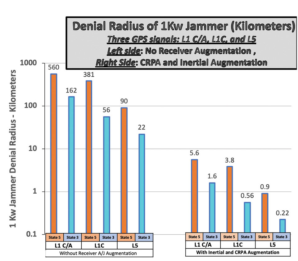
Baseline Case
For our basis for comparison, we will consider the L1 C/A signal in full accuracy (State 5) tracking mode and a 1-kW noise jammer.5,6 For this situation, the line-of-sight jammer could deny GPS to a radius of about 560 kilometers. A discussion of the lower accuracy State 3 tracking is included below.
It is useful to consider toughening techniques in four major categories.
Toughening Category 1: Signal Processing. With L1 C/A, GPS receivers can improve jamming resistance, albeit with loss of ranging (tracking) accuracy, by using code tracking mode – State 3. This reduces a line-of-sight jammer’s denial radius (DRRR) to about 0.29 (a 10.7 dB improvement).
Toughening Category 2: Inertial Components and Very Stable User Clocks. This includes miniature micro-electromechanical (MEMS) components up to high-grade inertial measurement units (IMUs) and quartz to chip-scale atomic clocks (CSACs). These techniques enable narrower tracking filters and longer averaging, as well as allowing navigation through regions when GPS is denied. The range of DRRRs is 0.40 down to 0.10. We will use a nominal value of 0.18 (a 15-dB improvement).
Toughening Category 3: CRPAs. Controlled reception pattern antennas (CRPAS) are digital, multi-element, phase-steered antennas. They represent well-understood and available technology; they have been used in large surface-search radar systems for many decades.7 They can be used in null-steering or beam-steering modes.8 The number of antenna elements could range up to dozens. Potentially, they could produce DRRRs down to .01 — that is, a 99% reduction of jammer radius to 1% of the unprotected GPS receiver value.
Unfortunately, the U.S. government does not allow more than three-element CRPAs to be manufactured or sold for civil use. 9 This is due to some very old International Traffic in Arms Regulations (ITAR). For our nominal example, we will assume the restriction has been relaxed and use a CRPA of about 20 elements, which should produce a DRRR of 0.06 (a 25-dB improvement).
Toughening Category 4: Signal Alternatives. This category includes alternative modulations at 1575 MHz (L1C, Galileo or other GNSS) and alternative frequencies (L5, L2, Galileo). Note that the modern signals generally offer significantly improved signal-processing toughening as well as increased power.
Using L1C in State 3 compared to L1 C/A in State 5 would yield a DRRR of 0.10. (a 20.3-dB improvement). The L1C international signal should be operational on GPS by mid-decade. The L5 signal, at 1176 MHz, is clearly the most capable of the civil GPS signals in terms of jam resistance. L5 also should be declared operational by mid-decade. As the use of LEO communication satellites matures, their use may also fit this category.
Summary of Receiver Toughening Options. Quantification of the selected, nominal receiver augmentations are summarized in FIGURE 1 for both full accuracy (State 5, centimeter-level accuracy in RTK) and for less accurate code tracking (State 3, meter-level accuracy). These results are shown with a logarithmic scale to accommodate the wide range of denial radii.
Figure 1. Effect of receiver augmentations on accuracy for both State 5 and State 3. (Image: Brad Parkinson)
The example shows that a 1-kW hostile jammer’s denial radius10 can be reduced by a factor of about 100, using the conservative example augmentations of inertial and CRPAs. Because area is proportional to radius squared, the effective denial area of an augmented receiver would be 1/10,000th of the unaugmented receiver, using the example values.
Reverting to code-only (State 3) tracking, it enables operating through higher levels of jamming, albeit with less ranging precision. All these receiver augmentations and tracking techniques would also offer a significant defense against any attempt to spoof (deceive) the position measurement. Again, none of these techniques are new; we demonstrated the capabilities at the original GPS Joint Program Office in 1978, more than 40 years ago. Today, many competent manufacturers are offering toughened GPS receivers with combinations and variations of these techniques.
GPS jamming tests at White Sands have caused aircraft interference, which could be largely avoided with toughened receivers. Here, M-code is tested on Joint Light Tactical Vehicle platforms in 2020. (Photo: Joe Bullinger/U.S. Navy)
Meeting Increasing Threats
Threats of both jamming and spoofing seem to have accelerated. Devices to perform these illegal acts are freely advertised on the internet. In fact, we read of incidents both in the United States and abroad.11 Near White Sands Missile Range in New Mexico, there have been GPS air traffic control outages due to authorized military operational jamming exercises. Such interruptions could be largely avoided if more robust (toughened) GPS receivers, with the enhanced jam resistance techniques outlined here, were in use.
News reports also highlight the spoofing issue. Hardening against this threat is also a task for toughening. A serious spoofing sequence usually starts with a strong jamming signal to cause the user’s receiver to break lock, followed by a strong false GNSS signal that causes false lock by the receiver. Using the false signal leads to a false position, of course. The first line of defense is to avoid the break-lock threat. Failing this, numerous self-check and authentication schemes can be used to avoid false positions.
A conclusion is that avoiding the break-lock jamming is a first line of defense against a spoofing attack. Of course, the toughening techniques to avoid this are the main subject of this paper. One well-known expert has stated that, for a well-designed receiver, a spoofing attack might deny the measurement of position, but should never cause false PNT. I will leave further discussion of spoofing to other authors.
Returning to disruptions of service in general, some have suggested many interference occurrences have gone unreported, because the typical user would not know where to make such a report. To remind the reader, the official reporting center is online at www.navcen.uscg.gov/?pageName=gpsUserInput.
In addition, the U.S. Federal Communications Commission (FCC) has repurposed a portion of the spectrum adjacent to the main GNSS L1 frequency (1575 MHz). The agency is converting the license holder’s original authorization to transmit a weak space-transmitted signal into a much stronger terrestrial system, potentially with thousands of transmitters. Extensive testing of civil GPS receivers by the U.S. Department of Transportation demonstrated that the planned repurposing will interfere with many existing receivers. Some observers call this disruption “legal jamming.”
Such a new spectrum use could have grave impacts on those existing receivers, notably aviation (especially helicopters and UAVs) and first providers. On the other hand, installing toughened replacement receivers would make the users virtually immune to this threat.
So, this begs the question: If the receiver toughening techniques are so effective, why are they not more prevalent?
Barriers to Adoption
Let’s examine the potential resistance to more extensive use of receiver augmentations.
Knowledge. This involves underestimating the threat to PNT and not understanding that toughening techniques are available. As mentioned above, threats to the fragile GNSS signals are growing.
There seems to be little interest in the U.S. government to monitor and suppress interference in the United States. Internationally, the reported incidents continue to increase.12 It is also reported that certain European aircraft manufacturers have installed advanced, deeply integrated inertial systems with civil GNSS receivers to defeat or “flywheel” through radio-frequency threats (particularly in the Middle East).
As this threat trend continues, GPS manufacturers and users must realize that many of these solutions will take time to authorize, implement and install. It appears that the media are not aware that not only are the toughening techniques outlined here feasible, but many manufacturers have product offerings that address these threats. Having off-the-shelf solutions will give the PNT user the opportunity to retrofit and defeat such threats.
Cost. The cost for a receiver to revert from State 5 to State 3 is zero, and all receivers that use Code 5 (for example, RTK) would naturally have this built in. Regarding use of other frequencies (such as L5) and modulations (L1C) rather than the original L1 C/A, there is some small cost associated, including the additional antenna for L5. Note that all modern cellphone chips, such as Qualcomm’s, have this capability — including integrated carrier-phase measurements — in a chip that is estimated to cost about $5. A potential barrier is that the L5 and L1C signals are not yet declared operational, but these newer GPS signals should be operational within about five years.
The costs of many inertial components (accelerometers and gyros) have plummeted in the last few decades with the proliferation of MEMS devices, particularly into cellphones and automobiles. Their power consumption has also decreased while their performance has steadily improved. Full IMUs are much more expensive, but are already installed on many commercial aircraft. Robust toughening with inertial sensors can be achieved, but requires deep integration and careful engineering.
Depending on their complexity, CRPA antennas can be a costly receiver augmentation. Very high-speed (330 MHz is available), 16-bit, A-to-D converters are at the heart of most of these phased-array devices. Some are priced at about $150 each. Applications with a high premium for PNT availability in the face of interference — such as commercial aircraft and cargo ships — should find them affordable. Aircraft manufacturers have resisted retrofitting existing aircraft with larger diameter CRPA antennas because of costs. For some of these applications, integration costs can be more than the costs of the receiver itself, particularly if not included in the original manufacture.
As the yearly sales of fully toughened receivers increase, the economies of scale should significantly reduce unit costs. Each application will make its own determination of affordability, based on risk.
Government restrictions. Civil use of CRPAs with four or more elements is restricted by ITAR. These are well-meaning restrictions on technologies that could be used against the United States by hostile military forces. Unfortunately, the phased-array antenna techniques are not only well understood and tested, but relatively inexpensive components are widely available on the open world market. In particular, the restriction on the number of CRPA elements for civil use should be completely removed. All potential enemies are well aware of the beam-steering method and have ready access to the parts to build them. Thus, the restriction is only harming civil users without affording any apparent improvement in general military posture.
Certified aviation receivers need approval for deep integration of inertial systems and multi-element CRPAs. (Photo: JasonDoiy/iStock/Getty Images Plus/Getty Images)
Gaining permission: FAA flight certifications. To be used in commercial aircraft operations, navigation equipment must be certified by the U.S. Federal Aviation Administration (FAA). Current, certified GPS aviation receivers have rudimentary toughening techniques, but gaining approval for deep integration of inertial systems and multi-element CRPAs must be completed. It is gratifying to hear that work is underway to do this.
Any civil solution for the United States must expand integrity monitoring beyond GPS to include all GNSS, and must be operationally included in the FAA’s integrity monitoring with WAAS.
Recommendation
In describing resistance to interference, I have introduced the idea of DRRR – Denial Radius Reduction Ratio. Also, I have used a 1-kW white-noise jammer as a standard threat for calculating the denial radius of various GPS receiver configurations. My recommendation is that equipment manufacturers specify their receiver offerings by stating their equipment’s denial radius against a “standardized” 1-kW EIRP white-noise jammer.
Summary
Media reports of interference to GPS may be accurate, but they generally do not recognize that available toughening techniques can largely defeat those interference threats. While exploring systems-level replacements or augmentations (such as LEO ranging or Loran) is worthwhile, GPS (or GNSS) still offers the greatest capability in combined terms of accuracy, integrity and coverage.
The goal of all PNT providers — GPS operators, certifiers and manufacturers — should be assured PNT, with the expected accuracy and availability. The described toughening techniques to do that have been known for decades, but have not been generally adopted by many critical civil users. Many manufacturers do offer civil products under existing government constraints.
The purpose of this article was to describe and advocate the solutions available to increase the robustness and toughening of civil GPS receivers. For example, readily available toughening augmentations for civil receivers can reduce the denial radius of interference by 99% or more. This implies that any denied area would be squeezed down to 1/10,000th of that experienced by an unaugmented receiver.
The payoff is high, and should be affordable to many high-end, safety-of-life users. Therefore, a renewed focus on toughening of GPS receivers is overdue. We discussed barriers to rapid adoption but, more than the specifics, it is crucial to fully and urgently embrace the goal of toughening receivers, particularly removing the ITAR restriction on antennas.
Opinions expressed in this article are those of the writer and should not be construed as the official position of the PNTAB or any U.S. government organization.
Notes
1. While not a part of the U.S. Department of Defense’s GPS operation, the FAA’s integrity signal (WAAS) is a GPS-type signal directly available and being used by almost all modern GPS receivers, including cellphones.
2. This is the ration of Denial Radius between, for example, unaugmented L1 C/A in State 5 and augmented L1C in State 3. Please see later footnote and graph.
3. Calculated as 10 (–15/20)
4. Of course, the more traditional dB measure of jammer resistance can (in most cases) be simply summed to estimate the total effectiveness. The use of DRRR gives a more intuitive calibration, particularly for non-technical persons who may not be at all familiar with dBs.
5. State 5 is the tracking mode that provides full accuracy; it requires tracking both the PRN code and the reconstructed carrier. It is required for RTK positioning, which is usually used for automatic control of machines or vehicles. It is most vulnerable to interference. Less vulnerable is State 3 tracking, which only provides code tracking, with precisions of perhaps a few meters.
6. Deliberate jamming using “matched spectrum” GPS-like modulations have also been employed in the Middle East. The toughening techniques described are also generally applicable, with appropriate rescaling. The matched spectrum is fundamentally used to improve the jammer spectrum efficiency.
7. See Michael Jones, “Anti-jam systems: Which one works for you?”, posted on gpsworld.com on June 14, 2017, for a survey of manufacturer offerings at that time. Named companies generally continue to offer improved, jam-resistant products.
8. Phased-array antennas, by their nature, distort phase and would probably have to be calibrated for precise operations such as RTK. Fortunately, we understand that this problem has been reportedly addressed and largely solved by the U.S. Navy’s JPALs program.
10. The denial radius results shown can be easily scaled for weaker or more powerful jammers. The scaling goes as simply the square root of the power ratio of a different size jammer to the 1-kW example. A 10-watt jammer is 1/100th the power of the example. The denial radius would then be one tenth of the example, which is the square root of 1/100.
11. “Ships have reported an increasing number of cases of significant GPS interference and jamming in recent months. The geographic areas with more than one reported incident include the eastern and central Mediterranean Sea, the Persian Gulf, and multiple Chinese ports.” (Source: www.gard.no/web/updates/content/30454065/gps-interference-and-jamming-on-the-increase).
“North Korea is using radio waves to jam GPS navigation systems near the border regions, South Korean officials said. The broadcasts have reportedly affected 110 planes and ships and can cause mobile phones to malfunction.” (Source: www.bbc.com/news/world-asia-35940542).
12. “Reports of GPS outages submitted by pilots from the cockpits of commercial flights show that disruptions to the navigation system, which was created and is maintained by the U.S. government, are now standard occurrence on the flight routes between North America and Europe and the Middle East, according to data from the European Organization for the Safety of Air Navigation, known as Eurocontrol.” Fortune Magazine, Nov. 1, 2020.