Nearly 50 years ago, in December 1973, the Defense Systems Acquisition Review Council approved the Navstar Global Positioning System for entry into Phase I of development. Since then, through its development, deployment and continuing modernization, GPS has grown into a complex program. It is operated by the Department of Defense based on legislation from Congress, executive orders from the White House, and policies established jointly with the Department of Transportation. It supports U.S. military missions as well as myriad scientific, commercial and consumer applications around the planet. Of course, the last category, with its billions of users, now dwarfs all the other ones combined.
The GPS program, with an annual budget of nearly $2 billion and no user fees, is a gift from U.S. taxpayers to the world. It has staff in Washington, D.C.; at the Pentagon in Arlington, Virginia; at Schriever Space Force Base, Colorado; at the Space Systems Command at Los Angeles Air Force Base, California; at Cape Canaveral, Florida; at the U.S. Coast Guard Navigation Center in Alexandria, Virginia; and at GPS ground antennas in additional locations around the world. From the White House to Congress to aerospace companies, from military officers to civilian civil servants, from policy makers to engineers, from the East Coast to the West Coast to remote islands in the Pacific, Indian and Atlantic Oceans, GPS is a vast enterprise — most of which is little known even to people in the industry and virtually unknown to the public.
The Global Positioning System is a vast and mostly unknown enterprise. This section — the first in an occasional series of authoritative reference pieces in this magazine — aims to clarify who does what to maintain GPS as a fantastic global utility. The relevant missions of agencies or units are in italics.
After I researched and drafted the piece, I asked the experts listed below to review it and provide corrections and additions. While grateful for their substantial feedback, I take sole responsibility for any remaining errors or omissions.
Thank you to the following experts:
Harold W. Martin III, Director, Space-Based Positioning, Navigation & Timing, National Coordination Office
Michael J. Dunn, Capability Area Integrator for PNT, Space Systems Command, United States Space Force
Lt. Col. Robert O. Wray, Commander, 2nd Space Operations Squadron, United States Space Force
Scott R. Calhoun, Commanding Officer, Navigation Center, United States Coast Guard
Paul Benshoof, Technical Director, 746th Test Squadron (AFMC), Central Inertial and GPS Test Facility
Bernard Gruber, Senior Director, Northrop Grumman
Please return to this page periodically to read corrections and updates to this special section. If you spot any significant inaccuracies or omissions, please bring them to my attention by writing to me at [email protected].
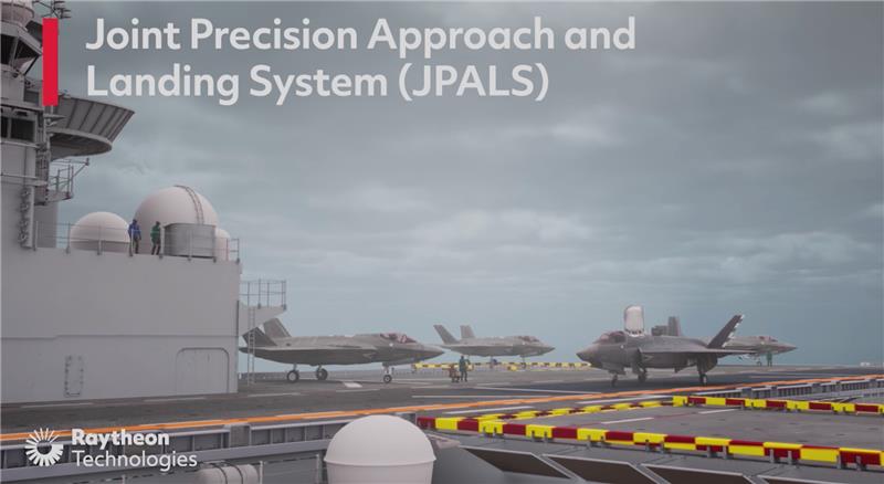
Raytheon Intelligence and Space has been awarded a contract from the United States Navy’s Naval Air Traffic Management Systems Program Office to deliver the Joint Precision Approach and Landing Systems (JPALS) to the Japan Maritime Self-Defense Force (JMSDF). The GPS navigation and precision landing system will be deployed on the JMSDF JS Izumo carrier.
The JPALS system guides aircraft onto carriers and assault ships in all weather and surface conditions and is integrated on all F-35 aircraft. JPALS is also being deployed on all U.S. Navy aircraft and assault ships.
In addition, JPALS will be deployed on two international platforms, including the United Kingdom Royal Navy’s HMS Queen Elizabeth, and an Italian aircraft carrier, the ITS Cavour, to support its F-35 squadron.
The primary work locations for JPALS are in Largo, Florida and Fullerton, California.
A roundup of recent products in the GNSS and inertial positioning industry from the January 2023 issue of GPS World magazine.
SURVEYING & MAPPING
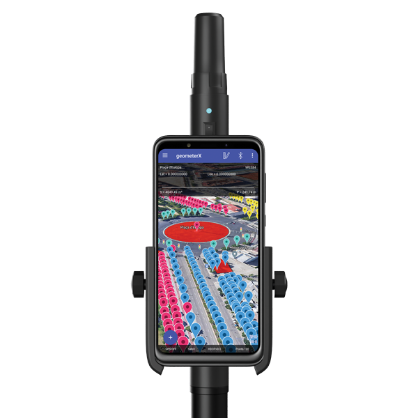
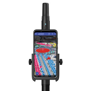
Image: Geometer International
Dual-Frequency Receiver
Receives all GNSS constellations plus SBAS
The Walker RTK is a dual-frequency GNSS receiver (L1, L2) for high-precision coordinate surveying in real-time kinematic (RTK) mode. It comes with a helical antenna, a bracket for attaching a smartphone, and the Geometer SCOUT mobile app. A classic geodesic antenna can be connected through the SMA connector. The Walker RTK has a rugged aluminum alloy casing with a shock-resistant coating, yet weighs only 250 grams. GNSS signals processed by the Walker RTK GNSS receiver include GPS (L1C/A, L2C), GLONASS (L1OF, L2OF), Galileo (E1B/C, E5b), BeiDou (B1I, B2I), QZSS (L1C/A, L1S, L2C) and SBAS (L1C/A). A built-in rechargeable battery provides 24 hours of continuous operation without recharging.
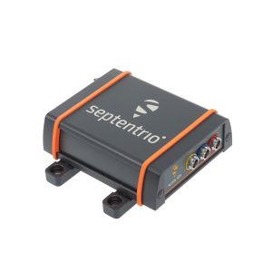
The AsteRx SB3 ProBase creates high-quality measurements for real-time kinematic (RTK) and differential corrections. The IP68-housed GNSS base station receiver features the latest quad-constellation GNSS technology and complements the SB3 receiver family: the AsteRx SB3 Pro rover receiver, the AsteRx SB3 Pro+ rover and base receiver, and the AsteRx SB3 CLAS for the Japanese market. The SB3 ProBase is easy to configure, the company says. It comes with Septentrio’s GNSS+ technologies, including anti-jam and anti-spoofing technology (AIM+) for robustness and reliability. AsteRx SB3 products are pin-to-pin compatible with the AsteRx SB ProDirect receiver and the recently released AsteRx SBi3 GNSS/INS system.
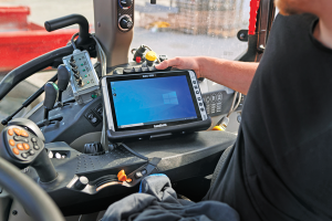
The Algiz 10XR is a rugged 10-inch Windows tablet that combines durability with a GNSS receiver and 5G communications. It was developed for challenging environments in logistics, mining, public transport, public safety, waste management or geographic information systems (GIS). The 10xR is customizable and has a dedicated multiband GNSS u-blox NEO-M8U receiver for accurate positioning as well as untethered dead-reckoning technology. The high-resolution, sunlight-readable 10-inch touchscreen has super-hardened glass and rain-and-glove mode. The tablet also has 4G/LTE high-speed data, Wi-Fi and Bluetooth.
The VZ-600i terrestrial laser scanner has a 3D position accuracy of 3 mm and less than 30 seconds of scan time for high-resolution scans with 6 mm point spacing at 10 m. This enables more than 60 scan positions per hour with real-time registration. Weighing less than 6 kg (13 pounds), the VZ-600i has a 2.2-MHZ pulse repetition rate, three internal cameras and an integrated GNSS receiver. It also includes key features to speed up workflows in indoor and outdoor applications such as architecture, engineering, construction, building information modeling, as-built surveying, forensic and crash scene investigation, archaeology and cultural heritage documentation and forestry.
The LP360 Drone software system provides a geospatial-data workflow for UAV lidar and photogrammetry data processing. It provides powerful point cloud visualizations with multiple, synchronized windows. It can transform lidar and imagery data into survey-grade deliverables including visualization, quality checks, classification, analysis and 3D editing. For users of larger datasets, LP360 Geospatial can process captured lidar data or images from any aircraft or mobile sensor and analyze and extract values.
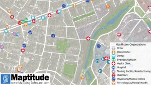
Free library offers data on healthcare, business, traffic
The extensive Maptitude library of free mapping databases has been updated for 2022 and is available for download, supporting insightful business development analysis. The data is available free to users of the latest version of the Maptitude mapping software. The data are also available as shapefile, KML, KMZ or GeoJSON for a fee. Maptitude includes business-critical data such as demographics, boundaries, streets, and the most ZIP Code/postal boundaries. Also available is a catalog of free premium datasets that can be used in other GIS applications, on the web, or in corporate databases.
Indoor and outdoor tracking of low-power, small IoT devices
Traxmate is integrating Nestwave GNSS location technology into its asset-tracking platform for seamless indoor and outdoor positioning, tracking and routing of small, low-power and battery-powered devices for the internet of things (IoT). Nestwave’s NestCore IP and NestCloud cloud services enable power-efficient geolocation solutions, while Traxmate (pictured) is a comprehensive data-processing hub that simplifies setup of tracking environments and provides real-time visualization of device location. The resulting geolocation solution is suitable for applications ranging from carrier tracking to tracking individual parcels and packets. Traxmate is simple to use and set up, requires no coding, and provides an out-of-the-box feature set that includes dashboards, alerts and processing rules for taking actions on incoming data. Nestwave’s trackers include ThinTrack, an ultra-low-profile, compact GPS tracking solution that integrates an LTE-M/NB-IoT modem, antenna, battery and SIM into a device that measures 82 mm x 35 mm x3 mm and weighs 15 g.
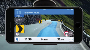
Provides guidance even without an internet connection
The Sygic GPS Navigation app uses a smartphone’s camera and augmented reality to display navigation instructions over the view ahead on the windshield. The head-up display is especially useful at night, enabling recognition of critical speed limit, road work or traffic restriction signs. Cockpit is a powerful tool that shows the real-time performance of the car, measuring the G force and actual speed to help users drive economically. The Dashcam feature records the road ahead and automatically saves the video in case of an accident. An Electric Vehicle Mode locates nearby charging stations.
Enhanced data-based rule implementation for fleets
An enhanced SureCam video telematics integration provides fleet managers with access to new capabilities to keep drivers safe and maximize fleet efficiency. The solution features a method for capturing video footage from SureCam cameras using Geotab’s powerful telematics device and rule-based system. The result is a seamless display of video within the MyGeotab platform. The enhanced SureCam fleet video solution leverages Geotab’s numerous data-based rules, such as improper seat belt usage and speeding. It uses G-force triggered alerts that detect unsafe driving behaviors and automatically captures video footage that can be reviewed later on the MyGeotab platform and alert managers to incidents when necessary. Camera configuration and customized triggers are managed directly within MyGeotab.
Driver 2.0 is a Level 4 production-ready autonomous driving solution that can operate in complex and challenging traffic environments. Demonstrations with Driver 2.0 showed an autonomous vehicle could maneuver around double-parked cars, e-scooters and pedestrians, negotiate oncoming vehicles to calculate the right timing and trajectory to pass busy intersections, and make multiple lane changes and unprotected left turns. In the case of long tail scenarios, the system will alert the remote monitoring center to intervene or take other safety measures. Driver 2.0 includes five solid-state lidar units, eight cameras and other sensors, and a computing platform integrated with a proprietary inference engine. The perception algorithm with sensor fusion can achieve precise object detection up to nearly 220 yards. The planning and control algorithm based on game theory can choose optimal routes and make decisions based on real-time situations when negotiating with oncoming vehicles and other road agents.
Provide improved signal gain for automotive antennas
Two new compounds could improve signal-gain performance compared to ceramics in second-generation automotive GNSS antennas. The new compounds — LNP Thermocomp ZKC0CXXD and LNP Thermocomp ZKC0DXXD — help enable the design and molding of antenna substrates with more complex pattern markings that add effective surface area, a critical factor in enhancing signal capture. They also provide flexibility to produce smaller parts with the same performance as ceramic, or equal-size parts with better performance. The LNP Thermocomp compounds feature electroplating capability, good thermal resistance for reliability, and the design freedom and production efficiency of thermoplastics. Both are well-suited for shark-fin-style and new conformal antenna designs.
SABIC, sabic.com
AUTONOMOUS
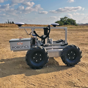
Image: Civ Robotics
Robotic Surveyor
Precisely marks thousands of coordinates per day
The CivDot unmanned ground vehicle (UGV) is designed for civil engineering and infrastructure projects such as solar farms, roadways, data centers, power plants and more. The autonomous surveying robot is designed to increase efficiency, productivity and safety on the job. Augmenting the surveyor’s work, CivDot marks thousands of coordinates per day precisely and efficiently, while delivering layouts faster than traditional methods. Civ Robotics uses Trimble’s high-precision GNSS positioning technology and surveying software.
The compact DJI Mavic 3E and 3T drones have been designed for an array of commercial missions. Flight time is 45 minutes. Both models have a real-time kinematic (RTK) module that enables surveying professionals to achieve centimeter-level accuracy with support for network RTK, custom network RTK services, and the D-RTK 2 Mobile Station. The D-RTK 2 Mobile Station is DJI’s upgraded high-precision GNSS receiver that supports all major GNSS, providing real-time differential corrections. The DJI Mavic 3E enables efficient mapping and surveying missions without the need for ground control points. The DJI Mavic 3T is engineered for aerial operations in firefighting, search and rescue, inspections and night missions.
Thales Alenia Space is a joint company between Thales (67%) and Leonardo (33%).
EGNOS enhances the accuracy, reliability and integrity of positioning signals by improving the performance of GNSS. For instance, the EGNOS safety-of-life service is used in aviation for landings, enabling precision approaches at European airports without requiring ground guidance systems. The service has significantly improved operational safety and efficiency for European aviation.
Thales Alenia Space will build on its expertise in engineering, development, testing and maintenance of the existing EGNOS, along with its current development of EGNOS V2, to provide maintenance of the EGNOS V2 system for EUSPA and the European Union satellite navigation community from 2023 to 2026.
Thales Alenia Space will provide operational support and servicing in case of incidents — especially hardware and software troubleshooting and repairs — to deliver optimal 24/7 support for EGNOS. In addition, it will provide the upgraded or modified versions needed to ensure safety-of-life service.
Paris Austin, head of product – New Technology for OxTS, tries out the new backpack at historic Minster Lovell Hall. (Image: OxTS)
More than 400,000 sites in the United Kingdom are on its historical registries. English Heritage site Minster Lovell Hall is located in Oxfordshire, also the home county of inertial navigation company OxTS. The picturesque ruins of Minster Lovell Hall, a 15th-century manor house, include the hall, a tower and a nearby dovecote.
The hall was built in the 1430s by William, Baron of Lovell and Holand — one of the richest men in England. It was later home to Francis, Viscount Lovell, a close ally of Richard III. After changing hands several times, the hall was abandoned and eventually demolished in the 18th century, leaving the extensive remains that stand today.
(Image: OxTS)
The buildings are grouped around a central courtyard in a plan characteristic of a late medieval manor house. For OxTS, the site proved suitable for testing its prototype backpack. The site features dense tree canopies on one side, tight doorways, narrow views of the sky, and plenty of height to test the angled mounting of the survey-focused lidar for when GNSS is denied. Open-sky areas allowed the OxTS team to return to real-time kinematic (RTK) surveying before moving on to another section of the site.
Reconstruction drawing of Minster Lovell Hall as it might have appeared in the 15th century, by artist Alan Sorrell. (Image: English Heritage)
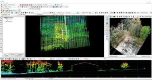
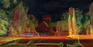
The prototype backpack is based on the OxTS setup for vehicles but was created to enable quick data collection without a car. It is equipped with two Hesai lidar sensors, a new OxTS prototype inertial navigation system and an antenna. The team can connect it to a laptop for configuration and to optimize lever arms and the boresight. Once post-processed with OxTS Georeferencer software, the point cloud below was produced.
OxTS designed the backpack to meet a growing need for localization and georeferencing in both GNSS-denied areas and those that cannot be reached by car, including the construction, environmental, conservation and heritage industries.
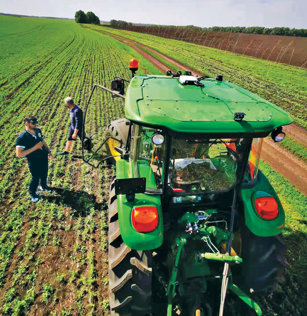
The earliest article about GPS and agriculture that I found in my collection of this magazine(*) is from the July/August 1992 issue: “Using GPS in Agricultural Remote Sensing,” by Eileen M. Perry of the Remote Sensing Research Laboratory of the USDA Agricultural Research Service. Thirty years later, you cannot buy a tractor from a major manufacturer that does not come equipped with a GNSS-based guidance system, and precision agriculture routinely makes use of remote sensing data and geographic information systems (GIS). The data are collected by Earth observation satellites, manned aircraft, UAVs and sensors on farm machinery. The GIS are used to collect, manage and analyze these data and create maps for the variable-rate machines to follow when seeding, irrigating, spraying fertilizer, herbicide and pesticides, and harvesting.
In this cover story, managers at Trimble, Tallysman Wireless, and ComNav Technology give their perspective on precision agriculture. Additionally, Gavin Schrock explains recently introduced options for tiered precise point positioning (PPP) services, using Trimble’s CenterPoint RTX as an example.
Proponents of precision agriculture and equipment vendors have always claimed that it reduces inputs (water, seeds, fertilizer and pesticide) and environmental impacts while increasing yields and profits. However, I have never been able to find any independent, reliable and comprehensive study of precision agriculture’s return on investment. If you are aware of any, please let me know, at [email protected].
— Matteo Luccio, Editor-in-Chief
Check out these perspectives on precision agriculture:
* I have the entire collection of GPS World’s print edition, except for the first issue, the 10 issues in the second year (1991), and the September through December 1993 issues. I would be thrilled to receive those missing issues, or facsimiles, from anybody who has them.
Correction services enable farmers to pinpoint where to apply fertilizers so as not to waste any. (Image: artiemedvedev/iStock/Getty Images Plus/Getty Images)
Growing among the many options for GNSS corrections open to precision agriculture operators are tiered precise point positioning (PPP) services. Agriculture has had integrated GPS, and now GNSS, for decades. Ranging from individual RTK bases, networks of RTK bases and network RTK (RTN) to dedicated L-band satellite-delivered PPP, operators have been able to receive and apply the appropriate corrections for different crops and applications, from centimeters to meters.
Part of the appeal of such services, particularly for large agricultural concerns with mixed crops and operations, is having the full flexibility of tiered precisions. Additionally, near-global coverage has increased utilization.
“Specialty and high value crops require high accuracy,” said Michael Helling, senior director of strategy for Trimble’s autonomy group. “For instance, when drip tape is laid for fruits and vegetables, you would not want subsequent activities to be off more than an inch or so, to avoid cutting it. This is where RTK was essential, and a base was often set up, or an RTN accessed. But the RTX [Trimble’s PPP delivered by L-band satellites] high-precision option, CenterPoint RTX, easily meets those needs.”
Like some other PPP correction services, Trimble’s RTX also has lower precision subscription options: RangePoint for 15 cm and ViewPoint for 30 cm pass-to-pass accuracy. These services are also utilized outside of agriculture. For example, CenterPoint, delivering centimeter precision, is utilized for certain surveying and construction applications and FieldPoint for asset mapping. Trimble has also developed embedded solutions, based on the same core technology for, among other things, maritime, robotics, autonomous vehicle, and assisted driving applications.
Certainly many agriculture applications can suffice with lower precisions, such as broadacre crops, where there may be no need to maintain row-to-row and year-to-year repeatability. Where some amount of overlap between passes is acceptable, coarse navigation at sub-meter to meter precision may be all that is needed. However, as Helling notes, precision becomes addictive, and as the field equipment becomes more capable of positionally topical functions, many operators are stepping up in levels of precision.
“Farmers are more precisely testing fields with all kinds of sensors and seeing where the field actually differs in soil and nutrient content,” said Helling. “There are different approaches and value propositions. One is saying I need to fertilize this area better so that I can get a better yield. There are also situations where a specific area of the field might only produce to a certain level. Farmers can pinpoint where those areas are to apply fertilizers so as not to waste it and optimize their bottom line.”
For many agriculture applications, the reality is that you have a tractor pulling some other piece of equipment through a field.
“Think about sprayers, forever behind a tractor,” said Helling. “Our equipment can control a lot of things around the rate, precisely targeting specific pieces of a field or row. When you start thinking about sustainability, being able to turn the spray on and off where you’ve already sprayed, you can avoid overspray.”
Sensor integration helps automate the process.
“We just aquired a company in France called Bilberry; their technology is very effective at identifying weeds. You can identify what’s in the field and can decide how you’re going to treat it. The next immediate steps in automation for agriculture might not be full autonomy, but more automation in the equipment that’s being pulled, and sensors that inform what they do.”
Tallysman antennas provide a critical link in the field for autonomous and semi-autonomous farm equipment. (Image: Kinwun/iStock/Getty Images Plus/Getty Images)
How do you define precision agriculture?
Precision agriculture includes all such modern technological advances as precise GNSS, robotics (autonomous vehicles, UAVs), sensors, and GIS that enable improved crop production by soil/field management and minimize the use of energy, seed, herbicides, pesticides and fertilizer.
What have been the key turning points in the development of precision agriculture?
There have been four key precision agriculture developments over the past 25 years. First, field mapping, which enables yield monitoring and the directed application of seed, fertilizer, herbicide and pesticide. Second, precision GNSS, which enables the same plus crop row offset from year to year. This offset, in turn, makes it possible to distribute the plant root system and utilize nutrients in different locations in the field, as well as to minimize soil compaction by ensuring that wheels do not travel over the same row from year to year. Third, autonomy, including UAVs and autonomous vehicles. Fourth, sensors to monitor moisture and water levels, and to identify weeds and plants.
What are the specific requirements and challenges of precision agriculture for GNSS, and how do they differ from those of other kinds of mapping and machine control?
Many precision agriculture applications require L-band corrections, which are typically broadcast from a geostationary satellite 35,800 km above the equator. The distance from the broadcast satellite to the user increases as the user travels either north or south of the equator. At the same time, the elevation angle decreases and at ~70° north or south of the equator the geostationary satellite will be seen at the horizon. As a result, at northern and southern latitudes, the L-band correction signal is seen at a low elevation angle and it is very weak because it has travelled a long distance. Tallysman has designed the VSS6037L antenna to receive L-band signals seen at low elevation angles.
When did Tallysman Wireless begin to focus on precision agriculture and why?
In September 2019, Tallysman Wireless released the VSS6037L agriculture and machine control GNSS antenna. Most GNSS/L-band antennas on the market have significantly lower gain at low elevation angles. Common GNSS antennas will provide good geostationary L-band reception from the equator to approximately 55° north or south latitude. However, as the arrival angle gets lower, a common GNSS antenna will have less gain and it will be challenged to receive the L-band signal at higher latitudes. Tallysman designed the VSS6037L specifically to provide support for all latitudes and specifically low elevation angle L-band signals received by users north or south 55° latitude.
What are your relevant products/product lines?
Tallysman Wireless has several GNSS antennas and smart GNSS antenna product lines that are designed for precision agriculture. The TW3972XF (triple-band plus L-band) and VSS6037L (full-band plus L-band) are ideal precision agriculture antennas. Tallysman has recently released the TW5390, which is a smart GNSS antenna that uses the u-blox F9P chipset and supports its PointPerfect L-band augmentation service.
For farmers, every centimeter counts. ComNav’s AG360 Pro autosteering system controls pass-to-pass accuracy within 2.5 cm. (Image: Daniel Balakov/E+/Getty Images)
How do you define precision agriculture?
Precision agriculture uses new technologies to obtain as much as possible the unique characteristics of a field and input the correct amount of resources at just the right time. It is a system that needs to be implemented throughout the whole process of crop growth, including land preparation, tractor guidance, water management and weather monitoring. Tractors are used at every step, therefore it is critical to make them work consistently throughout the whole process, by using GNSS. ComNav Technology’s autosteering systems can be installed on most types of tractors. This allows farmers to grow the crops in a more autonomous and efficient pattern, which they can then save with high precision and reuse for later steps until harvest, increasing the utilization rate of land and decreasing the use of fuel, water, fertilizer and herbicides.
What have been the key turning points in the development of precision agriculture?
We have been in this sector since 2013. Our current solution is much easier to install and maintain and has higher accuracy and stability. The younger generation of farmers are more receptive to autonomous driving. They would like to try new things and set themselves “free” with technology.
What are the specific requirements and challenges of precision agriculture for GNSS, and how do they differ from those of other kinds of mapping and machine control?
The main challenges for autosteering systems include signal loss and terrain compensation. Most rural areas lack GSM coverages; therefore, in many countries using autosteering requires base stations. However, radio data links between stations far apart could be affected by obstacles, causing frequent correction outages. To compensate for this, ComNav has embedded in its GNSS module its “RTK-Keep” algorithm, which can maintain a relatively high-precision performance for autosteering during corrections outages. The system also must include various terrain compensation algorithms that identify a field’s elevation contours and provide smooth and continuous guidance even in complex terrains.
When did ComNav begin to focus on precision agriculture and why?
In 2013, we introduced our first high precision GNSS board. Initially, our main role was to provide it to integrators with expertise in precision agriculture. Over the years, the market began to boom in China and in 2016 we announced our first generation autosteering system for tractors. The main reason for us to focus on precision agriculture is the increasing demand from the market, which we believe will continue to grow in the foreseeable future due to the increasing demand for food from Earth’s growing population.
What are your relevant products/product lines?
In the past, workers in China drew lines on the land and then planted potatoes roughly along those lines, which was challenging and time consuming. It was hard for the farm owner to hire an experienced driver and guarantee the effectiveness of seeding. Now, however, ComNav Technology’s AG360 Pro autosteering system solves that problem by guiding vehicles according to set routines, including straight lines, curves, automatic turns and headline turns. Importantly, the pass-to-pass accuracy can be controlled to within 2.5 cm. The worker can finish multiple processes within only 24 hours, such as ridging, ditching, sowing, fertilizing and laying drip irrigation under mulch. Furthermore, compared to traditional manual planting, mechanized planting produces a more even sowing rate, which also establishes the foundation for the automated harvesting of potatoes. Potato production has increased by 10% per acre, land use has been reduced by more than 20%, and labor costs have been reduced significantly.
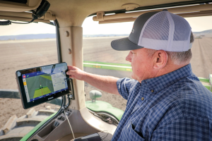
With the aid of Trimble’s correction services, the in-cab GFX-1260 display connects farmers to a wealth of knowledge about their fields and crops. (Photo: Trimble)
How do you define precision agriculture?
Precision agriculture is the use of technology in farming to increase yields through data and precision. Precision ag helps farmers improve yields by collecting data on all aspects of each plant to figure out exactly what it needs, when it needs it and how it will best survive. From planting, growing and cultivating to spreading, spraying and harvesting, precision agriculture allows farmers to monitor, measure and utilize data from beginning to end.
What have been the key turning points in the development of precision agriculture?
Accurate positioning is the enabler for all precision agriculture. RTK was one of the biggest initial developments within positioning as it allowed farmers a higher level of accuracy than had been seen previously. Precise Point Positioning (PPP) was the next big development. Our version of PPP, Trimble RTX, allows farmers the best of both worlds — RTK-level accuracy delivered via satellite, eliminating the need for base stations or sometimes unreliable radio, cell or internet signals. Though precision agriculture started with guidance, it has now made its way to implement-level, variable rate seeding and spraying and section control. ISOBUS has also been a big development in the past few years — allowing machines of all types to interact and communicate with each other, regardless of type, color and shape.
What are the specific requirements and challenges of precision agriculture for GNSS, and how do they differ from those of other kinds of mapping and machine control?
The challenge in GNSS is providing customers with the greatest availability in the field. While most fields are under open sky, obstacles such as trees and gullies make it more challenging. At Trimble, we provide market-leading pass-to-pass value with limited overlap for the customers at different price points. With our latest and most premium correction service, CenterPoint RTX, ease of use is also a key benefit.
When did Trimble begin to focus on precision agriculture?
Trimble unveiled its first agriculture receivers in 1999, signaling the start of the Trimble Agriculture division. In 2000, AgGPS Autopilot and automated steering systems were released for row crop application, further cementing Trimble’s presence in the precision agriculture community.
What are your relevant products/product lines?
Trimble offers technology integration that allows farmers to collect, share, and manage information across their farms, while providing improved operating efficiencies in the agricultural value chain. Trimble solutions include both hardware and software for guidance and steering, flow and application control, water management, harvest solutions, desktop and cloud-based data management, and correction services. Trimble’s CenterPoint RTX satellite-based correction service delivers GNSS positions repeatable to less than an inch. Combined with Trimble’s ProPoint GNSS technology, this service provides greater positioning availability, even in challenging environments such as tree lines, gullies and along contours where much of farming takes place.
For applications where centimeter-level accuracy is not as high of a priority, such as broad acre applications, Trimble RangePoint RTX and ViewPoint RTX give additional correction service options. They hold equipment to 6-inch and 12-inch pass-to-pass accuracy — or about the width of a tire between passing swaths. Trimble also offers Trimble VRS Now, giving farmers instant access to RTK positioning services using a network of permanent, continuously operating reference stations.
The high-accuracy service (HAS) offered by Galileo is now available and provides sub-meter accuracy over most of the globe. It will help enable emerging technologies such as UAVs and autonomous vehicles, which require stringent levels of accuracy for better navigation, safety and efficient traffic management.
Other industries expected to benefit include transportation, agriculture, geodesy and entertainment.
Thierry Breton, European commissioner for Internal Market, announced that the service was now live during the annual European Space Conference in Brussels, Belgium, on Jan. 24.
The European Union Agency for the Space Programme (EUSPA) developed Galileo HAS along with the European Commission and the European Space Agency (ESA). The new service will become a pillar of government programs such as EU sectorial policies and national policies by EU Member States.
“This new service has been made possible thanks to the outstanding cooperation and team commitment of all involved partners,” said Rodrigo da Costa, EUSPA executive director.
“Galileo is not standing still,” said Javier Benedicto, ESA director of navigation. “This new High Accuracy Service offers a new dimension of precision to everyone who needs it, while the Open Service Navigation Message Authentication — already available — allows users to authenticate Galileo signals as they make use of it, to minimize any risk of spoofing. An upgraded integrity message of the signal rolled out last year reduces the time to first fix while enhancing the overall robustness of Galileo.”
Galileo HAS delivers horizontal accuracy down to 20 cm and vertical accuracy of 40 cm in nominal use conditions, according to ESA. The service is transmitted directly via the Galileo signal in space (E6-B) and through the internet.
With HAS, Galileo becomes the first constellation worldwide able to provide a high-accuracy service globally and directly through the signal in space.
The service is freely accessible to all users with a receiver capable of processing the HAS corrections broadcast in the E6-B signal and via the internet. The precise corrections provided by Galileo HAS will allow users to reduce the error associated with the orbit and clocks provided through the Galileo Open Service broadcast navigation messages and the GPS Standard Positioning Service navigation data.
“With the Galileo HAS we are ready to unleash the full potential of new technologies such as drones and bring autonomous driving closer to reality,’’ da Costa said. “At EUSPA, our role is to link space to user needs. With the launch of this new service, we met a clear market demand for accurate, robust, and reliable navigation.”
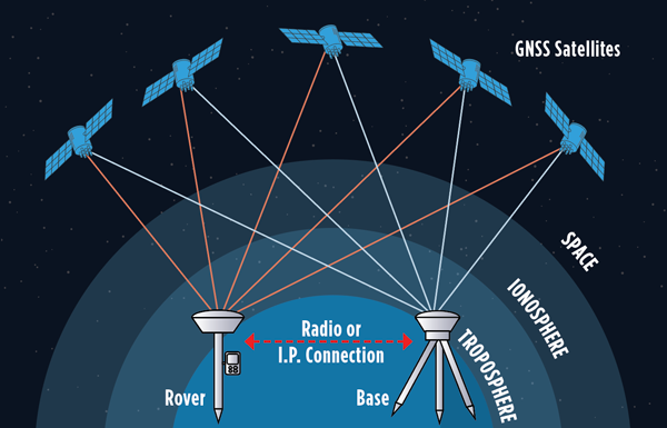
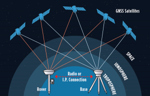
While single-base real-time kinematics RTK can, under specific conditions, be the best option for certain applications in surveying and construction, corrections services typically eschew this solution in favor of network RTK, PPP, and PPP-RTK. There are, though, some agricultural networks made up of clusters of reference stations delivering RTK corrections. (Images: courtesy of Gavin Schrock and Courtney Townsend Bigmouse108/iStock / Getty Images/Gettu Images)
The boom in the development of corrections services for applications such as autonomy and robotics has brought a whole new slate of market players, and an expansion of services from established corrections providers. This has benefitted high-precision users as well as the new not-so-high-precision applications.
Whereas very high precision — centimeters — is of paramount importance to sectors such as precision agriculture, construction automation, surveying and mapping, new market sectors are less concerned with precision as they are with reliability, availability and resilience. There are many corrections services that can deliver reliable lane-level precision, decimeter precision, sub-meter or whatever the application requires.
Corrections have been around in various forms for nearly 30 years. Whereas traditional high-precision applications would access corrections services or network infrastructure directly, the user of a mass-market application, such as assisted or autonomous driving, receives corrections second or third hand.
A car manufacturer may install an integrated navigation and positioning system (GNSS is typically only one of many technologies in a complete system) from a vendor that receives corrections from one or more corrections services.
A Recap of the Technology
Uncorrected GNSS is limited to precisions in meters. This may be fine for many purposes, such as coarse navigation and local-based apps. However, for high precision uses, external augmentations (commonly referred to as “corrections”) add more and higher accuracy data to help mitigate multiple sources of error that otherwise limit standalone GNSS results. Various augmented data can be delivered via radio, the internet, or communications satellites. Delivery of augmentations by public or commercial generators of this add-on data is broadly referred to as “positioning services.”
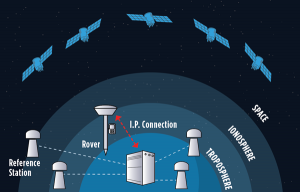
Network RTK, implemented as real-time networks (RTN), covers hundreds of localities, states, and entire countries and is a go-to for many applications in surveying, mapping, construction, monitoring and agriculture. One disadvantage, compared to PPP, is reliance on terrestrial IP communications. (Images: courtesy of Gavin Schrock and Courtney Townsend Bigmouse108/iStock / Getty Images/Gettu Images)
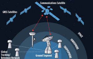
There are two fundamental approaches to generating corrections: Observation Space Representation (OSR) and State Space Representation (SSR). OSR uses observations of one or more base receivers to derive correction values representative of local conditions. Examples of OSR include base-rover real-time kinematics (RTK) and network RTK (NRTK). SSR provides “states” of conditions derived from terrestrial tracking networks, to improve clock and orbit “products,” and may also include data from global, regional, or localized ionospheric and tropospheric models. Examples of SSR include precise point positioning (PPP) solutions.
Players in the corrections services sector include vendors who manufacture GNSS hardware, RTK systems, and NRTK software. One example is real-time networks (RTN), which have grown to cover hundreds of localities, states, regions, and even entire countries. Some of these vendors now operate their own wide region RTN. The same large vendors also have developed global PPP services. The most recent decade though has seen rapid growth in new corrections service providers that focus on one or more key markets and develop approaches specifically to serve them. For instance, many agricultural regions of the world have large clusters of RTK stations operated by a vendor or a cooperative. Some newer vendors, focused on the autonomy market, have developed global PPP services, regional NRTK, or hybrids for decimeter to meter precision. One Achilles heel of PPP is its relatively poor vertical precision compared to RTK and NRTK. This partly explains why adoption has been slow for certain high-precision applications, such as surveying.
Where corrections services have become quite interesting, is in amalgams of these approaches. In recent years, the rapid expansion of corrections services for mass-market applications has given rise to what developers call PPP-RTK. Ostensibly, this is to take advantage of the strengths in each approach, however it may be more about trade-offs between precision and the practicalities of serving wide regions in a cost-effective manner. There are many variations on how this hybridization is achieved; for example, PPP- ambiguity resolution (PPP-AR). PPP-RTK can be somewhat of a nebulous term, much in the same way as the term “AI” gets used. Developers of the specific PPP-RTK approaches for the many corrections services keep certain details close to their chests. Clients are less concerned with how it works as they are with the results.
Examples of Vendors
In compiling the following list, we tried to provide examples of all aspects of the corrections service industry — from GNSS network software development to hosting of national and regional networks to providing global PPP. This segment continues to grow; new players continue to develop solutions and enter the market, some with great fanfare, while others seek to stay under the radar. This list does not include the many hundreds of RTN worldwide — local, regional, or national — though the key providers of the NRTK software these networks use are listed.
One advantage of PPP and PPP-RTK over RTK and NRTK is that they can deliver augmentations by satellites, eliminating reliance on terrestrial communications networks. Satellite delivery has a downside: the number of communications satellites broadcasting the augmentations is limited, which can be problematic in sky-view challenged areas. (Image: courtesy of Gavin Schrock and Courtney Townsend Bigmouse108/iStock / Getty Images/Gettu Images)
Note that other vendors are also not listed, such as some that seek to limit their visibility to specific clients and partners. For example, some offer corrections services as an adjunct to inside hardware/software sales, and others work with developers of certain integrated navigation/autonomy systems. In addition, some of the smaller vendors may be working in conjunction with some of the more established developers, often licensing elements of their software, and in many instances piggybacking on their global tracking networks.
In alphabetical order: Atlas. From Hemisphere GNSS. A global PPP service delivered by L-band satellites. It includes tiered precision for different applications, such as surveying, mapping, and asset management. Atlas Basic, Atlas H30, Atlas H10: bit.ly/3V42qxj. CHCNAV. CPS NRTK software: bit.ly/3FI6zlN. It also hosts various RTN and has a global network partner program: bit.ly/3VQugOr. CNH. Advance Farming Software (AFS) RTK+ network delivering corrections mostly via cellular to primarily precision agriculture users: bit.ly/3YiCZur. DigiFarm. DigiFarm VBN. An example of another network that serves primarily agriculture users, however, it now has a spinoff to serve other high precision markets: bit.ly/3hgnYZs. eSurvey. GNSS NET, a VRS management software: bit.ly/3Py0uMp. Fugro. Global PPP corrections services; tiered precision for various applications, mostly maritime and marine construction. StarFix, SeaStar, MarineStar, OceanStar: bit.ly/3W4LkA8. Geo++. One of the first developers of GNSS network and PPP solutions. Its GNSMART software suite provides NRTK and SSR broadcast capabilities: bit.ly/3FhGE2Z. HERE Technologies. HD GNSS, a PPP-RTK solution for mass-market applications: bit.ly/3Fnle4H. Hi-Target. Hi-RTP, a global PPP- RTK service: bit.ly/3hi2xHv. IGS. International GNSS Service, a federation of agencies and research entities with a global tracking network of more than 400 reference stations. The IGS is a vital component of the global geodetic infrastructure. RTS is its real-time PPP service. It is not fast converging like many of the commercial services, but it is free for many applications. It is not broadcast via satellites, only via the internet: igs.org. Leica Geosystems. Part of Hexagon. Provider of NRTK software (Spider), and host of its own RTN covering various regions around the world (SmartNet), and global PPP (SmartLink): bit.ly/3uEwHb9. NovAtel. Part of Hexagon. Includes various tiers of PPP-RTK: RTK Assist, RTK Assist-Pro*, TerraStar-L, Oceanix, TerraStar-C PRO*, and TerraStar-X* (what NovAtel calls“RTK From the Sky”): bit.ly/3HzuqWh. Point One. RTK correction service called Polaris, available also via partners such as Bad Elf: bit.ly/3uPJGqA. Premium Positioning. RTKcorrections service called RTK Premium: bit.ly/3uT0xZi. Rx Networks. A mix of tiered positioning approaches for location- based applications. Truepoint. io (DGNSS, PPP, PPP-RTK): bit.ly/3We1rvT. SBAS (Public). Satellite-based augmentation systems, national or regional services. Like commercial PPP, SBAS corrections are mostly served via satellites. Public safety and civil aviation are the primary drivers for providing such services. For instance, in North America, the Wide Area Augmentation System (WAAS) was chartered by the Federal Aviation Administration (FAA). There are equivalent systems in Europe (EGNOS), India (GAGAN), Japan (MSAS and QZSS), Russia (SDCM), China (SNAS/BDSAS, which is still in development) and Australia and New Zealand (SouthPAN). Other systems are in development in South America and the Caribbean (SACCSA), Korea (KASS) and in Africa and the Indian Ocean (ASECNA). Sino/Comnav. CDC.NET CORS software, RTN software: bit.ly/3W56hvm. Swift Navigation. Skylark RTK and Skylark DGNSS services: bit.ly/3HyWVn5. Tersus GNSS. Tersus Advanced Positioning (TAP), a PPP service: bit.ly/3hoZkWD. Topcon. TopNet and Topnet Live. RTN Software, regional RTN, and PPP services: bit.ly/3FRRcaw. Trimble. RTN software, VRS Now (regional RTN), and tiered PPP services: CenterPoint RTX, RangePoint RTX, ViewPoint RTX, and FieldPoint RTX: bit.ly/3V3bbax. u-blox. PointPerfect regional PPP and PPP-RTK: bit.ly/3FPVmQo. Veripos. Part of Hexagon. Tiered global PPP services, originally focused on maritime applications: Standard, Ultra, APEX: bit.ly/3BBjfsf. Verizon. Telecom infrastructure-based PPP-RTK service called ThingSpace: bit.ly/3Fw1U55. Vodaphone. Currently developing corrections services in conjunction with Topcon: bit.ly/3Pug4s0.
Whatever the application, there are now many options for corrections services. Non-mass-market applications, for traditional high- precision uses, have been tapping such services for (in some cases) decades. The prize of primacy in the autonomy market has been in the sights of many of these vendors for many years, yet there have been relatively few real-world applications to date. That should be changing soon. Early adoptions such as GM’s Super Cruise, which is powered by the same core PPP technology as RTX, have been quite successful. Which will come out on top? That might be a moot question. With the potential of such markets so great, perhaps there is room for all of them, and more.