Providing high-speed internet access to businesses and residences is a highly active and expanding field. It closely involves geographic information systems (GIS) to efficiently achieve fiber to the home (FTTH) or fiber to the premises (FTTP), the installation and use of optical fiber from a central point directly to individual buildings such as residences, apartment buildings and businesses for high-speed internet access.
A free webinar on Jan. 18 will cover — among several other related topics — the integration of high-accuracy aerial imagery into this process. David K. Nelson, GISP, a GIS manager in telecommunications for Black & Veatch, will make the presentation. It will be complemented by a talk on how to “Plan Virtually, Manage Efficiently with High-Definition (HD) Aerial Maps” by imagery provider Nearmap, and one on use of HD aerial imagery for city storm-water management.
David Nelson, GIS manager, telecom, for Black & Veatch
Nelson is responsible for developing GIS solutions for projects with the Black & Veatch’s telecommunications division. With over 13 years of experience in public and private sectors, Nelson is a visionary for adopting and enabling geospatial technologies and location content that drive operational efficiency. His presentation will cover such topics as GIS-centric approach for all projects; file-based vs. data-based transition; geospatial archives of all data; and integration with other technology platforms.
In a case study, he will take webinar attendees through a FTTH project design and execution example.
Black & Veatch is an engineering, consulting and construction company with more than 100 offices worldwide, specializing in infrastructure development in power, oil and gas, water, telecommunications, government, mining, data centers, smart cities and banking and finance markets.
FTTH project: fiber to the home. (Image: Black & Veatch)
The annual Black & Veatch Strategic Directions: Smart Cities & Utilities Report explores progress made across the smart city and smart utility landscape. This year’s report examines how modern, digital infrastructure is being used to optimize operations and create a sustainable future for our cities and utilities.
“From urban mobility to the proliferation of electric vehicles, transportation is changing rapidly, inviting opportunity in how people and goods move across cities. The next generation of wireless technology is upon us, further encouraging connectivity and enabling smart cities in myriad ways. Grid modernization continues as utilities work to create a customer-centric grid through a combination of smart devices, distributed energy and communications.”
Advances in aerial imagery including high-resolution maps and a streamlined process to capture, manage and deliver imagery in the cloud is transforming the way governments and businesses operate. With Aerial photography and instant access to current 2.8-in. GSD aerial views, Black and Veatch has increased efficiency in their telecommunications projects including assessment of ground conditions, construction and asset management. In Indiana, The City of Carmel’s Engineering Department has applied aerial imagery to enhance planning, operations and storm water management.
In this webinar, you will:
Learn about the latest advances in aerial imagery including how imagery is supporting a variety of government and business applications today
See real-world use cases of imagery in telecommunication, engineering and city government to improve operational efficiency
Understand how imagery can be used standalone and within GIS and CAD products
See the latest demos of Nearmap imagery including vertical, panorama and oblique views
Drone Delivery Canada (DDC) is expanding its commercial testing program to the United States at the New York Griffiss International Airport unmanned aircraft systems (UAS) test site in Rome, New York.
DDC anticipates that the U.S. Pilot Program will begin in this quarter of 2018 and run through the balance of the year.
The new initiative expands DDC’s testing program to include geographies within the U.S. using its Sparrow X1000 drone, which achieved Compliant UAV Status with Transport Canada in December 2017.
For testing, DDCs will use its proprietary FLYTE management software to support semi-autonomous flight, as well as BVLOS (beyond visual line of site) flights designed for commercial drone deliveries.
The Griffiss International Airport UAS test site in Rome is a Federal Aviation Administration (FAA)-approved facility designated to conduct research vital to integrating UAS into the national airspace system. The site is the fifth of six test sites that are operational in the U.S.
The U.S. testing initiatives will complement DDC’s extensive Canadian testing program scheduled for 2018, which will include testing its BVLOS capabilities at the Transport Canada-approved UAS Centre of Excellence in Alma, Quebec.
As another holiday season passes us by, it is customary to look back at the year and recall the trends, new products and services, and breakthroughs we experienced with the GNSS environment and its effect on the professional surveyor. While 2017 was not filled with groundbreaking instruments and programming, it did provide a good look at what are going to be trends and gamechangers for the near future. From new innovations on GNSS receivers, new UAV platforms, and geospatial advances, it was also a year that saw location spoofing of shipping vessels, trade relations among super powers being tested, and more opportunities to put satellites into orbit from the private sector. Let us look back at what the surveying community experienced with the GNSS industry:
The constellation scorecard
GNSS continued to expand to all reaches of the globe with enlargement of existing constellations along with introductions of several new ones, (see GPS World magazine “The Almanac,” December 2017). The European satellite system, Galileo, has led the expansion with four (4) new vehicles. This joint venture of the European Commission and the European Space Agency was declared operational at the end of 2016 and looks to keep increasing its coverage in the coming years. For surveyors, this means additional redundancy for our positional data. More confirming redundancy translates into increased confidence in our work product.
Next in numbers of vehicles being sent to space is the Japanese effort named Quasi-Zenith Satellite System (QZSS) and operated by the Japan Aerospace Exploration Agency (JAXA). While their first bird was sent up in 2010, this was the breakout year with three (3) more satellites installed this past year. It is anticipated that the constellation will be operation in 2018 and we can expect most of the GNSS manufacturers to include the positional data from QZSS if they haven’t already built in this capability.
Coming in next are the Chinese with their regional-based system called BeiDou with two (2) more satellites installed in 2017. Their current program is scheduled to have several more vehicles included in the constellation and provide worldwide positional coverage by 2020. With the rapid expansion of China as a world leader, we can anticipate more GNSS developers to work closely with BeiDou as the system becomes more effective on the global stage.
The other world leader, Russia, continues their expansion of GLONASS with the installation of one (1) new satellite in 2017 with plans to upgrade several existing vehicles in the coming years. The inclusion of GLONASS signal reception by survey-grade GNSS receivers has greatly increased the redundancy of data collection, (as mentioned with Galileo). It has also expanded our timeframes in which we can work with reliable positional solutions, thus keeping our downtime to a minimum.
The United States is by no means bringing up the rear in GNSS constellation development but 2017 was a transitional year for the program. A new government administration has led to revisiting our national budget, with the Department of Defense looking to prosper under preliminary plans. While the schedule for constellation expansion have been in place for several years, the installation of Block III satellites has become a higher priority. These satellites will provide higher positional accuracy than previously experienced without any correction signal utilized. This will help the surveyor with better positional accuracies in shorter timeframes and looking forward to its expanded capability.
Once these constellations are operational (with more to come), the ability to record positional locations and attribute data will be greater than ever. A potential challenge to these satellite constellations, however, is the ever-growing fear of potential conflicts between the United States and several countries, including North Korea, Syria, Iran, and Russia. The threat of nuclear war with North Korea could result in our GPS network being shut down to civilians or blocked by an electromagnetic pulse weapon. Cold War tactics with Russia could lead to spoofing or blocking of GLONASS signals that many of our GNSS receivers have become reliant upon. There are alternatives being developed in case our GPS goes away (see “The Day GPS Went Away,” September 2017) but we are several years from having a true secondary option. We will need to keep our fingers crossed we can maintain peace across the globe but do not look forward when something happens and takes our GNSS ability away.
Data mining and the surveyor
One thing that has emerged from 2017 has been the importance of data; where it is housed, how we use it, and what it can tell us about our future endeavors. GNSS has revolutionized the data mining industry with the surveying industry being right in the middle of the fray. Prior articles were published about geolocation (see Geolocation and the surveyor: Looking back to the future) so the rapid expansion of the data collection into most business environments shouldn’t surprise most readers, especially if one reads technical sources like GPS World magazine. The surveying community has watched and experienced the astronomical growth of this data collection in various arenas, none of which was more obvious than the “Geospatial 4.0” initiative at Intergeo 2017 in Berlin, Germany. While summarizing to readers on a trip through the annual conference in the last article (Intergeo 2017: A surveyor’s perspective), it was also here that a bigger picture was coming into focus regarding data and its effect on our world.
While doing homework for this article, the term “Geospatial 4.0” was coined for the 2015 Intergeo conference in Stuttgart, Germany. This term was developed by the conference team regarding the advancing developments in the data world that incorporate geolocation, time, and unlimited information attributes, all while stored in a central location “in the cloud.” This environmental condition exists for most us already, as it is estimated there are three to four billion smartphone users worldwide. The data that is being collected every day is a small part of how our lives and relative actions have become digital snapshots to assist those charged with forecasting and planning of our future cities and environments. Much of this data is being used to advance the places where we live through an initiative called “Smart Cities.” Installation of data collection sensors and control systems in various applications monitor and store information to help make necessary changes to the existing systems. The organizations and municipalities behind this effort are attempting to create better work and home environments with increased efficiency and sustainability.
The professional surveying community plays a big part in the continuing development of geospatial world around us. Our job is not only to collect data for a boundary survey, topographical information for an engineering design, or provide layout assistance for construction; we are also historians in establishing the current positions of required information at a specific point in time. The world around us can move quickly, so providing the precise moment in time when data is collected is sometimes just as important as the location itself. Our role as surveyors becomes even more important as the increased development and implementation of geographical information systems (GIS) emerges within more public and private entities. Where the surveyor previously shunned being included within the collection process and framework of GIS, our profession has become quite efficient at the data acquisition and database maintenance necessary for geospatial success.
The surveyor’s friend in the technical world of geodesy, the geodesist, has not always been an accepted member of the GIS world, either. Once seen as mathematicians stuck in laboratories calculating “perfect world geometric solutions,” the geodesist carries a significant amount of beneficial information to the realm of geospatial data. It has been through their data collection and research that has brought our shifting continents to light and the simple fact our land-based coordinate systems must be modified to change positions as time rolls along. The common theme here is that spatial data comes down to several distinct factors: position, navigation, and time.
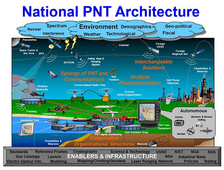
PNT (not just another dull government acronym…)
Another big step forward taken in 2017 was the continued implementation of positioning, navigation, and timing, otherwise known as PNT. These three bits of information provide the geographic basis of collected data for any GIS or other environmental study. According to the U.S. Department of Transportation website, here is the definition of PNT:
“…a combination of three distinct, constituent capabilities:
Positioning, the ability to accurately and precisely determine one’s location and orientation two-dimensionally (or three-dimensionally when required) referenced to a standard geodetic system (such as World Geodetic System 1984, or WGS84);
Navigation, the ability to determine current and desired position (relative or absolute) and apply corrections to course, orientation, and speed to attain a desired position anywhere around the world, from sub-surface to surface and from surface to space; and
Timing, the ability to acquire and maintain accurate and precise time from a standard (Coordinated Universal Time, or UTC), anywhere in the world and within user-defined timeliness parameters. Timing also includes time transfer.”
The basis for PNT can be used for any data collection. From fixed monuments utilized by surveyors to any municipal utility installation, the use of PNT now becomes an important part of the GIS database, if not for anything more than simple tracking. By establishing the location of any entity at any given time and comparing its position to an earlier collection, we can determine the navigation of that entity. A good example of PNT and our daily interaction is the satellite navigation systems installed in our phones and vehicles. When we utilize our favorite mapping program on our phone or in our car, we are implementing a PNT system to show us where we are, how fast we are going and help determine how soon we will be getting where we are going. This wonderful practice is being made possible by GNSS data collection and computer processors turning the positional data into useful information.
Surveyors are doing the same thing by the data collection they are performing every day. Any data that is collected by a modern survey instrument is being tagged with two of the main components of PNT; position and time. When the same entity is collected again later, its navigational information can be determined if needed as well. This type of data collection is becoming more apparent with laser scanning and lidar point clouds, as this data can be revisited to determine how much entities within the project area has changed. I foresee a time in the not-to-distant future where much of the Earth is scanned for historical purposes and can be analyzed by future generations for changes. A surveyor could benefit greatly by knowing where a water feature (rivers, creeks, streams, and lake and ocean shores) existed at a specific point in time and how much it has changed over time. Many land boundaries are based upon these water features as natural delineators, so knowing how much title area has changed with the natural movement of a waterway would be very beneficial to the surveyor and how land boundary disputes are handles. Same could be said of buildings and other improvements within developed areas, too. By establishing geospatial data on physical improvements, it could greatly help the surveyor determine historical and future land boundaries by their known location.
The simple fact is that our ability to collect, analyze and retain geospatial information has never been greater than now and only gets better over time. The surveyor now has similar tools to other sciences and technologies, so now is an appropriate time as any to truly embrace geospatial data collection.
UAV’s continuing growth
One market that continues growing at rapid pace is the unmanned aerial vehicle (UAV) sector. 2017 brought more aircraft innovations and expansion of sensors available for a multitude of data collection purposes. This greatly expanding segment of specialized equipment was quite evident at Intergeo 2017, where over 150 UAV vendors were provided their own space solely for the exhibiting as well as an outside arena for demonstrations. While there are other UAV trade shows that rival in the size, the Intergeo show brings the best vehicles, software and ideas for geospatial data collection and imagery directly to the surveyor’s hands.
Other innovations that are taking shape in the UAV world include larger multi-rotor aircraft with increased payloads, vertical takeoff and landing (VTOL) platforms, and a plethora of sensors designed specifically for UAV use. These modules include various methods of lidar for high accuracy scanning, hyperspectral cameras for analyzing plant characteristics, infrared scanners for heat detection, along with camera possibilities that are endless. The main reason to highlight these high-tech applications is simple; these technologies consist of location-based data collection. The surveyor, known professionally as the expert measurer, should make themselves more aware of the rapidly expanding ability to collect data of varying types new to the land surveying field but still relies heavily on accurate and precise measurement methods. The UAV, while still new to many surveyors, is becoming a standard measuring tool in our world. These latest sensors are a result of applying emerging technology for non-traditional surveying clients directly into our wheelhouse. The professional surveyor successfully adapted to new methods and instruments when electronic distance meters, GNSS receivers and laser scanners were introduced, so our profession needs to step up again and take note of what data collection methods and challenges are out there.
Wingtra One in the air. (Photo: Wingtra)
Staying on the subject of surveyors and the UAV, one of the next breakthroughs will be the introduction of affordable aircraft with RTK capability. There are currently several manufacturers of survey-grade UAV aircraft but these are sold at higher price point that is considered out of reach for the typical surveyor. Many have relied on less expensive models in conjunction with their existing RTK receivers to collect physical points or features for use with post-processing software. While not resulting in immediate data for project review, the end product of the post-processed method is quite good and at much lower cost of entry. However, there are times and places where ground control is not available or accessible so flights with photos or scans are not possible. The mainstream UAV manufacturers are taking note of the need for RTK capability and beginning to introduce models with this positional feature, so maybe the tide is turning to lowering the price point for this technology as well. Here is another place the surveyor will need to enter the UAV arena as the long-time RTK expert and utilize the latest technology for expanded data collection purposes. To my fellow surveyors: you’ve been warned, so be ready to get your checkbook out in order to stay competitive.
Survey-grade GNSS receivers
While 2017 wasn’t a breakout year for radically new GNSS technology, it did see its share of minor yet significant improvements. Along with the expansion of existing constellations and preparation for new ones, the technology behind the microprocessor within the GNSS receiver continues to allow for miniaturization and increased speed and accuracy. Several manufacturers are producing survey-grade receivers capable of acquiring hundreds of GNSS signals yet fit in the palm of your hand. Batteries, like most technologies using it, continues to decrease in size yet gain in power-up time. This rapidly shrinking footprint of the GNSS receiver is allowing for placement in more devices and places so the surveyor will need to take advantage of these gains to assist with providing positional and data collection expertise.
A sector of the positioning market that will see rapid increases is the smartphone division. Coupled with the growing GNSS constellations with increasing accuracy signals and more sophisticated computing power programmed specifically for positioning, we will see more smartphones being used for data collection purposes. Google has made significant strides in the customization of the Android operating system to allow for the processing of raw GNSS data to provide positional accuracies beyond the normal smartphone capability. It is safe to say that Apple is likely working on the same type of application for the iOS operating system, so we could see another battle for smartphone supremacy be waged on a highly technical front that surveyors can readily use for their profession.
Another advancement in GNSS technology that will see more in 2018 and beyond will be the use of the inertial measurement unit (IMU) in conjunction with receivers and sensors. Several manufacturers have incorporated IMU’s into their measuring devices to augment the data being collected. The application that has surveyor’s attention is a GNSS receiver with an IMU to record the measurement correlation of the pole tip to the center of the antenna. The IMU has also been configured on various vehicles built for mobile data collection to measure velocities and acceleration to assist with reducing errors within the GNSS measurements by environmental factors. As GNSS receivers continue to evolve and reduce in size, it will also allow for further inclusion of an IMU to help with reduce data errors. Surveyors should take note of these advancements and be prepared to upgrade their equipment and knowledge to stay current with emerging technology and data collection accuracies.
VectorNav’s new Tactical Series includes the VN-110 IMU/AHRS, the VN-210 GPS/INS and the VN-310 dual-antenna GPS/INS.
Into 2018 and beyond…
Some of the items worth watching in the immediate future include:
Autonomous travel
From Elon Musk’s Tesla projects to the Uber/Volvo collaboration with driverless vehicles, autonomous travel will dominate tech news for the next few years. Because these vehicles rely heavily on GNSS positioning in conjunction with road-reading sensors, the focus on the GNSS constellations will stay very much in front of the tech and political worlds. Another portion of the driverless equation is the effective mapping of the roadway system, which come right back into the realm of the surveyor. While we see various mapping vehicles (Google, Apple, and others) out and about digitizing our roadways, the surveyor is the professional entity that is relied upon for the location establishment for existing and future rights-of-way. Our inclusion in mapping these byways is critical to minimizing harm to the public for potential accidents and disasters.
Lightsquared 2.0
The battle over bandwidth several years ago seemed to end with the FCC denying the implementation of ground-based signal amplification by an upstart firm known as Lightsquared. Now with the new administration at the FCC and an atmosphere of deregulation, the firm has rebranded itself as Ligado and is back to try again. Hopefully the same coalition that helped defeat the prior attempt will be back, but with the new ideology running the FCC, all bets are off. The surveyor without GNSS capability (as previous discussed) will mostly be rendered lifeless without it.
Internet of Things (IoT)
Also fighting for bandwidth is a new generation of sensors and monitors being used for a multitude of products and procedures. This movement toward automation is proving to be useful in many environments but is beginning to tax an already overworked data stream. These components are more appropriate in mostly urban areas where broadband coverage is most effective but their implementation in rural America is starting to drive a greater need for more data availability in harder to get places. This push to get more broadband into rural areas will be a wonderful opportunity for those surveyors to complete their projects with similar effectiveness their counterparts in the urban areas already utilize. But the move by the FCC to repeal net neutrality poses a significant threat to that opportunity and equality, so we must wait and see how this plays out as well.
Final thoughts…
While covering a lot of ground here, the main thread is to emphasize the important link between the professional surveyor and the use of GNSS equipment and procedures. Prior to most of the emerging technology, the surveyor was relied solely for boundary determination and not much else. As engineering design became more reliant on detailed topographic surveys, the surveyor increased their responsibility to provide that vital information. As measuring and positional determination has become more complex, the surveyor has adapted to technology and provided that expertise in their duty to protect the public’s interest. Our world is getting more complex every day and we rely on specialized professions for a multitude of tasks. The surveyor can and should be relied upon for tasks discussed herein but making sure both the surveyor and the public knows that is a big key to success. Accurate positioning and reliable measurements requires someone with the knowledge of the subject and technology and the professional surveyor is that someone. To my fellow practitioners; stay involved, advance your education, and continue to be professional.
Drone operational rules have quite a few restrictions, largely aimed at keeping unmanned aircraft away from manned and commercial aircraft operations. The Federal Aviation Administration (FAA) has set a boundary limit for UAV operations to stay a minimum of 5 miles away from any airport. So it’s a little surprising that at least one airport is actually carrying on trials to fly drones within airport property.
The reason is birds. Most airports are large, open spaces where birds love to land in large numbers to seek food and to rest, so airports and aircraft have to cope with the problem of avoiding bird-strikes in the critical phases of take-off and landing.
Airports have used remotely compressed air cannons, and manually fired ordinance that “screams” or explodes making various forms of loud noise, or dogs or even hunting falcons of different species. Birds, however, become habituated to cannons and guns, and neither dogs nor hunting falcons can be relied on to actually herd birds away from runways.
All this is in an effort to drive flocks of birds away from runways and low-altitude aircraft traffic corridors. At high altitude, a bird strike is usually survivable and an aircraft still has sufficient energy to be able to glide in the event of a complete engine-out situation, giving the pilot time to find a landing place. U.S. Air’s Chesley Sullenberger was a great airman to save his passengers and aircraft, but he was also lucky to have the Hudson right there to ditch into. He was some cool dude when he put his Airbus A320 down on the river, once losing both engines at low altitude on take-off after flying through a flock of Canada Geese.
Enter Robird, a drone that looks — and behaves, in the right operator’s hands — like a female peregrine falcon, with flapping wing propulsion and attack moves emulating the predatory bird. Flown by a pilot and accompanied by an observer whose primary job is to ensure the UAV “bird” stays away from runways, the pair seeks resting flocks of birds that pose risk to aircraft within the boundaries of an operational airport.
https://youtu.be/-gc8kBmzOOI
Clear Flight Solutions in Holland has recently undertaken a trial at Edmonton airport in Alberta, Canada, where it obtained special flight clearance to fly within the airport grounds to demonstrate how its mechanical falcon could clear birds away from airport danger zones.
Of course, drones and aircraft don’t mix either, so flight rules within the drone systems (GPS/autopilot?) apparently include geofenced no-go areas corresponding with runways and approach areas, and there is a shutdown mode in case of loss of signal or other failure — avoiding runway incursion is all important.
Registration is back on
Since U.S. Federal Aviation Administration (FAA) regulations requiring registration of small UAVs (sUAV) and model aircraft were struck down last spring by the appeals court, the need to register has been in abeyance. However, Congress has rolled a new requirement back into the recently signed $700 billion National Defense Authorization Act, making registration of any sUAS or recreational model aircraft a legal requirement, subject to fines for lack of compliance.
The FAA has continued to advocate registration as a means to track wayward operators and to enforce separation of drones from manned aircraft. AUVSI has also continued to support the FAA position. A 2012 law, on the other hand, was said to prevent the FAA from making rules covering “model aircraft,” defined as “unmanned aircraft” flown for recreational purposes.
The new regulation within the Defense Authorization Act has now apparently clarified and overcome any contradictions — recreational model aircraft and drones all have to be registered.
DJI claims and counter-claims
The U.S. Immigration and Customs Enforcement’s (ICE’s) recent claims that manufacturer DJI could be spying for the Chinese Government have been refuted by DJI.
DJI has responded that allegations are wrong and that ICE should consider withdrawing or correcting unsupportable assertions. But claims persist that the Chinese government may be using information gathered by DJI UAVs to target potential assets for purchase.
A large wine producer in California used DJI UAS to survey its vineyards and monitor grape production, but soon afterwards a number of Chinese companies apparently purchased vineyards in the same area. So it’s being alleged that the companies appear to somehow have used DJI data.
DJI UAVs collects reflective images of leaves to calculate the nitrogen levels of plants using a specialized infrared scanner. The scanner enables growers to deduce how much nitrogen to add to the soil to optimize plant growth. Information on the location and stages of crop growth can also be collected. As of May, it’s been reported that DJI’s only customers using this particular scanner were wine producers along California’s Pacific Coast.
Most UAVs would seem to be capable of collecting location and geographic information data; however, these claims are being leveled at manufacturer DJI. In a website statement, DJI denied any wrongdoing but hinted that some of its data storage may have been compromised.
This story may be far from over.
Potential new aircraft control systems?
I recall climbing around in the fuselage of a Jet Provost training jet back in my apprenticeship years at BAE in the UK — I was wiring in auxiliary systems. But the thing I remember most was the mass of control cables running down the top center of the aircraft and winding their way to control surfaces via pulleys, with in-line tensioners and rubber lined holes to pass through bulkheads. I thought, How reliable could this be? Of course, it’s the way almost every aircraft control system has been constructed since Wilber, Orville and wing-warping. Up until we got fly-by wire and electrical actuators, that is — then mechanical cables became less prevalent, except for reversionary back-up.
But making surfaces pop up into the airstream around an aircraft is how we’ve been able to take off, maneuver and land aircraft/UAVs — up to now. Elevators, rudders, ailerons, leading and trialling edge flaps, speed brakes — all of them control pitch (up and down), yaw (left to right), roll and manage lift. These mechanical control surfaces sprout out of the wings and horizontal and vertical stabilizers, and provide control for the pilot, autopilot or onboard flight computer.
Now BAE Systems and Manchester University (MAN U) in the UK have come up with a different way to control a flying vehicle without using moving control surfaces. If the smooth surfaces of a stealth aircraft were to be never disturbed, the stealth radar signature of the vehicle would remain unchanged even during maneuvering — a handy enhancement to have to keep an aircraft as invisible as when it’s “clean” in level flight.
The BAE/MAN U innovation, incorporated into a new MAGMA drone, uses internal, redirected air from the engine to “blow” the aircraft into a different direction. The small demonstration UAV has apparently completed a successful first flight.
These innovations could both reduce mechanical complexity and improve the integrity of a stealth signature, by removing conventional control surfaces. Wing circulation control redirects supersonic air from the engine and blows it through the trailing edge of the wing. Thrust vectoring changes the direction of the aircraft’s exhaust.
When used together, these control the direction of the aircraft by manipulating the air around it. Hydraulic and electrical actuators have been replaced by air redirecting ducts and air blowers, which may simplify build and flight controls without making the air vehicle more visible to radar. Of course, taking additional airflow from the engine means the engine has to be more powerful to provide the additional airflow, so this doesn’t come for free.
The technologies being developed may enable cheaper, higher performance, next-generation aircraft. Its hoped that R&D will contribute towards technological improvements for advanced military aircraft. These trials are an important step forward in the exploration of adaptable airframes — along with other work to improve the performance of UAVs in collaboration with the University of Arizona and NATO Science and Technology Organization.
MicroPilot adds sense and avoid
MicroPilot in Manitoba, Canada, is a leading supplier of autoflight solutions for the UAS industry. The latest MicroPilot autopilots include integrated control datalinks, and they are small, lightweight and interface with a wide range of sensors. MicroPilot has now integrated its UAV autopilot with the FLARM sense and avoid system, adding an essential element for autonomous and beyond-visual-line-of-sight (BVLOS) operations.
FLARM is a traffic awareness and collision avoidance technology used by light aircraft and UAVs. When integrated with MicroPilot’s autopilot, the system alerts the autopilot of any close-by, suitably equipped aircraft. FLARM outputs the velocity and altitude of these detected targets, and the autopilot then decides how to avoid them.
FLARM collision avoidance systems, used by manned aircraft for more than a decade, now come with an ADS-B out option that broadcasts the UAV’s position to alert other aircraft to its location. Together, the MicroPilot autopilot and integrated FLARM system offer a unique combination of automated flight control and sense-and-avoid capability for UAS developers.
Summary
So bird-hunting, wing-flapping, bird-like UAVs being used to clear airports to prevent collisions between birds and aircraft; you will need to put down your $5 registration fee with the FAA if you want to fly your own UAV because new legislation has replaced that previously struck down in the courts; DJI and the U.S. ICE seem to be on some sort of a collision course; BAE and MAN U appear to be on the verge of a potentially revolutionary system with which to affect flight control of aircraft and a combined system for autoflight and collision avoidance — just a few of the many things happening this month in the UAV industry.
U.S. Secretary of Transportation Elaine Chao provided further details of the department’s new Drone Integration Pilot Program at a public event held Nov. 2 at the U.S. Department of Transportation (DOT) headquarters in Washington, D.C.
Chao was joined by hundreds of drone operators, industry leaders, members of the public, law enforcement and first responders, and local, state, tribal and federal officials.
The pilot program is designed to safely test and validate advanced operations through various partnerships across the country with oversight by the Federal Aviation Administration (FAA).
A Federal Register notice lays out the timeframe, requirements, and goals of the new program, which will pair local, state, and tribal entities with private sector players in the drone industry to develop and deploy new operational concepts that are not currently in widespread use.
The first step is for government officials to complete a Notice of Intent, signifying their intention to complete a full program application. Applicants will have 20 days to complete a Notice of Intent, followed by the requirement that they complete an application through the FAA/UAS Portal within 57 days. Within 180 days, initial program applicants who receive approval could begin deploying drones under the limitations coordinated and agreed to with the FAA. The program will last for three years.
After evaluating all the applications, DOT will select a minimum of five partnerships. Full details of the Federal Register Notice and Application process can be found here.
Webinars Scheduled. The FAA is hosting three webinars providing an overview of the program, application process and specific criteria and deadlines that must be met. The webinars will be held on the following times.
The pilot program will evaluate a variety of operational concepts, including night operations, flights over people, flights beyond the pilot’s line of sight, package delivery, detect-and-avoid technologies, counter-UAS security operations, reliability and security of data links between pilot and aircraft, as well as local management of UAS operations subject to FAA oversight.
Industries that could see immediate opportunities from the program include commerce, photography, emergency management, precision agriculture, and infrastructure inspections and monitoring.
The program will help tackle the most significant challenges in integrating drones into the national airspace while reducing risks to public safety and security. The program is designed to provide greater regulatory certainty and stability to local governments and communities, UAS owners and operators who are accepted into the program.
In less than a decade, the potential economic benefit of integrated unmanned aerial systems into the nation’s airspace is estimated to equal up to $82 billion and create up to 100,000 jobs,, according to AUVSI’s The Economic Impact of Unmanned Aircraft Systems.
Chao told attendees the program application and deployment process will move quickly because a priority for DOT is encouraging innovation in the drone industry while maintaining safety for communities involved.
“The drone pilot program will accelerate the safe integration of drones into our airspace by creating new partnerships between local governments, the FAA, and private drone operators,” Chao said. “These partnerships will allow local communities to experiment with new technologies like package delivery, emergency drone inspections, and more, on terms that work for them and in ways that support a unified and safe airspace.”
“This program will put community and industry partnerships at the leading edge of aviation technology,” said FAA Administrator Michael P. Huerta. “What we learn through testing operational concepts in these communities will be invaluable and give us clarity on rules that ensure safety and continued innovation.”
“More and more businesses and public safety providers are embracing UAS to expand and enhance their service offerings,” said Brian Wynne, president and CEO, Association for Unmanned Vehicle Systems International. “This growing demand illustrates a new renaissance in aviation and technology, which requires sustained collaboration and support by government at all levels.”
A telemedical drone system with holographic technology can quickly put emergency physicians and lifesaving medical supplies in the hands of disaster survivors. The Telemedical Drone Project, known as HiRO (Health Integrated Rescue Operations), is being tested to support the Mississippi Department of Emergency Management, Homeland Security, the National Guard and NATO.
Screenshot from HiRO video. (Courtesy of Paul Cooper)
It is expected to be production-ready in early 2018.
HiRO provides immediate access to a physician through a wireless video connection. When the portable critical care kit arrives, the doctor appears on a touchscreen display to direct treatment.
Smart glasses allow a person on scene to move away from the kit while maintaining audio and visual contact with the physician. Holographic technology lets the physician to see the disaster scene and direct care through a hands-free, motion-enabled augmented reality headset.
Osteopathic physicians Italo Subbarao and Paul Cooper partnered with Dennis Lott, director of the UAV program at Hinds Community College in Mississippi, to design and build a next-generation disaster drone.
“These drones have impressive lift and distance capability, and can be outfitted with a variety of sensors, such as infrared, to help locate victims,” Lott said.
HiRO drone and telemedical kit
Augmented reality (AR) operating on a Microsoft HoloLens headset enables a remote physician to treat multiple victims.
Automated medication bin allows remote physician to unlock specific compartments, giving bystanders safe access to medications and equipment supported by video guidance from the doctor.
Integrated holographic electronic health record system display helps remote physician monitor multiple patients in the field.
U.S. Secretary of Transportation Elaine Chao has launched an initiative to safely test and validate advanced drone operations in partnership with state and local governments in select jurisdictions.
Prospective local government participants are asked to partner with the private sector to develop pilot proposals. After evaluating all of the applications, USDOT will invite a minimum of five partnerships.
The department also will publish a Federal Register Notice with more details about how applications will be evaluated and how the program will work.
More about the program is available on the DOT website.
The program will help tackle the most significant challenges in integrating drones into the national airspace while reducing risks to public safety and security, USDOT said. The program is designed to provide regulatory certainty and stability to local governments and communities, UAS owners and operators who are accepted into the program.
In less than a decade, the potential economic benefit of integrated unmanned aerial systems into the nation’s airspace is estimated to equal up to $82 billion and create up to 100,000 jobs, according to an economic report by the Association for Unmanned Vehicle Systems International (AUVSI).
The program will help the USDOT and Federal Aviation Administration (FAA) develop a regulatory framework to:
allow more complex low-altitude operations;
identify ways to balance local and national interests;
improve communications with local, state and tribal jurisdictions;
address security and privacy risks; and
accelerate the approval of operations that currently require special authorizations.
“This program supports the president’s commitment to foster technological innovation that will be a catalyst for ideas that have the potential to change our day-to-day lives,” Chao said. “Drones are proving to be especially valuable in emergency situations, including assessing damage from natural disasters such as the recent hurricanes and the wildfires in California.”
The pilot program will evaluate a variety of operational concepts, including night operations, flights over people, flights beyond the pilot’s line of sight, package delivery, detect-and-avoid technologies, counter-UAS security operations, and the reliability and security of data links between pilot and aircraft.
Industries that could see immediate opportunities from the program include commerce, photography, emergency management, precision agriculture and infrastructure inspections and monitoring.
“Stakeholders will have the opportunity through this program to demonstrate how their innovative technological and operational solutions can address complex unmanned aircraft integration challenges,” said FAA Administrator Michael Huerta. “At the same time, the program recognizes the importance of community participation in meaningful discussions about balancing local and national interests related to integrating unmanned aircraft.”
A Belgian container terminal is about to become Europe’s largest, and GNSS technoloy will be integrated.
The MSC PSA European Terminal (MPET) in Antwerp, Belgium, is moving its operations from the Delwaidedock on the right bank of the river Schelde to the Deurganckdock on the left bank.
The move is part of an expansion of its capacity of 9 million TEUs annually. TEUs are a 20-foot equivalent unit, a term used to describe the capacity of container ships and container terminals.
When fully moved and operational, the left bank terminal will feature a total of 41 quay cranes across 10 berths, 200 straddle carriers and a quay length of 3,550 meters.
“For this project, we were looking for a positioning solution that was compatible with the solution that has been in use on the terminal since 2008,” said Douwe Witteveen, senior project manager at PSA MPET. “We need to accurately know where every container is picked up and dropped off without interfering with the actions of the driver. “Based on sensors in the vehicle, the GNSS unit must detect a pick-up or drop-off and provide a position to our system. Unfortunately, the receivers used previously were no longer available, so we needed to find someone who could make a new custom integration fast.”
Multipath mitigation copes with GNSS reflections caused by metal cargo containers. (Photo: Airobot)
Airobot was selected by MPET to create a solution, and did so in less than four months, said Jan Leyssens, managing director at Airobot.
The SC-PSA-GNSS unit integrates the AsteRx-m GNSS receiver from Septentrio NV and uses EGNOS to provide submeter accurate positions. The receiver has multipath mitigation technology on board to cope with the many GNSS reflections caused by all the metal containers, and combines GPS and GLONASS to provide a solution close to the quay cranes.
“We started discussions about the requirements in January and have delivered 100 units in less than four months’ time,” Leyssens said. “Fortunately, we have a lot of experience integrating GNSS technology into our drone solutions, so we could act fast. We also listened to the people in the field to make sure the unit is easy to install and existing cable installations could be used.”
“We believed that the know-how and expertise of the Airobot team could help us to get a solution fast, and they delivered what they promised,” said Douwe.
The Transportation Safety Board of Canada (TSB) is conducting an investigation into the collision between a drone and a passenger aircraft that took place on approach to the Jean Lesage International Airport in Québec City on Oct. 12.
On that day, a Beech King Air A100 operated by Skyjet M. G. was on an instrument flight rules flight from the Rouyn-Noranda (Quebec) airport to the Jean Lesage International Airport in Québec City with two crew members and six passengers on board.
The aircraft was approaching runway 24 and had just passed the final approach fix when the crew noticed an unmanned aerial vehicle (UAV) off the left wing. The aircraft struck the UAV at an altitude of 1500 feet and the crew declared an emergency.
Aircraft rescue and firefighting services were deployed and the aircraft safely landed on runway 24. The aircraft inspection revealed a few scratches and some paint transfer on the top surface of the left wing and scrape marks on the de-icing boot.
The aircraft was then returned to service. No one was injured.
Professional drone company Wingtra is partnering with photogrammetry company Pix4D. Pix4D’s software suite is now available to WingtraOne users, both directly and via Wingtra’s distributors.
WingtraOne, Wingtra’s main product, is a vertical take-off and landing (VTOL) UAV that enables data collection for a variety of industries. The partnership with Pix4D aims to augment its status with an end-to-end solution including 2D map and 3D model construction from aerial data.
The WingtraOne drone bridges the gap between traditional multi-rotors and fixed-wing drones, the company said. It takes off and lands vertically like conventional multirotors, but once in flight, the drone tilts forward to fly like a fixed-wing aircraft.
Being able to carry heavy payload such as the Sony RX1RII, the drone offers high mapping accuracy, while covering an area of 980 acres (400 Ha) at 3 cm/px (1.2 in/px) GSD or the equivalent of 570 football fields.
The WingtraOne is available in use in Europe, China, the United States and Australia for applications ranging from surveying and precision agriculture to glacier monitoring.
Wingtra (booth 109) and Pix4D (booth 415) are exhibiting at Commercial UAV Expo Americas, which takes place Oct. 24-26 in Las Vegas.
Map made by Pix4D pictures taken by WingtraOne with RX1RII camera. (image: Wingtra)
Turning Information into Insight. Wingtra’s diverse user base is complemented by Pix4D, whose product range is aimed at the surveying and agriculture industry, among others.
Pix4D has allows professionals to generate high-quality point clouds, orthomosaics, surface and terrain models from aerial imagery. Some of its popular offerings include Pix4Dmapper for precisely georeferenced 2D maps and 3D models, and Pix4Dag for accurate reflectance and index maps (NDVI, NDRE).
With WingtraOne’s autonomous aerial data collection and Pix4D’s advanced data-analysis capabilities offered as a single bundle, professional users can now expect a plug-and-play solution. “We are keen on collaborating strongly in our upcoming events. Actually we are meeting very soon at UAV Expo in Las Vegas,” Bailey said.
“The bond between the companies was established some time ago, since realizing the potential of pairing high-resolution aerial images with cutting-edge photogrammetry modeling software,” said Caroline Bailey, Pix4D regional sales manager for Europe. “We are very happy to announce the decision to become official partners.”
Leopold Flechsenberger, sales manager at Wingtra, added, “We have always aimed at providing the best survey-grade aerial imagery to our users, so Pix4D was an obvious choice from the start. From now on, Wingtra is offering a reduced price on WingtraOne drones, when bundled with Pix4Dmapper.”
senseFly’s Matthew Wade discusses the company’s 360 solutions at Intergeo 2017, which took place Sept. 26-28 in Berlin, Germany. According to Wade, these solutions are end-to-end packages designed for specific industries.
Wingtra’s Stephanie Lambert discusses the company’s WingtraOne drone at Intergeo 2017, which took place Sept. 26-28 in Berlin, Germany. According to the company, the WingtraOne simplifies mapping and surveying through easy and smart aerial data collection.