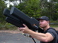
In the spring of 2017, the U.S. Marine Corps Warfighting Laboratory (MCWL) — via the Defense Department’s Defense Innovation Unit Experimental (DIUx) — engaged in a one-year prototype contract with Sensofusion to develop a ground-based mobile counter-UAS solution stemming from Sensofusion’s pre-existing core product Airfence.
Sensofusion acted as lead integrator and further advanced Airfence to integrate radar and optics systems on board vehicles enabling all systems to work in unison, with Airfence being the core counter-UAS solution by means of RF detection and transmission.
The DIUx project has been active for more than 12 months, growing and expanding since its late March 2017 launch.
Airfence is now fully ruggedized, meeting IP67 ruggedization requirements. Furthermore, Airfence has outperformed all tests for range of detection and counterattack capabilities and has also greatly increased the number of drones within its library it can detect, track and defeat yielding zero false positives, Sensofusion said. The system has outperformed range testing at the Marine Corps Base in Quantico, Virginia.
In addition, Airfence exceeded expectations against a large variety of small UAVs — including fixed wings and rotorcrafts — while Marines operated the technology under extreme weather conditions in Arizona at Yuma Proving Grounds. YPG is the largest U.S. military installation in the world and has been a key site for testing military equipment since World War II.
Through its work with the U.S. Marine Corps, Sensofusion has brought its system to a single sensor solution, which is beneficial for tactical use in a mobile convoy scenario.
Airfence also can be used for fixed installations when protecting areas such as military bases, airports, prisons, oil refineries and pipelines, nuclear power plants, power plants, government buildings and border walls.
Sensofusion has made major leaps in its ability to detect and defeat rogue drones by means of protocol demodulation and manipulation.
“Our work in the past year with the Marines enables us to meet production readiness with our flagship counter-UAS solution, AIRFENCE, and are now prepping for production with the Departments of Defense and Homeland Security,” said Sensofusion Vice President Kaveh Mahdavi. “We’re now at a point where DoD, DHS — really, any government organization — can order our standardized counter-UAS platform, Airfence, in large quantities. This is a significant advancement within our developing drone defense industry and will act as the benchmark for all future solutions.”
Extension to Sensofusion-U.S. DoD contract signed. As Sensofusion ramps up production for AIRFENCE across government agencies in America, it continues to align with MCWL, signing a one-year extension to the agreement with the DoD to innovate and implement new capabilities within signal intelligence.
Topcon Positioning Group’s Dave Henderson explains how Topcon’s products are integrated in Intel’s Sirius Pro fixed-wing UAV and Falcon 8+ drone at Xponential 2018 in Denver. Henderson also gives an overview of the new Topcon payloads that will be available for the Falcon 8+.
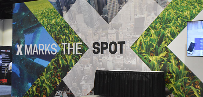
The event convenes the global community of commercial and defense leaders in intelligent robotics, drones and unmanned systems. Check out news, photos and videos from the show.
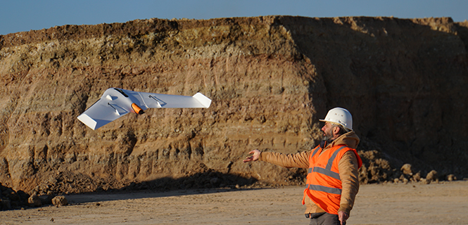
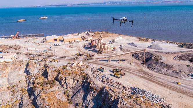
The UX11 is a lightweight, beyond-visual-line-of-sight (BVLOS)-ready fixed-wing mapping drone.
The combination of on-board processing capabilities, real-time control and centimeter-level precision make it a cost-effective solution for large area surveying and mapping, Delair said.
The Delair Septentrio UX11 mapping UAV. (Image: Septentrio)
By employing the latest high-specification photographic, sensor and communications elements, Delair has kept the weight of the UX11 — including payload — down to 1.4 kilograms (3.1 pounds). Among other design innovations, this allows the UX11 to cover 200 hectares (500 acres) in a single one-hour flight, delivering mapping with ground sample distances below 1 centimeter per pixel (0.4 in/px) with accuracy down to 1.27 cm (0.5 in).
A 3G/4G network link to the UX11 allows the operator to assess in real time the quality and overlap of images during flight and make any necessary adjustments to the settings of the integrated camera. This enables operators to collect as much aerial intelligence as possible in a minimum number of flights.
The UAV also features BTOL (bird-like take-off and landing) for steep-climb take offs and descents in confined areas.
The AsteRx-m2 delivers high-precision multi-frequency quad-constellation GNSS measurements for PPK (post-processed kinematic) for only 28 grams, and consumes very little power.
The combination of high-quality camera images and GNSS measurements from the AsteRx-m2 allows Delair to offer its users PPK survey-grade ground precision down to 1 centimeter. With Delair’s PPK software, powered by Septentrio’s GeoTagZ PPK library, users only pay for the precision they need and on a flexible pay-as-you-go basis.
“With the AsteRx-m2, we can offer wide-area coverage at ultra-high precision,” said Chase Fly, geospatial product manager at Delair. “The Delair UX11 sets a new standard of efficiency, cost and quality in a long-range UAV platform. The drone itself is truly state-of-the-art in its design and construction, and it enables industry-leading performance and flight range, as well as streamlined maintenance, advantages that all reduce costs.
“The integrated processing capabilities are able to ensure image quality in real time and provide users with accurate results that shape critical operational decisions and strategies,” Fly said. “And it’s designed for flexible use in a variety of conditions and use models, further lowering TCO.”
The AsteRx-m2 features Septentrio’s proprietary GNSS+ suite of positioning algorithms to convert difficult environments into good positioning:
LOCK+ technology to maintain tracking during the heavy dynamic vibration typical of UAV flights
APME+ to combat multipath
IONO+ technology to ensure position accuracy during periods of elevated ionospheric activity.
The AsteRx-m2 also features AIM+ interference mitigation and monitoring system that can suppress the widest variety of interferers, from simple continuous narrowband signals to the most complex wideband and pulsed jammers.
AIM+ can diagnose self-interference from other electrical or electronic devices onboard the UAV as well as mitigating external interference during operational flights.
“Driven by the explosion in the number and variety of drone applications, drone technology has advanced leaps and bounds in recent years and Delair have been right at the heart of the action. With their focus on innovation and a commitment to providing the very highest quality products, Delair and Septentrio are true kindred spirits and we’re proud to be part of the UX11 project,” said Gustavo Lopez, product manager at Septentrio.
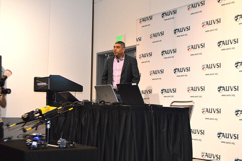
Intel’s Anil Naduri discussed some of the company’s updates at Xponential 2018. Photos by Allison Barwacz
Intel shared a number of updates at a presentation during AUVSI’s Xponential 2018, which took place April 30-May 3 in Denver. Among the company’s latest developments are its Insight Platform, Mission Control and Falcon 8+.
Intel Insight Platform
Intel’s Insight Platform is a digital asset management system that enables aerial data management and analysis. It allows customers to store, share and manage data that commercial drone systems collect. According to the company, the platform is designed to reduce costs, improve efficiency and fuel growth.
The Intel Insight platform takes the aerial data and can generate 2D and 3D models, take measurements and run data analytics.
“The asset-based approach allows you to tag repeated flights over the same location, and that provides a great foundation for you,” said Anil Nanduri, vice president and general manager of the Intel drone team.
Intel Mission Control
Intel’s Mission Control is the company’s next-generation flight planning software for its Falcon 8+ drone. According to the company, it is designed to increase workflow efficiency and enhance automation of drone flights for commercial missions.
Mission Control allows Falcon 8+ drone operators to create 2D and 3D flight plans for commercial surveying, mapping and inspection missions.
Intel Mission Control software is currently in beta testing with customers, Intel said.
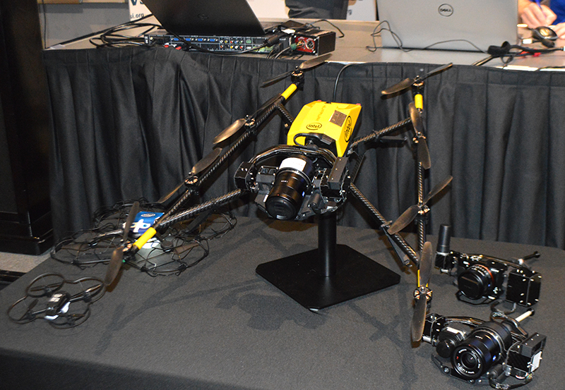
Falcon 8+ drone
Intel revealed three new payloads for its Falcon 8+ at Xponential. Photo by Ryan Gerard
During the presentation, Intel revealed three new payloads, as well as distance hold and distance guard features, for its Falcon 8+ drone.
The three new payloads are designed for inspection, surveying and mapping applications. According to Intel, the Falcon 8+ also now boasts distance hold and distance guard features on the Intel Imaging and Duel Imaging payloads. The distance hold feature allows the drone to maintain and hold a set distance from certain obstacles during inspections, and distance guard is another obstacle avoidance feature.
The company also shared how the drone has assisted with natural disasters and safety inspections. The Falcon 8+ played a role in disaster relief for the Sonoma County fires, as well as data recovery following Hurricane Harvey in Houston.
The drone also assisted with a gas terminal inspection in Scotland, as well as with Arctic wildlife research.
“Drones are going to be the most transformative business technology in the coming generation,” Nanduri said.
According to Phase One Industrial, the iXM 100MP is a high-productivity metric camera with a range of high-resolution lenses. Photo by Allison Barwacz
Phase One Industrial has launched the iXM series, an aerial camera platform driven by its fast medium-format imaging sensor.
Engineered for UAV-imaging missions, the iXM 100MP is a high-productivity metric camera with a range of high-resolution lenses. It is ready for integration with various UAV platforms, including Phase One’s DJI Matrice 600 Pro solution.
The iXM 100MP metric camera incorporates the first medium-format sensor with backside-illumination technology, enabling high light sensitivity and extended dynamic range. Fast, highly responsive, robust and weatherproof (IP53 compliant), the iXM 100MP delivers superior quality aerial imaging and flexible operation to satisfy diverse mapping, surveying and inspection applications, the company said.
In addition, Phase One announced four new specially developed RSM lenses — with focal lengths ranging from 35mm to 150mm — to seamlessly fit the new sensor’s 3.76 μm pixel size and 33 x 44 mm frame size, ensuring image sharpness across the entire FOV. The lenses are available with either fixed-focus or motorized-focus functionality.
The fixed-focus 35mm and 80mm lenses provide superior image radiometric quality, high ground resolution and large coverage, suitable for surveying applications.
The motorized-focus 80mm and 150mm lenses are designed for a wide range of inspection applications, including electricity poles, wind turbines, bridges, and other private-sector or government structures.
Motorized-focused lenses, having no external moving parts, enable a number of new uses for inspection applications where the focusing distance can be predefined based on flight planning, or by the operator, using a wireless remote control. With the motorized lens, the camera captures sharp and highly detailed images of multi-distance or 3D objects.
The cameras’ RSM lenses incorporate a new leaf-shutter technology, which supports 3 fps capture — with a speed of 1/2500 sec — while guaranteeing 500,000 actuations. The lenses are thermally stable to ensure consistent focus over a wide range of temperatures and flight altitudes.
With optics designed to exploit the full benefits of the new sensor technology, the lenses provide with greater productivity, flexibility and reliability, offering superb image quality.
The new iXM platform adds XQD high-speed storage technology to handle the sensor’s extremely fast frame rate. Also on all cameras, HDMI output from actual exposure provides UAV operators simple and outage-free feedback of actual view, exposures, and camera status in overlays.
In addition, the new platform includes USB-C and 10G Ethernet for versatility of connectivity to large UAVs and aircraft.
“Working with our UAV partners, we see a fast-growing market driven by great potential for time and cost savings over traditional inspection and surveying methods,” said Dov Kalinski, General Manager of Phase One Industrial. “With its new technology, design, and capabilities, the iXM 100MP promises to help start a new era in inspection missions with UAVs. Phase One Industrial continues to push technical boundaries to equip drones and larger UAVs with superior imaging technology — engineering advanced systems, cameras, and software — to help achieve that potential.”
The iXM 100MP and iXM 50MP metric cameras are available for advance order from Phase One Industrial partners worldwide with delivery in June 2018.
As the days tick down towards the coming AUVSI Xponential convention in Denver April 30 to May 3, new UAV/UAS developments and applications continue to appear, indicating that this industry could be moving from startup into the beginning of a growth phase.
Skycatch and DJI high-precision drones for Komatsu
The construction industry has always been one of the preeminent areas that require medium- to high-precision surveys. And Komatsu has become one of the world’s leaders in machine automation for the construction site.
Now Komatsu has committed to the automation of site surveys using drones, which ultimately appears to be packaged as a turnkey service for construction companies.
Komatsu aims to show up at a site with all the necessary automated construction machinery and a small staff of automation experts. The experts will survey the site using Skycatch drones and manage the construction for the contractor.
Skycatch drones will survey construction sites with existing RTK networks. (Photo: Skycatch)
Skycatch, based in San Francisco, California, has teamed with Komatsu, who has apparently invested financially in the company and purchased around 1,000 Explore1 drones manufactured by DJI from Skycatch.
Explore1 is actually a modified Matrice 100 DJI drone with special additions. A Skycatch onboard computer links GPS real-time kinematic (RTK) high-precision positioning with a gimbal-mounted 20-megapixel high-resolution camera and the flight computer, resulting in centimeter-level geocoded data.
The big deal is that the system uses existing RTK networks.
Komatsu has been using Skycatch systems for more than three years. The Explore1 system is a combination of all the lessons learned on ease of use and time to collect usable data. Explore1 is used to digitize construction sites during planning, construction and completion.
NASCAR drone protection
It’s unfortunate, but nowadays there always seems to be heightened awareness that events where lots of people gather may present ideal opportunities for possible terrorist attacks. And there has been much made of the possibility that UAVs may be included in the next wave of offensive means for terrorists to inflict civilian casualties on the Western world.
So it’s comforting to hear that for the recent NASCAR race in Fort Worth, Texas, a number of security organizations decided to take the precaution of installing drone countermeasures for the event.
DroneGun, part of the DroneShield anti-UAV system. (Photo: DroneShield)
At the Fort Worth race, the Texas State Department of Public Safety, the Denton County Sheriff, the Fort Worth Police Department, the Texas Forest Service and the Texas Rangers used DroneShield anti-drone systems for the protection of the 2018 Monster Energy NASCAR Cup Series at the Texas Motor Speedway on April 8.
DroneSentinel for drone detection, DroneSentry used for integrated detection and defeat, and DroneGun drone interception were all deployed to determine where drones may be operating and to intercept them if required.
This appears to have been the first known live operational use of all three products by U.S. law enforcement to provide “peace of mind in the aerial domain,” as expressed by an officer about the event.
No bees? Just call for a drone
I’m always frustrated by the fruit tree in my backyard — it absolutely insists on flowering in March when there seems to be more high winds than at any other time of the year, so most of its blossoms are blown to the ground. It’s a mature tree, and you would imagine that it should have learned by now.
But when it is calm and warm, only a few butterflies and birds seem to show any interest. I hardly ever see any bees buzzing around and doing their pollinating thing, and so fruit is hard to come by later in the year.
I’ve thought of borrowing my wife’s make-up brush and dabbing my way round the flowers, but the neighbors, or my wife for that matter, might see me and call the cops to get me taken away…
So I was quite interested when I saw that an outfit called DropCopter, based in Corning, California, is setting about pollination using customized drones. DropCopter basically supplements lost bees by flying over flowering fruit trees and dropping pollen on their blossoms using a drone.
This UAS start-up has initiated a drone pollination service which uses automated multi-rotor drones to dust almonds, pistachios and cherries, boosting crops by up to 15 percent! It seems that fruit producers can rent bees when it comes to pollination time, but bee-rental costs have apparently soared recently. Growers may have been paying up to $180 for one hive to be relocated among their fruit trees. These costs have been cutting into margins and raising the price of fruit at the store.
Enter DropCopter to alleviate pollination problems and restore profit margins for the growers.
DropCopter is using some funding provided by GENIUS NY sponsorship to operate its patent-pending pollination system during nighttime over local New York orchards. Bees don’t like the colder night temperatures, so DropCopter can double the pollination time by operating at night while the bees work the day shift.
But where the heck does DropCopter find all the pollen necessary to fill its pollen distribution containers on its drones? The mystery of fruit pollination still puzzles me.
Range of novel UAV applications grows
So, it’s quite a range of interesting drone applications: automated site survey using drones and a suite of Skycatch processing and data-delivery software; anti-drone protection systems becoming commonplace at larger events; and nature getting a helping hand from pollinating drone systems… Who would have ever thought we’d be seeing these novel, innovative drone solutions?
But, then again, who would have ever expected in the pre-2000 timeframe all the applications that GNSS alone has managed to open up?
According to AUVSI, the experts will present keynotes devoted to themes critical to the advancement and growth of unmanned systems.
On Tuesday, May 1, the Massachusetts Institute of Technology’s David Autor and PrecisionHawk’s Michael Chasen will highlight how unmanned systems are changing the way we work and how technology is influencing different industries.
On Wednesday, May 2, the University of North Carolina’s Zeynep Tufekci, Lockheed Martin’s Stephanie Hill and UPS’ Eduardo Martinez will explore the cross section between technology and society. This keynote will also cover the emergence of artificial intelligence, unmanned systems and robotics in the military, and the automated delivery of medication and vaccines to remote areas around the globe.
Finally, on Thursday, May 3, Northrop Grumman’s Chris Hernandez, as well as a panel, will discuss the humanitarian and public safety applications of unmanned systems to provide aid and support.
The panel will consist of the National Council on Public Safety UAS’ Charles L. Werner, Texas A&M University’s Robin Murphy, the Alameda County (California) Sheriff’s Office’s Thomas Madigan and the Colorado Division of Fire Prevention and Control’s Mike Morgan.
“We are pleased to welcome this exceptional line-up of experts to keynote the themed sessions at Xponential 2018,” said Brian Wynne, AUVSI president and CEO. “These outstanding speakers will enhance Xponential’s educational programming by lending their expertise, experience and unique perspective in unmanned systems, giving attendees a priceless opportunity to apply critical learning to real-life business challenges.”
Wingtra has officially launched the WingtraOne PPK high-precision mapping drone. Wingtra said its drone, which features vertical take-off and landing, is designed to set a new benchmark for large-scale surveying and mapping applications.
WingtraOne PPK offers large area coverage, ultra-high accuracy and brilliant image resolution. It features an advanced PPK module and high-quality cameras like the 42-megapixel full-frame camera Sony RX1RII, it is now possible to reach down to 1-centimeter absolute accuracy in aerial mapping.
To prove this accuracy claim, the Wingtra team performed test flights in a gravel quarry. The process was documented and is now explained in a white paper on the company website.
Conventional drone mapping on centimeter accuracy requires ground control points (GCPs) to correct the final map. Besides requiring additional surveying equipment and being extremely time consuming, setting up GCPs might be downright risky or just not possible in the area of interest.
More advanced solutions achieve similar levels of accuracy by using GPS correction technology for the georeferencing of the aerial imagery: namely RTK (real-time kinematics) or PPK (post processed kinematics).
RTK requires real-time base station connectivity and corrects GPS signals during the flight, while PPK corrects them after the flight and therefore offers greater robustness and consistency.
Moreover, PPK is independent from base stations or base station networks. It is highly reliable, accurate and time saving to use, Wingtra said. Neither special flight preparations nor intensive post-processing steps are required to achieve down to 1-cm accurate aerial maps.
Japan-based Aerosense Inc. has commercialized its AEROBO marker solution for drone surveying using the u‑blox NEO‑M8T timing module.
Photo: Aerosense
Conceived to compute absolute time to within 20 nanoseconds using incoming GNSS signals, the NEO-M8T lets users access raw GNSS data output, making it attractive for positioning applications that rely on post-processing GNSS data to enhance location accuracy.
Aerosense’s surveying solution is designed to reduce the time spent surveying construction sites. By combining ground markers equipped with a GNSS receiver with surveying drones and cloud-based data processing, Aerosense has converted huge workloads into a user-friendly application.
The surveying operation on the site involves setting up ground markers fitted with u‑blox NEO‑M8T high-performance GNSS receivers. The smart ground markers send the GNSS data they receive to the cloud, where it is post-processed using a static surveying algorithm to achieve high accuracy.
The AEROBO solution can transform high-resolution drone images into a survey-accurate map by using the absolute geographic coordinates of specific points on the surveyed terrain. Images gathered by overflying the terrain with the drones are combined to create centimeter-precise outputs, including orthomap views, 3D models and point clouds.
The challenge that engineers at Aerosense faced while developing their solution was achieving sufficiently high position accuracy. “We found a robust solution to the accuracy challenge by using the u‑blox NEO‑M8T high-performance positioning module,” said Satoru Shimizu, project leader of AEROBO technology development at Aerosense.
AeroVironment Inc., a maker of unmanned aircraft systems (UAS) for defense and commercial applications, has formed a joint venture to develop solar-powered high-altitude long-endurance (HALE) UAS for commercial operations.
This category of unmanned aerial systems (UAS) is also referred to as high-altitude pseudo-satellites, or HAPS.
The joint venture will fund the development program up to a net maximum value of $65,011,481.
The joint venture, HAPSMobile Inc., is a Japanese corporation that is 95 percent funded and owned by Japan-based telecommunications operator SoftBank Corp. and 5 percent funded and owned by AeroVironment.
The solar-powered Helios in flight.(Photo: NASA)
AeroVironment is committed to contribute $5 million in capital for its 5 percent ownership of the joint venture, and has an option to increase its ownership stake in HAPSMobile up to 19 percent at the same cost basis as its initial 5 percent purchase.
“This is a historic moment for AeroVironment. For many years, we have fully understood the incredible value high-altitude, long-endurance unmanned aircraft platforms could deliver to countless organizations and millions of people around the world through remote sensing and last mile, next generation IoT connectivity,” said Wahid Nawabi, AeroVironment chief executive officer.“We were searching for the right strategic partner to pursue this very large global opportunity with us.Now we believe we are extremely well-positioned to build on the decades of successful development we have performed to translate our solar UAS innovations into long-term value through HAPSMobile Inc. Our entire team is excited, and we look forward to transforming this strategic growth opportunity into reality.”
AeroVironment pioneered the concept of high-altitude solar-powered UAS in the 1980s, and developed and demonstrated multiple systems for NASA’s Environmental Research Aircraft and Sensor Technology, or ERAST program, in the late 1990s and early 2000s.
In August 2001, the AeroVironment Helios prototype reached an altitude of 96,863 feet, setting the world-record for sustained horizontal flight by a winged aircraft.
In 2002, the AeroVironment Pathfinder Plus prototype performed the world’s first UAS telecommunications demonstrations at 65,000 feet by providing high-definition television (HDTV) signals, third-generation (3G) mobile voice, video and data and high-speed internet connectivity.
Multiple U.S. government agencies funded the development of the hybrid-electric Global Observer unmanned aircraft system from 2007 through 2011. Global Observer represents a solution for extended operation over high northern and southern latitudes during local winters, when the sun’s energy is insufficient to maintain continuous solar aircraft operation at high altitude.
SoftBank Corp. and AeroVironment, Inc. have agreed to license certain background intellectual properties to HAPSMobile, which will own the newly developed UAS intellectual property and possess exclusive rights for commercial applications globally, and non-commercial applications in Japan.AeroVironment will possess exclusive rights to the resulting intellectual property for certain non-commercial applications, except in Japan.AeroVironment will also possess exclusive rights to design and manufacture all such aircraft in the future for HAPSMobile, subject to the terms of the Joint Venture Agreement.
For additional information, please see AeroVironment’s Form 8-K, filed with the Securities and Exchange Commission on Jan. 3.
SkyX Systems Corporation has successfully completed an unmanned data-collection flight of 100 kilometers (km), one of the longest journeys in its class.
The firm flew its SkyOne unmanned aerial system (UAS) on an autonomous data mission over more than 100 km of gas pipeline in Mexico. The robotic flight was programmed and monitored remotely from the company’s Greater Toronto Area SkyCenter mission control, with a support crew of engineers on the ground in Mexico.
Using high-resolution imagery, the longest of multiple flights identified more than 200 potentially significant anomalies along the remote pipeline, ranging from unauthorized buildings and cultivation, to a fissure possibly caused by seismic activity.
More than $38 billion is spent annually monitoring oil and gas pipelines using less efficient means. The SkyX System flight gathered data in a little more than an hour that would have taken a person well over a week. It identified more than 200 georeferenced anomalies the customer was unaware existed, pinpointing precise coordinates for rapid investigation and remediation.
The SkyX System consists of a vertical takeoff and landing (VTOL) drone, the SkyCenter control room, which allows for real-time and secure mission monitoring from remote locations, as well as the company’s proprietary SkyBoxes that enable SkyOne to recharge and continue long-range missions without having to return to home, a factor that limits many drones.
Using the system, a client doesn’t need a trained pilot to operate a remote-control unit — the entire mission is programmed and carried out autonomously, from takeoff to landing. Plus, the VTOL drone eliminates the need for runways, launchers or capture devices.

 Airfence also can be used for fixed installations when protecting areas such as military bases, airports, prisons, oil refineries and pipelines, nuclear power plants, power plants, government buildings and border walls.