DJI has unveiled its Mavic 2 Enterprise, a portable drone designed to improve everyday work for businesses, governments, educators and other professionals.
According to the company, the Mavic 2 Enterprise features an ultra-compact and foldable design with an array of advanced controls and accessories that extend users’ capabilities during critical operations like firefighting, emergency response, law enforcement and infrastructure inspections.
The drone carries a high-resolution, 12-megapixel camera that’s stabilized by a three-axis gimbal for smooth and stable videos and images. The camera also features a two-time optical and three-time digital zoom capability, the company said.
The Mavic 2 Enterprise can be used for inspections and other everyday tasks. (Photos: DJI)
The Mavic 2 Enterprise comes equipped with a number of accessories, including the M2E Spotlight, M2E Speaker and M2E Beacon. The M2E Spotlight, which has a brightness of 2,400 lumens, is ideal for search-and-rescue operations, as well as inspection applications, the company said. The M2E Speaker allows pilots to play up to 10 custom voice recordings on demand. Finally, the M2E Beacon features a bright flashing strobe that’s visible up to three miles away, DJI added.
According to DJI, the drone also includes a GPS timestamping feature that encodes the time, date, and location of every recorded image, aiding in pilot accountability and ensuring that data captured by the drone can be trusted and used in situations from reviewing critical infrastructure inspections to potential legal proceedings.
It also comes equipped with DJI’s AirSense technology to help improve pilots’ situational awareness and enhance airspace safety. According to DJI, AirSense uses an integrated receiver to automatically alert drone pilots of ADS-B signals from nearby airplanes and helicopters, providing real-time positioning alerts through the DJI Pilot mobile app.
Finally, the Mavic 2 Enterprise features DJI’s latest video and data transmission system, Ocusync 2.0, which helps provide a more stable connection between the drone and its remote controller.
“With the Mavic 2 Enterprise, DJI has created a drone that makes powerful technology accessible to every enterprise and revolutionizes how they do their work,” said DJI President Roger Luo. “DJI’s hardware and software set the standard for aerial innovation around the globe, and Mavic 2 Enterprise is the most compact, powerful, reliable and safe tool to help professionals integrate drones into their operations.”
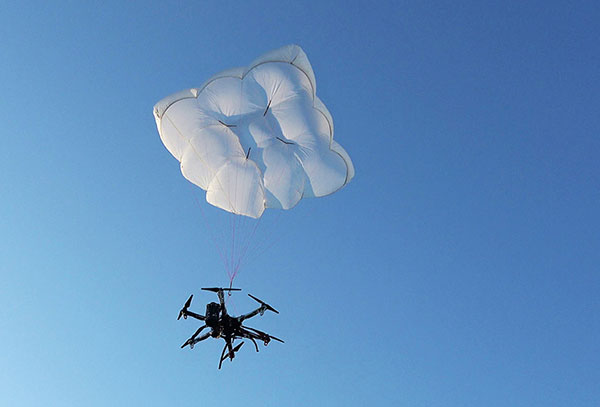
Drone Rescue will present its parachute systems DRS-5 and DRS-10 to the professional public for the first time at Intergeo, at stand 12.0B.112 in Hall 12, Oct. 16-18.
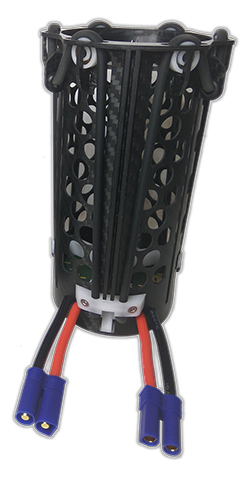
Parachute rescue system DRS-5 is designed for multicopters with a total weight of up to 8 kg. The system consists of a carbon cage in which the parachute is stored, as well as the associated electronics.
The electronics, including the sensors, monitor the flight status of a drone independent of the flight controller. A sophisticated algorithm merges this sensor data, through which an automatic crash detection can be realized, the company said. In an emergency, the pilot no longer needs to react and press an eject button. (Often, this is technically no longer possible anyway, such as with a failure of the radio link.)
Furthermore, the algorithm reacts faster than the pilot: the system ejects the parachute itself. All flight data and movements are recorded in a black box. In an emergency, these can be read out at the request of the customer and made available to insurance companies or authorities.
“Our goal is to ensure that even in an emergency beyond visual line of sight the drone can be safely intercepted. With our parachute system, that is always possible, due to the electronics that are completely separate and independent of the flight controller,” said Andreas Ploier, CEO and co-founder of Drone Rescue. “In addition, our system has the advantage that it manages completely without explosive, pyrotechnical solutions. Consequently we have a system that is considerably lighter, and functions even in a worst-case scenario.”
DRS10 system. (Photo: Drone Rescue)
The reliability of the system has been verified in extensive tests by Joanneum Aeronautics in Graz, Austria. In the framework of the tests, 100 flights were conducted during which the parachute system was ejected.
Half of the flights were conducted with a DJI F550 weighing 1.6 kg. The rest of the tests were performed with the 3.8 kg Vulture, which was developed by the FH Joanneum.
In both cases, the DRS-5 was attached to the side of the main body of the drone. In each of the tests the parachute was ejected at a height of 30 meters. Every test was documented.
Furthermore, the data were saved both in the flight controller as well as in the DRS-5 sensor system. After every 10th test, the parachute system was subjected to a visual examination and checked for possible damage or wear.
“After conclusion of the tests, it can be recorded that all 100 flights were successfully completed,” Ploier said. “In every test the multicopter landed safely. Thereby, the kinetic energy was significantly below the limit of 79 J. All requirements specified by the European Aviation Safety Agency (EASA) were observed.”
Besides the DRS-5, the structurally identical parachute system DRS-10, which is designed for multicopters with a total weight between 5 and 20 kg, will also be presented at Intergeo 2018. “The DRS-10 system functions exactly the same as the DRS-5 and falls back on the same components. These are constructed identically, just oriented for a higher payload. The functioning method of both parachute systems is identical,” Ploier said.
With flight tests for the DRS-5 completed in late summer, the first systems will be delivered to end customers in winter 2018.
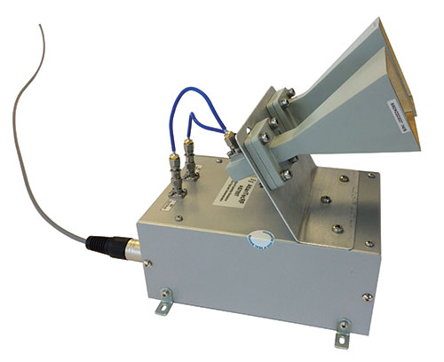
Atlantic Microwave, a U.K.-based satellite communications company, has announced the maiden flight of its DSS Satellite Simulator product on board an eight-rotor drone.
Off-air testing of ground- and vehicle-based satellite communications systems has developed into a major industry need with the current explosion of satcom applications in multiple industries, Atlantic Microwave said.
Atlantic’s satellite simulator and loop-test translators were aboard the drone in a first flight in Denmark, using frequencies in the Ku band for proof of concept. Atlantic is also offering similar payloads in Ka band (which delivers greater bandwidth), X band for the military, as well as future Q and V band operations.
“We are in an exciting age where new technologies are shaping our current and future lifestyles,” said Atlantic’s CEO, Geoff Burling.”At Atlantic Microwave, we embrace these advances and seek, innovatively, to create solutions in all kinds of communications industries.”
Atlantic Microwave, based in Braintree, U.K., provides satellite simulation with antenna and cabled-in based products, which have been supplied to major satcom operators, integrators and manufacturers on all continents.
As Hurricane Florence rattles along the coastlines of the Carolinas and Georgia creating havoc, everything that flies is grounded. Right now the hurricane has slowed to a tropical storm, but flooding is extensive and people have died.
As soon as the high winds subside, expect almost all first response groups to put up UAVs to begin damage assessment. Digital images gathered by these drones will assist forward personnel to direct recovery and rescue operations. FEMA and other search and rescue teams, already in place along the track of the storm, have begun to rescue people by boat and are expected to fly drones over other inaccessible areas to find survivors.
And, of course, a significant part of the coverage we will see over the next week or so will come from drone-borne TV cameras and links to network uplink vans. We should also expect drones to be used for significant data gathering to map affected areas for damage to homes and infrastructure — including powerlines, radio and cellphone towers and distribution centers, waterways, roads and railways.
Let’s hope that the lessons learned and experience gathered during the major storms of last year will help everyone operating drones assist in minimizing the time to rescue people and to speed recovery from this latest hurricane. Later, expect the insurance companies to arrive with UAVs to assess damage and verify claims.
Police forces are using drones…
The law enforcement office in Dauphin County, Pennsylvania, has been using a drone for several months. With more than 13 investigations completed, the drone has helped locate one lost individual and has also supported crime-fighting.
Rather than calling out a manned helicopter for assistance, the police are able to get a drone in the air within 20 minutes at much less cost.
FAA regulations govern how Dauphin County law enforcement officials fly their drone, including a waiver granted to allow night-time operations.
…while Colombia is testing drones to destroy coca plants.
Recent growth in Colombian coca cultivation to 516,000 acres during 2012-2017 came as a consequence of the end of a government program to fumigate coca fields. Crop-duster planes spraying glyphosate had previously reduced Colombia’s coca fields from 470,000 to 193,000 acres during 2001-2012, according to U.S. figures.
Meanwhile, U.S overdose deaths from cocaine are continuing to increase, while rebels and drug traffickers have apparently shot down several crop-dusters.
Lawsuits against the use of the chemical glyphosate have also been successful. Over-spray is alleged to have killed other, legal crops, and opponents also cited a recent ruling in California that awarded $289 million in damages to a groundskeeper who said glyphosate-based weed killers had caused his non-Hodgkin lymphoma.
Because of concerns, Columbian police have been testing drones — flying a couple of feet above the plants to mitigate over-spraying of defoliants — to kill coca crops and reduce the supply of cocaine. Apparently, 10 remotely guided drones, each weighing 50 pounds fully loaded, destroyed hundreds of acres of coca in the first phase of tests. Though common in agriculture for the monitoring of crop growth, it’s thought that drones have never before been used to kill illegal crops. The fumigation appears to be about 90% effective to date.
Nevertheless, in Colombia’s drug zones, soldiers will be needed to partition swaths of coca-producing land and to defend operators from angry farmers and drug traffickers. There are also land mines which will need to be overcome from Colombia’s long rebel conflict and which pose a danger to drone operators.
Counter UAS (C-UAS) systems are on the rise.
The Drone Dome system uses Laser, RF and Radar. (Photo: Rafael)
As fast as drone technology is developing, counter UAS (C-UAS) systems are also being put in place to prevent unwanted drones from penetrating the air above sensitive facilities — by detecting and disabling them. There are purportedly more than 60 such C-UAS systems available in the U.S., with more in other countries including China and Russia.
Systems use various technologies for detection — such as radar, laser, optical/IR, RF “sniffer,” and acoustic. Drones can be disabled by RF and GNSS jammers, by spoofing of both the GNSS navigation or the control link, and can be brought down physically by high-power lasers, nets deployed by other drones, collisions by attack drones, by regular or specialized anti-drone gun systems and even by high-pressure water cannons for very close-in defense. Anti-drone systems include detection and take-down dome-based systems and man-portable drone guns.
SpotterRF C-UAV radar. (Photo: UAS Vision)
The UK government has acquired the Drone Dome C-UAS (counter-UAS), manufactured by Rafael, Israel. Detection is provided by an S-band radar (four radars provide all-round coverage), an electro-optical/infrared (EO/IR) surveillance suite, and a wideband RF sensor.
Drones can be disabled by a high-power laser, an RF jammer, or when very close-in by a high-pressure water gun. The UK system is expected to use jamming to bring down drones and doesn’t include the high power “hard-kill” laser option.
Depending on the size of the intruder drone, the radar detection range is around 3.5-10 kilometers, and the radar may also disable a UAV when integrated with the RF jammer. With an active electronically scanned array antenna, the radar is relatively small and light-weight for both fixed and mobile installations.
The DroneGun. (Photo: DroneShield)
Another C-UAV offering, from SpotterRF, claims to solve the problem of requiring multiple radar elements to achieve 360-degree “dome” coverage. The 3D-500 radar enables full “dome-drone” detection from 0 to 90 degrees vertical and 360 degrees horizontal using a single radar with a 500-meter detection radius, yet weighs only 12 pounds.
Latitude, longitude and altitude of intruder targets are measured within a 1-kilometer diameter hemisphere dome. Following radar detection of an unauthorized drone, the system may be augmented by a slew-to-cue optical/IR camera providing a visual display to an operator — a directional RF jammer on a pan/tilt turret can then be activated to take-down the intruder. The system operates automatically to both detect and disable the drone, or manual control is possible to enable initial operator confirmation of the target before take-down is activated.
DroneShield out of Australia markets a drone detection and mitigation system probably best known for its DroneGun. The DroneGun is a point and shoot device able to disrupt multiple RF frequency bands simultaneously (433 MHz, 915 MHz, 2.4 GHz and 5.8 GHz), taking out the communication link to a drone operator — and also GNSS signals when so equipped — up to 1 kilometer away.
The full DroneSentry detection system integrates a suite of sensors and countermeasures including radar, optical, RF listening, acoustic, thermal and an RF countermeasure transmitter with greater power and range than the portable DroneGun.
Another example is the Rex-1 drone gun. Operating in the 2.4 GHz and 5.8 GHz bands, the Rex-1 rifle-like drone-disabling device is a man-portable jammer developed by Russian Kalashnikov Group subsidiary ZALA Aero Group.
https://youtu.be/Px56KtpZ004
Mapping and survey are becoming a major application for drones.
One such example is 3D mapping of a copper mine in only three days using a fixed-wing UAS.
At an altitude of 1,400 meters, the Erdenet open-pit mine in Mongolia extends 5 x 2 kilometers and is more than 200 meters deep in places. Despite strong winds and even some snow in May this year, one UAS quickly captured geospatial data that enabled three-dimensional modeling of the large, complex site.
Site management is expected to use this initial model as a baseline against which future drone-maps will be compared, and to plan future mine operations.
However, extensive preparations over a two-week period were still required, including the installation of 21 ground control points, positioned using GPS RTK measurements. Re-verification of these points was also required from time to time before the survey, due to changes in the mine from ongoing mine operations, including dynamite blasting.
A MAVinci Sirius UAV was used to gather almost 7,000 aerial photographs which were processed through Agrisoft Photoscan Pro software to produce a detailed digital surface model. All the data collected will be used to create various internal views of the mine for continued mining operations. The mine produces about 26 million tons of ore each year, leading to approximately 530,000 tons of copper and 4,500 tons of molybdenum derivatives.
UAVs make medical deliveries.
Some U.S. medical facilities will soon be participating in a Department of Transportation test program to transport medical samples and supplies by UAV — the object being to obtain test results and medical supplies much quicker than at present. Matternet, Zipline and Flytrex — UAV companies already involved in deliveries by drone — will use several different UAVs in the program, which also aims to set up a number of medical distribution centers.
Matternet has been delivering medical supplies by drone in Switzerland, and Flytrex is focusing on food and package deliveries.
Delivery drone in Kasungu, Malawi. (Photo: AFP)
Meanwhile, Zipline and UNICEF have established an “air corridor” in the city of Kasungu in Malawi to test the transport of medical supplies by drone. Rwanda had previously used UAVs to deliver medication in Africa. Other underdeveloped countries without good ground infrastructure could well benefit by using life-saving drone deliveries for urgently needed medication.
Supporting police investigations, mapping of mines, and coca crop destruction all seem to be good examples of newer uses for unmanned air vehicles. And when policing of drone intrusion is required, looks like there are many new options to detect, disable and even take down unwanted drones. I’d say we seem to be making good progress towards better acceptance and that the industry is starting to grow up.
And let’s all hope that the efforts of all first responders in the Carolinas and Georgia continue through the many weeks of recovery from flooding and damage that are still to come, and that people can soon get back into their homes.
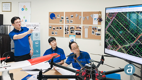
SimActive Inc., a developer of photogrammetry software, has enabled the first government drone mapping project in South Korea.
Asia Aero Survey (AAS), a SimActive regional partner, used Correlator3D for the public survey delivered to the Korean National Geographic Information Institute (NGII) and the Korean Association of Spatial Information, Surveying & Mapping.
While such projects were previously conducted using manned aircraft, a drone was preferred because of the difficulty in accessing the area of interest through traditional aerial and ground surveying methods.
The NGII officially published guidelines for public surveying and mapping with drones in March 2018, with the AAS project being the first delivered and accepted as adhering to the new guidelines.
AAS is also deploying UAV solutions with hyperspectral and lidar for other projects in conjunction with SimActive software.
Spry Drone briefly submerges under water to flip on its belly then fly in the air like a bird (PRNewsfoto/Urban Drones)
SwellPro USA and Urban Drones have released a waterproof drone, the Spry, that can briefly submerge like a submarine, float like a boat and fly in the air at over 43 mph.
The Spry features a self-contained camera that can capture video at 30 frames per second and pictures at 12 megapixels. According to the company, the Spry gives users the ability to capture high-resolution video and pictures without compromising speed and agility. It can also wirelessly transmit the video signals to a monitor embedded in its waterproof remote control.
The Spry’s GPS can be activated from the remote control, which has an integrated 4.3-inch monitor to view the Spry’s live video feed. It also boasts advanced flight features, such as hold position, auto follow, object orbit and return to pilot’s position.
“The Spry’s ability to submerge under water and fly in the air makes it the most versatile drone ever created,” said Alex Rodriguez, CEO at Urban Drones. “We’ve only seen this in science fiction movies.”
Urban Drones is a drone technology company located in Florida and SwellPro USA’s partner in the Spry project.
June’s Geointelligence Insider article on Jack Maple was the human interest article. One of the readers of June’s article had the opportunity to meet Jack Maple. I appreciate the feedback. This month’s article is based upon the recommendation of Geospatial Solutions Managing Editor Tracy Cozzens to cover the technical side of GIS and crime fighting.
Recap
Fighting crime with GIS sounds simple enough — map where the crimes are happening and where the bad guys are and send in the cops. That would be a gross over simplification. As always, there’s more to the case.
The first CompStat was founded in the pre-internet days of 1994 on a Commodore 64, harkening back to the days of 128-MB floppy disks and MS-DOS, a Jurassic period of computer evolution that marked some of the first steps into crime fighting’s digital era. The graph above is the current CompStat 2.0 from the NYPD. It is a GIS-based system, interactive, user-friendly and available to the public. Take note of the highlighted number.
Since CompStat was introduced, crime has fallen precipitously. As of this writing (Aug. 25, 2018) New York City has 183 reported murders year to date. By comparison, in 1990, prior to CompStat, there were 217 murders per month on average. More murders were committed per month in 1990 in New York City than what it will experience in all of 2018. Murders have dropped nearly 90 percent. In other words, nine out of 10 who would otherwise have been killed are alive to return to their families, parents, classmates and colleagues, and friends. The difference is staggering, providing tangible proof geospatial science is a benefit to humanity.
The arsenal of geospatial applications available for the crime fighter is enough to make any superhero envious. The list of these high-tech, integrated intelligence systems push the limits of science fiction.
The underlying strength of these systems is the robust GIS/GPS platform they are built on. Security cameras are geospatially connected to the network with dynamic mapping capabilities. This allows the surveillance video to be overlaid on GIS software in order to interact with more information and create actionable intelligence.
Cameras use a host of software algorithms that are able to recognize aggressive behavior, patterns, anomalies, change detection, biometric features, objects and text. Systems can integrate real-time information like social media feeds as well as live video, including facial recognition software scans for wanted individuals in real time. This information is shared with police officers in the field.
Police cars are becoming mobile command centers outfitted with a suite of sensors, and will eventually include drones. Police officers wear smart glasses augmenting information about who they are looking at in an intelligence and location-based context.
The police officer’s belt is Bluetooth enabled, connecting all these devices, as well as monitoring the officer’s vital signs. The officer’s gun is also Bluetooth enabled, reporting when it is drawn, the direction it is pointed and if it fired. The gun also comes with a chip for tracking purposes and to ensure only the officer it belongs to can fire the weapon.
The vest-worn camera is woven into the seamless geospatial network of sensors and records the officer’s experience from a first-person perspective.
Imagine this scenario. A crowd gathers at an intersection triggering an anomaly detection sensor due to the number of people gathering in that location at that time. Out of the thousands of security cameras being monitored at the Command and Control Center (C3), this video scrolls around and flashes yellow, bringing attention to the possible situation. Other mounted cameras that have that intersection in the field of view automatically align along the edge of the main security video projecting their imagery onto a 3D data model of the area. Police officers in the field nearest to that location are simultaneously alerted. No action is taken at this point except the police begin heading in that direction. Facial recognition software scans the video images for faces of known suspects. Social media and texts scroll next to the video and geospatially link to those in each frame of the video. Colored sentiment indicators showed levels of concern. Boxes outlining people in various colors correspond to threat levels determined by datamining multiple databases. Semi-persistent motion trails lag behind each box showing the speed and direction of people in the video. Pattern identification looks for convergence, divergence and synchronous movements.
Video analytics identify several people converging on a car that just pulled up. The license plate reader linked to the security camera reports the car as stolen with two traffic violations. Based on this preliminary information, the situation is elevated. A police officer is dispatched but before arriving, a drone launches from the police car outfitted with a true color camera and a stereographic infrared camera. The stereographic imagery pair is streamed live to the police officers entering the area of interest through their smart glasses and to a team of imagery specialists at the C3. The video analytics of the police drone are seamlessly integrated with the security camera videos focusing on the car and the individuals as it arrives on scene and surveils the area. Object recognition identifies three possible weapons on the persons of interest. The boxes around those individuals turn red. They are tagged for persistent surveillance by all security cameras in the area. The order is given to apprehend them for probable cause. More police officers are called in and before they arrive they know who they are looking for, where the person is located, and that they may be armed and dangerous. In less than a minute, the police arrive. The suspects flee. The drone follows one of them up the street into an alley. Two of the officers pursue him. The other two suspects jump into the car and drive away. License plate readers and security cameras track the car on a map showing the vehicle’s route and speed with corresponding real-time video as the vehicle passes into view of each camera. As the vehicle travels south a police officer steps out from a cross street and shoots an electromagnetic dart into the speeding vehicle, disabling it. The police officers approaching the car shine a disorienting laser light weapon called a dazzler at the suspects, preventing their eyes from focusing. The occupants are apprehended without incident. They are searched for probable cause and arrested for carrying handguns without a permit.
The other suspect fled on foot. The drone followed him relaying live imagery to the police officers’ smart glasses. Their smart glasses showed a real-time map of their locations and the suspect’s. They cornered him in a fenced area. Guns drawn, the smoky red light of the laser cutting through the air pointed at the suspect. He surrendered. No gun was found on the suspect but the drone video the gun being thrown into a dumpster. One of the officers went back and retrieved the gun.
Gun traces were run on the three confiscated weapons and one was identified as stolen, matching a description of a gun used in a recent homicide. One of the suspect’s fingerprints match those found on shell casings at a nearby location reported by gunshot acoustic sensors. Based on this information, there is probable cause and a tap and trace is approved electronically by a special task force judge. The phone records of the three suspects are searched linking them to the el Diablo gang. Several unknown numbers are also in the call logs. Those numbers are added to the case file to be investigated later.
Only one of the suspects has a known address. The other two have no known location. Activity extracted from phone records show their whereabouts over the preceding days pin pointing their main locus of operation. Search warrants are issued. Within hours of arresting the suspects, the locations are raided and searched. Officers discover a cache of weapons, drugs, laptops and other useful information.
Everything described above is already available — it is only a matter of time and money. And, if Dubai is any indication of things to come, police could soon be arriving on hoverbikes.
The police arriving within minutes is key to the success of preventive policing. Time saves lives. The goal is to intervene before crime happens. But how is it possible? Before answering, let’s look at some numbers.
By the numbers
In 2017 almost 84 percent of the population of the United States was considered urban residing within 106,400 square miles. The Bureau of Justice Statistics reports there are only 758,854 sworn officers in the United States. Maintaining the same 84 percent ratio as the population means only 634,847 officers cover those urban areas. Specifically, it breaks down to six police officers per square mile. It is one police officer for every 431 residents except that police, like all of us, work 40 hours a week, have days off, take vacations, etc., so, only one out of every six police officers is on duty at any given time. That is one police officer for every 2,153 residents; however, police often operate in pairs, so 4,306 residents depend upon two brave souls to protect them from danger.
Victims of violent crime are 2.1 percent of the population. In a sampling of 4,306 residents that equals 90 victims of violent crime every year. In the top 10 cities it is far worse. Police officers have an incredible responsibility placed on them and they rightly deserve our praise, support and respect for the dangers they face every day.
Why not more officers you ask? Police protection comes at a cost of $100 billion annually. Our relative safety is not cheap. Crime is a huge expense. Jails, trials, public defenders, prosecutors, judges and incarceration all cost money. Safety is expensive. Budgets are stretched thin. The answer for increased safety and security isn’t more police. The answer is integrated and intelligent technology systems leading to increased efficiency. Technology has benefitted most other professions. Now, the field of law enforcement and crime prevention are benefitting. Cost is the driving need. These efficiencies are being realized on a grand scale. Making matters more urgent is the worldwide mass migration as populations move towards cities. It is imperative to manage crime now rather than later.
Enter predictive policing — putting the power of open data, cloud computing, machine learning, geoscience and artificial intelligence in support of law enforcement and prevention. Basically, cities are broken up into grid patterns, typically 500×500 feet. Within each grid, crime data is compiled using multiple factors and resources, such as historical data, 9-1-1 calls, recent crime reports, and residences of known offenders and parolees. Even considerations such as the time, day of week, celebrations and cyclical events are taken into account. Information derived from security cameras, license plate readers, social media and financial transactions help the algorithm. The algorithms take into account information collected by authorized wire taps, call logs and other confidential sources. The goal of the algorithms are to include all available resources to develop the most complete and reliable dataset upon which the heatmaps base their probabilities. This helps police departments allocate their resources, know what to prepare for and, most importantly, know where to be to protect the public at large.
University of Montana, Research and Training Center (Data: U.S. Census Bureau)
Police tighten their patrols around the hotspots. Throughout their shifts those hotspots are subject to change depending upon new data. Mobile units simply focus their patrol efforts accordingly. Once a threat is reported, automated navigation routing systems show police the fastest route to the incident and their expected time of arrival. Officers continue to receive intelligence about the incident while en route to anticipate the situation prior to arriving. Knowing where the areas of highest probability are expected to occur focuses non-human assets too, such as geofencing the areas of interest and monitoring more closely for key indicators. This technology is not too different than numerical weather forecasting models predicting what and where weather events will occur in the next hour, three hours, six hours and so on. Numerical models continue to evolve making forecasting more and more reliable. And, although the past does not predict the future, it is a strong indicator. The disclaimer would be similar to the ones most have seen before, “Past performance does not guarantee future returns.” Sometimes preventing a crime is saving a life, sometimes it’s protecting property and almost always it is stopping someone from doing something they will later regret. All crime cannot be prevented but for every crime that is prevented there is a family spared from tragedy.
Preventive policing does more than help keep communities safer. It improves economic viability. Crime has an inverse relationship with a community’s vibrancy. As crime increases, prosperity decreases. Real estate values go down, the tax revenue goes down, employment opportunities go down, and safety, happiness and well-being go down. Crime is a societal disease. Reducing crime reverses those affects. Home values, employment, affluence and the quality of life all go up, which correlates to increased tax revenues. Thus, reduce crime and the city’s revenues increase. That means politicians can divert money into other programs to benefit the citizens. For these reasons there is bi-partisan support for computer based policing.
If you do the research you will see opposition efforts against artificially intelligent systems to fight crime, but those opponents are not well supported. Communities want to feel safer. Politicians want to be able to say they are using the latest technologies to keep the community safe. Companies want to prove their systems work in decreasing crime and capturing criminals. Crime prediction causes the greatest concern because it borders on Minority Report, but it is the echo of Jack Maple and William Bratton putting police where they need to be to support the people they need to protect. It is the essence of community based policing.
This article only touches on the front side of GIS and law enforcement, but there is another world on the back side piecing crime scenes together with forensics in artificially replicated environments. That too is a fascinating topic to explore.
Do yourself and your neighborhood a favor. Thank the police officers in your community for the job they do. They are foundational to the fabric of our society.
2018 State of the GNSS Industry survey respondents who identified themselves as from the survey sector constituted 30% of the total, corresponding to the percentage of the magazine’s readership.
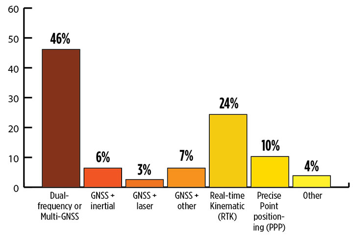
What is the most promising and practical way to gain the increased accuracy that survey and other high-precision applications continue to demand? (Source: GPS World 2018 State of the Industry survey)
Higher Accuracy. Regarding the most promising technology to get the increased accuracy that surveying continues to demand, the outright choice was “dual-frequency, dual- or multi-constellation GNSS,” with “real-time kinematic” coming in second. Surprisingly, the newest technology to be introduced to GNSS receivers, inertial correction, lagged at just over 5%.
Inertial correction devices, which contain gyroscope and accelerometer technology, are now being installed in survey-grade receivers to increase accuracy and productivity. It’s a gamechanger in GNSS data collection for surveyors, so I am surprised by the survey results. These sensors work in conjunction with the receiver to more accurately collect positional information in relation to the point being acquired. While RTK positions are normally collected at 1-20 Hz, the inertial device works in tandem to further refine a more accurate location. As this technology becomes more publicized in phones and other devices, the surveying community will begin to take notice.
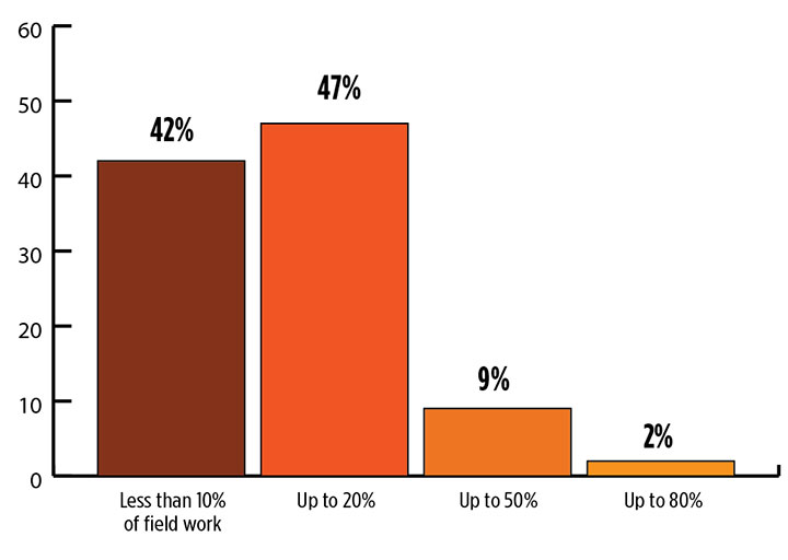
What role will drones (UAVs) play during the next three years in the survey sector? (Source: GPS World 2018 State of the Industry survey)
Drones. Concerning the role that drones (UAVs) will play in the next three years, by a slim margin — 47% to 42% — respondents state that up to 20% of their work will be completed by UAVs vs. those who feel less than 10% of their work will be done by a drone. Only1.3% answered that UAVs will take over most of their work and displace surveyors in the field for specific survey tasks.
I see UAVs becoming a standard equipment much like the EDM/total station and GNSS receivers, as it is clearly a unique tool for not just collecting visual images but as a remote sensing device. While it won’t replace workers in the field, it will allow crews to become more efficient, tech-savvy and valuable for human-only types of data collection.
Business. A whopping 85% of the survey sector found this market either “very healthy, with strong growth” (37%) or “relatively healthy, with moderate growth” (48%). This compares with total of 79% across all GNSS industry sectors. So we’re on top! That is, we are doing comparatively well amid the rest of the GNSS industry — which itself is in very good shape indeed.
Poll results reflect the positive nature of the surveying profession in relation to technology, specifically GNSS and the utilization of UAVs, in our every day work. Previously, introduction of new technology has been historically unreliable, less than user-friendly, and expensive. The trend with newer technologies, however, has been quite the opposite with shorter, easier learning curves and lower cost of entry. These factors have led more surveyors to upgrade their equipment, implementing newer technologies and thus creating more efficiency in the profession.
For more results from the 2018 State of the GNSS Industry, see this page.
TIM BURCH is a professional land surveyor and secretary, Board of Directors, National Society of Professional Surveyors.
The inaugural European Drone Summit will be taking place Oct. 15 in Frankfurt, Germany.
According to event sponsor UAV DACH e.V., the conference will give operators, manufacturers and public authority representatives the chance to gather and discuss the potential modes of operation and applications that are opening up for professional drone service providers and companies in light of the unmanned aircraft industry’s new European general aviation regulation.
Keynote speakers at the event will include Peter van Blyenburgh, UVSI; Max Scheck, Vereinigung Cockpit; Jules Kneepkens, EASA a.D.; Martin Brandenburg, DJI; Andreas Lamprecht, AIRMAP; and Jörg Seebach, DeDrone. The Intel Drone Group’s Anil Nanduri will also present a keynote speech.
“We are delighted that high-ranking experts from different companies, some of whom are even competitors, have accepted our invitation to come on board,” said Michael Wieland from UAV DACH e.V. “Global players’ first-hand experience and solutions offer added value to everyone taking part.”
The goal of the European Drone Summit is to channel ideas and decisions relating to unmanned aircraft systems (UAS) in order to highlight how unmanned aerial vehicle technology can be used now and in the future by representatives of various sectors, organizers said. The summit will take place at the same time as Intergeo, which will take place Oct. 16-18.
Komatsu America Corp. and Propeller Aero Inc. are partnering to boost the efficiency of construction job sites using drone-powered mapping and analytics software.
With drones becoming an increasingly common worksite tool, Komatsu has identified aerial mapping and analytics as a key component of its Smart Construction initiative — a range of integrated hardware and software products designed to offer an end-to-end workflow for each phase of construction.
Komatsu America Corp. spent several years testing various commercial drone mapping and analytics products in North America. In Propeller, Komatsu found a robust product suited to meet the needs of modern construction operations. Propeller expertly balances ease-of-use with survey accuracy and reliability, Komatsu said.
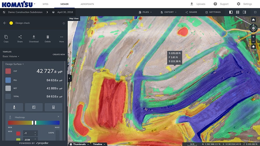
Propeller’s processing machinery crunches thousands of drone images in hours, and delivers the results as a cloud-based 3D model to the user’s desktop or tablet. From there, powerful collaboration and analysis tools let users perform height, volume and slope calculations, and measure change over time to confirm that a project is on track, the companies said.
(Image: PRNewsfoto/Propeller Aero)
Propeller’s technology platform supports multiple coordinate systems, including local site calibrations. This allows personnel to capture up-to-date survey data expressed in the specific geospatial coordinates they already use on that job site. Local grid support is crucial for ensuring drone-captured maps and models match up with plans and previous surveys.
“A Komatsu Smart Construction jobsite by definition is technology enhanced and production optimized,” said Jason Anetsberger, senior product manager at Komatsu America Corp. “Adding Propeller Aero as one of our key partners gives our North American distributors and customers exceptional capabilities to achieve this standard in the aerial mapping space. Propeller combines simple, yet powerful analysis tools with accurate and fast site visualization.”
“Worksites are starting to see the real business value of accurate, up-to-date drone data,” said John Frost, vice president of business development at Propeller. “We drive that value through workflows that enable everyone to understand who’s moved what material, how much, and where. It’s all about empowering worksites with the information they need to make data-driven decisions to reduce costs, ensure quality, and use resources efficiently. Now more than ever, stakeholders on site, or in the head office miles away, can stay up-to-date with exactly what’s happening on the ground.”
“Anyone can fly a drone — it’s what you do with the data that makes an impression,” said Chris Faulhaber, smart construction business manager at Komatsu Equipment Co. “Propeller provides fast, accurate data processing via a web platform that is unparalleled. The platform is easy to use, facilitates healthy collaboration and delivers vital information quickly — so everyone can work together better and faster than anticipated.”
NDCOE’s mission is to save lives and reduce air hazards from drone incursions by empowering a shared safety vision with the the U.S. Federal Aviation Administration’s (FAA’s) integration of drones into the commercial air traffic system.
Located in Las Vegas, with facilities donated by technology infrastructure company Switch, NDCOE will provide safety incursion research data, drone technology best practices and educational materials.
The new center will conduct public workshops that promote and protect the public’s safety and privacy in an open and ethical manner.
Over the last decade, UAS, more commonly referred to as drones, have experienced an unprecedented boom within aviation. Coinciding with the increase in popularity, incidents involving drones in tourist areas, as well as risks to larger manned aircraft are on the rise and present high-liability risks to property owners.
Safe and successful UAS operations rely on quality training, end user education and maximizing public safety processes. To protect and educate residents and visitors, the center seeks to protect against drone users who pose a public safety hazard due to inexperience or malicious drone operations. Such hazards include drones hitting people or that have the potential to cause an airline disaster, and drone operations that violate safety, privacy or drone laws near high-traffic public places, at airports, near military bases or near critical infrastructure.
NDCOE will also advance drone surveillance, detect and avoid (remote sensing), wildland firefighting, gas-leak detection, and time-sensitive medical delivery technologies for life-saving medical equipment and organs.
“In addition to fostering major advances in UAS technology with testing partners like the FAA, NASA and Switch, Nevada is also home to the most registered drone users in the nation in Las Vegas,” said Paul Anderson, executive director of the Nevada Governor’s Office of Economic Development. “This dynamic makes such a program as the Nevada Drone Center of Excellence for Public Safety a natural step as drones increasingly become a bigger part of our daily lives.”
In a recent state-wide Nevada Drone Industry survey by the University of Nevada, Las Vegas (UNLV) and NIAS, the NDCOE received support to open the first center of its kind in the U.S. In the survey, almost 80% of respondents were concerned about a recreational drone hitting an airline and causing an airline disaster, and almost 90% were concerned about aerial drones illegally penetrating FAA airspace without authorization at outdoor events such as sports stadium, concert or at large events.
“We are taking an aggressive approach toward solving the complex UAS Industry challenge of mitigating drone incursions into the National Airspace System — one of the toughest FAA challenges today,” said Chris Walach, senior director, NIAS and the FAA-designated Nevada UAS Test Site. “What we are doing in Nevada will be of immense value to the DOT, FAA, DHS, DOJ, commercial airlines, visitor venues, and the UAS Industry. This new center will help advance infrastructure protections, drone detection innovations, enhance air safety, and expand air commerce in Nevada.”
NIAS and the FAA-designated Nevada Unmanned Aviation Test Site lead the growth of the Nevada UAS industry through business teaming relationships, collaborating with primary research institutions on UAS research and development, and enhancing the Nevada UAS Industry knowledge base to attract new and permanent business and create jobs in the State of Nevada.
Leica Geosystems has released the Leica Aibot, its latest unmanned aerial vehicle (UAV) system based on DJI’s aerial platform, the M600 Pro, designed to rapidly and autonomously enable digitizing of critical infrastructure.
Leica Geosystems’ UAV technology enables users to get a complete data set in less time with a user-friendly and innovative interface, opening new business opportunities while reducing time, costs and effort from with traditional data collection methods.
A proprietary software suite supports the new UAV workflows. Using Leica Infinity for point cloud, digital surface model and orthophoto generation enables surveyors to process and visualize aerial data, increasing productivity and speeding data delivery. Supporting users to share data to Cylcone and Cloudworx, the integration of the UAV point cloud with terrestrial scan data enables informed decisions, while complete data sets increase project efficiency.
Use in construction
Throughout a construction project lifecycle of planning, designing and construction, Aibot provides easy access to critical information to perform volume calculations and monitor site progress. From creating digital terrain models to stripping and bulk earthworks and trenching to finally fine grading, paving and compaction, the solution facilitates actuals comparisons. This provides a more transparent view of site progression monitoring and volume calculations with safer operations, to keep projects on schedule.
High-definition imagery and 3D mapping enable viewing of site mapping or progress documentation, meaning users identify gaps early with high accuracy, and save time and money at all project stages.
Automating operations
The new technology, developed in partnership with UAV manufacturer DJI, allows users to process and analyze millions of data points gathered from above and to visualize the data for actionable information. UAV data can be combined with existing survey technologies, such as TPS, GPS and laser scanning, for a more complete set of information.