Swiss professional drone maker senseFly has launched the eXom, its new quadcopter UAS for mapping and inspection. The eXom is available to pre-order immediately and ships this summer.
The eXom is a sensor-rich system, sensefly said. Developed by experts working across numerous fields of robotics, this lightweight quadcopter offers professionals such as civil engineers and land surveyors the situational awareness, imaging flexibility and durability they need to complete challenging tasks safely, accurately and efficiently.
“We believe the eXom’s level of application-focused technology is unique in the civilian drone market,” said Antoine Beyeler, CTO and co-founder of senseFly. “This platform tightly integrates several one-of-a-kind features, such as TripleView imaging, advanced situational awareness and full flight mode flexibility — to provide inspection and mapping professionals with the functionality they desire from a rotary system.”
eXom is a future-ready platform with a quad-core computer onboard, senseFly said. Like senseFly’s fixed-wing drones, it offers users evolving performance through regular software updates, adding the latest drone tech innovations to keep the eXom at the cutting edge for years to come, the company said.
eXom’s low take-off weight of 1.7 kg (3.7 lb) ensures its users will, in many countries, have less flight authorization paperwork to deal with than those who use heavier systems.
The eXom’s advanced integrated sensors work together to provide the user with full situational awareness and support obstacle avoidance:
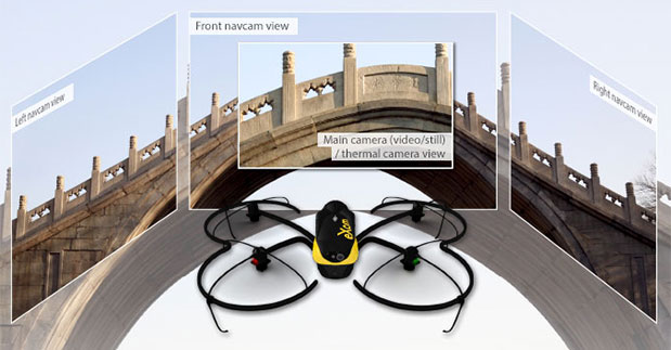
Five navcam vision sensors allow the operator to see in the direction the drone is moving, automatically via its flight control software, without needing to turn the system’s TripleView camera head. This technology is similar to the visual parking sensors in modern cars, but brought into a 3D flight environment.
Five ultrasonic proximity sensors work in harmony with eXom’s navcams to ensure the operator always knows the drone’s distance from nearby objects. (The drone’s shock-absorbent carbon fibre shrouding is also always on hand to protect its rotors in case of surface contact.)
Numerous other sensors, including inertial measurement units, barometers, magnetometers, GPS and magnetic encoders, maximize the drone’s stability and safety.
eXom’s autopilot-controlled TripleView camera head enables the user to view and record three different types of imagery during a single flight without needing to land to change cameras:
HD video
Ultra high-resolution stills
Thermal still/video
Because the TripleView head faces forwards, eXom can fly up close to target structures such as building walls and dams to achieve sub-millimeter data resolutions. Plus, with the head’s 270-degree vertical field of view, users can document objects positioned directly above and below the drone — crucial for tasks such as bridge and roof inspections.
eXom offers various flight modes:
Autonomous mode — for mapping projects. First, create a flight plan using eMotion X’s mission blocks. eXom then launches, flies, acquires geo-referenced imagery and lands itself.
Interactive ScreenFly mode — this streaming video mode is for live inspection tasks. Use the supplied joypad to navigate and orient the drone via computer screen. This mode includes flight assistance features such as cruise control and distance lock.
Create a flight plan, launch in autonomous mode, then go live on demand.
No matter which mode is activated, RC-based manual control always remains available as a backup function and for experienced pilots.
Visit senseFly at Unmanned Systems 2015: Hall B2, Booth 519. The eXom will be demonstrated in flight at the senseFly booth at at the show’s Air & Ground Demo Area (demo timings: May 6, 12:15 and 14:15, May 7, 11:45 and 14:15).
The United States will reach one million unmanned aircraft systems (UAS) flights per day within the next 20 years, given the right regulatory environment, according to new economic research from the Consumer Electronics Association.
Brian Markwalter, senior vice president, market research and standards, CEA, shared the association’s domestic UAS economic analysis at the Unmanned Systems 2015 Conference in Atlanta, Ga.
“This is a billion-dollar technology market literally just waiting to take off,” Markwalter said. “We see a dynamic market with tremendous growth potential, once we have final Federal Aviation Administration (FAA) rules to allow commercial UAS operation, combined with continued industry and FAA cooperation to achieve low-risk, beyond-line-of-sight flights.”
“With the right regulatory environment, drones will be safely integrated into our transportation system — displacing noisy trucks, reducing urban traffic, cutting our fuel consumption and carbon emissions,” said Gary Shapiro, president and CEO, CEA. “This will allow for game-changing innovations such as the quick delivery of life-saving diagnostics and medicine, improvements in crop production and efficiency, and safer work environments for those who inspect and maintain our buildings and bridges.”
According to the CEA research, the U.S. UAS market is indeed growing, but risks falling behind in the global market because of fewer or more progressive regulations in other countries. In fact, as the U.S. awaits further FAA rules regarding the commercial use of UAS, CEA’s research estimates a pent-up market demand of $150-$200 million in UAS sales for “line of sight” operations.
Only hobbyists and the do-it-yourself community now are allowed to fly UAS in the U.S., enough to fuel a robust U.S. consumer market with the potential to reach $250 million by 2018. However, if the FAA remains on track to complete its line-of-sight rules for commercial operators within three years, CEA’s research foresees another $200 million in growth. Additionally, with the continued development of “sense and avoid” technology and FAA rules that foster “beyond-line-of-sight” operations, the United States’ UAS industry could become a $1 billion market.
“The ability for beyond-line-of-sight is the true game changer—opening the door to autonomous UAS operation and unleashing a remarkable economic potential,” said Markwalter. “The United States has a long history of being a technology leader—and we’ve led the world at almost every stage of flight innovation. But we have more work to do on UAS. Realizing these economic gains will require ongoing FAA and industry cooperation, as well as a commitment to the necessary infrastructure.”
CEA market research expects 2015 to be a defining year for unmanned systems, with the category ideally positioned for steady growth. According to CEA projections, the global market for consumer UAS will approach $130 million in revenue in 2015, increasing by more than 50 percent from 2014; with unit sales of consumer UAS expected to approach 425,000, an increase of 65 percent.
“Right now, more than six billion packages are delivered every year in the U.S., weighing less than three pounds apiece on average — perfect candidates for drone delivery,” said Markwalter. “The autonomous operation of UAS for the delivery of everyday items would not only lower the cost for consumers and improve delivery times, but also be a significant driver of our tech economy.”
This year CEA debuted the Unmanned Systems Marketplace at the 2015 International CES, with 15 UAS companies — almost four times as many as last year — covering 7,600 square feet of exhibit space. At CES, Shapiro announced CEA’s support of the UAS safety campaign “Know Before You Fly,” which provides prospective UAS operators with the information and guidance they need to fly safely and responsibly.
The GPS World staff is reporting live from Unmanned Systems 2015, held May 4-7 in Atlanta. The event convenes the global community of commercial and defense leaders in intelligent robotics, drones and unmanned systems, hosted by AUVSI.
Check back throughout the week for event updates, including news, photos, videos, tweets and more.
The Association for Unmanned Vehicle Systems International’s (AUVSI’s) Unmanned Systems 2015 show, held May 4-7 in Atlanta, convenes the global community of commercial and defense leaders in intelligent robotics, drones and unmanned systems.
Jeff Martin of Spirent Federal Systems talks about how its GSS9000 simulator can help with unmanned aircraft system (UAS) development while at Unmanned Systems 2015, held May 4-7 in Atlanta. The GSS9000 simulator supports multi-system, multi-constellation GNSS testing for UAS.
Septentrio has launched the AsteRx-m UAS, an RTK-accurate GNSS receiver solution specially designed for the drone market. The AsteRx-m UAS provides high-accuracy GNSS positioning with low power consumption, according to Septentrio.
The launch of the AsteRx-m UAS board is complemented by the release of GeoTagZ software suite. The GeoTagZ suite works with the UAS camera and image-processing solution to provide centimeter-accurate position tagging of images without the need for a real-time data link.
The AsteRx-m UAS will be on display at booth #635 during AUVSI’s Unmanned Systems 2015, held May 4-7 at the Georgia World Congress Center in Atlanta.
Despite being Septentrio’s smallest receiver, the AsteRx-m UAS provides consistent, robust and accurate positioning from to Septentrio’s in house GNSS+ algorithm technology. The receiver delivers cm-level accuracy at less than 600 mW with GPS and less than 700 mW with GLONASS. LOCK+ technology guarantees tracking under heavy usage and IONO+ guarantees no interference in challenging ionospheric conditions, Septentrio said.
Integration into Any UAS. One of the key characteristics of AsteRx-m UAS and GeoTagZ is the seamless integration into any UAS. AsteRx-m UAS features standard connection functionality that directly connects to a UAS autopilot, such as Pixhawk and Ardupilot. The power comes directly from a number of power sources, including micro USB, a 9-30V external power supply or the vehicle power bus. GeoTagZ is available as a library of software to integrate into an UAS image-processing tool chain.
“We want to make UAS-based data collection and processing extremely simple. AsteRx-m UAS and GeoTagZ do just that,” said Jan Leyssens, commercial product manager at Septentrio. “The GNSS board connects seamlessly to standard hardware and cameras used on a drone. Together with our software, we provide a data collection solution that provides cm-level accuracy without the need for ground control points or real-time data links, and that integrates effortlessly with an existing UAS image processing software solutions.”
DroneMetrex has captured high-quality near-infrared (NIR) mapping data with its TopoDrone-100 UAV. DroneMetrex said in a news release that this is the first time such high quality NIR imagery has been captured by a UAV.
High-quality NIR data is a tool to detect chlorophyll. Because chlorophyll is emitted by all vegetation to various degrees, experts from land and forest departments, agronomists, vignerons and pastoralists will be able to discriminate between health and vigor of vegetation and between different types of vegetation. The data collected helps determine vegetation stress, disease, pest infection, irrigation faults and nutrient variations.
“We say ‘unique high-quality mapping’ because the data are both radiometrically and geometrically unparalleled from a drone,” said Thomas Tadrowski, managing director of DroneMetrex. “From the one-flight sortie, TopoDrone-100 users are able to perform vegetation analysis mapping as well as accurate 3D contours/DTM mapping. The pixel resolution is unsurpassed. The data geometry is unsurpassed. The radiometric mapping is unsurpassed.”
DroneMetrex offers its Extended Spectrum Mapping (ESM) camera modification as an option with the TopoDrone-100. After ESM modification, the camera is supplied with three external screw-on lens filters. Simultaneously using the NIR filter and a high-accuracy L1/L2/L5/GLONASS/COMPASS (BeiDou-2) PPK direct georeferencing solution, the TopoDrone-100 captures three-band imagery, with the near-infrared band recording unparalleled radiometric quality and chlorophyll discrimination.
The high radiometric quality is achieved because DroneMetrex specialists perform the necessary camera modifications themselves, and have designed the external filters specifically to match the requirements of accurate, discriminative vegetation mapping, DroneMetrex said.
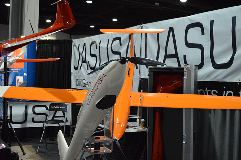
Skip Miller, UASUSA’s founder and CEO, stands with with the Tempest ET.
UASUSA will unveil its payload advancements in booth 631 at AUVSI’s Unmanned Systems 2015, held May 5-7 in Atlanta.
The new Trimble RTK high-accuracy GPS positioning system will be available through UASUSA. It covers up to 2,300 acres per flight for photo mosaic and mapping missions with manufacturer specified sub-centimeter accuracy.
UASUSA also modified its leading aircraft, the Tempest, to create the Tempest ET. The new aircraft has added payload storage interchangeable in the wing tip extensions, yet still offers the same level of stability, endurance, efficiency and aesthetics as the Tempest, UASUSA said.
The Tempest ET is designed for magnetometer use in the mining industry and offers interchangeable regular, extended and payload tips. With its 10- to 15-pound payload capacity, it may carry the Phoenix Aerial LiDAR system to cover large areas and create survey-grade point clouds.
DroneDeploy, a start-up provider of cloud-based software solutions for commercial drone operations, has launched its mobile app. The app automates drones and receive real-time, reliable, detailed aerial maps and images. Also, through a partnership with DJI, DroneDeploy’s software is now offered on the DJI Phantom 2 Vision+, making it available to end users in agriculture, real estate, mining, construction and other commercial and consumer industries.
DroneDeploy’s new mobile software lets users control drones and cameras while in flight, and is the first solution to process data, information and visuals in real-time. The solution makes simple, real-time mapping, with guaranteed accuracy and one-click automated results, available anytime, anywhere.
“DroneDeploy has created a custom mobile application for the DJI Phantom 2 Vision+ that provides a remarkable live mapping platform, autonomous flight, and aerial data capture capabilities,” said Eric Cheng, general manager, DJI San Francisco and director of aerial imaging, DJI. “We are proud to partner with DroneDeploy, and are excited about the future of autonomous aerial imaging platforms.”
Using the DroneDeploy app, farmers and agronomists can now quickly assess and diagnose crop health, detect field variations, categorize yield zones and analyze NDVI outputs for smarter farming decisions. Construction and mining operators can easily generate high-resolution 3D or digital elevation models of sites and structures, and analyze plan progress to eliminate inconsistencies.
“The introduction of our mobile application marks a first in the adoption of drones for commercial use. DroneDeploy makes it possible for users without any training to access and employ drone-based aerial imagery and mapping. Our mobile app is faster, more affordable, easier and more accessible than any other solution on the market today,” said Mike Winn, DroneDeploy’s co-founder and CEO.
DroneDeploy will be exhibiting at booth 2048 at the AUVSI’s Unmanned Systems 2015, held May 5-7 in Atlanta.
Aeryon Labs, GlobalMedic and Monadrone are working together to deploy three unmanned aerial systems (UAS) in Nepal to help locate earthquake survivors. The drones are outfitted with thermal cameras and the Aeryon HDZoom30 camera, which has an extended zoom, to look at targets from more than 1,000 feet away.
On Saturday, April 25, a 7.8 magnitude earthquake struck Nepal — the largest quake in 81 years in the region. More than 4,000 people have died, with death tolls expected to rise as the rubble is cleared.
In response, Aeryon Labs deployed three of its sUAS (small UAS) and a qualified Aeryon pilot to the affected region. Aeryon is collaborating with partners GlobalMedic and Monadrone to provide aerial support to international disaster relief teams on the ground.
The Global Medic UAV team responded immediately to the crisis in Nepal. “sUAS provide us the unmatched capability to get onsite and into the air immediately to start determining how and where to provide support to the people,” said Rahul Singh, executive director of GlobalMedic.
Damage to, or the complete loss of, fundamental infrastructure such as airstrips and refueling facilities can make manned aircraft operations in disaster relief scenarios very challenging. Sending rescue workers into damaged structures, or rubble piles, to search for survivors also puts them in harm’s way. sUAS enable ground-based rescue teams to collect critical visual intelligence and deploy rescue resources quickly, carefully and exactly where they are most needed, the companies said.
The Aeryon HDZoom30 is a fully-integrated, ruggedized, high performance electro-optical camera payload for UAS.
The Aeryon sUAS being sent to Nepal are equipped with thermal cameras to help locate survivors by detecting body heat, as well as the companies newest imaging payload, the Aeryon HDZoom30, which can be used at extended distances to zoom in to see a target with clarity and detail. For example, operators are able to recognize a face from more than 1,000 feet (300 meters) away. The team will also undertake aerial mapping of the affected areas, building 2D and 3D maps, so that further response efforts can be planned.
“At Monadrone, we see sUAS as mission-critical tools that not only support day-to-day military, police and fire department needs, but can also play a vital role when disaster strikes,” said Robin Morris, director at Monadrone, Monaco. “The images the Aeryon sUAS will capture will enable the creation of up-to-date maps required to aid the disaster relief in Nepal.”
Aeryon sUAS were also deployed in the aftermath of the August 2014 landslide that devastated the region along the banks of the Sunkoshi River in northern Nepal. Despite the high altitude of Nepal, which is challenging for many aircraft, and the rugged terrain, Aeryon sUAS proved effective and more than up to the task.
“UAS are uniquely able to provide immediate support for disaster relief, like the earthquake in Nepal, helping rescue teams search more effectively, efficiently and safely,” Dave Kroetsch, president and CEO of Aeryon Labs, told AUVSI News. “It’s an honor to see the technology you create make such a difference. We are privileged to be able assist the aid workers who are helping the people of Nepal.”
Great view of the Pentagon while departing from the U.S. Hydro conference held in Washington, D.C.
I’ve attended five conferences in the past couple of months; Esri Water Conference (first one!), Esri Partner Conference, US Hydro 2015, APSG (Association of Petroleum Surveying & Geomatics) and the Esri Petroleum User Group (PUG) conference. It may look Esri-heavy, but the fact is that Esri is doing a really good job of organizing vertical market GIS conferences, and people are showing up. Even with crude oil prices in the cellar (relatively speaking), 1,200 people still showed up at the PUG.
There were a lot of good presentations at these conferences, and I’ll post links to some of them below. Not surprisingly, drones are a major topic of discussion at most GIS conferences. There was even a drone demo (I missed) at the Esri Partner conference showing Esri’s workflow in working with drone-collected data.
If you don’t follow me on Twitter, you might consider it. Twitter is easy and free. When I’m at a conference, I send tweets (most with a photo) in near real-time when I see something of interest. For example, I tweeted when Jack Dangermond showed up at the Esri PUG (he usually doesn’t, but did this year because it was the 25th annual conference) and had something interesting to say (read below). You can sign up for Twitter here, and then choose to follow me at https://twitter.com/GPSGIS_Eric. I get that you may be hesitant to invest any time in this, but it looks like Twitter is becoming the standard for near real-time news (as opposed to other social media such as Facebook or LinkedIn.)
Of all the new technology I’ve heard about over the past few months at these conferences, two subjects continue to excite me.
Drone Mapping. Of course, one of them is drone technology for mapping. It seems like I’ve beat this horse to death over the past few months, but it continues to get juicier and juicier. Technology development in this industry is moving really fast. It seems like new drones are being announced as frequently as new smartphones, maybe more so.
Other ancillary technologies are being developed to support commercial drone operations. For example, in my hometown (Portland, Ore.), a company called Skyward just raised $4+ million in venture capital funding to provide “professional services for UAV operations.” Essentially, the company’s software helps drone operators stay within FAA regulatory compliance.
Last year, the Oregon Unmanned Systems Business Enterprise was formed “with a two-year $882,000 state grant from the Oregon Business Development Department and the Oregon Innovation Council and will be working to match the government money with private investment and other grants.” The organization will award grants up to $75,000. The point is, the money is flowing and it’s a wide-open market.
The drone market is so wide open, in fact, that most drone companies are just buying common airframes and associated parts, putting their brand name on them, and selling them. Perhaps oversimplified, but the point is there’s not much “special sauce” (technology) being added. The manufacturers that aren’t innovating and adding valuable “special sauce” will eventually disappear. Essentially, following are the parts needed for a fixed-wing drone for mapping:
Aircraft components:
Airframe (off the shelf)
Motor (off the shelf)
Servos (off the shelf)
Propeller (off the shelf)
Radio (off the shelf)
GPS (off the shelf)
Autopilot (off the shelf)
Batteries (off the shelf)
Camera trigger (off the shelf)
Camera (off the shelf)
Ground compoments:
900-MHz controller (off the shelf)
Battery chargers (off the shelf)
Mission planning software (off the shelf)
Propeller balancer (off the shelf)
As you can see, all of these components are available off the shelf. You can order each component (maybe all of them from Amazon!), have them shipped to you, and assemble your own UAS for mapping. That said, someone who has gone through the process of building, flying and producing a valuable deliverable that you can make decisions from can add value. But, as competition increases, there’s no doubt that the companies that don’t offer much added value will not be able to operate a sustainable business.
Finally, the U.S. Federal Aviation Administration (FAA) is being surprisingly nimble, approving “333 Exemption” requests at record pace and moving towards using a “summary grant” process to issue bulk approvals of 333 Exemption requests for commercial operations.
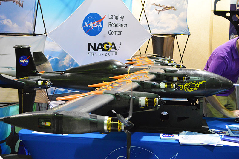
UAS presentation from Texas A&M University, one of six FAA-designated UAS test sites.
You may want to take a look at some of the other presentations at the APSG meeting. They were very good. Here’s a quick summary of each by Jon Stigant, long-time member of APSG:
This was a primer in LiDAR technology and methodology — while most of the paper is well understood in the survey community, it is and excellent overview. A reminder for some and a way to fill in the gaps for those not so close to this technology.
Integration of UAVs into O&G Operations — Stacey Lyle, BP (presentation forthcoming)
Stacey provided a valuable summary of the direction in which the FAA is going to regulate the emerging UAV technology. A “must read” for any company that intends to either provide or use this technology. As with most government regulation there is a lot of detail, the devil is in them. Stacey recommended that the APSG engage by developing some standards for the oil and gas industry.
Ron Hughes theme is massive data and managing it — also something of a common theme for all the talks. He focused on automating data processing and recommended a concept of doing this in an automated way with 80 percent of the data. This requires careful procedural development in collaboration with a given client’s business workflows. He gave an example of a large utility company, and how the development of an enterprise metadata server had functional impact for individual business units, but also had the knock on impact of improving inter-functional/inter-community collaboration within the enterprise.
Mike provided input on Geiger mode LiDAR, differentiating Harris’ approach from the more regular LiDAR methodology. The major difference is in data density, data frequency, volume and speed used from higher flying aircraft covering a larger area faster. Providing 10-cm accuracy and expecting 7-cm acuracy development using a/c at 25,000-ft height. Focus on fast processing of immense data volumes (pedabytes) – 24-hour delivery using Harris proprietary processing. Achieve higher density at lower cost.
Mark introduced developments in GIS associated with Common Operating Picture (COP), focusing on the combining of video and data in GIS system. DPFOS mnemonic: Data Management, Planning & Analysis, Field Mobility, Operational Awareness, Stakeholder Engagement. A new SIMOPS (SIMultaneous OperationS). The key is a single source of approved data. Examples of data required in COP from specific disciplines are provided — ROVs, shore clean-up, life of field data, asset and material tracking, live/recorded video, RT data and weather integration, “in the field’” vessel implementation.
GIS, Geospatial, Geomatics…Organizational Capability Evolution — Brian Boulmay, BP (presentation forthcoming)
Rethinking Geospatial Data Management at a major operator. One Map program — not physical, one-way provision. Focus on users vs. geospatial specialists. Users business driven, specialists IT and S driven. Geospatial data integrity and analytics – people, processes and technology. ID goals — massive deployment worldwide — has to be automated. Federated system — regions only have to deal with their own regional data, not be overwhelmed by whole enterprise on their doorstep. IT has the role of providing/maintaining a worldwide solution.
Update on Spring 2014 APSG meeting — All major networks launching satellites. Very soon will have 30 live in-view satellites (U.S., Russia, Europe and China). RTK coverage in China is the best due to BeiDou, supplemented by both Indian and Japanese systems SBAS. $100 RTK on cell phone giving centimeter accuracy eventually, and changing the commercial dynamic!
Set up for managing and analyzing LiDAR data in Global Mapper. Workflows: terrain modeling, visibility, biomass (change monitoring); asset: inspect and maintain pipelines, as-built modeling, simulation. High-accuracy at relatively low cost, outpacing regulatory management. Much public data available — earthexplorer.usgs.gov. xyz values — minimum height threshold, dense RGB point cloud (almost photographic).
Automated dashboard approach, reducing pilot distraction risk, speeding up RT transfer and operational activity reporting.
Esri Conferences
Here are a couple of neat things from the Esri conferences.
First, Jack Dangermond was his usual visionary self at the Esri PUG conference, making his appearance for the 25th annual PUG. He is a master at communicating his GIS vision.
The Evolution of GIS.
In speaking about the evolution of GIS, Mr. Dangermond spoke about the far-reaching impact of email and stated that eventually web-based GIS will be deployed organization-wide, just like email. I agree with this vision. I believe the only question is timing. Is it two years from now? Five years from now? 10 years?
Onto the less visionary and more tactical tidbits…
Of particular interest to me is high-precision GNSS in the Esri environment. A lot of people I talk to are screaming for this. What does high-precision GNSS in the Esri environment mean?
support for high-precision metadata in ArcGIS Collector (ArcPad already supports this).
support for high-precision horizontal (eventually vertical) datum transformations in ArcGIS Collector.
This is important because Esri is supporting ArcGIS Collector across all mobile platforms (Android, iOS and eventually Windows), and people want to use their smartphones and tablets. ArcPad will never run on iOS or Android, so Collector is the GIS collection tool of choice, at least for the Esri environment. It needs to support high-precision GNSS, and by the looks of the following slide, it will. It’s just a matter of timing…
ArcGIS Collector to support high-precision GNSS.
The other potentially neat product Esri announced was Navigator for ArcGIS. Imagine trying to guide a work crew to a buried valve across town (or in the next neighborhood). Displaying a system or region-wide map of valves would not be an efficient way of driving your way across town to find the valve. However, giving a crew turn-by-turn street directions to the street-level, then displaying the valves on that street section, might be a very efficient way of finding the valve.
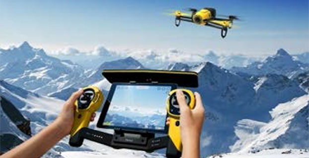
Parrot’s quadcopter Bebop Drone has Furuno inside.
Furuno Electric Co.’s latest multi-GNSS receiver module, GN-87, has been adopted for the new quadcopter Bebop Drone, made by Parrot SA. Parrot develops advanced technology wireless products.
The GN-87 can receive GPS, GLONASS, SBAS, and QZSS concurrently, which significantly improves positioning success rate and robustness against interferences by using different frequency bands, Furuno said.
Parrot Bebop Drone, equipped with a 14-megapixel fisheye lens camera, takes video and pictures in a 180-degree field. The drone integrates mechanical and digital systems, like shock absorbers that cushion engine vibrations and algorithms for an exclusive 3-axis image stabilization, meaning that the angle of the view remains fixed, without distortion, regardless of the inclination of the drone and movement caused by turbulence. The combination of numerous sensors gives the drone impressive stability and great maneuverability when piloted via Wi-Fi with a smartphone and a tablet, or with its Wi-Fi extender, Parrot Skycontroller.
Furuno’s GN-87 supports sensing for autonomous flying according to flight routes preset on the map application by user, automatic return to takeoff position, recording flight path data for 3D modeling on Parrot Academy map. According to Parrot, selecting Furuno’s GN-87 multi-GNSS receiver module enabled simple integration with a high-performance GNSS receiver module while guaranteeing high quality and high volume supply availability.