The Association for Unmanned Vehicle Systems International (AUVSI) will host Unmanned Systems 2015, which will run from May 4-7 at the Georgia World Congress Center Atlanta. With 8,000 attendees from around the world, Unmanned Systems 2015 is the largest expo and trade show in the industry, according to AUVSI.
The event will include three days of interactive exhibits and exciting demonstrations of air and ground vehicles spread throughout 350,000 square feet of exhibit space. The 150-plus educational sessions, workshops, and panel presentations will focus on the future of commercial, humanitarian, environmental, governmental, and military applications for robotics and unmanned systems. For more information on the sessions, see AUVSI’s Program Planner.
This year’s conference will feature keynote addresses and panel discussions by:
Colin Guinn, chief robotics officer, 3D Robotics
Dave Vos, project lead, Project Wing @ GoogleX
David Vigilante, senior vice president, legal, CNN
Helen Greiner, CEO, CyPhy Works
Hugh Herr, MIT professor and head of biomechatroinics at the MIT Media Lab
Rep. Frank Lobiondo, New Jersey House of Representatives
Henrik I. Christensen, distinguished professor, KUKA chair of Robotics, and director of the Robotics & Intelligent Machines Center, Georgia Tech
For more information and a full agenda of events, visit www.auvsishow.org.
DARPA is looking for technology communities that can team to provide expertise and innovation for small sensors, expendable and small unmanned systems, and distributed communications and navigation technology.
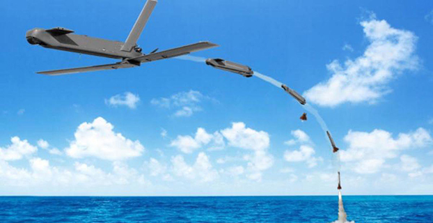
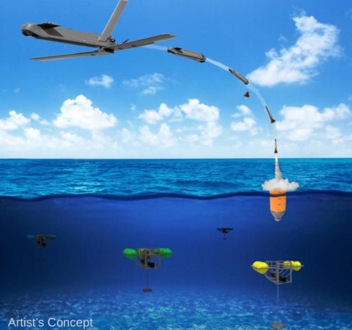
The Defense Advanced Research Projects Agency (DARPA) is researching a drone that can hibernate on the ocean floor for years at a time before being launched to the surface and into the air.
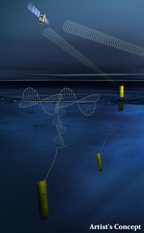
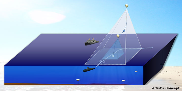
The “Upward Falling Payload” (UFP) concept centers on developing deployable, unmanned, nonlethal distributed systems that lie on the deep-ocean floor in special containers for years at a time. These deep-sea nodes could be remotely activated when needed and recalled to the surface. As DARPA terms it, they “fall upward.”
The new drones are part of a new focus by the U.S. military to develop and improve technology for emerging threats. “Today, cost and complexity limit the Navy to fewer weapons systems and platforms, causing strain on resources that must operate over vast maritime areas. Unmanned systems and sensors are commonly envisioned to fill coverage gaps and take action at a distance. However, power and logistics to deliver these systems over vast ocean areas limit their utility. The Upward Falling Payload (UFP) program intends to overcome these barriers,” DARPA said on its website.
DARPA’s statement continues: “Nearly 50 percent of the world’s oceans are deeper than 4 km, which provides vast areas for concealment and storage. As a consequence, the cost to retrieve UFP nodes is asymmetric with the likely cost to produce and distribute them to the seafloor. Concealment provided by the sea also provides the opportunity to quickly engage remote assets that may have been dormant and undetected for long periods of time, while its vastness allows simultaneous operation across great distances. Getting close to objects without warning, and instantiating distributed systems without delay, are key attributes of UFP capability.”
The UFP system would have three key subsystems:
The payload, which executes waterborne or airborne applications after being deployed to the surface
The UFP riser, which provides pressure tolerant encapsulation and launch of the payload
The UFP communications, which trigger the UFP riser to launch.
The program would need to demonstrate a system that can:
survive for years under extreme pressure
be triggered reliably from standoff commands
rapidly rise through a water column and deploy its payload.
The drones wouldn’t require fuel, as they would be powered with energy generated by ocean currents. Ocean drones would be difficult to manufacture, however, because researchers would need to figure out how to activate the drone, how to help the drone breach the surface, and make sure the drone is protected in salt water for long periods.
This artist’s concept shows a potential communications application of an upward falling payload. (Credit: DARPA)
Phase 2. The program is completing its first phase and is about to enter its second. During Phase 1, DARPA supported more than 10 study and design efforts to figure out approaches for long-range communications, deep-ocean high-pressure containment, and payload launch. The study teams also addressed a variety of missions for the payloads.
“In this first phase, we really learned about how the pieces come together, and built a community of developers to think differently about unmanned distributed solutions for the maritime domain,” said Andy Coon, DARPA Program Manager for the effort. “The trick is to show how these systems offer lower-cost alternatives to traditional approaches, and that they scale well to large open-ocean areas.”
In the next Phase, DARPA intends to learn from the studies, and develop and demonstrate prototype systems. DARPA is seeking teams to develop UFP nodes that combine expertise in both deep-ocean engineering and advanced payload development.
“We’re also looking for the communications technologies for these nodes. As long as you can command the nodes remotely and quickly, and don’t have to send a ship out to launch it, you’re in good shape. Some Phase 1 approaches were more exotic than others, but we were pleased by the range of challenging options,” said Coon.
In today’s fiscally constrained environment, such a system of pre-positioned, deep-sea nodes could provide a full range of maritime mission sets that are more cost-effective than existing manned or long-range unmanned naval assets.
For Phase 2, DARPA is particularly looking for technology communities that can team to provide expertise and innovation for small sensors, expendable and small unmanned systems, distributed communications and navigation technology, novel long-range underwater communications, and long-endurance mechanical and electrical systems that can survive for years in dormant states.
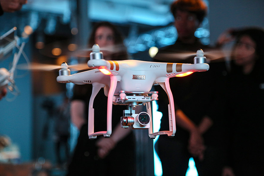
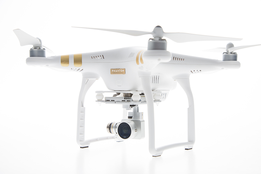
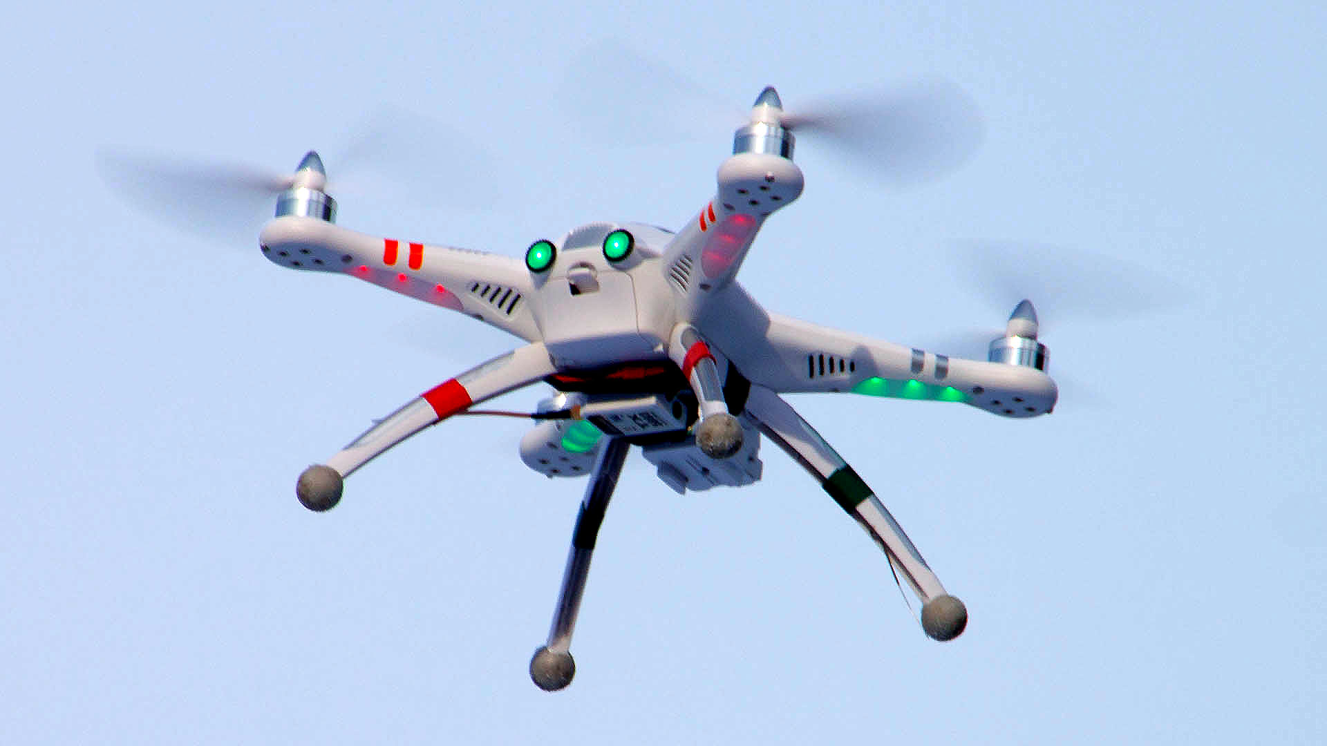
DJI has launched a new drone in its Phantom series. The Phantom 3 comes in two variations, Professional and Advanced, both of which provide greater control and creative options than the popular Phantom 2. On April 8, DJI held three simultaneous events in London, Munich, and New York to mark the release of the Phantom 3.
Both Phantom 3 versions feature the strongest professional control features DJI has developed so far. Using DJI’s Visual Positioning system, the Phantom 3 can hold its positioning indoors without GPS and can easily take off and land with the push of a button. With Vision Positioning technology, visual and ultrasonic sensors scan the ground beneath the Phantom 3 for patterns, enabling it to identify its position and move accurately.
DJI’s Lightbridge technology is also integrated, enabling control at up to 1.2 miles (2 km) away and a live HD video stream from the camera with almost no latency.
“In developing the next generation Phantom, DJI remained committed to providing a top-tier flight experience in one easy-to-use platform,” said DJI CEO Frank Wang. “We pride ourselves in creating a flying camera that fits in a backpack and can be ready to take professional quality videos from the sky in less than a minute.”
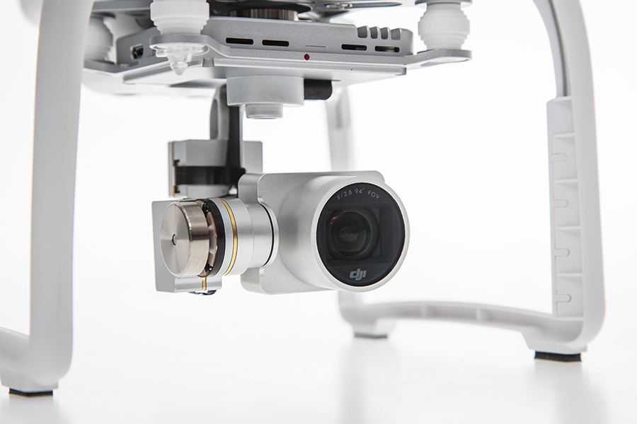
The Phantom 3 Professional is capable of shooting 4K video at up to 30 frames per second, while the Phantom 3 Advanced records at resolutions up to 1080p at 60 frames per second. These cameras are stabilized using 3-axis gimbals to keep the video smooth regardless of flight or wind conditions.
Both models shoot 12-megapixel photos using a 94-degree FOV, distortion-free lens, and a high-quality, 1/2.3-inch sensor that is more sensitive to light than the sensor in previous Phantom 2 Vision models.
All camera settings — including ISO, shutter speed and exposure compensation — can be set using both the DJI Pilot app and the physical controls on the remote controllers. The DJI Pilot app also features a Phantom 3 flight simulator for virtually practicing aerial maneuvers, and a Director feature, which automatically edits the best shots from flights into short videos that can be shared immediately after landing. The upgraded app also allows pilots to livestream their flights to YouTube.
“Pilots, whether they are journalists, extreme athletes, or global travelers — will not just be able to share aerial videos of where they were, but will also be able to send a YouTube link to their friends and colleagues to show them the aerial perspectives of where they are right now,” said DJI’s San Francisco General Manager Eric Cheng. “This has tremendous potential for changing the way we share experiences with one another.”
DJI has launched a new drone in its Phantom series. The Phantom 3 comes in two variations, Professional and Advanced, both of which provide greater control and creative options than the popular Phantom 2. On April 8, DJI held three simultaneous events in London, Munich, and New York to mark the release of the Phantom 3.
Both Phantom 3 versions feature the strongest professional control features DJI has developed so far. Using DJI’s Visual Positioning system, the Phantom 3 can hold its positioning indoors without GPS and can easily take off and land with the push of a button. With Vision Positioning technology, visual and ultrasonic sensors scan the ground beneath the Phantom 3 for patterns, enabling it to identify its position and move accurately.
DJI’s Lightbridge technology is also integrated, enabling control at up to 1.2 miles (2 km) away and a live HD video stream from the camera with almost no latency.
“In developing the next generation Phantom, DJI remained committed to providing a top-tier flight experience in one easy-to-use platform,” said DJI CEO Frank Wang. “We pride ourselves in creating a flying camera that fits in a backpack and can be ready to take professional quality videos from the sky in less than a minute.”
The Phantom 3 Professional is capable of shooting 4K video at up to 30 frames per second, while the Phantom 3 Advanced records at resolutions up to 1080p at 60 frames per second. These cameras are stabilized using 3-axis gimbals to keep the video smooth regardless of flight or wind conditions.
Both models shoot 12-megapixel photos using a 94-degree FOV, distortion-free lens, and a high-quality, 1/2.3-inch sensor that is more sensitive to light than the sensor in previous Phantom 2 Vision models.
All camera settings — including ISO, shutter speed and exposure compensation — can be set using both the DJI Pilot app and the physical controls on the remote controllers. The DJI Pilot app also features a Phantom 3 flight simulator for virtually practicing aerial maneuvers, and a Director feature, which automatically edits the best shots from flights into short videos that can be shared immediately after landing. The upgraded app also allows pilots to livestream their flights to YouTube.
“Pilots, whether they are journalists, extreme athletes, or global travelers — will not just be able to share aerial videos of where they were, but will also be able to send a YouTube link to their friends and colleagues to show them the aerial perspectives of where they are right now,” said DJI’s San Francisco General Manager Eric Cheng. “This has tremendous potential for changing the way we share experiences with one another.”
The Federal Aviation Administration has issued an experimental airworthiness certificate to an Amazon Logistics, Inc. unmanned aircraft (UAS) design that Amazon will use for research and development and crew training. Amazon has said it wants to use drones for delivering packages to customers.
The FAA typically issues experimental certificates to manufacturers and technology developers to operate a UAS that does not have a type certificate.
Under the provisions of the certificate, all flight operations must be conducted at 400 feet or below during daylight hours in visual meteorological conditions. The UAS must always remain within visual line-of-sight of the pilot and observer. The pilot actually flying the aircraft must have at least a private pilot’s certificate and current medical certification.
The certificate also requires Amazon to provide monthly data to the FAA. The company must report the number of flights conducted, pilot duty time per flight, unusual hardware or software malfunctions, any deviations from air traffic controllers’ instructions, and any unintended loss of communication links. The FAA includes these reporting requirements in all UAS experimental airworthiness certificates.
Technology that allows a drone to be piloted using a person’s brainwaves has been demonstrated in Portugal, reports BBC News. Drone specialist Tekever adapted existing electroencephalography (EEG) technology to enable a pilot on the ground to send instructions to the drone software, a technology it calls Brainflight.
Tekever told BBC News that the technology could enable people with restricted movement to control a UAV. Tekever believes the technology could eventually be used to pilot cargo planes, but experts say safety concerns will be a major roadblock.
Drone World Expo, an event for commercial drone technologies and applications, is partnering with MAPPS to bring together stakeholders, constituents, and all levels of government in the surveying, mapping, and geospatial fields. The MAPPS Conference will be held as a part of Drone World Expo, set for November 17-18 at the San Jose, Calif., Convention Center.
“With all of the exciting developments taking place in the UAV industry, we are thrilled to bring the breadth and depth of knowledge from MAPPS to our event,” said Joel Davis, CEO, JD Events, producers of the show. “Attendees to the MAPPS conference will have free access to the Drone World Expo trade show floor, general sessions and networking events, and we look forward to welcoming their members to this must-attend event.”
The MAPPS Conference will be a forum for discussion on issues and policies, sharing of information and provision of education, and collaboration, specifically related to the geospatial applications of UAV technology.
“MAPPS is thrilled to be part of Drone World Expo,” said John Palatiello, MAPPS executive director. “We believe UAVs will play an integral role in the future of surveying and mapping, and it is vitally important we lead the discussion in terms of investment, technology, applications and regulations. MAPPS looks forward to presenting quality content on the geospatial market for UAVs at Drone World Expo.”
In addition to the MAPPS Conference, Drone World Expo will also offer a two-day conference that will feature sessions and case studies addressing data collection and processing, sensors, piloting and safety management, FAA updates, certification standards, and commercial strategies, and will offer informative sessions on the impact drones are having on geographic information systems (GIS), Big Data and the Internet of Things (IoT).
The Drone World Expo Conference is being developed with the help of an advisory board on which Palatiello serves.
A Walkera QR X350 quadcopter. (Photo credit: Wikimedia Commons).
The Federal Aviation Administration has proposed a framework of regulations that would allow routine use of certain small unmanned aircraft systems (UAS) in today’s aviation system for commercial purposes.
“We have tried to be flexible in writing these rules,” said FAA Administrator Michael Huerta in a statement. “We want to maintain today’s outstanding level of aviation safety without placing an undue regulatory burden on an emerging industry.”
The FAA proposal offers safety rules for UAS under 55 pounds conducting “non-recreational” operations. The rule would limit flights to daylight and visual line-of-sight operations. It also addresses height restrictions, operator certification, optional use of a visual observer, aircraft registration and marking, and operational limits.
The proposed rules also includes extensive discussion of the possibility of an additional, more flexible framework for “micro” UAS under 4.4 pounds. The FAA is asking the public to comment on this possible classification to determine whether it should include this option as part of a final rule. The FAA is also asking for comment about how the agency can further leverage the UAS test site program and an upcoming UAS Center of Excellence to further spur innovation at “innovation zones.”
The public will be able to comment on the proposed regulation for 60 days from the date of publication in the Federal Register. The FAA also intends to hold public meetings to discuss innovation and opportunities at the test sites and Center of Excellence. These meetings will be announced in a future Federal Register notice.
“Technology is advancing at an unprecedented pace, and this milestone allows federal regulations and the use of our national airspace to evolve to safely accommodate innovation,” said Transportation Secretary Anthony Foxx.
The proposed rule would require an operator to maintain visual line of sight of a small UAS. The rule would allow, but not require, an operator to work with a visual observer who would maintain constant visual contact with the aircraft. The operator would still need to be able to see the UAS with unaided vision (except for glasses). The FAA is asking for comments on whether the rules should permit operations beyond line of sight, and if so, what the appropriate limits should be.
Under the proposed rule, the person actually flying a small UAS would be an “operator.” An operator would have to be at least 17 years old, pass an aeronautical knowledge test and obtain an FAA UAS operator certificate. To maintain certification, the operator would have to pass the FAA knowledge tests every 24 months. A small UAS operator would not need any further private pilot certifications (such as a private pilot license or medical rating).
The new rule also proposes operating limitations designed to minimize risks to other aircraft and people and property on the ground:
A small UAS operator must always see and avoid manned aircraft. If there is a risk of collision, the UAS operator must be the first to maneuver away.
The operator must discontinue the flight when continuing would pose a hazard to other aircraft, people or property.
A small UAS operator must assess weather conditions, airspace restrictions and the location of people to lessen risks if he or she loses control of the UAS.
A small UAS may not fly over people, except those directly involved with the flight.
Flights should be limited to 500 feet altitude and no faster than 100 mph.
Operators must stay out of airport flight paths and restricted airspace areas, and obey any FAA Temporary Flight Restrictions (TFRs).
The proposed rule maintains the existing prohibition against operating in a careless or reckless manner. It also would bar an operator from allowing any object to be dropped from the UAS.
Operators would be responsible for ensuring an aircraft is safe before flying, but the FAA is not proposing that small UAS comply with current agency airworthiness standards or aircraft certification. For example, an operator would have to perform a preflight inspection that includes checking the communications link between the control station and the UAS. Small UAS with FAA-certificated components also could be subject to agency airworthiness directives.
The new rules would not apply to model aircraft. However, model aircraft operators must continue to satisfy all of the criteria specified in Sec. 336 of Public Law 112-95, including the stipulation that they be operated only for hobby or recreational purposes. Generally speaking, the new rules would not apply to government aircraft operations, because we expect that these government operations will typically continue to actively operate under the Certificate of Waiver or Authorization (COA) process unless the operator opts to comply with and fly under the new small UAS regulations.
In addition to this proposal, earlier today, the White House issued a Presidential Memorandum concerning transparency, accountability, and privacy, civil rights, and civil liberties protections for the Federal Government’s use of UAS in the national airspace system, which directs the initiation of a multi-stakeholder engagement process to develop a framework for privacy, accountability, and transparency issues concerning commercial and private UAS use.
The current unmanned aircraft rules remain in place until the FAA implements a final new rule. The FAA encourages new operators to visit www.knowbeforeyoufly.org.
The Lehmann L-A 300 drone is designed for mapping.
Lehmann Aviation has rolled out a new version of its OperationCenter, a flight preparation and mission control software program for automatic orthomosaic flights. Also, the company dropped the price for its L-A 300 fully automatic professional drone designed for mapping, because of an uptick in demand and increased production.
The new version of Lehmann OpsCenter, designed for Windows 8.1 tablets and PCs, now includes:
New mission control functions (holding, auto return, non-flying zone)
Terrain awareness during mission preparation, for safer flights in mountain areas
Integration with Google Earth for flight preparation and replay
New easier upgrade and update procedures directly through the web
New options to manage new cameras (GoPro, Canon) for orthomosaics and surveying.
Priced at $2,890, the L-A 300 is a professional drone designed for accurate mapping and digital elevation models (DEMs) that works with the GoPro, Canon S110 and multispectral cameras. It flies automatically for 30 to 45 minutes at a trajectory pre-prepared by the user in the OpsCenter (the range is 18.5 miles).
“In 2014 we significantly increased our production volume thanks to numerous orders from all around the world,” said Benjamin Lehmann, founder and CEO of Lehmann Aviation. “This enabled us to reduce the price for our best-sellers, all L-A-series drones. We also made the decision to follow our strategy of offering really high-tech aerial solutions at fair prices.”
Aerial photographer Raphael Pirker has settled the civil penalty proceeding brought by the U.S. Federal Aviation Administration in 2013 concerning his flight of a styrofoam Zephyr II model aircraft (or “drone”) at the University of Virginia at Charlottesville in October 2011.
The $1,100 settlement “does not constitute an admission of any of the allegations in the case or an admission of any regulatory violation,” Pinker’s attorney Brendan Schulman said in a statement.
On December 1, the National Transportation Safety Board ruled in favor of the FAA, when the FAA appealed a decision by an NTSB Administrative Law Judge in Huerta v. Pirker after the judge dismissed the FAA’s order requiring Pirker to pay a civil penalty of $10,000 for operating an unmanned aircraft in a careless or reckless manner at the University of Virginia in October 2011.
Pinker was said to have been hired to supply aerial photographs and video of the university campus and medical center. He had argued that his aircraft, which was described as an UAS, was in fact a model aircraft.
Schulman wrote: “We are pleased that the case ignited an important international conversation about the civilian use of drones, the appropriate level of governmental regulation concerning this new technology, and even spurred the regulators to open new paths to the approval of certain commercial drone operations.
“The decision to settle the case was not an easy one, but the length of time that would be needed to pursue further proceedings and appeals, and the FAA’s new reliance on a statute that post-dates Raphael’s flight, have diminished the utility of the case to assist the commercial drone industry in its regulatory struggle.”
The Federal Aviation Administration (FAA) declared today that Super Bowl XLIX will be a “No Drone Zone.”
“Many familiar sounds are associated with the Super Bowl: Cheering fans. Referee whistles. The spectacular halftime show. Booming fireworks,” the FAA wrote. “But one sound you shouldn’t hear is the whirring of an unmanned aircraft overhead. The Super Bowl is strictly a ‘No Drone Zone’.” The restriction applies to University of Phoenix Stadium in Glendale, Arizona, during the game.
The FAA bars unauthorized aircraft — including drones — from flying over or near NFL regular- and post-season football games. The same restriction applies to NCAA college games in stadiums seating 30,000 or more fans, Major League Baseball games and many NASCAR events. Other unauthorized aircraft include airplanes, hang gliders, hot air balloons, and model rockets.
The FAA Notice to Airmen makes it crystal clear that anyone violating the rules may be “intercepted, detained and interviewed” by law enforcement or security personnel. Besides possibly landing a violator in jail, flying an unmanned aircraft over a crowded stadium could result in an FAA civil penalty for “careless and reckless” operation of an aircraft.
The agency also produced a YouTube video with the same message.
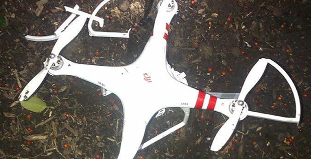
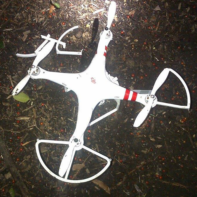
The quadcopter that crashed on the White House lawn. Photo: U.S. Secret Service
A government employee who crashed his friend’s drone on the White House lawn was apparently drinking while droning.
The employee, who works for the National Geospatial-Intelligence Agency (NGA), was questioned Jan. 26 by the Secret Service as the operator of the drone involved in Monday’s incident at the White House. On Monday at 3 a.m., the drone quadcopter crashed on the White House lawn.
The employee contacted authorities, according to the NGA. The employee was off duty and is not involved in work related to drones or unmanned aerial vehicles in any capacity at NGA, the agency said in a statement.
“Even though the employee was using a personal item while off duty, the agency takes the incident very seriously and remains committed to promoting public trust and transparency,” the statement reads.
The Secret Service is investigating the incident.
Firmware to Force No-Fly Zone Compliance
The drone is a Phantom made by Chinese company DJI. The company plans to roll out firmware within days to prevent any of its drones from flying over the D.C. area, in accordance with Federal Aviation Authority guidelines. This will help hobbyists who aren’t aware of or unable to comply with “no-fly zones,” such as the one that covers most of the D.C. area.
Once updated, the DJI drones will not be able to take off from or fly into the nation’s capital or a 15-mile radius around it. GPS technology in the drones will be able to identify the no-fly zone, warn the operator and then stop at the no-fly zone’s border. DJI’s flight software currently prevents flights within a radius of major airports.
“With the unmanned aerial systems community growing on a daily basis, we feel it is important to provide pilots additional tools to help them fly safely and responsibly,” said Michael Perry, DJI’s company spokesperson. “We will continue cooperating with regulators and lawmakers to ensure the skies stay safe and open for innovation.”
The mandatory firmware update is for the Phantom 2, Phantom 2 Vision, and Phantom 2 Vision+ models. It adds a No-Fly Zone centered on downtown Washington, D.C., extending for a 15.5-mile radius in all directions. Phantom pilots in this area will not be able to take off from or fly into this airspace.
“The restriction is part of a planned extension of DJI’s No Fly Zone system that prohibits flight near airports and other locations where flight is restricted by local authorities,” DJI said. “These extended no fly zones will include over 10,000 airports registered with the International Air Transport Association (IATA) and will expand no fly zones to ensure they cover the runways at major international airports.
“DJI is also continuing to update its no-fly zone list in compliance with local regulations to include additional sensitive locations and to prevent flight across national borders. These new safety features will be released across DJI’s flying platforms in the near future.”