The House Science, Space, and Technology Committee held a hearing Jan. 21 on the integration of commercial unmanned aerial vehicles in United States airspace. Colin Guinn, senior vice president of sales for 3D Robotics, demonstrated the Parrot Bebop drone during his testimony.
C-SPAN aired the event, as reported by the National Journal. Congress has tasked the Federal Aviation Administration with readying airspace for the integration of commercial drones. Drones are currently prohibited for use, but the FAA has granted a growing number of exemptions for certain industries, including an exemption to GNSS company Trimble for its UX5 drone.
Also, earlier this month, CNN signed a research agreement with regulators to test drone systems for news-gathering purposes.
CNN has entered into a Cooperative Research and Development Agreement (CRDA) with the Federal Aviation Administration to advance efforts to integrate unmanned aerial vehicles (UAVs) into newsgathering and reporting.
The cooperation arrangement will integrate efforts from CNN’s existing research partnership with the Georgia Tech Research Institute (GTRI). Coordination between and among CNN, GTRI and the FAA has already begun. The FAA will use data collected from this initiative to formulate a framework for various types of UAVs to be safely integrated into newsgathering operations.
“Our aim is to get beyond hobby-grade equipment and to establish what options are available and workable to produce high quality video journalism using various types of UAVs and camera setups,” said CNN Senior Vice President David Vigilante. “Our hope is that these efforts contribute to the development of a vibrant ecosystem where operators of various types and sizes can safely operate in the US airspace.”
“Unmanned aircraft offer news organizations significant opportunities,” said FAA Administrator Michael Huerta. “We hope this agreement with CNN and the work we are doing with other news organizations and associations will help safely integrate unmanned newsgathering technology and operating procedures into the National Airspace System.”
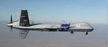
The CBP’s unmanned aerial program includes the Predator B aircraft, as well as ground control stations, pilots, sensor operators, video cameras, land and maritime radar, and communication equipment. (CBP Photo)
A new report by the Department of Homeland Security’s Inspector General’s office finds that use of unmanned aerial drones to patrol the U.S./Mexico border is not effective. The Customs and Border Protection’s (CBP) Unmanned Aircraft System program has been in operation for eight years.
Problems include a lack of performance measures and sky-high operational costs, according to the report, which was issued January 6. “Specifically, the unmanned aircraft are not meeting flight hour goals, and we found little or no evidence CBP has met its program expectations,” the report said. “We estimate it costs $12,255 per flight hour to operate the program; CBP’s calculation of $2,468 per flight hour does not include all operating costs.”
The $443 million CBP plans to spend on program expansion could be put to better use by using alternative technologies, the IG concluded.
The Hobbico ORA, a new drone system for aerial photographers, is being demonstrated at the 2015 International CES, running January 6-9 in Las Vegas. The camera-equipped drone displays captured aerial images on a seven-inch touchscreen integrated into the transceiver. With a 370-mm diameter and an onboard 1080p HD camera, the ORA also delivers high-quality images, reliability and long range through its recording method and choice of radio frequencies.
Designed for taking aerial views of action sports, outdoor weddings, real estate, vacation vistas and more, the ORA delivers out-of-the-box aerial photo and video capture with no need for radio-control piloting experience. All images are recorded on an SD card built into the drone, providing higher resolution than systems that use the transceiver for data capture, Hobbico said. Use of the 5.8-GHz radio band instead of the typical 2.-4GHz or Wi-Fi ensures a robust connection and a 500-meter flight control and video signal range.
The seven-inch first-person view touchscreen built into the ORA transceiver displays what the UAV’s onboard camera sees in real time, eliminating the need to use a cell phone, tablet or other third-party device to view captured images. Users can frame scenes exactly as they want them filmed by remotely controlling the camera gimbal. One-, two- and three-axis gimbal options are available, each designed also to accept GoPro cameras.
The transceiver has an integrated Android device for programming ORA functions through the touchscreen. A separate OLED telemetry screen displays flight data such as GPS coordinates, altitude and battery power status.
Other highlights include:
30 minutes of flight time per battery charge
Built-in GPS programming that puts flight routes, speed and altitude on auto-pilot
Support for 32 separate GPS waypoints to execute complex flight patterns
The ability to hold a steady altitude and position via GPS to film desired scenes
The option to save coordinates and fly the identical path again any number of times.
Selecting “Return to Home” brings the ORA back to its pilot with a single command. An “Actual Direction” option prevents control reversal confusion during manual flight — when activated, the quad always moves in the same direction as the control sticks. Additional failsafe systems watch for dangers such as low-battery power and automatically bring the ORA and camera home for safe landing.
The Hobbico ORA is scheduled for early 2015 release at an MSRP of $1,500-$2,000 depending on the battery, gimbal and camera configuration. The package will include the drone, 10-channel touchscreen transceiver, gimbal, batteries and charger.
The drone is on display at CES Booth #25214 in the Unmanned Systems Marketplace at the Las Vegas Convention Center’s South Hall 2.
HEXO+, an autonomous flying camera system, by Squadrone Systems will exhibit at CES 2015.
An Unmanned Systems Marketplace debuts this year at the annual International Consumer Electronics Show (CES), being held this week in Las Vegas. The marketplace highlights the burgeoning technology in drones, unmanned aerial vehicles (UAVs), and other unmanned systems controlled by onboard computers or remotely from the ground.
Also, a session on drones will focus on safety and privacy of commercial UAV use.
The Unmanned Systems Marketplace is at CES Tech East, in the Las Vegas Convention and World Trade Center (LVCC), South Hall 2. Tech East includes the LVCC, the Westgate Las Vegas , and Renaissance Las Vegas. Exhibitors at the marketplace include AirDog, Squadrone, Trace, DJI, iRobot, Trace, Torquing Group DBA ZANO, Ecovacs, EHang, Autel, Pelican Products, and other brands.
According to the CES description of the marketplace, “Drones, UAVs and other unmanned systems have taken off as a unique tool for everyday life, regardless of whether flight is controlled by onboard computers or remotely from the ground. Unmanned systems have revolutionized the way we capture, monitor and assist our world. They provide aerial coverage for sports, travel and real estate; enhance search and rescue, law enforcement and disaster relief; and so much more. Experience the variations in design and functionality of this technology with these current exhibitors in the all-new Unmanned Systems Marketplace.”
The session description reads, “The use of unmanned aerial vehicles (a.k.a. drones) for mapping, surveillance, newsgathering, filmmaking, and recreation is on the rise. Drone experts explore commercial and consumer market opportunities — including using drones to deliver packages — and address issues about safety and privacy.”
Zano is a portable aerial photography and video platform designed for consumers that measures 65 x 65 millimeters and weighs 55 grams. Torquing Group, who is developing Zano with the help of a successful Kickstarter campaign, said that Zano’s ability to fly autonomously will provide new possibilities for users seeking to capture images and videos. The drones can even be programmed to swarm.
What flies, takes selfies and fits in the palm of your hand? The tiny Zano drone.
Zano is a portable aerial photography and video platform designed for consumers that measures 65 x 65 millimeters and weighs 55 grams. Torquing Group, who is developing Zano with the help of a successful Kickstarter campaign, said that Zano’s ability to fly autonomously will provide new possibilities for users seeking to capture images and videos. The drones can even be programmed to swarm.
Zano’s location capabilities are powered by OriginGPS’ Nano Hornet, a tiny GPS module with an integrated antenna. Measuring just 10 x 10 x 3.44 millimeters, the Nano Hornet delivers performance and sensitivity with low power consumption. It achieves a rapid time to first fix of less than one second, with approximately one meter accuracy and -163 dBm tracking sensitivity. Because it detects changes in context, temperature, and satellite signals, it achieves a state of near continuous availability, while consuming mere microwatts of battery power.
The Zano connects directly with smart devices (iOS or Android) via onboard Wi-Fi to upload and share images or videos instantly. With the help of OriginGPS, Zano is able to know exactly where it is in relation to a smart device, even when powered off. Through a virtual tether, Zano will echo any movement made by the smart device it is synced to, with simple gesture control. A user will be able to control multiple Zanos from one device, enabling photographs and video of the same event from multiple vantage points.
Zano is also able to function in a “free flight” mode, which uses on-screen joysticks for an experience similar to a regular RC-operated UAV. OriginGPS’ location capabilities allow Zano to know if it is getting too far from its corresponding smart device and automatically return. Likewise, it is able to recognize its distance from the smart device and maintain that distance in “follow me” mode.
Since 2008, Torquing Group has developed small unmanned aerial vehicles (UAVs) for the military and defense industry.
To further push the boundaries of GPS modules designed to be small, agile and light weight, OriginGPS introduced the Nano Spiderintegrated GPS receiver in November. The Nano Spider module is designed to support ultra-compact applications where size is at a premium, such as smart watches, wearable devices, trackers and digital cameras. Like the Nano Hornet, it packs a wide range of functionality into its small form factor, including dual-stage LNA, RF LDO, SAW filter, TCXO, RTC crystal and RF shield with market-leading SiRFstarIV GPS SoC.
Amazon.com is warning the Federal Aviation Administration (FAA) that it will move its drone research abroad if it doesn’t get permission soon to test-fly in the United States, reports TheWall Street Journal. Amazon has already begun researching drone flights in the United Kingdom.
“Without the ability to test outdoors in the United States soon, we will have no choice but to divert even more of our [drone] research and development resources abroad,” wrote Amazon’s vice president of global public policy Paul Misener in a letter to the FAA, according to The Wall Street Journal. “I fear the FAA may be questioning the fundamental benefits of keeping [drone] technology innovation in the United States,” Misener wrote.
The FAA is required by U.S. Congress to frame a “safe integration” plan for the commercial use of UAS by Sept. 30, 2015. Changes in the law could restrict users of commercial UAVs by requiring licenses, with licenses issued to users only after many hours in the cockpit of a manned aircraft, comparable to traditional pilot licenses. The new rules would also limit flights to under 400 feet and within sight of the person at the controls, which is the current rule for hobbyists.
One of the FAA’s concerns is conflicts with manned aircraft. FAA data shows dozens of dangerous encounters around the country over the past six months, according to the Washington Post. Since June 1, commercial airlines, private pilots and air-traffic controllers have alerted the FAA to 25 episodes in which small drones came within a few seconds or a few feet of crashing into much larger aircraft. Many of the close calls occurred during takeoffs and landings at the nation’s busiest airports, presenting a new threat to aviation safety after decades of steady improvement in air travel.
Read one blogger’s account of a close call using a drone, partly caused by loss of the GPS signal.
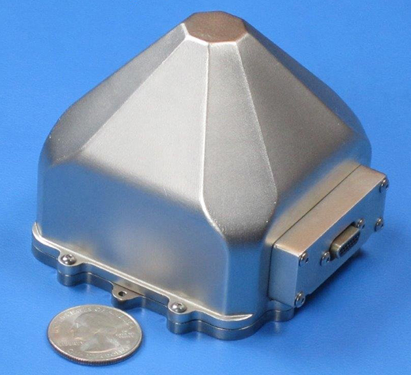
Sensors in Motion (SIM) has introduced a MEMS (micro-electro-mechanical) navigation-grade inertial system (INS) that it says could transform the $8 billion/year inertial market with new products by offering price and performance specifications better than those currently available.
The first INS devices have been delivered to the Army CERDEC Night Vision Electronic Sensors Directorate (NVESD).
SIM, a spinout from NASA’s Jet Propulsion Laboratory and California Institute of Technology, is developing a family of high-accuracy MEMS gyroscopes, accelerometers and inertial measurement unit ( IMU) solutions. It says it has perfected unique MEMS structures using volume silicon wafer processing techniques to produce gyroscopes having ARW (angle random walk) less than 0.0035 degree/root-hour and bias instability less than 0.01 degree/hour with extraordinary vibration and temperature immunity, a performance comparable to ring laser (RLG) and fiber optic (FOG) gyros that are 20 times larger and 100 times more expensive.
These features are mandatory for numerous applications where location is not available from GPS or vehicle position accuracy is required including autonomous vehicles, drones, mining asset tracking, dead reckoning, agricultural seed placement, oil and gas directional drilling, self-driving autos, firefighter navigation, optical image stabilization, industrial equipment azimuth, aerospace and defense products and most GPS-denied environments, in addition to new applications.
Current devices would have a vehicle position off as much as 1 foot per second at 45 miles per hour.
“We see this technology opening an additional $2B sensor market needing size, weight, power, cost and performance that does not exist today. “ said David Smukowski, CEO of SIM.
With adequate resources the company says further performance gains are possible, even while shrinking the devices smaller for better economics.
At InterGeo 2014, James Van Rens, chief executive officer of Riegl, explains the launch of the RiCopter UAV with LiDAR integration, and its designer gives a live demonstration of the UAV in flight. The show was held October 7-9 in Berlin.
The unmanned aerial vehicle is a survey-grade unmanned scanning platform for a variety of demanding applications, such as corridor, power line, or railway mapping.
The high-performance UAV can be equipped with the Riegl VUX-1 survey-grade LiDAR sensor to offer a fully integrated turnkey solution. The RiCopter platform design includes a fully integrated Riegl VUX LiDAR sensor, IMU/ GNSS unit with antenna, control unit, and up to four optional cameras providing measuring characteristics of a 330-degree field of view, 500,000 measurements per second, and 10-millimeter accuracy.
The class 1 unmanned aircraft system can be flown at a maximum operating altitude of 550 meters with a maximum take-off mass of up to 25 kg and a maximum payload of 16 kg, providing a long flight endurance of 30 minutes.
RiCopter flight characteristics are smooth and stable in hovering positions, as well as on demanding flight maneuvers under challenging conditions.
HEXO+, an autonomous flying camera system, by Squadrone Systems will exhibit at CES 2015. Photo: Squadrone Systems
The Consumer Electronics Association today announced the debut of the Unmanned Systems Marketplace at the 2015 International Consumer Electronics Show (CES). Owned and produced by CEA, the International CES is a gathering place for those who thrive on the business of consumer technologies. The 2015 CES is scheduled to run January 6-9, 2015, in Las Vegas, Nevada.
The Unmanned Systems Marketplace highlights the burgeoning technology in drones, unmanned aerial vehicles (UAVs), and other unmanned systems controlled by onboard computers or remotely from the ground. In its first year at the CES, the Unmanned Systems Marketplace is expected to cover 6,500 square feet of exhibit space with room for about 16 high-end commercial and consumer UAV technology companies.
According to CEA research, the global market for consumer drones will approach $130 million in revenue in 2015, increasing by 55 percent from 2014, with unit sales of consumer drones expected to reach 400,000. The revenue from drone sales is expected to easily exceed $1 billion in just five years.
“Drones and unmanned systems are being used to assist in a variety of applications, from aerial coverage for sports and real estate, to assistance in search and rescue and disaster relief missions,” said Karen Chupka, senior vice president, International CES and corporate business strategy, CEA. “We’re excited to introduce the Unmanned Systems Marketplace at the 2015 CES and witness how these unique tools are revolutionizing the way we capture and monitor our world.”
The Unmanned Systems Marketplace will be located at CES Tech East, in the Las Vegas Convention and World Trade Center (LVCC), South Hall 2. Tech East includes the LVCC, the Westgate Las Vegas , and Renaissance Las Vegas. Major exhibitors located within the Unmanned Systems Marketplace include AirDog, Squadrone, Trace, DJI, iRobot, Trace, Torquing Group DBA ZANO, Ecovacs, EHang, Autel, Pelican Products, and other brands.
The 2015 CES will feature 20 category-specific marketplaces highlighting innovation across diverse product areas. Companies interested in exhibiting in the Unmanned Systems Marketplace should contact Oleg Burdo at [email protected] or 703-907-5257.
Registration for the 2015 CES is open. For more information on the 2015 CES, visit CESweb.org.
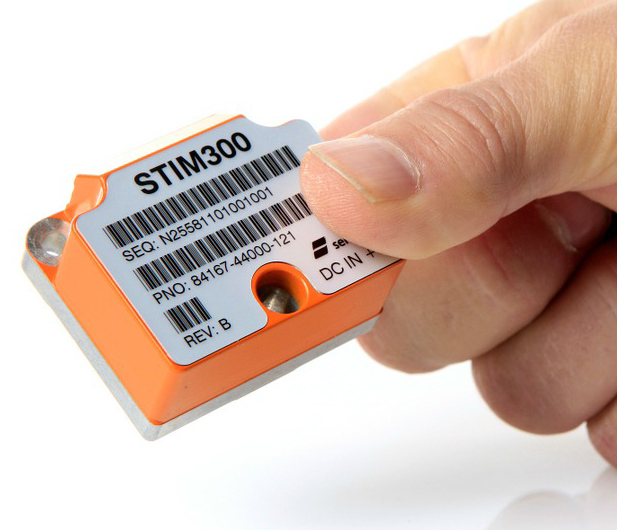
The STIM300 is a small, tactical-grade, low-weight, high-performance non-GPS aided IMU. It contains three highly accurate MEMS gyros, three high-stability accelerometers and three inclinometers. The IMU is factory calibrated and compensated over its temperature operating range.
The STIM series is designed for use below and on the ocean, on land, in the air, and in orbit and space. The STIM300 IMU is well suited for stabilization, guidance and navigation applications in the industrial, aerospace and defense markets. It is a crucial building block for inertial navigation systems in UAVs, AUVs, AGVs, UGVs and ROVs, Sensonor said.
The STIM300 is also used for camera turret stabilization and for use in various handheld devices that require a small IMU to secure operations during GPS outage.