The West Virginia Department of Transportation (WVDOT) turned to UAVs to save time and money. Incorporating drones has saved WVDOT more than $340,000 in a single month.
In 2017, WVDOT began formally looking into launching a drone program. WVDOT concluded that drones could be ideal for stockpile surveys — using them had the potential to speed up the process, reduce risk, and increase accuracy.
Jesse Bennett, statewide survey unit leader at WVDOT, flew several test missions to validate the use case. He quickly realized drones had huge potential to transform this time-consuming and risky task.
The agency began with a team of nine Federal Aviation Administration-certified drone pilots and 12 drones. WVDOT also began using Skyward’s Drone Management Platform to manage their flights, pilots and equipment. Skyward offered a single, digital platform to coordinate complex missions and obtain airspace permissions.
“I saw the need for something like Skyward from the very beginning, when I was the first and only pilot,” Bennett said. “I was manually making entries in flight logs and maintenance logs, and I was using about seven or eight different apps and websites just to plan and fly a mission.”
Using Skyward as a single place to keep track of every aspect of the drone program enabled Bennett to quickly resolve an investigation after someone mistakenly assumed he didn’t have authorization to fly in an area and reported him to the FAA.The software helped him demonstrate that crews were obeying FAA regulations and WVDOT’s own rules.
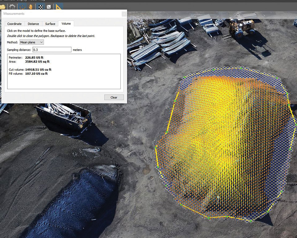
Starting in spring 2019, WVDOT began deploying drone crews for stockpile inspections at scale. WVDOT has 177 sites across the state that contain stockpiled materials. Each year, the stockpiles must be physically surveyed to calculate the volume of material. From 42 surveyors laboring for 15 workdays, the same workload took seven UAS pilots only nine workdays to complete the project.
With a very good PNT device already installed for flying the aircraft, why not just tap into that one for the payload, right? This might not be a good idea, for several reasons.
By John Fischer Vice president, Advanced R&D, Orolia
John Fischer. (Photo: Orolia)
The navigation device in a UAV is very important, precisely because there is no pilot. It must navigate autonomously. It must also be optimally suited for the airframe, either fixed or rotary wing, providing the accuracy and reliability for all modes of flight, from takeoff to landing. A lot of engineering goes into the design and certification of each UAV’s navigation system to qualify it for flight.
UAVs can have multiple missions with interchangeable payloads: cameras for observation and inspection; communication equipment for relaying links or supplying emergency cellular base stations; or sensing equipment such as radar, lidar, spectrometers, etc. These payloads also need positioning, navigation and timing (PNT) sources for their missions, for example, to accurately geo-timestamp the collected data.
With a very good PNT device already installed for flying the aircraft, why not just tap into that one for the payload, right? Actually, this might not be a good idea, for several reasons.
Recertification. Modifying the navigation device, which is part of the flight control system, risks having to re-certify the aircraft for flight safety. Though a UAV has less severe restrictions on safety than a manned aircraft, it can still cause property damage or even injury and loss of life if it crashes in a populated area. The Federal Aviation Administration has numerous standards — DO-178 for software, DO-254 for hardware, DO-160 for testing — to ensure avionics are designed and tested for safe operation. Every modification, regardless of how small, must follow these standards and may require expensive re-certification of the aircraft’s airworthiness.
Performance Requirements. These vary with each mission. The flight control system includes a navigation device that was selected based on the aircraft’s special requirements. These will not necessarily match the needs of the payload. For example, consider pitch, roll, and yaw sensing accuracy. The accuracy required to determine the pointing angle of a camera might not be the same as what is needed for level flight.
Interchangeability. A particular UAV can have multiple payloads for different missions. Conversely, a particular mission payload can be adapted and installed on several different UAVs. Having a second PNT device matched to the payload allows it to stay with the payload as it is moved to different UAVs. This can lower the total cost of ownership and operation, since the extra cost of a second device is small compared to the adaption work and design changes necessary to make a single PNT device be suitable for all situations.
Missing the T in PNT. Typically, the navigation device for flying the aircraft doesn’t have a precise internal oscillator for supplying time and/or frequency — it doesn’t need it. However, most payloads can benefit from the time/frequency component to enhance mission performance. A low phase noise oscillator with low g-sensitivity that is disciplined by the precise time supplied by a GNSS receiver can substantially improve the performance of any payload radar or communication system.
A second device does not impact SWAP or cost significantly — GNSS receivers and inertial navigation systems are no longer large, expensive items. A second PNT device is typically small, weighing less than a kilogram and consuming only a few watts of power. There are also fewer connectors and cable harnesses when a removable payload is not sharing the aircraft’s PNT data, so the weight differential might be zero. PNT devices can share antennas on the aircraft via splitters, so there is no need to place additional antennas.
Technology upgrades. Micro-electromechanical systems (MEMS), inertial sensors, cameras, lidars, radars and other sensors are all evolving at a rapid pace with better technology available with each passing year. Flight control systems evolve at a different pace — mostly because of the flight certification process, but also for lack of a driving need. UAVs navigate just fine with the equipment they have today. A separate payload PNT device allows the system designer to keep pace with evolving technology, choosing the latest and best for the mission without disrupting the navigation system.
Just as “two heads are better than one” for problem solving, having two PNT devices in a UAV is often the better solution.
John Fischer is vice president, Advanced R&D, Orolia, and a member of GPS World’s Editorial Advisory Board.
Zala Aero Group unveiled the ZX1, a new hybrid unmanned aerial vehicle (UAV), at the 2021 International Defense Industry Exhibition (IDEX) and Conference, which opened on Feb. 21 in Abu Dhabi.
The new drone has vertical-takeoff-and-landing (VTOL). According to Zala, it combines the best qualities of fixed-wing and multirotor types of UAVs; its configuration can change depending on the conditions of the performed task.
Ease of operation allows the UAV system to reduce the operator’s role, decrease the amount of equipment used when performing a flight mission, and fully automate flight processes of the UAV.
The ZX1’s onboard computer uses artificial intelligence, which makes it possible to process data in full high-definition, and transmit HD video and photos via encrypted communication channels to the GCS, ensuring the effectiveness of monitoring even before the aircraft lands.
The VTOL design makes it compatible with existing ZALA payloads, and also allows the installation of additional surveying equipment. It can be used to perform air monitoring for the fuel and energy sector and search-and-rescue operations from sites in urban environments.
Zala Aero Group, founded in 2004, is a Russian developer and manufacturer of unmanned aerial systems, payloads and mobile systems. It is now part of Concern Kalashnikov. Its main products are reconnaissance unmanned systems and digital solutions. Currently, more than 2,000 of Zala UAS operate within Russia. Areas of application are the protection of state borders, reconnaissance and rescue operations, monitoring of high-risk facilities and emergencies.
Auterion, an open-source drone software platform provider, has partnered with C2 Group — a program, project and construction management firm — to power the use of drones for inspection, mapping and disaster response across the utilities and critical infrastructure industries.
The collaboration has been formed after C2 Group conducted extensive testing of the Vantage Robotics Vesper drone powered by Auterion to inspect power lines at its UAS testing ground and assess viability within the utilities space.
Auterion and C2 Group have seen a shift in the utility industry to move away from drones manufactured overseas to focus on the adoption of U.S.-made products such as the Vesper, a Blue sUAS-certified product used by the U.S. military.
Features on the Vesper that the utilities industry can use include high-quality sensors and thermal capabilities, while its stability and lightweight design make it rapidly deployable.
Utilizing the data security, quality and flexibility enabled by Auterion across multiple UAS manufacturers means C2 Group pilots can be trained on one flight platform but fly any drone associated with it; reducing the training time and increasing overall productivity. Further productivity measures are achieved with Auterion’s Suite used to identify pilot efficiencies and its Simulator to augment pilot training. At the same time C2, with its industry knowledge having worked with multiple major utilities in the US, is providing insight that is helping to shape Auterion’s roadmap for new sensors and airframes into the future.
Brandon Del Priore, CTO at C2 Group, said: “We are proud to partner with Auterion to bring some of the best technology developed in the US to our clients in the utilities and critical infrastructure industries. When safety, data security, and data quality matter most, C2 Group will be there to offer customers the same US-made hardware and software used by the DoD’s Defense Innovation Unit and the US military. The open source ecosystem is helping to drive a better footprint within the marketplace and a better level of compatibility for US made products.”
Cynthia Huang, VP Enterprise Business Development at Auterion, said: “With DJI added to the entity list, we’re seeing enterprise drone operators accelerate their search for alternatives. Auterion’s open source software ecosystem provides more options, more solutions, and faster development timelines to the needs being identified today and companies are embracing the power of our approach. We are excited to partner with C2 Group to bring US made solutions and the advantages of open source to their customers.”
For more information, visit www.auterion.com/enterprise
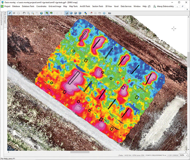
SPH Engineering has launched a drone-integrated metal detection system with a Geonics EM61Lite metal detector, a new product of UgCS Industrial Solutions. The same performance and robustness available for users of the standard EM61-MK2 time domain metal detector are now available for airborne use.
The new system is capable of detecting metallic (magnetic and non-magnetic) items in the first few meters under the surface, finding metallic objects in hard-to-reach or dangerous areas.
Applications include unexploded ordnance (UXO) search, detection of underground infrastructure and archaeology. The integrated system has been extensively tested at SPH Engineering’s test range, and has shown excellent performance and repeatability for targets such as pipes (steel, stainless steel, reinforced concrete) and steel drums.
The system uses an airborne (less heavy) modification of the Geonics EM61-MK2 ground metal detector. The EM61 Lite airborne variant integrates with the UgCS SkyHub onboard computer and ground control station.
Features include automatic data logging in geotagged form and automatic terrain following with radar altimeter. The use of UgCS SkyHub enables the drone to fly in true terrain following (TTF) mode with the help of the radar altimeter and to log geotagged sensor data.
An optional RTK/PPK GNSS receiver on the drone will geotag the data with centimeter-level precision.
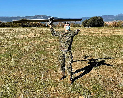
The Spanish Army and Navy have received the first Seeker Remotely Piloted Aircraft Systems (RPAS) from GMV and Aurea Avionics. The unmanned aircraft is designed to boost the intelligence, surveillance and reconnaissance capabilities of two elite forces, the Spanish Army’s 6th Almogávares Paratroopers Brigade and the Marine Infantry Protection Force.
Seeker has a 90-minute endurance and 15-km range, and weighs 3.5 kg. The UAV’s design and manufacture in Spain proved crucial during the COVID-19 epidemic, with the manufacture, test flights and delivery of the aircraft all performed within the project deadlines.
In the final phase of the project, intensive training courses took place on the Madrid site of Aurea Avionics and the Los Alijares Firing and Maneuvering Range (CMT) of Toledo. There, future Seeker users put the RPAS through its paces with mission simulations, engaged in vehicle-tracking exercises and learned about its theoretical and practical uses.
Seeker will provide BRIPAC (Paratrooper Brigade) and BRIMAR (Marine Infantry Brigade) with real-time thermal-infrared and visible-spectrum video, augmented by metadata that can be mined by the operators and remotely by the command-and-control centers.
New digitized ground-station architecture makes Seeker compatible with NATO’s standard command centers. This means any allied force will be able to integrate the aircraft into its fleet and command centers, ensuring joint operability between all troops and systems.
The RPAS is financed by the Subdirectorate General of Planning, Technology and Innovation of the Directorate General of Armaments and Material.
Esri is offering two major capabilities in Site Scan for ArcGIS that will enable governments and critical infrastructure organizations to meet hardware and software regulations in the United States and Europe. Site Scan is Esri’s unmanned aerial systems flight planning and processing solution.
Through an established partnership with Auterion, creator of an open-source drone autopilot operating system, security-conscious U.S. organizations will be able to use Site Scan to plan and execute missions with Auterion’s Freefly Astro drone.
In Europe, data from publicly funded or critical infrastructure projects cannot leave the European Union (EU). For these organizations, a new and fully independent instance of Site Scan for ArcGIS has been deployed to a server cluster in Ireland, ensuring that organizational data resides within the region.
Site Scan for ArcGIS is used by organizations that require drone imagery for visual inspections, site monitoring, asset management and situational awareness. It’s an all-in-one, cloud-based drone mapping solution for managing fleets and collecting, processing, analyzing, and sharing data products. Industries using this solution include architecture, engineering, construction, natural resources, infrastructure and government.
Freefly Astro uses U.S. Department of Defense-approved Blue sUAS software architecture from Auterion, and is fully supported by Site Scan. The first vehicle integrates the software with the Freefly Astro, with more vehicles becoming available.
Auterion’s secure, integrated workflow for mapping uses the Freefly Astro drone, Sony A7R4 camera and Esri Site Scan within a single platform.
The Freefly Astro and Site Scan integration will be available by December. The European deployment of Site Scan is available now.
A solution for these COVID-19 days, getting to injured people really fast, and potentially even faster first response applications are all new drone applications featured in this month’s UAV summary.
As people welcome back football this fall — although playing in empty stadiums – most people are staying home to watch the game on TV. Even though some sports teams like the MLB Dodgers resorted to cardboard cut-outs of fans, maybe to encourage players, nothing beats having real people stamping and cheering in the stands.
So its not surprising that when the Atlanta Falcons play the Carolina Panthers this month at Atlanta’s Mercedes-Benz Stadium, they are planning on having a limited number of real live fans at the game to cheer on the teams. Even in these pandemic days of social distancing and masks, it would seem that a reduced number of fans might space out well in the huge 71,000 seat capacity stadium.
But the drone angle comes with the clean-up afterwards — 71,000 seats, handrails and partitions take a lot of manual wiping down – so the Atlanta Falcons are bringing on disinfecting drones to do the job, potentially with only 5% of the effort it normally takes.
There are two D1 drones being used in Atlanta supplied by Lucid, each equipped with a 2.5-gallon tank filled with nontoxic disinfecting chemicals. The sanitation solution is distributed by specially designed ‘electrostatic nozzles’ which spray evenly and mist the area as the drone passes over.
Disinfecting drones have been used before in places which include several locations in China, the city of Dubai, and company EagleHawk in New York offers drone sanitizing for stadiums and other large public facilities. If this approach works we’ll probably see it in many more stadiums in an effort to safely bring back the fans.
Not sure how this next item fits into the unmanned category for this month’s article — because its certainly manned. But what the heck, its certainly interesting and worth a whirl.
Jet packs have been around for a while, but the U.K. company Gravity has come up with a configuration that appears to be reliable and works well. They recently pitched their system for search and rescue in the Lake District — a mountainous area in the North West of England which is extremely popular for hiking, walking and climbing. So visitors will sometimes get hurt falling off a ledge or a high path on the side of a mountain, or just tripping while walking and injuring an ankle, leg or knee. The rocky hilltops, mountains and many lakes of the Lake District attract around 15 million visitors each year, so there is plenty of opportunity for injuries.
With five miniature jet engines and carrying around 35 liters of jet fuel, the Gravity system range/endurance isn’t that great, but boy is it quick if you want to run up the side of a mountain to find an injured hiker. So more rapid response rather than search — provided you already know where the person is located.
The system is powered by a double jet-engine held at the end of each arm and a single engine with equivalent thrust housed in the actual backpack. Altogether, over a 1000 horse power, which is apparently enough to pick a person up and keep them suspended at around 10 feet off the ground. Guess you would need quite some strength to hold onto the arm units, supporting one-third of your weight on each arm, but apparently you get some level of stability assistance from a flight control system in the backpack.
A recent demonstration test in the Lake District with the Great North Air Ambulance Service certainly showed off the suit’s capability to go from the foot of a mountain up to near the crest of the hill in no time flat. Then a regular air-rescue helicopter was immediately called in to take the victim to hospital. However, the current system apparently costs somewhere around $400,000, so its doubtful it will show up for anything but special appearances and demos until there has been significant engineering cost reduction.
The “Recruit” hi-speed drone is aimed at rapid first response users (Photo: Sonin)
Sonin Hybrid has taken another angle to building a drone by developing a hybrid gas powered propulsion system which charges the vehicle’s batteries while in flight, uses a lightweight carbon-fiber frame with folding landing-legs, and is able to fly at up to 140 mph when pressed to do so. Nominal cruise flight is at 60mph, and flight endurance is claimed to be up to 3 hours – over 5 times that of similar competitor drones.
The Recruit’s options include a stabilized 4k camera, a night vision/IR camera, 30x optical/12x digital zoom camera, a 6k lumen spotlight and a loudspeaker/siren.
With several trials currently underway with first responders, Sonin is eager to establish the requirements for police, fire and military applications. Let’s hope that the trials all involve getting eyes on a location as quickly as possible so hi-speed drone capabilities are needed. Otherwise all the drone racers will probably scoop up these 140mph puppies.
So to enable people to perhaps return to watching sports in person during the ongoing pandemic we have drones pumping disinfecting spray all over sports stadiums which can potentially save huge amounts of manual cleaning effort, provided they can adequately sanitize the target areas — specialized spray nozzles help. Then we have a jet-pack system which was demonstrated getting to injured people as quickly as possible to administer immediate care, followed up by helicopter air rescue. And finally if you want a hi-speed, lightweight drone with good payload capability, Sonin has launched the 140mph Recruit aimed at first responders who need a very quick first response.
These are all completely different applications, all with completely different solutions.
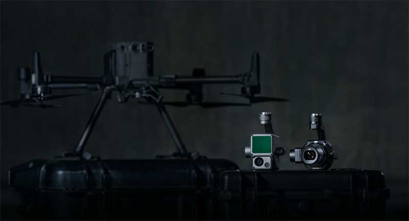
DJI unveiled two new solutions at Intergeo 2020: the DJI Zenmuse L1 lidar solution for aerial surveying and DJI Zenmuse P1 camera payload. (Photo: DJI)
DJI has debuted two payload solutions for its flagship commercial drone platform Matrice 300 RTK: the DJI Zenmuse L1 and DJI Zenmuse P1. The solutions were unveiled at Intergeo 2020.
DJI Zenmuse L1
The Zenmuse L1 is DJI’s first lidar solution for aerial surveying. DJI Zenmuse P1 integrates a Livox lidar module with a 70-degree FOV, a high-accuracy IMU, and a 20-megapixel camera with a 1-inch CMOS sensor and a mechanical shutter on a 3-axis stabilized gimbal.
According to DJI, the Zenmuse L1, which has a point rate of 240.000 points per second and a detection range of 450 meters, can generate true-color point cloud models in real-time, or acquire a vast area (up to 2 km2) of point cloud data in a single flight. The module supports both line scan mode and non-repetitive scanning mode.
When used with DJI’s flagship commercial drone platform Matrice 300 RTK and DJI Terra surveying software, it becomes a complete and versatile solution that gives the user real-time 3D data throughout the day, efficiently capturing the details of complex structures and delivering highly accurate reconstructed models, DJI said.
DJI Zenmuse P1
The DJI Zenmuse P1 camera payload integrates a 45-megapixel full-frame low-noise high-sensitivity sensor offering flexible viewing with interchangeable 24/35/50mm fixed-focus lenses on a 3-axis stabilized gimbal.
According to DJI, the Zenmuse P1 is equipped with a TimeSync 2.0 system, which synchronizes time across modules at the microsecond level. It features a smart oblique camera feature that helps improve efficiency by only capturing the photos essential to the reconstruction at the edge of the mapping areas. DJI Zenmuse P1 also integrates a 45-megapixel full-frame low-noise high-sensitivity sensor.
“With these two new payloads, we are providing an all-integrated complete solution to our enterprise customers active in accurate geospatial data acquisition,” said Arjun Menon, engineering manager at DJI in the U.S. “Having a fully integrated capable and affordable lidar seamlessly integrated into our best commercial drone is a dream that becomes reality for surveying, mapping and construction professionals. They will be able to see, cover and understand the geospatial context from a totally new perspective thanks to the high level of accuracy and quality of the data collected from these tools in the sky.”
Walmart is teaming up with drone delivery company Zipline to launch a drone delivery operation in the United States. According to Walmart, this first-of-its-kind drone delivery service will make on-demand deliveries of select health and wellness products with the potential to expand to general merchandise.
Trial deliveries will take place near Walmart’s headquarters in Northwest Arkansas. The trials will use Zipline’s proprietary technology.
Zipline will operate from a Walmart store and can service a 50-mile radius, Walmart said. The company’s launch-and-release system allows for quick on-demand deliveries in under an hour, and it also eliminates carbon emissions, Walmart added.
Zipline began operating in 2016 in Rwanda, primarily focusing on the on-demand delivery of medical supplies. According to Zipline, it has safely delivered more than 200,000 critical medical products to thousands of health facilities serving more than 20 million people across multiple countries.
The operation will likely begin in early 2021, Walmart said.
The U.S. Federal Aviation Administration (FAA) has made it easier for drone pilots to quickly and safely access controlled airspace by adding 133 air traffic facilities to the Low Altitude Authorization and Notification Capability (LAANC) system. The expansion is based on feedback from the drone community.
LAANC is an automated application and approval system for drone pilots requesting to fly below 400 feet in controlled airspace.
As the FAA continues to modernize the national airspace to accommodate more users, the agency made LAANC accessible for 726 airports and 537 facilities, covering 81% of eligible airspace.
LAANC is a collaboration between the FAA and the unmanned aircraft systems (UAS) industry which directly supports the safe integration of drones into the nation’s airspace. The service is accessible to all pilots who operate under the FAA’s small drone rule.
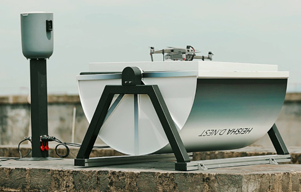
Heisha, a drone-charging solution and unattended drone system provider, has launched a new drone-in-the-box hardware platform, D.NEST.
D.NEST is an automatic drone-in-the-box hardware platform compatible with DJI drones, open-source project drones and vertical take-off and landing (VTOL) aircraft.
Based on Heisha’s third-generation charging pad C500, D.NEST is a reliable and stable automatic drone charging solution. Equipped with a built-in AI computer, remote-control base and local router, D.NEST is easy to maintain and redevelop, according to the company. Additionally, the hardware platform can be a data center and control center for different robots.
Heisha operates an open-source interface API and SDK, making it flexible. Designed for use with the DJI Mavic and Phantom series, D.NEST can also be customized for use with the M200, M210, M300, M600, open-source UAVs and VTOL fixed-wing UAVs.
Equipped with the 5-in-1 PCB control K100 and industrial-level materials, Heisha also provides a useful, stable and cost-effective drone-charging platform.