Drones are quickly becoming a staple of the maritime industry. In January, the European Maritime Safety Agency (EMSA) issued the largest ever civilian maritime drone contact, valued at €67 million.
Under the contract, drones will be used to assist with border control, search-and-rescue operations and monitoring of pollution, as well as the detection of illegal fishing and drug and people trafficking.
External Vessel Inspections. Big names in the maritime industry such as DNV-GL, Lloyds Register and Maersk have all shown strategic intent to revolutionize their operations by embracing drone technology, and many maritime operators are now following suit.
All ship owners know that traditional methods of external vessel inspection can be a costly affair. Now that high-definition, camera-equipped drones are widely available and affordable, it is becoming more common to use them for external vessel inspections to assess structural conditions. Identifying substantial corrosion, significant deformation, fractures, damage or other structural deterioration can be done quickly, easily and cost-effectively using drones.
Tank Inspections. The visual inspection of cargo tanks was traditionally performed by workers suspended on ropes to inspect the tank structure. The sheer size of modern-day vessels means that access methods including staging, rafting and climbing are often used by surveyors to access tanks.
In contrast, drone surveys require no human access to the tank and, since no access equipment is required, there are no setup costs, and inspections can be completed within a quicker timeframe.
Martek Marine’s V-200 UAS. (Photo: Martek Marine)
Bathymetric Surveys. Accurate and reliable information on the features of water bodies and their shorelines is vital to navigational safety. Bathymetric surveys gather the information, which is then published for use on nautical charts. Rather than using a fixed-wing airplane or helicopter, bathymetric sensors developed for drones allow this type of survey to be carried out flexibly and at a fraction of the cost.
To operate effectively in the harsh maritime environment, the technology has been developed to withstand storm force wind and heavy rain, snow and salt spray.
As technology advances, so does the flight time available on drones, meaning more area can be covered in a quicker timeframe.
Floating Flare-Tip Inspections. Drone surveys typically exist to provide close visual and thermal inspections of high, live or difficult to access structures offshore, and there’s nothing more challenging to access than a flare tip, 70 meters above water, on a floating production facility.
Drone survey inspections for flare tips remove the need for a shutdown to inspect the flare and offer reduced costs compared to aerial surveys carried out by helicopter or plane.
Offshore Wind Energy. The wind energy sector is growing fast. Storm force winds, erosion, lightning strikes and even build-up of insects can have an impact on turbines, and blades need to be inspected for deterioration. Inspectors have traditionally had to scale the turbines with the help of ropes and cables.
The maritime surveying company Martek Marine uses a drone fleet designed for turbine-blade inspections onshore or offshore. Qualified and trained pilots quickly and accurately identify and assess faults.
Traditional surveying requires turbines to be offline for two hours up to a day, but Martek’s inspection process reduces this time to 45 minutes.
Following the inspection, the client can access the data through Martek’s secure, cloud-based asset management portal where they can download a detailed PDF report and access raw survey data.
Fully Autonomous Drones? Fully autonomous drones could be the next big thing for maritime surveying. The drones can be pre-loaded with a 3D model of the ship. This allows the drone to autonomously work its way around the vessel, stopping at points of interest to obtain detailed video or image data.
Advancing this further, a drone could be designed to create its own 3D map of the vessel before carrying out the survey independently.
This article is excerpted from a blog by Martek Marine, a UK-based maritime surveying company. Read the full blog, with more details and examples.
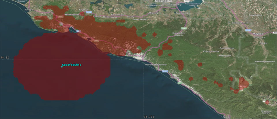
We’ve heard a lot in the news recently about GPS spoofing, mostly centred on the story of ship spoofing in the Black Sea. Between June 22-24, a number of ships in the Black Sea reported anomalies with their GPS-derived position, and found themselves apparently located at an airport.
What happened is open to educated conjecture. In this column, I’ll briefly cover the history of spoofing, its basic techniques, some spoofing tests that we conducted, and then return to the infamous Black Sea incident.
As part of my day-to-day work in navigation warfare, I do a fair amount of work in defensive anti-spoofing. Naturally, in order to test anti-spoof technology, it is necessary to also perform spoofing. It’s a delicate subject and, as with any topic involving defense or national security or critical infrastructure, there’s a balance to strike between responsible disclosure, how much information is released into the public domain, and so on.
In this article, I will stick firmly to information available in the public domain, lest I be accused of proliferating the threat, but this still gives us enough material to tiptoe around the subject for the benefit of our readers. I could have included more details about the spoofing attacks, but was advised to hold some back — it makes governments nervous. You can read some of the background in an excellent article by Norwegian broadcaster NRK and a Resilient Navigation and Timing Foundation press release. Similar GPS anomalies still continue to occur at various locations.
Let’s start with basic spoofing background, and we’ll return to the Black Sea incident at the end of the article.
A brief history of spoofing
Spoofing isn’t a new threat — it’s been around for decades. But only in recent years has it received so much public attention. As with jamming and anti-jamming technology, and most other topics in the GPS domain, spoofing finds its roots back in the days of Cold War radar. In those times, it was often known as “deception jamming,” where you would transmit fake radar returns to paint an incorrect picture on your adversary’s radar screen.
When GPS came along, it was understood at the time that the C/A code would be vulnerable to spoofing. It’s an open code, so anyone is free to reproduce it. That is, after all, what a GPS simulator is: a GPS spoofer. We legitimately test our GPS receivers by fooling them with fake signals from a GPS simulator.
Of course, this is precisely why legacy GPS satellites also transmit the military P(Y)-code, and continue to do so. The P-code offers improved accuracy, and some other benefits, but more importantly, it is modulated with the W encryption sequence to give us the encrypted P(Y)-code. Ever since the anti-spoofing module was set to the “on” state, unless you have the key, you are unable to directly spoof the P(Y)-code. (You can still perform a meaconing attack, though, where you simply record the transmitted satellite signals and retransmit them again. Although this kind of attack can’t be used to impose a particular scenario on a GPS receiver, it might still cause havoc in unwary receivers).
So. in the early days it can be argued that the spoofing threat was solved. It wasn’t until GPS became ubiquitous in the commercial and civilian domain that spoofing really raised its head again. The fact that the vast majority of GPS receivers in the world relied solely on the unencrypted C/A code became a cause for concern — especially where those GPS receivers were essential to critical infrastructure.
The threat of GPS spoofing was discussed at many conferences and behind many closed doors and, although most people agreed that spoofing was a theoretical threat, some people argued that in reality it was “simply too hard” to conduct a realistic spoofing attack. And therefore we should not worry ourselves about it.
It wasn’t until a couple of high-profile demonstrations were carried out by the University of Texas Radionavigation Laboratory that spoofing became front-page news once again. In 2012, the lab staff carried out an exercise at White Sands Missile Range where a GPS-guided drone was spoofed from a distance. The drone was fooled into thinking its altitude was increasing, causing it to compensate by dropping straight down. Then in 2013, the same team demonstrated how an $80 million yacht could be steered off course by means of a spoofing attack.
These exercises publicly demonstrated that spoofing was indeed a real threat, and could be done. But many people still believed that it was very hard to build the complex equipment necessary to perform the attack, and thus spoofing was out of reach for most potential criminals or terrorists.
Fast forward another two or three years, to when a new mobile phone game appeared. Pokemon GO became the game craze of the moment, where players would travel around the country with their phones, getting points by collecting creatures in an augmented reality world. It didn’t take long for people to dream up new ways of earning points in the game, without having to go to the effort of traveling around the world.
What if you could make your phone think it was somewhere else, without ever having to leave your bedroom? And thus, bizarrely, it was a mobile phone game that brought GPS spoofing into the mainstream.
The rise of the low-cost software-defined radio (SDR) has enabled “spoofing for everyone.” Today, the tool of choice for the casual user is often the HackRF or bladeRF. Couple small SDRs that cost around $200 with open-source GPS simulation software, and you have a basic spoofer. Plenty of websites detail how to perform basic spoofing, and at hacker gatherings, people can present how they spoofed a drone. These may not be the most sophisticated setups, but it’s good enough to do the job in many cases. With a better setup, which I won’t describe here, it’s possible to achieve a much more realistic attack, which will fool even the most shrewd and wary GPS receivers.
Spoofing basics
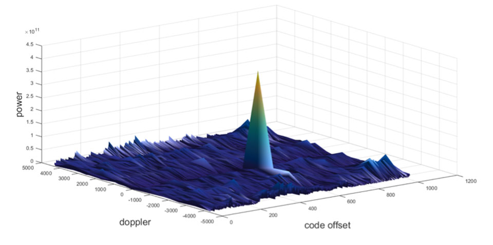
Let’s take a quick look at what it means to spoof GPS. A receiver searches for a satellite over a two-dimensional surface to find a correlation peak, and it must examine a range of Doppler frequencies and code offsets. An example is shown in Figure 1. Once the receiver finds the peak, the satellite is acquired, and it will then track the satellite as it moves and can demodulate the navigation data message.
When a spoofer comes along, it tries to recreate this peak. By doing so, and usually with little more power than the real satellites, the receiver will begin to track the spoofed signal. Once the spoofed signal is being tracked, the spoofer can begin to manipulate reality by slowly modifying the properties of the signal.
Figure 1. GPS correlation surface. (Image: Michael Jones)
A poor spoofer doesn’t always align itself very well with reality, which essentially creates a second peak on the correlation surface. But a gullible receiver can still be fooled by this, and may lock on to false peaks.
The reality of spoofing and anti-spoofing
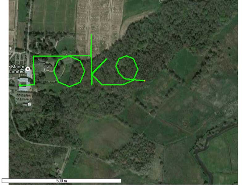
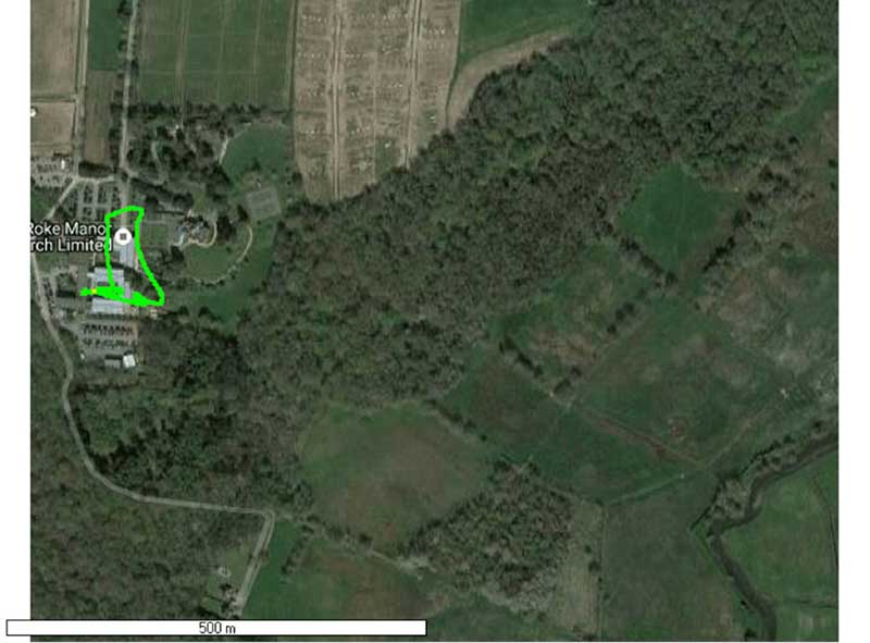
To understand the reality of spoofing and anti-spoofing, we carried out outdoor experiments at one of the Roke Manor trials areas (thanks go to my colleague Mike Wells for letting me use some of his results here).
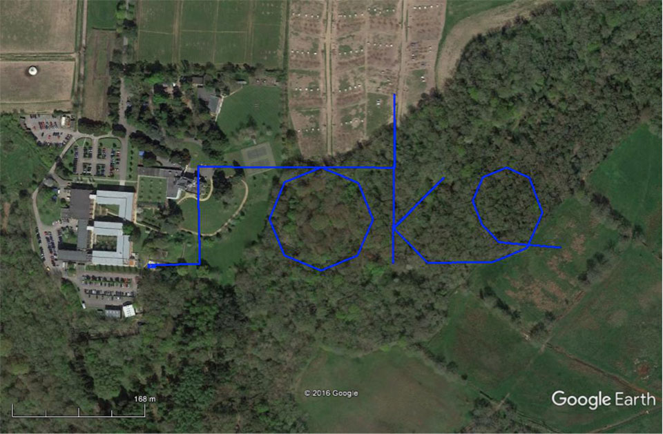
In the first experiment (Figure 2), we spoof a commercially available mass-market receiver. The receiver is outside, reporting its correct location at Roke Manor. When we commence the spoofing attack, we are able to take control of the receiver. Once captured, we can then make the receiver appear to follow an arbitrary course. Here we make it wander off into the forest, spelling the word “roke” as it goes.
Figure 2. Spoofed GPS receiver appears to follow a course, whilst in reality being stationary. (Image: Michael Jones)
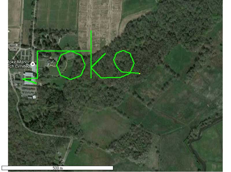
In the next experiment (Figure 3), we place a conventional anti-jam antenna (a CRPA) on the receiver. What we observe, as you might expect, is that the basic CRPA offers no protection against the spoofing attack.
Figure 3. A GPS receiver is still successfully spoofed when protected by a conventional CRPA. (Image: Michael Jones)
Now let’s make the experiment more interesting. We’ll move away from the basic commercial receiver, and replace it with a unit that contains not only a GPS receiver, but also a 3-axis accelerometer, 3-axis gyro, 3-axis magnetometer and a barometric sensor. An Extended Kalman Filter (EKF) performs an optimal fusion of the various sensors to yield the position solution.
The result, when we again try our spoofing attack, is shown in Figure 4. In short, the receiver is still successfully spoofed, despite the additional sensor inputs it offers.
Figure 4. A GPS receiver with integrated inertial sensors is still spoofed. (Image: Michael Jones)
Before everyone gets too depressed by the ease at which GNSS, and even GNSS fused with other sensors, can be spoofed, there are answers to this problem. Some decent, modern GNSS receivers contain a whole host of algorithms for detecting and ignoring spoof signals. The issue is that many legacy receivers are still in the field, and these can be extremely vulnerable indeed.
Another option is to use a more advanced CRPA, which offers anti-spoof capabilities. These adaptive antennas are able to correlate on the spoof signals, and then remove them based on direction of arrival. So, in our final experiment here, we use our commercial mass-market receiver again, and protect it with an anti-spoofing CRPA.
The result is shown in Figure 5. You can see that the receiver is briefly spoofed, and starts to wander off course. When the anti-spoof is enabled and kicks in, the position quickly drifts back to the true location and stays there. Good job.
Figure 5. With an anti-spoof CRPA, the GPS receiver detects the spoofer and quickly returns to its true location. (Image: Michael Jones)
Back to the Black Sea
Let’s finish by returning to the hot topic of the day. Did spoofing occur in the Black Sea back in June? Or was it a different form of interference? Could it have been a low-level jamming incident, causing the GPS receivers to report misleading information?
Without resorting to SIGINT (signals intelligence) data, and basing this discussion solely on public domain information and anecdotal evidence, I would say this was almost certainly a spoofing incident. A number of factors lead to this conclusion, and I’ll share some of them.
Firstly, it didn’t happen to one ship – it happened to over 20 separate vessels. So it wasn’t a malfunctioning GPS unit; it was an external incident of some kind.
Secondly, a large number of ships in the area reported identical or very close locations. This is a symptom of a large-scale spoofing attack. If it was a low-level jamming attack, then any misleading positions reported by vessels would typically have some randomness to them.
Thirdly, ships reported that their positions would periodically “jump” from the true location to the incorrect location. Again, this is very typical behavior in some spoofing experiments: For various reasons, GPS receivers may temporarily lose lock on a spoof set of satellites, and then reacquire the real ones, and vice versa. This causes the characteristic random flipping between two well-defined locations.
If we accept that a GPS spoofing attack did occur, it brings us to the million-dollar question.
Who did the spoofing, and why?
What I’ll do here is a bit of a lightweight analysis exercise using public information and basic physics, and you can formulate your own conclusions.
Let’s start by placing a ship, located in the Black Sea at 44°14.0’N 037°43.1E, which is the actual position of one of the reported spoofed vessels. For this example, I have placed a representative GPS antenna on the ship’s mast, with its antenna pattern shown.
Figure 6. Victim ship in the Black Sea, with GPS antenna pattern shown. (Image: Michael Jones)
To get a rough handle on the scenario, consider the possible propagation of the spoofing signal. As a first-order approximation, let’s assume a standard 4/3 Earth refraction model, with obstruction by terrain. That’s a reasonable assumption at this frequency: Any obscuration by terrain will block the spoof signal. Let’s also initially assume that our GPS antenna on the ship is mounted 38 meters above sea level, and our spoofing equipment is mounted on a mast 20 meters aboveground. From this information, we can plot a map of possible spoofer locations for this particular incident (Figure 7).
Figure 7. Possible spoofing source locations. (Image: Michael Jones)
The first thing we might conclude from this is that the spoofing indeed originates from Russian territory, close to the Black Sea coast. To spoof the ship from further afield would require a much higher antenna, or even an airborne antenna. Which, of course, is possible, but then we would also expect vessels over a much wider area to report interference.
To me, it’s fairly conclusive that spoof GPS signals are being transmitted from this area, to make GPS receivers in the area think they are at an airport. The final question is: “Why would someone do this?” To answer this question, we must resort to educated speculation. Why would you want to spoof GPS receivers into thinking they are at an airport?
There’s one explanation that fits very nicely: drone defense. Many drones, especially those operated by casual users, have geofencing rules that prevent flights over airports and other restricted areas. So, if you were trying to perform aerial surveillance of the Russian border, your drone may suddenly think it was over an airport, and take action accordingly. The action taken depends, of course, on how the drone is programmed, but often includes “land immediately” or “return to launch point.” Certainly some of the drones we operate will immediately attempt to land if they find themselves in restricted airspace.
So if your drones are falling into the sea, you now have one idea why.
Hurricane Harvey is the first major catastrophe in which drones have been used on a large scale by both government and commercial operators, said Ken Long, an analyst at the Freedonia Group.
UAVs are also likely to find widespread use if Hurricane Irma either directly strikes or skirts the east coast of Florida early next week, as current projections show.
In addition to helping keep emergency workers safe by allowing them to look for people trapped by floodwaters and inspect damage in high-risk areas, drone use can speed up the recovery process. Drones can be flown over structures such as fuel tanks, power lines and railroad tracks before they can be reached by land, enabling government agencies and utilities to identify what is in most urgent need of repair.
They also allow insurance adjusters to more quickly process claims, enabling rebuilding efforts to get underway faster. Farmers Insurance reports that an insurance inspector using a drone can complete up to eight times the number of home inspections each day than he or she otherwise would be able to do.
When Hurricane Harvey first made landfall in Texas on Aug. 25, the Federal Aviation Administration (FAA) set up a temporary but extensive no-fly zone over Houston and nearby areas to help protect first responders in helicopters and other manned aircraft. This flight ban included all drone operations except those specifically approved by the FAA.
https://youtu.be/XRdUV4WqnDE
In the 10 days that followed Hurricane Harvey, the FAA issued more than 100 separate authorizations for drone use in the Houston area, according to the Wall Street Journal. Some of the applications for drone use were reviewed and approved by the FAA within hours, an unusually fast turnaround time for an agency that typically takes days or weeks to make decisions.
With the exception of a handful of flights conducted by media firms, all of the approved operations were for drones used in conjunction with, or on behalf of, government agencies. Drones were used to inspect bridges, roadways and power lines; assess the condition of oil refineries and water plants; and survey coastal damage.
As the flood waters continued to recede and flight restrictions were eased or lifted, insurance companies — including Allstate, Farmers Insurance, Travelers and USAA — began to use drones to assess property damage and speed claims processing.
However, drone use by insurance companies and other commercial users is limited by FAA rules that do not allow them to be flown above 400 feet, outside the visual line of sight of the operator, or above people not directly involved in their operation, unless a waiver is granted.
These regulations could change with a 2018 FAA reauthorization bill being considered by Congress.
“The demonstrated usefulness of drones in Hurricane Harvey response and recovery efforts could well influence the content of that legislation,” Long said.
Even if the current FAA regulations remain in place, U.S. commercial drone demand will expand rapidly from what is currently an extremely small market base, according to the Freedonia Group’s Drones (UAVs) study. “Non-military government use of drones will also climb at a robust rate through 2020,” Long said.
Both commercial and non-military government market gains will be fueled by further improvements in drone designs, making them more capable and easier to operate, customized for use in specific applications and cost-saving.
GeoCue Group has released a GNSS positioning system that will allow users of DJI Phantom 4 Pros and Inspire 2 drones, as well as most drones using higher end cameras, to achieve survey-level accuracy with minimum ground control.
Loki, GeoCue’s new direct geopositioning system for small unmanned aerial systems, solves the two fundamental problems associated with this technology:
Positioning Accuracy. Loki uses the new AsteRx-m2 multi-frequency, multi-constellation GNSS engine from Septentrio, which has 448 hardware channels.
Camera Events. GeoCue has invented a patent-pending method of detecting camera events from Phantoms/Inspires and synchronizing those events to GNSS positioning. No modifications to the drone are necessary; the adapter cable is “plug and play.”
GeoCue’s Loki positioning kit uses the Septentrio AsteRx-m2 GNSS engine.
Loki is a self-contained kit that provides all of the hardware and software needed to equip a drone with a post-processed kinematic (PPK) multifrequency, multi-constellation, differential, carrier-phase GNSS.
Using a local base station (not included), Loki provides centimeter-level positioning with minimal, and in some cases, no ground-control points (though GCPs are always recommended for quality assurance).
“GeoCue has been a long-time Septentrio OEM development partner,” said Neil Vancans, vice president of Septentrio Americas. “They have offered our previous generation sUAS board on their high-end AV-900, achieving remarkable results in both accuracy and reliability. By solving the problem of connecting the virtual camera trigger on DJI drones to our AsteRx-m2 GNSS engine, they can achieve professional mapping accuracies with consumer-grade UAVs.”
DroneDeploy of San Francisco has become a leader in cloud-based processing for DJI, as well as other drones. DroneDeploy has enabled users of Phantom and Inspire drones to easily upload drone images, work online with analytics, and download point clouds and orthophotos to desktops for advanced processing.
Without Loki, achieving acceptable network accuracy requires the time-consuming placement of ground-control targets throughout the mapping site.
GeoCue and DroneDeploy have been working together to ensure a smooth Loki-DroneDeploy workflow from field to finish.
“The GeoCue Loki system is an exciting product for anyone using drones to make maps with high accuracy,” said Mike Winn, CEO and co-founder of DroneDeploy. “The Loki’s combination of high-end GNSS positioning and DJI camera synchronization enables survey-grade accuracy with the simplest workflow that we’ve seen — making the Loki a great fit for the DroneDeploy platform.”
“I am very excited to be working with industry leaders such as DroneDeploy on our Loki project,” said Lewis Graham, president and CTO of GeoCue Group. “Loki provides high accuracy positional data to downstream processing solutions. More significantly, it does this for DJI Phantom 4 Pro and Inspire 2 drones. Combining DJI, Loki and cloud processing solutions such as DroneDeploy provides a very streamlined and cost effective solution for high accuracy site surveys.”
The Loki kit includes:
Loki PPK Controller using the Septentrio AsteRx-m2 GNSS engine (GPS L1, L2, L5 and GLONASS L1, L2, L3, 448 hardware channels).
Maxtena M1227HCT-A2-SMA high performance, active, multiband GNSS antenna
Antenna ground plane with mounting kit
Antenna to controller cable
USB cable for data transfer and Loki controller charging
Personality cable (user selects either DJI or DSLR)
AirGon ASP software suite
Mounting kits for DJI Inspire 2 and Phantom 4 Pro
1 year of maintenance and technical support
Loki requires a local multifrequency base station (not included but available from GeoCue). Loki is shipping to early adopter customers in August 2017. It will be available for the general market in September 2017.
It will release with direct support for DroneDeploy and AirGon’s Bring Your Own Drone (BYOD) Mapping Kit. Loki’s introductory price will be USD $4,995. GeoCue is currently accepting preorders.
Loki will be on display September 6-8 at the InterDrone 2017 conference in Las Vegas and at Commercial UAV Expo, also in Las Vegas, October 24-26. A workshop dedicated to high accuracy mapping with DJI drones using Loki is being held in conjunction with the Commercial UAV Expo. Register at www.expouav.com.
Drones have become a serious threat, able to penetrate airspace for surveillance or with an explosive payload.
The Islamic State has used weaponized drones against both Syrian and Iraqi forces; groups like Hezbollah and Hamas have sent drones into Israel and are said to be working on upgrading their UAVs for use in both intelligence gathering and offensive operations.
On April 27, Israel used a Patriot missile to take down a drone entering Israeli Airspace from Syria. At $3 million per missile, the Patriot system is an expensive way to down a device that may only be worth $200. Israel has also intercepted drones with fighter jets.
Systems developed by two Israeli companies provide less expensive — and quickly reactive — solutions.
The Drone Dome system uses Laser, RF and Radar. (Photo: Rafael)
Drone Dome.Rafael Advanced Defense Systems Ltd. has developed a radar and laser-beam system for detecting and destroying drones, with the company adapting its existing laser systems to handle the threat.
Once the system’s radar identifies targets, its laser system destroys them.
Drone Dome also features a jamming system for disrupting communications between the drone and its operator. Drone Dome’s range reaches several miles, but causes minimal interruptions to other systems in nearby urban areas.
The standard Drone Dome system comprises a RADA RPS-42 S-band multi-mission hemispheric radar, a Controp MEOS electro-optical (EO)/infrared surveillance suite, a communications package, and the C-Guard RD jamming and NetSense Wideband detection sensor systems developed by Netline. The UAV threat is neutralized by activation of directional GPS/GNSS and radio-frequency inhibitor/jammer devices.
The RPS-42 is a four-panel tactical air surveillance system delivering 360-degree coverage in azimuth and 90 degrees in elevation, with a detection range of 30 kilometers — including the detection of a minimum target size of 0.002 meters square at a range of 3.2 kilometers — at altitudes from 30 to 30,000 feet. The RPS-42 is designed to detect, track and classify all classes of UAV.
DROM Defense.ORAD’s DROM Drone Defense System can detect an approaching drone at more than 3.5 kilometers away and take command, neutralizing it and landing it far from the operator.
With a weight of 38 kilograms, ORAD’s DROM system comes pre-engineered and pre-assembled. It is mobile and easily deployed on land or at sea in any weather conditions and has an effective coverage range of 3.5 kilometers. It has a 2-kilometer neutralization capability.
Once intercepted, the system can land a hostile a UAV in a pre-defined location, keeping any intelligence it gathered out of enemy hands. It can also identify the location of the operator.
The system’s RF detection unit analyzes signal channels and radio transmissions to spot drones. Once detected, an alarm alerts the system operator.
ORAD has sold the system to clients in several countries including Portugal, Spain and Thailand. The company is in talks with Israeli agencies interested in purchasing the system.
The RFI is an opportunity for industry and governments to submit ideas to define the issues so that global solutions can be proposed, debated and agreed on.
As UAS operations become more complex and are increasingly used for both commercial and recreational purposes, UAS traffic management systems, or UTM, are necessary to seamlessly integrate UAS into the airspace and existing air traffic management systems.
An operational UTM will ensure the safe and efficient use of the airspace as UAS operations become more complex, such as with established navigation routes and point-to-point route segments requiring specific equipage requirements. UTM will integrate UAS into the existing airspace infrastructure to ensure the continued safety of the airspace.
Any framework for a UTM will include many components, three of which are fundamental and will therefore be addressed as a matter of priority:
Registration system from which data is accessible in real time to allow remote identification and tracking of each UA, its operator/owner and location of the remote pilot/control station. To accommodate UA that are increasingly transported from one state to another for either recreational or professional use, this database should allow global access.
Communications systems for control of the UA and for tracking all UA within the UTM area. The communications system used for tracking UA must be able to identify when a manned aircraft is entering UTM airspace and provide an acceptable level of protection between it and UA operating in the airspace. Furthermore, it must facilitate detection of potential collisions with other UA and with obstacles such that appropriate avoidance action can be taken.
Geofencing-like systems that will support automatic updates by national authorities on the 28-day aeronautical information regulation and control (AIRAC) cycle to prevent UA operation in sensitive security areas and restricted or danger areas such as near aerodromes.
ICAO is soliciting proposals for a global framework for UTM ahead of its Drone Enable UAS Industry Symposium, which will take place in Montreal, Canada, in September.
“ICAO is the natural agency to be gathering together the best and brightest from governments and industry to define the problem so that global solutions can be proposed, debated and agreed on,” said Leslie Cary, ICAO remotely piloted aircraft systems program manager.
“Collaboration between stakeholders is key to addressing complex issues such as UTM,” added Brian Wynne, president and CEO of AUVSI. “AUVSI is pleased ICAO is taking steps to explore solutions for UTM that will allow companies to operate globally under the same standards, reducing barriers to innovation and improving safety and security for all aircraft – both manned and unmanned. We look forward to working with ICAO to draw awareness and facilitate industry engagement in the RFI process.”
For more information about the RFI, visit ICAO’s RFI website. Submissions need to be received no later than July 15.
A May 19 meeting convened by the American National Standards Institute (ANSI) confirmed there is broad-based support among key stakeholders from the private and public sectors for ANSI to establish an Unmanned Aircraft Systems (UAS) Standardization Collaborative (UASSC).
The UASSC will work to coordinate and accelerate the development of the standards and conformity assessment programs needed to facilitate the safe, mass integration of UAS (drones) into the national airspace system of the United States.
Initial priority areas of focus are expected to include:
UAS airworthiness
command and control systems
remote identification
flight operations, including operations over people and beyond visual line of sight
licensing, training, qualification and certification
sense and avoid systems
safety and risk management
An initial kick-off meeting is anticipated in the third quarter of 2017. To stay up to date regarding future developments, email Jim McCabe, ANSI senior director, standards facilitation, at [email protected].
The collaborative will also focus on international coordination and adaptability, with the goal of fostering the growth of the UAS market. The work effort will entail the development of a standardization roadmap to identify existing standards and standards in development, define where gaps exist and recommend additional work that is needed, along with a timeline for its completion and organizations that can perform the work.
ANSI Standardization Collaboratives are formed to support emerging technologies and national and global priorities by advancing cross-sector coordination in the development and compatibility of standards and conformance programs.
Ultimately, the purpose of such initiatives is to describe the current standards landscape, articulate standardization needs, inform resource allocation for standards participation, and drive coordinated standards activity while minimizing duplication of effort.
As a neutral facilitator, ANSI has a successful track record of having convened a number of such collaboratives in areas as diverse as homeland security, electric vehicles, energy efficiency in the built environment and, most recently, additive manufacturing.
The May 19 meeting drew close to 70 participants representing more than 40 organizations from industry, trade associations, standards developing organizations (SDOs), federal agencies, academia and others. The public- and private-sector co-chairs for the meeting were Earl Lawrence, director of the UAS Integration Office, Federal Aviation Administration, and Brian Wynne, president and CEO of the Association for Unmanned Vehicle Systems International (AUVSI).
ANSI has been in dialogue with numerous stakeholders over the past year on this topic, including via panel discussions during the 2016 ANSI Joint Member Forum and at the April 2017 ANSI Company Member Forum. A number of SDOs already are involved in UAS standardization, underscoring the need for coordination to achieve a coherent set of standards.
“Given our history of bringing public- and private-sector stakeholders together to identify standardization needs to support new technologies, ANSI is well suited to facilitate the need for standards coordination in this exciting new technology area,” said ANSI president and CEO S. Joe Bhatia.
Inertial Sense will be releasing a high-quality, low-cost navigation system — the μINS — later this summer, the company said. The company made the announcement at AUVSI’s Xponential 2017.
Inertial Sense is a privately owned U.S. company that specializes in designing and manufacturing GPS inertial navigation technology for commercial and consumer products.
Historically, quality GPS inertial navigation has been expensive and was only designed into a small number of systems. As the commercial and consumer drone industries grow, the need for an accurate, low-cost navigation system has become more apparent, Inertial Sense said.
Acccording to Inertial Sense, the company’s engineers have invented a design that enables the technology to be smaller and less expensive.
The μINS is a tiny sensor module that is designed to provide high-quality direction, position and velocity data for drones and robotic applications. It provides this data by fusing sensor data from GPS (GNSS), gyros, accelerometers, magnetometers and a barometric pressure sensor.
IBM’s inventors have been granted a patent for transferring packages between drones during flight.
The invention, described in U.S. Patent No. 9,561,852: In flight transfer of packages between aerial drones, helps to extend the range of drones that are delivering packages from a warehouse to a customer’s home.
IBM inventors developed this patented system using their supply chain expertise to enable precise delivery services to customers using drones.
Drones are starting to be used to transport packages to customer locations, but there are still numerous challenges to this delivery method such as limited flight range, theft of unattended packages once delivered, and a lack of delivery network optimization.
The invention can help to mitigate these challenges by providing in-flight drone-to-drone package transfers to extend package delivery range.
For example, a customer expecting a package could dispatch a personal drone to receive and securely deliver the package to the customer’s home. Drone delivery network optimization could be provided to autonomous drones via the communications link described in the patent.
“Drones have the potential to change the way businesses operate and by leveraging machine learning, drones could change ecommerce,” said Sarbajit Rakshit, IBM master inventor and co-inventor on the patent. “Our inventor team is focused on improving how the most valuable cargo is delivered globally. This could create opportunities such as managing drones to deliver postal packages and medicine in developing countries via the most direct route.”
IBM inventors have patented other inventions related to drones and drone-enabling technologies. However, this is just one aspect of IBM’s Supply Chain and Logistics expertise. IBM manages supply chains for clients on a worldwide basis using IBM Watson Supply Chain. Learn more about IBM patents here.
China Eagle’s Sharp Sword is in prototype testing.
China Eagle is building the country’s largest production base for industrial drones.
A Beijing-based UAV developer, China Eagle is maker of the Divine Eagle and the Sharp Sword stealth drones. The firm also works with the state oceanic administration to produce drones for shore patrols.
The production base in Jingjiang’s economic and technological development zone in east China’s Jiangsu province is expected to produce its first industrial UAV this month. The drones will be designed for mapping, aerial inspection and unmanned cargo transport.
With an investment of 510 million yuan ($74 million), China Eagle’s new production base is designed with an annual production capacity of 5,000 units. Its total output value is estimated at 3 billion yuan a year. Analysts say the general aviation sector is unable to meet the needs of industrial customers in China, where demand is high.
A fourth speaker has joined the panel of the free April 20 webinar, “From Flying Drones to Doing Business,” addressing UAVs in business applications. Francois Gervaix, product manager of surveying for senseFly, will address the business benefits of high precision GNSS, covering: high precision in photogrammetry drones, survey-grade accuracy, workflow flexibility and time/cost savings.
Webinar attendees will have the opportunity to ask direct questions of the speakers, both upon registration and during the live event. Register for free at env-gpsworld-integration.kinsta.cloud/webinar.
Gervaix joins a panel consisting of Gustavo Lopez, product manager GNSS solutions for UAV applications for Septentrio; Jan Leyssens, managing director of sales and business development for Airobot; and Zak Kassas, assistant professor in the Department of Electrical and Computer Engineering at the University of California, Riverside.
Other subtopics to be covered include the integration of various surveying and mapping sensors aboard a UAV platform; meeting safety demands for UAVs by providing intelligent safety components, specifically designed for drones, and in facilitating end-users’ success in completing their missions; and exploiting long-term evolution cellular signals for accurate and resilient autonomous vehicle navigation in the absence of clear GNSS signals.
Gervaix is a qualified geomatics engineer who has worked for Leica Geosystems and as a professor at the Technical University for Applied Sciences Western Switzerland. In 2010, he launched project R-Pod, Photogrammetry on Demand, before founding Easy2map, a drone-based photogrammetry service provider. He joined senseFly in February 2016. He is also president of the Swiss Society of Photogrammetry and Remote Sensing.
Assessing the health of an entire industry is not an easy task, but talking with industry leaders and looking for examples of growth and investment can help. My inquiries have led to discussions with General Atomics, Association for Unmanned Vehicle Systems International (AUVSI), Aeryon Labs and SensoFusion. Further viewpoints welcome; see the conclusion of this article.
Discussions included questions around these issues:
The level of maturity of common technologies in use on UAV platforms and systems
The level of maturity of integration of those technologies
A sketch portrait of the industry
Rough numbers or percentage of small players versus large ones
The rate of consolidation of companies: Has it happened, or has it yet to happen?
The financial underpinnings of the market: Does it have legs to go the distance?
If we start with a top-level overview of the industry, we find on the commercial side an industry trying to figure out what it is and who its customers might be. But a well-established military segment is quite mature. A large number of multi-rotor UAV suppliers use simple handheld controllers, all aimed at different applications where they are seeking a niche. The FAA’s release of regulations last year for use of small unmanned vehicle systems (sUAS) has provided a real boost to many more commercial pay-for-service ways these vehicles are now being used.
Multi-rotor UAVs are being put to use in surveying, filmmaking, newsgathering, real estate, crop and pipeline inspection, firefighting, law enforcement, security, search and rescue, and disaster monitoring and relief, just to mention a few applications. Of course, home and hobby flying your own drone in your backyard or open areas has fueled the Chinese DJI drone manufacturers’ growth significantly. While the FAA requires registration of private drones, this has not prevented an increase in commercial pilot reports of UAV incursions into controlled airspace, which appear to be on the increase.
Military Use. Then there are small, medium and large fixed-wing UAVs that appear to have been mostly developed for and used by the military. These include hand-launched surveillance drones for small groups of ground troops; mid-sized, longer range surveillance drones finding applications in commercial inspection; and the bigger GA Predator type aircraft that have become the U.S. military’s search and destroy long-range vehicle, which can carry significant ordinance.
At the top end, UAVs like Global Hawk are used for very high altitude, long-endurance surveillance. Finally, we have target drones like the Northrup Grumman BQM-74E, which earns its living pretending to be an enemy anti-ship cruise missile for the U.S. Navy.
Northrop Grumman’s BQM-74E Target Drone works for the U.S. Navy. (Photo: U.S. Navy)
Commercial Growth. Brian Wynne, president and CEO of the Association for Unmanned Vehicle Systems International (AUVSI), believes for the commercial segment that, “The UAS industry is primed for incredible growth. UAS are being used in all 50 states by industries like real estate, agriculture and the oil and gas industry for more than 40 different types of business applications, including aerial photography, emergency management and utility inspection.”
More than 500,000 people have registered their UAVs with the FAA in the U.S., and around 20,000 of those are looking to start commercial operations. AUVSI expects more than 100,000 jobs will be created when UAS are integrated into and allowed to operate in the U.S. National Airspace System (NAS).
AUVSI analysis of initial UAS applications. (Source: AUVSI)
However, Wynne went on to comment, “This this can only happen if the government puts in place a true, holistic plan for full UAS integration that includes flights over people, as well as beyond line-of-sight operations, access to higher altitudes and platforms above 55 pounds.” AUVSI estimates that in the first decade after full UAS integration into the NAS, these commercial operations could generate more than $82 billion is economic impact.
Even before the FAA’s release of formal regulations (known as Part 107) for use of sUAS in June 2016, more than 5,500 businesses received approval to fly for commercial purposes. AUVSI published a report analyzing these applications: “Commercial UAS Exceptions By the Numbers” provides an overview of the developing commercial UAS industry in the U.S. (See auvsi.org/advocacy/exemptions70)
More than 90 percent of these businesses make less than $1 million in annual revenue and have fewer than 10 employees. This indicates that the engine behind this growth comes from small, independent business.
Nevertheless, big organizations such as CNN are also exploring visual line-of-sight operations over people and safely using UAS for newsgathering in populated areas, as part of the FAA’s Pathfinder Program. PrecisionHawk is testing extended visual line-of-sight operations in rural areas, aimed at precision agriculture, and BNSF Railway is testing beyond visual line-of-sight (BVLOS) operations in rural and isolated areas for the inspection of rail system infrastructure.
Anti-Drone Systems. More recently, anti-drone systems have joined the party to help defend against unwanted UAV incursions into secure areas already protected by conventional systems like radar, acoustic and optical detection systems. Secure areas include prisons, government buildings/facilities, utility companies (including nuclear power stations) and airports. Sensofusion in Finland is one such company with its Airfence, one of three anti-drone systems tested last November by the FAA at Denver airport. The other systems were supplied by CACI International and Liteye Systems.
The Airfence drone countermeasure platform can automatically detect, locate, track and take over UAV controls as well as locate the operator.
Kaveh Mahdavi, VP of Operations for Sensofusion, thinks that, relatively speaking, the UAV industry is quite mature — what’s still being developed are systems to enable autonomous drone flight. The regulations published so far only address ground-pilot-controlled operations, even though BVLOS testing is progressing well.
On the other hand, the maturity level of anti-drone systems range from proven to embryonic. As many as 50 companies with different technical solutions are vying to succeed in this new segment.
As the UAV segment continues to grow, so does the need for detection and prevention of drone incursions.
These systems employ three basic technologies: radar, optical and RF. Radar and optical need direct line of sight and cannot see over the horizon. That makes them quite short-range, and detection and defense has to be exceptionally quick to prevent unwanted UAV visits. The Airfence RF system is omnidirectional and can even detect UAS preparing for take-off up to six miles away, as demonstrated at the Denver airport.
Thus, intrusion warnings at a geofence distance of 3–4 miles can be generated, and automatic defense/prevention is readily achieved. Some utility companies want to have detection, warnings and control of intruder drones within a mile of their facilities.
Mahdavi described how Airfence uses a library of drone control RF signatures for all known UAS, with new signatures added regularly. The system can detect, intercept and directly take control of the offending vehicle.
During the Denver tests, Airfence initially only detected one third of the target UAVs, but the RF signatures of all targets were acquired.
Using remote engineering updates to the library, by Day Three all were detected. With lower prices, consumer drones are becoming a real threat for these sensitive areas.
The anti-drone industry will no doubt face considerable consolidation over the next couple of years, but Mahdavi feels that Sensofusion is well placed, with significant military and government business funding its growth — “securing the right contracts with the right customers,” as he says — without external investment.
Mature Company. General Atomics Aeronautical Systems Inc. (GA-ASI), makers of the well-known Predator, Reaper and other Medium-Altitude Long-Endurance (MALE) drone systems, has been in this business for almost 25 years. GA-ASI considers its products to be proven, mature and resilient for the military and government markets that demand them to be so. The company uses in-house products and technology across its range of air and ground systems.
SeaGuardian and SkyGuardian will be commercially certifiable versions of the Predator.
In an effort to align with European customer interest, GA-ASI has been investing in a certifiable version of the Predator-B, recently named SkyGuardian. A derivative for marine applications will be known as the SeaGuardian.
Just as military transport aircraft want to transit through civilian airspace and, in order to do so, have been equipping with certified navigation systems for a number of years, military drone operators want to be compatible with Europe’s high-density commercial flight regulations and to operate within existing air-traffic control corridors.
To arrive in time for these European programs, GA-ASI has invested to get ahead of the market. This has entailed assessment of all on-board and ground components, and has led to upgrades and redesigns where necessary.
“Nevertheless, on existing product lines, there is a large degree of commonality across common systems on multiple platforms,” said Mike Cannon, VP of international programs. Common systems include datalinks, avionics, de-icing systems, and some airframe components.
GA-ASI has developed and integrated its own flight control system in its aircraft for more than 20 years. This has proven to be a key element of the success for the Predator family of products. Because all these systems have been flying for so long, they have become proven elements of their unmanned systems.
Hughes Network Systems Defense and Intelligence and Systems Division (DISD) has been selected by GA-ASI to provide satellite communications on the type-certifiable Predator B remotely piloted aircraft (RPA) system. Working with GA-ASI, Hughes will customize the aircraft’s satellite communications system with modified Hughes HM series modems. The advanced modems will enable a significant increase in data transfer rates, using an enhanced waveform that ensures resilient and secure communications when operating in challenging environments.
Big Players. It is very difficult for new start-up companies to enter this top-level segment of the UAV market. It’s very expensive to develop, demonstrate and prove large airframes, control systems and avionics that customers can rely on. GA-ASI has a unique position alongside major suppliers such as Boeing, Northrup Grumman, Israel Aerospace Industries, and Lockheed Martin. However, viable Chinese UAS are beginning to show up in the marketplace, apparently as a result of significant, focused investment.
Nevertheless, with an enviable position as a major supplier of platforms used in multiple applications, with sufficient internal resources to fund initial vehicle developments, GA-ASI has secured a large number of programs with multiple follow-on orders and funding for increasingly more capable derivative UAS. As the company now looks toward the certifiable segment using another internally funded product launch, it is again reinforcing its leadership position in its chosen unmanned market segment.
Small Vehicles. Meanwhile, the world of small unmanned air vehicles (sUAS) continues to thrive, given the release of FAA regulations last year, and the blossoming of many commercial applications using increasingly capable small multi-rotor drones. David Koetsch, CEO and co-founder of Aeryon Labs in Ontario, Canada, thinks the sUAS segment is also quite mature.
Aeryon has been around for more than 10 years, so it has also had time to prove its platforms and internal systems. It also builds its own flight-control hardware and software, affording substantial power savings and longer endurance from automatically managing rotor speeds.
Aeryon Labs provides complete solutions, such as its SkyRanger sUAV partnered with AeryonLive Tools software.AeryonLive Tools software. by Aeryon Labs.
“The quad platform has been around since 1938, so the concept is hardly new; however, over the last decade, Aeryon Labs has substantially matured and ruggedized our platform, the Aeryon SkyRanger sUAS,” Kroetsch said.
The company’s focus is on not only on the UAV platform, but also in supplying complete systems meeting different customer needs. With electro-optical and thermal imaging camera payloads and an onboard georeferencing data collection/processing system, it provides integrated solutions such as AeryonLive Video and Telemetry and AeryonLive Fleet Management using real-time software tools.
For the oil and gas industry, providing compatibility for off-line flight planning software inputs and importing compatible aerial imagery into existing GIS systems is a significant feature. The SkyRanger UAS has benefited from many years of use in the field, and has been designed with modularity and ease of use with snap-on/off parts that make set-up and operating in bad weather a lot easier.
Aeryon’s business is currently 50% military, 25% oil and gas and 25% public safety (such as rapid traffic accident data gathering). Other entrants to these segments might find it easy to put together an unmanned system from parts bought on the internet; what comes considerably harder is proving reliability and interoperability with existing customer systems.
Actually, to develop an industrial-grade UAV takes lots of investment and requires experience gathered over many years. Customers have learned how to differentiate between those dabbling in the market and those with serious capabilities.
Consolidation. Consolidation is inevitable in this market segment — perhaps within the next six months, certainly over the next two years — because there are so many companies trying. Investment for these start-ups is getting harder to find, and it may be too late for most, as the leaders are already well established.
“It’s essential to pick a niche within the increasingly competitive UAV industry,” Kroetsch said. “This is why Aeryon chose early on to focus on enterprise-level offerings in commercial, public safety and military.”
Recall what happened to 3D Robotics. Even though 3D Robotics raised many millions in funding, its Solo quadrotor fell from grace, perhaps due to continuing design issues and being higher priced compared to rapidly declining DJI Phantom 3 prices. “Competition and consolidation look to be very similar to that which happened with digital cameras,” Kroetsch said.
For Aeryon, being Canadian appears to be an advantage, as U.S. export regulations seem to be handicapping U.S. drone manufacturers. Aeryon sells in 35–40 countries because its product does not contain military-restricted components and only uses commercial parts. Canadian regulations for drone system exports do not prohibit worldwide sales for such products, while U.S. regulations can be difficult for U.S. suppliers to negotiate.
Nevertheless, unexpected hurdles to adoption still exist, such as company policies related to health and safety, union restrictions, and potential internal clashes on responsibility for implementation. But with 100% test, and a hardened design for tough environments, Aeryon sees itself well positioned to grow in its chosen industrial sector.
Conclusion
This has been a brief overview of the UAV/UAS industry — a first try, if you will. Nevertheless, it’s a summary that we can use as a benchmark for where we are right now, and a departure point for future growth.
We have quite mature capability in both large and small UAS, with integration focused on flight-control and navigation systems. The larger UAS enjoy a relatively mature market with established suppliers of lower numbers of expensive systems, while the sUAS segment is larger, younger and less expensive, with fewer barriers to entry.
Nevertheless, the mature industrial segments with harder, more integrated requirements make it difficult for new entrants to climb the steps into more complex commercial operations. The recreational segment is dominated by DJI, and it remains strong with well-performing, easy-to-operate drones.
Because of the ease of access to smaller drones, despite FAA and other countries’ regulations, people seem to want to penetrate secure facilities like utilities, airports, military bases, prisons and other government locations. Therefore, anti-drone systems using optical, radar and RF are becoming available, and facilities are being equipped to prevent unwanted drone incursions.
AUVSI XPONENTIAL. In May, I’ll be roving the show floor at the XPONENTIAL show in Dallas, and I welcome your added insight, from all corners of the UAV industry. We will continue this assessment in an upcoming
Professional OEM + UAV newsletter column (subscribe free at gpsworld.com/subscribe).