Tag: drones

  • Quanergy announces new lidar sensor at Xponential

    Quanergy Systems, a provider of lidar sensors and smart sensing solutions, is offering a new sensor.

    Quanergy's S3 lidar sensor
    Quanergy’s S3 lidar sensor

    The S3-Qi is a miniature solid-state lidar sensor that is 15 percent the size of the previous solid-state model, the S3. Quanergy is displaying the new sensor along with its other products in Booth 767 at AUVSI’s Xponential May 3-5 in New Orleans.

    The S3-Qi, offered four months after the original S3, has a smaller 1 inch by 1.5-inch footprint, weighs about 100 grams and has low power consumption. The small form factor, combined with a cost-effective design, makes the S3-Qi well suited for applications such as drones, intelligent robotics, security, smart homes and industrial automation.

    Mass production of the S3-Qi is targeted for the first quarter of 2017.

    “We are excited to raise the bar, once again, with the expansion of our product portfolio,” said Louay Eldada, Quanergy CEO. “We continue to push the boundaries on behalf of our customers. The S3-Qi is a testament to our focus on the user and our investment in innovation for game-changing smart sensing solutions offered at price points that make their use ubiquitous. In drones, payload and battery runtime benefit greatly from our compact sensors.”

    Quanergy’s lidar sensors have applications in more than 30 market verticals including security, transportation, terrestrial and aerial mapping, and industrial automation.

  • Live from AUVSI’s Xponential 2016

    UnmannedSystemsLogoThe GPS World and Geospatial Solutions staff is reporting live from the Association for Unmanned Vehicle Systems International‘s (AUVSI’s) Xponential 2016 May 2-5 in New Orleans. The event convenes the global community of commercial and defense leaders in intelligent robotics, drones and unmanned systems.

    More than 8,000 industry leaders and professionals from more than 55 countries are discussing the latest innovations in the unmanned systems market this week. Hundreds of educational sessions are providing information about the future of unmanned systems policy, regulations and technology. Also, the show’s Startup Showdown has $15,000 in cash prizes and mentorship opportunities for start-up companies.

    Award-winning journalist Miles O’Brien, the science correspondent for PBS NewsHour, is hosting the event. Keynote speakers include Michael P. Huerta, administrator of the Federal Aviation Administration (FAA); Gen. David G. Perkins, commander of the U.S. Army Training and Doctrine Command; Gur Kimchi, co-founder and vice president of Amazon Prime Air; and John Chambers, executive chairman of the board of Cisco Systems.

    A panel of industry thought leaders, moderated by AUVSI’s president and CEO Brian Wynne, are discussing the future of unmanned systems: U.S. Rep. Frank LoBiondo, chairman of the House aviation subcommittee; Frank Kelley, deputy assistant secretary of the U.S. Navy for Unmanned Systems; Marke Gibson, senior advisor for UAS integration at the FAA; and John Cavolowsky, Ph.D., director of NASA’s Airspace Systems Program.

    Check back throughout the week for event updates, including news, photos, videos, tweets and more.

    NEWS

    Trimble offers GNSS module for system integrators (5/5)

    FAA establishing advisory committee on UAV integration (5/4)

    DJI, PrecisionHawk partner on UAV remote sensing for agriculture (5/3)

    SOAR Oregon backs UAS FutureFarm for digital agriculture (5/3)

    IMSAR sells UAV detect-and-avoid radar tech to Fortem (5/3)

    FLIR launches radiometric thermal camera for commercial drones (5/3)

    VectorNav launches tactical series of IMUs at AUVSI show (5/3)

    Commercial drone services could reach $8.7 billion annually by 2025 (5/2)

    Quanergy announces new lidar sensor at Xponential (5/2)

    Echodyne offers detect and avoid radar for small UAS (5/2)

    Arcturus VTOL UAS deployed with the Mexican Navy (5/2)

    uAvionix debuts pingRX receiver for small drone collision avoidance (5/2)

    Insitu to focus on new commercial division at Xponential 2016 (5/2)

    VIDEO PLAYLIST

  • AUVSI releases interactive analysis of FAA UAS exemptions

    The Association for Unmanned Aerial Vehicles (AUVSI) unveiled an interactive analysis of U.S. Federal Aviation Administration (FAA) Section 333 unmanned aircraft system (UAS) exemptions.

    The FAA has awarded more than 3,000 Section 333 Exemption Grants since September 2014 to allow individuals, businesses, non-profits and governmental agencies to fly drones.

    AUVSI’s Unmanned Systems and Robotics Database provided the data for the analyses, which shows UAS exemptions by state and month, a business analysis revealing revenue and employees, UAV applications, top manufacturers, top drones, airframe and industry.

    The report finds that finds 38 types of business operations have been approved by the FAA to fly UAS commercially in the National Airspace System (NAS). Aerial photography received the most, followed by real estate and aerial inspection.

    The report also finds that exemptions have been approved in all 50 states, as well as Puerto Rico.

    “The UAS industry is poised to be one of the fastest growing sectors in the U.S., and these numbers demonstrate that a wide variety of industries are eager to take advantage of this technology,” said Brian Wynne, president and CEO of AUVSI. “From inspecting our nation’s infrastructure to providing farmers with aerial views of their crops, the applications of UAS are virtually limitless. It’s no wonder businesses – small and large – are clamoring to use this technology.”

    Congress also mandated that the FAA develop rules for integration of UAS into the national airspace, however these rules, which would provide anyone who follows the rules access to the airspace, are not expected until at least June 2016.

  • US airports take part in pilot program to enable safer UAS flights

    AirMap-2
    The AirMap Digital Notice and Awareness Dashboard(TM) airport manager view.

    AirMap and the American Association of Airport Executives (AAAE) have released the Digital Notice and Awareness System (D-NAS), created to allow UAS operators to provide airports with real-time digital information about the location of their flights.

    AirMap is a provider of airspace information and services for unmanned aircraft. On April 7, the company announced that it raised a $15 million Series A financing led by General Catalyst Partners to accelerate its global development airspace management tools for drones.

    D-NAS works by allowing a UAS operator to send an encrypted digital flight notice to a secure dashboard at an airport’s operations center. Flight information can be submitted through various UAS interfaces, including the flying apps provided by drone manufacturers DJI, Yuneec and 3DRobotics.

    These connections facilitate the transmission of important safety-critical information to airports, including the GPS location of the UAS flight. Participating airports will access this information through the AirMap D-NAS dashboard, which provides a map view of flights in proximity to the airport and the option to contact the UAS operator directly.

    “Safety has always been a priority for DJI,” said Brendan Schulman, DJI’s vice president of Policy and Legal Affairs. “Providing our customers the capability to easily notify nearby airports of their flights is a huge step forward in convenience and functionality.  A high-tech notification system complements the safety features DJI builds into every drone, as well as DJI’s close work with policymakers on practical approaches for drone technology.”

    More than 50 airports across America have already joined the D-NAS pilot program, including Houston’s George Bush Intercontinental and William P. Hobby airports, Denver International Airport, Columbus Air Force Base in Mississippi, Charlotte-Douglas Airport in North Carolina, Reno-Tahoe Airport in Nevada, New Castle Airport in Delaware, Cape May Airport in New Jersey, Fairbanks International Airport in Alaska, and the Oxnard and Camarillo Airports in Ventura County, California.

    AirMap-1
    The AirMap Digital Notice and Awareness Dashboard map view.

    “Participation in the D-NAS pilot was a no-brainer for us. In the face of growing concerns over UAS operations near airports, AirMap has developed an effective and unique solution,” said Steve Runge, Division Manager for the Houston Airport System. “D-NAS is a game changer for how we will manage low altitude air safety.”

    D-NAS not only provides heightened awareness to airports; it also makes it easier for UAS operators to comply with Section 336 of the FAA Modernization and Reform Act of 2012, which requires notice to be given to airports within five miles of a drone’s flight location.

    Ben Marcus, CEO of AirMap and an airline transport rated pilot and flight instructor, said, “Everyone involved in aviation sees the promise and potential of unmanned aircraft. However, we can’t reach the potential of this amazing technology unless we ensure that safety critical information keeps pace with innovation. We are focused on building the tools for unmanned aircraft to safely integrate into the national airspace system.”

    “We are excited to work with AirMap to improve the safety features of our products,” said Yuneec CEO Tian Yu. “As an airplane and helicopter pilot myself, I know first-hand how important it is to keep the national airspace system safe.” Yuneec is the manufacturer of the Typhoon and Tornado series of multirotor drones and recently announced a $60M investment from Intel.


  • Expert Opinions: Apps for drones, UAV market sector and new regulations

    Q: What is the “killer app” for professional use of drones? What UAV market sector will most powerfully drive adoption and influence new regulations?


    Jan Leyssens Product Manager, Septentrio
    Jan Leyssens
    Product Manager, Septentrio
    A: The mapping market is opening up. On construction and mining sites, surveyors walk between dozers and dump trucks to create digital terrain models, a time-consuming and dangerous job, which drones can do more efficiently and safely. These jobs are performed in non-public areas, without significant risks or privacy concerns, facilitating public acceptance. Subsequently the potentially larger inspection market will open up. Drones provide an easy, safe way to inspect wind turbines or other installations that are difficult or dangerous to reach.


    Tony Murfin Contributing Editor, Professional OEM & UAV, GPS World
    Tony Murfin
    Contributing Editor, Professional OEM & UAV, GPS World
    A: The agriculture industry seeks even greater Improvements in crop yields. GNSS systems in the cabs of combines/harvesters have already helped significantly, but drone use for crop-growth monitoring, data collection and pesticide-prescription application is the big breakthrough — once rules for large-scale low-level drone flight over farmland are approved. Ag will push for published rules just as hard as the movies, real-estate and all types of aerial survey for construction and utilities.


    Eric Gakstatter Contributing Editor, GIS & UAV, Geospatial Solutions
    Eric Gakstatter
    Contributing Editor, GIS & UAV, Geospatial Solutions
    A: Amateur photographers and hobbyists are where the volume is. The world’s largest UAV manufacturer now exceeds $1B annual revenue. Its growth is being driven by the hobby market. Commercial use of UAVs is a very small piece of the worldwide UAV market. The UAV market will be very similar to the GPS receiver market, just not at the same scale. The volume in the UAV consumer market will drive the technology (sensors, motors, software) that will benefit commercial UAV manufacturers.

  • DataCapable’s Paul Beckwith on commercial drone regulations

    Paul Beckwith of DataCapable describes the company’s open data products for emergency response, using nontraditional data sources such as social media and weather. He was interviewed by GeoIntelligence Insider columnist Art Kalinski for Geospatial Solutions at the Esri Federal GIS Conference, held Feb. 24-25 in Washington, D.C.

  • The year of UAVs for Europe

    The unmanned aerial vehicle (UAVs) sector is a dynamic GNSS-enabled sector globally and Europe is no exception. In January I attended a UAV event at the Royal Military Academy in Brussels. The focus of the two-day meeting was on small commercial and recreational remotely piloted aircraft systems (RPAS) that are rapidly populating Europe’s airspace.

    Currently, there is no European legislation that governs their use in conjunction with general aviation and, typically, national legislation varies across the member states. Regulators are trying to play catch-up.

    One interesting EU project trying to tackle this situation is DroneRules.EU. Philippe Carous of SpaceTec Partners said the project’s main objective was to raise general awareness of the rules governing RPAS across the commercial sector and the general public. Speaking as an occasional drone operator – I own a Parrot 2.0 – I must admit I was oblivious of the legal minefield I am potentially entering every time I fly my ‘Boy’s Toy’ around the garden!

    The project covers three main areas: privacy and data protection; safety and operation; and insurance and liability. The plan is to establish a set of useful tools on a web portal including awareness, training tools and online resource covering rules at national level plus regulatory developments. The website should be available mid-2016 at www.drone-rules.eu.

    Rachel Finn of Trilateral Research, a partner in the DroneRules.eu project, talked about privacy and data protection issues which bring some complex rules and liabilities into play as drones are increasingly becoming data collection devices. The company undertook a survey of users for the European Commission and identified private users as the least regulated and most at risk of breaching the rules. Commercial users were seen as medium risk. “Using the same drone with the same payload in different contexts can raise different or new privacy and data protection issues,” said Rachel. Each mission may need to be individually risk assessed.

    Listening to the discussion here, it seemed to me that privacy issues could effectively turn any urban area into a ‘no-go’ zone for civil drones let alone other considerations on safety and so on.

    The Brussels conference was organised by UVS International, whose president Peter van Blyenburgh is a blunt-speaking and passionate advocate for the civil RPAS operating community in Europe.

    On 4 March a further workshop took place at EUROCONTROL headquarters in Brussels with the purpose of discussing the future working arrangements and work programme for the development of RPAS standards. Peter van Blyenburgh tells me that not a single RPAS operator had been invited to air their views at this forum.

    From the discussions at the workshop it was clear, according to van Blyenburgh, that international, European and national standards organisations are not coordinating their work and consequently there is significant duplication and wasted effort. However it was decided that a single working group will be established to tackle standards work for all sizes of RPAS and terms of reference for this group should be finalised by the middle of June 2016.

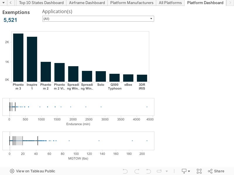
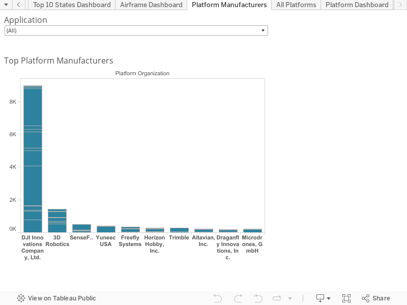
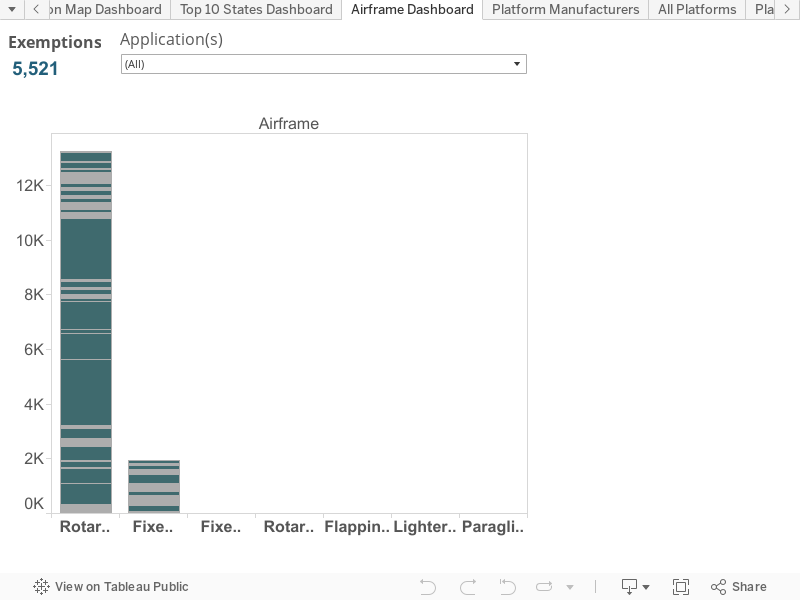
    During the workshop  van Blyenburgh expressed his views on the absolute necessity that RPAS operators and new disruptive technology companies must participate in the work on standards and as there was a large number of light RPAS (<25 kilograms) already flying, it was also imperative to tackle the standards applicable to them as a priority.

    Van Blyenburgh takes the view that if the RPAS community is not careful and proactive, their commercial future may be set by standards produced by the traditional airspace players that are not directly involved with their specific community, nor really understand it. It is hard to disagree with his views here.

    “Of course, at the same time, the RPAS communities should both remember that airspace safety is a common responsibility that should be proportionately shared by all RPAS community members,” he adds. “Defining this proportionality will be one of the keys to success.”

    Polish solution?

    If  regulations are lacking, technical solutions are ready to roll. One European initiative based in Poland seems to have a viable monitoring and control system developed for drones/ RPAS: The Drone Monitoring System (PSMD) was presented by Justyna Zdanowska of the Grupa Dron House S.A.

    The Polish solution can monitor drones in near real-time (the company claims a maximum delay of one second) using GSM and/ or GPS technologies and has the ability to manage the drone online through an application. They say this is the first successful development of such technology that is operational and ready for implementation. It has already attracted the interest of some major aerospace players, drone users and the authorities as the system could solve the issue of uncontrolled flights and other problems.

    “We offer a complete, ready-to-use system that will radically improve the safety of air traffic, because the drone market is developing at a dynamic rate in an uncontrolled manner,” says Justyna Zdanowska.

    The technology also has a huge capacity with up to 18 000 devices controlled and/ or monitored by a single base station at a given location. This should allow full monitoring and identification of unmanned devices.

  • Commercial drone sales to rise by 84 percent in 2016

    A new study from U.K.-based Juniper Research has found that annual revenues from commercial drones sales are expected to reach $481 million this year, up 84 percent from last year’s figure of $261 million.

    The new research — “Drones: Consumer & Commercial Applications, Regulations & Opportunities 2015-2020” — found that a low price point had significantly reduced the barrier to entry in many sectors, with high-performance models now available for less than $3,000. It claimed that the reduction in drone price points had in turn resulted in their commercial application within an array of new fields including mapping, inspection and monitoring.

    Agriculture to Lead Growth. The research argued that strongest growth would occur within the agricultural sector, which Juniper expects to account for 48 percent of all commercial drone sales this year. Here, UAVs (unmanned aerial vehicles) help save time and costs over other methods, such as walking fields on foot and using planes for fly-over filming. Furthermore, the ease of use of a UAV created for the sector allows for more regular crop surveying.

    Film and Television. The research also found that demand for UAVs in the film and television sectors is soaring. Drones provide a much cheaper and more flexible alternative to the use of helicopters and other methods to capture footage for the film and TV industry, particularly for action sequences.

    Delivery Drone Concerns. The research cautioned that a raft of privacy, safety and security concerns mean that the usage of drones for delivery purposes is likely to be severely constrained or even prohibited within built-up areas.

    According to research co-author Windsor Holden, regulators would be extremely wary of allowing planned services such as Amazon Prime Air and Google’s Project Wing to be offered, except as a means of delivering to isolated rural communities.

    “Regulators are understandably concerned that the deployment of delivery drones in inner cities would significantly increase the risk of potentially fatal collisions with cars or even pedestrians,” Holden warned.

    Terrorist Concerns. The research also claimed that there was a danger that delivery drones could be hacked by terrorists, conceivably delivering an explosives payload into areas where they would be capable of causing high levels of civilian casualties.

    According to Juniper Research, the report:

    • details and segments the various UAVs available in the market.
    • assesses how drone development will proceed in light of stringent safety and privacy concerns and regulatory hurdles.
    • analyses key market drivers, technological trends and challenges that currently influence market potential.
    • determines scenarios that will impact future demand.
    • provides in-depth forecasts across a range of key metrics.

    Also, a new white paper, “Game of Drones,” is available to download from the Juniper website together with further details of the full research and the attendant Interactive Forecast Excel (IFxl).

  • Intel to acquire German drone company Ascending Technologies

    Intel CEO Brian Krzanich demonstrated the broad capabilities UAV technology during his keynote presentation at the 2016 Consumer Electronics Show Jan. 5, in Las Vegas. Krzanich showcased the Yuneec Typhoon H with Intel RealSense Technology. (Photo: Intel)
    Intel CEO Brian Krzanich demonstrated the broad capabilities UAV technology during his keynote presentation at the 2016 Consumer Electronics Show Jan. 5, in Las Vegas. Krzanich showcased the Yuneec Typhoon H with Intel RealSense Technology. (Photo: Intel)

    Intel has signed a definitive agreement to acquire Ascending Technologies, a drone company located in Krailing, Germany, that produces drone auto-pilot software and algorithms.

    Intel has already partnered to combine Ascending Technologies’ sense-and-avoid algorithms with Intel RealSense technology’s real-time depth-sensing capability. These technologies can improve drone safety, helping them avoid obstacles and collisions.

    With Ascending Technologies, Intel gains expertise and technology to accelerate the deployment of Intel RealSense technology into the fast-growing drone market segment. The Ascending Technologies team is expected to continue supporting its current customers while also collaborating with Intel’s Perceptual Computing team to develop unmanned aerial vehicle (UAV) technology that can help drones fly with more awareness of their environments.

    “Drones are quickly emerging as an important computing platform of the future, writes Josh Walden on an Intel blog. “With practical applications ranging from disaster response, to infrastructure inspection, to delivery of goods, UAVs offer an incredible opportunity for innovation across a multitude of industries. As a result, Intel is positioning itself at the forefront of this opportunity to increasingly integrate the computing, communications, sensor and cloud technology required to make drones smarter and more connected.”

  • VDOS Global and Cunningham Lindsey partner for drone insurance claims

    Cunningham Lindsey, a global loss adjusting and risk management services company, is partnering with VDOS Global, an unmanned inspection services company, to incorporate drone technology solutions into the insurance market.

    As the first FAA-authorized UAS-inspection company in the United States, VDOS is a provider of unmanned aerial vehicle (UAV) services whose commercial pilots are seasoned and fully licensed with FAA certifications. Cunningham Lindsey and VDOS will work together to achieve improved efficiencies in daily claims scenarios by assisting insurers with the creation of a drone program into their claims process, providing safer pre- and post-loss assessments with aerial flyovers, and customized UAV-training tailored to the needs of field adjusters and additional experts seeking certification.

    The partnership will provide carriers immediate access to aerial data for application efficiencies in the underwriting process as well as catastrophic claims situations for all types of property. When claims occur that require a forensic investigation, VDOS will also work with EFI Global, the forensic division of Cunningham Lindsey, to provide the UAVs needed to expedite the gathering of field data in challenging locations.

    “We are excited to partner with a highly respected and recognizable brand like VDOS to share the benefits of the emerging drone technology with our clients,” said David Repinski, president and chief client officer of Cunningham Lindsey, Americas. “It is undeniable our industry is changing constantly, and the data application possibilities using drone technology are tremendous. This partnership represents the best path forward to help insurers incorporate a UAV strategy to gain a competitive and differential advantage across all channels in the claims and risk assessment process.”

    “Working with VDOS in using UAVs in our forensic evaluations is a natural complement to EFI’s investigation process,” said Jeremy Mele, president of EFI Global. “This type of technology will enhance our technical experts’ investigative reach, and add a level of safety and security in the field when accessing sites with unsafe property conditions.”

    “We are truly excited to partner with such an incredible team at Cunningham Lindsey who understands how drones are changing traditional business models,” said Brian Whiteside, CEO of VDOS stated. “Our enterprise deployment program using UAV technology is the first of its kind, and will accelerate safe and efficient claims services for adjusters through the team’s integrated training and operations structure.”

  • UAV Registration Requirement Announced, Task Force Formed

    UAV Registration Requirement Announced, Task Force Formed

    The popular DJI Phantom 3. (Photo credit: DJI)
    The popular DJI Phantom 3. (Photo credit: DJI)

    New Task Force to Develop Recommendations by Nov. 20

    WASHINGTON — U.S. Transportation Secretary Anthony Foxx and FAA Administrator Michael Huerta today announced the creation of a task force to develop recommendations for a registration process for Unmanned Aircraft Systems (UAS).

    The task force will be composed of 25 to 30 diverse representatives from the UAS and manned aviation industries, the federal government and other stakeholders. The group will advise the department on which aircraft should be exempt from registration due to a low safety risk, including toys and certain other small UAS.  The task force also will explore options for a streamlined system that would make registration less burdensome for commercial UAS operators.

    The task force may make additional safety recommendations as it deems appropriate.  Secretary Foxx directed the group to deliver its report by Nov. 20.

    “Registering unmanned aircraft will help build a culture of accountability and responsibility, especially with new users who have no experience operating in the U.S. aviation system,” Foxx said.  “It will help protect public safety in the air and on the ground.”

    Every day, the FAA receives reports of potentially unsafe UAS operations. Pilot sightings of UAS doubled between 2014 and 2015.  The reports ranged from incidents at major sporting events and flights near manned aircraft, to interference with wildfire operations.

    “These reports signal a troubling trend,” Huerta said.  “Registration will help make sure that operators know the rules and remain accountable to the public for flying their unmanned aircraft responsibly. When they don’t fly safely, they’ll know there will be consequences.”

    While the task force does its work, the FAA will continue its aggressive education and outreach efforts, including the Know Before You Fly campaign and No Drone Zone initiatives with the nation’s busiest airports. The agency also will continue to take strong enforcement action against egregious violators. At the same time, it will continue working with stakeholders to improve safety to ensure further integration and innovation in this promising segment of aviation.

    Secretary Foxx was joined by representatives from the following stakeholder groups:

    Read statements in support of today’s announcement.

    Read our earlier story about the announcement, U.S. Will Require Registration of Drones.

  • U.S. Will Require Registration of Drones

    UPDATE: Read news of the official announcement here.


    The federal government is expected to announce today a new plan requiring anyone buying a drone to register the device with the U.S. Department of Transportation. The registration of the drone will enable authorities to track a drone back to its owner if used in a dangerous manner.

    Under the plan, the DOT would work with the drone industry to set up a structure for registering the drones, and the regulations could be in place by Christmas.

    The government has been concerned about the rise in close calls between unmanned drones and aircraft flying into and out of some of the nation’s biggest airports. In July, a passenger jet preparing to land at New York’s John F. Kennedy International Airport had a close call with a drone, which was 100 feet away from the jet at an altitude of 1,700 feet. Normal safe separation distance is between aircraft is at least 1,000 feet.

    Private drones were also blamed for hampering aerial firefighting efforts over a California blaze in July. Firefighting aircraft trying to attack the fast-moving blaze in the Cajon Pass had to leave the area for around 20 minutes over safety concerns, officials said. That fire swept over a freeway and burned 20 vehicles.

    On Oct. 6, the FAA announced the largest civil penalty proposed yet — $1.9 million — against a UAS operator for endangering the safety of the national airspace.

    Brian Wynne, president & CEO of the Association for Unmanned Vehicle Systems International (AUVSI), released the following statement on today’s announcement that he is joining the U.S. Department of Transportation’s Task Force to develop a streamlined registration process for unmanned aircraft systems (UAS):

    “AUVSI welcomes the opportunity to join this task force of government and industry stakeholders. This collaborative effort to develop an efficient process for UAS registration should lead to increased accountability across the entire aviation community.

    “Under the FAA’s proposed small UAS rules released earlier this year, commercial operators would be required to register their platforms. Extending this requirement to other UAS users will help promote responsibility and safety.

    “In addition to UAS registration, it is essential for the FAA to finalize its small UAS rules as quickly as possible. Once this happens, we will have an established framework for UAS operations, allowing anyone who follows the rules to fly. Considering that safety is at stake, time is of the essence to finalize the rules.

    “Because safe operations are essential for all users of the national airspace, AUVSI is also looking forward to continuing its work with the FAA, the Academy of Model Aeronautics and more than two dozen supporters of the ‘Know Before You Fly’ campaign to educate newcomers to UAS technology about safe and responsible flying.”

    Data is curated by SpecOut.com and sourced from the Center for the Study of the Drone at Bard College.