The European GNSS Agency (GSA) is organizing a public consultation on the Integrity & Reliability of Digital Maps for Connected and Automated Driving, in connection with the recently published Commission Communication on Connected and Automated Mobility.
This communication addresses the need to investigate the integrity and reliability of digital maps in order to facilitate the deployment of fully automated and connected vehicles.
Image: GSA
Digital maps are an essential building block to ensure a safe driving experience for highly automated driving and autonomous vehicles. Purpose-built maps will be produced that will be much more reliable and accurate than those used for traditional applications.
These digital maps will be enriched with information from public databases and sensor data from connected vehicles. Traffic information, such as speed limits or the real-time dynamics of traffic flow, will help the vehicle’s navigation system to anticipate upcoming road conditions and take decisions beyond what is enabled by the vehicle’s on-board sensors.
Key role for GNSS
Satellite navigation (GNSS), and in particular Galileo, plays a key role in providing precise and secure positioning in vehicle navigation technologies for driverless mobility. Moreover, GNSS is the primary sensor for building digital maps to provide very accurate positioning together with other sensors, such as LiDAR, for example.
Dynamic data pose specific problems, particularly given their real-time nature: they must be generated, validated and made available to the user equipment without delay. This makes their integrity validation more challenging, and their transmission can be subject to errors or disruptions affecting the overall reliability.
Addressing the issue
Currently, it is the navigation and map provider’s responsibility to ensure the integrity of its products and the reliability of the information provided by third-party suppliers. However, until now the maps have been mainly used to support navigation, giving information to the driver, rather than to support safety-related functions.
Some industry standards exist or are being developed for data exchange and map content, but there are currently no specific standards or certification procedures to assess map data quality characteristics, such as reliability, integrity, and traceability. This public consultation is a starting point in addressing this issue.
Have your say
The public consultation can be accessed here. It will be open until Jan. 27.
One remark in particular caught my eye as I read the press release précis of the European GNSS Agency’s 2018 GNSS User Technology Report. In point, “Today only around 30 percent of receivers use GPS only.”
“What?!?” methought. Incredulously, I downloaded the 92-page document, so easily done at www.gsa.europa.eu, and scrutinized it closely. Surely the GPS-only installed base out there is wider, vaster and deeper (it’s certainly older!) than could have been overtaken already by the wave of multi-constellation devices.
Yes, they are clearly the future. But is the past already gone? That golden age when GPS was all that anyone lived, positioned and navigated by — vanished into the mist?
Only earlier this very year was I upgraded from an iPhone 3 to an 8, with Galileo onboard for the first time. “Hip, but by the skin of my teeth,” I breathed.
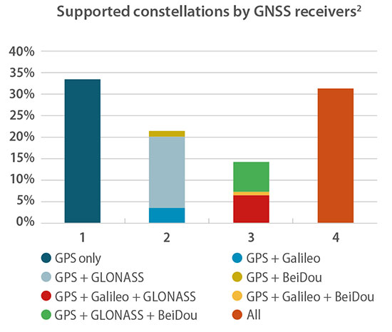
Chart: GSA report
In the fine print on page 20 of the report lay clarification for my consternation. “For the analysis, each device is weighted equally, regardless of whether it is a chipset or receiver and no matter what its sales volume is. The results should therefore be interpreted as the split of constellation support in manufacturers’ offerings, rather than what is in use by end users.”
Of the roughly 500 chipsets and modules tallied by the GSA, 30 percent of those models are GPS-only. That’s a number of quite a different color. See the chart for fuller information.
Better minds than this can take a stab at how many devices in the hands end users on this day are still GPS-only. I’d put it above 50 percent.
The writing’s on the wall for the GPS-only artifact, but a good many of those veterans are still out there, working hard in the marketplace. Their reign as the majority may be limited, especially with the rising global tide of multi-constellation smartphones, but let’s honor them one last time before consigning them to the museum.
The GSA’s report, by the way, is a remarkably good and valuable read. No one can know it all, but this slim volume packs a remarkable and essential density of key facts, trends, issues, markets and more.
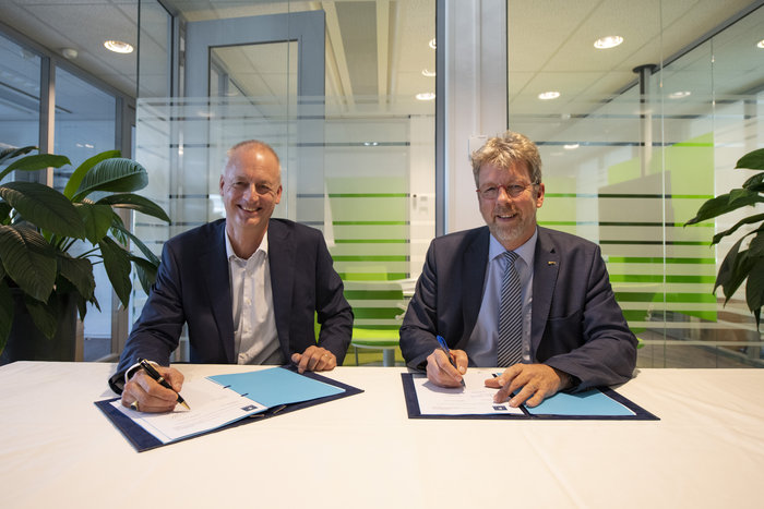
The European Space Agency has awarded a new framework contract and two new work orders to Thales Alenia Space in France to upgrade the Galileo Mission Segment, the element of the worldwide Galileo ground segment dedicated to delivering navigation services. Included are upgrades to the Galileo Security Monitoring Centre (GSMC) near Paris, and implementation of a second GSMC in Spain, near Madrid.
ESA Director of Navigation Paul Verhoef signed the contract with Thales Alenia Space Senior Vice President of Sales Martin van Schaik on Oct. 17 at ESA’s ESTEC technical centre in Noordwijk, the Netherlands.
“Galileo has already proven to be the highest performing satellite navigation system in the world, even before the constellation is complete,” Verhoef said. “This achievement is the result of the close collaboration between the public sector — the European Commission, the European GNSS Agency and ESA — and our industrial partners throughout Europe.
Contract signing: van Schaik (left) and Verhoef. (Photo: ESA)
“Today I am very happy to announce a continued relationship with Thales Alenia Space in one of the most complex parts of the system, namely the Ground Mission Segment, and thank them for their commitment to the programme.”
The constellation in orbit is only one element of the overall satellite navigation system – the tip of the Galileo iceberg. At the same time as the satellites were being built, tested and launched, a global ground segment was put in place.
Complex System
Establishing Galileo’s ground segment was among the most complex developments ever undertaken by ESA, having to fulfil strict levels of performance, security and safety.
In 2017, responsibility for operating the Galileo ground segment was passed to ESA’s partner organization, the European GNSS Agency (GSA). Nevertheless, ESA continues to be in charge of the maintenance, development and evolution of the ground segment, as well as the development of the space segment.
GSMC upgrade and construction. The first work order contracts Thales Alenia Space as prime contractor to undertake all necessary activities to upgrade the Galileo Mission Segment and the GSMC as part of Galileo’s exploitation phase.
This work includes upgrading Galileo’s system architecture to provide more accurate navigation products for broadcast by Galileo satellites, updating obsolescent elements in the current system, and improving operability linked to the provision of services and enhanced robustness.
This work order also includes the construction of additional uplink stations – tasked with uplinking the latest navigation messages to the Galileo constellation — at the existing Galileo ground station sites of Papeete in French Polynesia and Svalbard in Norway.
A new sensor station — providing a ground-based measurement of Galileo signal quality and precise satellite position — will also be installed at Wallis Island in the Pacific.
Galileo’s Nouméa ground station’s Sensor Station and Uplink Station. (Photo: ESA)
The work order will also augment the capabilities for implementation of the Public Regulated Service (PRS), the single most accurate and secure class of Galileo signals. Encrypted PRS signals will be made available only to authorised governmental users through approved national authorities.
Together, the two GSMCs will ensure the security of the overall Galileo system and manage PRS access and operations.
Security monitoring. The second work order contracts Thales Alenia Space as prime contractor to implement security monitoring functions for Galileo operational assets — including the control centres, service facilities and ground stations.
The integration, qualification, deployment and migration into operational services of the various upgraded segments will be undertaken over the next three years.
ESA has issued these work orders in its role of undertaking the design and development of future upgrades and the technical development of infrastructure as well as overseeing Galileo’s deployment, on behalf of the European Union, Galileo’s owner.
The second edition of the European GNSS Agency’s (GSA) GNSS User Technology Report has been published and is now available for free download, providing an exhaustive review of the latest GNSS trends and developments.
Since its launch in 2016, the GNSS User Technology Report has become the go-to-source for information on the dynamic, global GNSS technology industry.
The GNSS User Technology Report, a sister publication to the GSA’s GNSS Market Report, is published every two years and takes an in-depth look at the latest state-of-the-art GNSS receiver technology, along with providing expert analysis on the trends that will shape the global GNSS landscape in the coming years.
Three key segments
European GNSS Agency
Like the inaugural report in 2016, the second issue focuses on three key macro segments: mass market solutions; transport safety- and liability-critical solutions; and high precision, timing and asset management solutions.
The report opens with an overview of the latest developments and trends in GNSS, with a focus on the multi-constellation and multi-frequency that are driving new trends in the sector.
“With the GNSS User Technology Report, our aim is to provide everybody in the GNSS value chain with a comprehensive overview of the current landscape in the industry and to identify new trends so that stakeholders know in which direction the industry is moving,” GSA Executive Director Carlo des Dorides said.
“The most important new trend identified in this issue is the rapid adoption of multiple frequencies, including for consumer devices, as evidenced by the market introduction of the first dual-frequency smartphone in May 2018,” des Dorides said.
Editor’s special section: Automation
The final section in this year’s report — the “Editor’s special” section — is dedicated to automation and to the increasingly important role GNSS plays in a number of partially — or fully automated tasks and functions. The most publicised examples of these are found in the transport domain — driverless cars, autonomous vessels and drones but, as the report notes, GNSS-based automation applications go well beyond transport.
The analysis of GNSS user technology trends in the report is supported by testimonials from key suppliers of receiver technology, including: Broadcom, Javad, Kongsberg, Leica, Maxim Integrated, Meinberg, NovAtel, Orolia-Spectracom, Qualcomm, Septentrio, STMicroelectronics, Thales, Trimble and u-blox.
In addition, the report includes highlights from around 20 ongoing research projects from the Horizon 2020 and Fundamental Elements programmes, aiming at the development of GNSS receiver technology.
The full GNSS User Technology Report 2018 is available for download here.
GNSS User Technology Report 2018 Highlights
All global and regional GNSS constellations are developing, modernising and innovating, with more than 100 GNSS satellites now available over our heads.
The vast majority of current receivers are multi-constellation, and the most popular way to provide multi-constellation support is to cover all available constellations. Today only around 30% of receivers use GPS only.
In the mass market domain, we are seeing a divide between chipsets optimised for entry-level internet of things (IoT) products, where energy per fix is the primary driver, and high end, where the industry is innovating to propose enhanced positioning performance.
The need for accuracy in the mass market is initiating new solutions, including ones based on Android GNSS raw measurements or, more significantly, using multi-frequency signals.
The frequencies supported across all application areas range from single L1/E1 to 4 frequencies in the professional segment. The dual frequency solution showing the most growth is L1/E1 and L5/E5, however the legacy L1/E1 and L2 are still being used.
Growing interest has been observed in PPP and RTK services proposed by private industry and public system operators, leading to new PPP/RTK concepts aiming to address a wide customer base beyond high precision.
The need to ensure both safety and security of PNT solutions is being highlighted by all solution providers, particularly in systems where humans are out of the control loop, such as in autonomous vessels, cars or drones.
Precision agriculture depends on the precise positioning of augmented GNSS. In Europe, this augmentation is provided by the European Geostationary Navigation Overlay Service (EGNOS).
Although EGNOS is widely available in Europe, coverage is lacking in remote and rural areas.
To help fill the needs of farms in these areas, the Horizon 2020 AUDITOR project, funded by the European GNSS Agency (GSA), is developing a ground-based GNSS augmentation system that will deliver high-performance and cost-efficient services and applications for the agriculture industry.
“The purpose of this project is to develop an improved GNSS ground-based augmentation system using modern and proven algorithms in highly configurable, cost-effect receivers,” said Project Coordinator Esther Lopez. “As a result, AUDITOR will enable cost-effective precision agriculture services for farmers, especially those with small and mid-sized farms in areas where EGNOS availability is limited.”
The AUDITOR system is based on a radio frequency (RF) dual-band multi-constellation GNSS front-end and an embedded digital processing platform. The front-end receiver acquires the GNSS signals and embeds all analog and digital hardware required to convert the RF signal to digital samples.
The digital processing platform then converts and customizes the signals for the AUDITOR systems. The system serves as the basis for providing higher level services for the end user via cloud-based web and mobile applications.
Autonomous Future. With AUDITOR applications, farmers will be able to accurately measure spatial variability in soils and crops. Yield maps will allow farmers to precisely apply fertilizer, water and pesticides, reducing production costs and environmental impact.
AUDITOR’s high-accuracy positioning will also enable the use of autonomous mobile robotic units for identifying weeds, pests and diseases, GSA said.
“Producing precise maps of the soil and crops, as well as the spatially varying application of fertilizer that these maps enable, is completely dependent on the availability of an augmented GNSS signal,” Lopez said. “Thanks to AUDITOR, even areas in Eastern and Southern Europe that once were unable to get the required precise GNSS signal can reap the benefits of precision agriculture.”
With the ever-increasing requirement for augmented yield and profitability and energy and cost savings, the future of farming is precision agriculture. By focusing on providing the augmentation needed to enable existing precision agriculture applications in Europe alone, Lopez is confident that AUDITOR will be well-positioned to compete on the market.
The European GNSS Agency (GSA) has issued a request for information (RFI) in preparation for the procurement of EGNOS geostationary navigation payload services.
The EGNOS space segment is provided by commercial satellite operators on the basis of service contracts. The GEO-1, GEO-2 and GEO-3 service contracts now cover the EGNOS space segment needs, and the GEO-1 and GEO-2 services will be the first of these to end, GSA reported. The GEO-1 and GEO-2 services will be replaced by new contracts, GEO-4 and GEO-5.
GSA is planning how it will replace the services delivered by the GEO-1 and GEO-2 satellites, and it’s issuing the RFI to collect information about opportunities to embark navigation payloads on board GEO satellites launched in a suitable time frame.
According to GSA, the results of the RFI will also be used to determine the best approach for the procurement of the payload services, which may be either procured at the same time or separately. It will help GSA define the tender specifications and decide on the most appropriate time to launch invitations to tender.
In addition, GSA aims to obtain information from owners of geostationary satellites that will be available for operational service from 2021 to 2027 and able to embark a navigation payload. The agency is specifically seeking information on future satellite plans and the possibility to embark SBAS payloads in due time to ensure an operational start date from 2021 to 2027.
The RFI will also request information service availability and long-term payload reliability; the process for EGNOS payload procurement, in-orbit testing and commissioning; information on the locations of the potential hosting sites for the EGNOS radio frequency uplink stations; and, finally, information on contractual arrangements, the payment scheme, and cost estimates, GSA added.
Answers to the RFI should be sent electronically to [email protected] by Aug. 31.
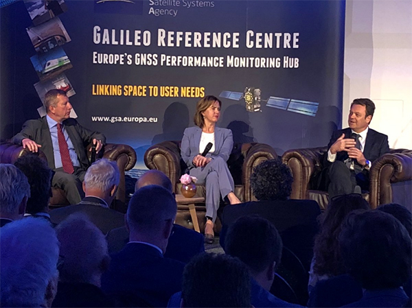
The Galileo Reference Centre (GRC), the new state-of-the-art performance monitoring hub for the European Union’s global satellite navigation system, was officially inaugurated May 16 in Noordwijk, the Netherlands.
The ceremony was presided by Dutch Minister of Infrastructure and Water Management Cora van Nieuwenhuizen and European GNSS Agency (GSA) Executive Director Carlo des Dorides, among others.
GSA Executive Director Carlo des Dorides (right), Dutch Minister for Infrastructure and Water Management Cora van Nieuwenhuizen, and DG GROW Deputy Director-General Pierre Delsaux at GRC inauguration. (Photo: GSA)
“The Galileo Reference Centre is a state of the art facility that underpins Galileo service provision,” des Dorides said. “The GRC will be instrumental in monitoring the performance of the system and of the service operator, ensuring that users benefit from the most reliable satellite data and, at the same time, disclosing new service potential.”
“I am proud of the fact that the Galileo Reference Centre is located in the Netherlands,” van Nieuwenhuizen said. “The data provided by Galileo will enable us to navigate with an accuracy to within 20 centimeters. In rescue operations, this sharp reduction in response time is going to save human lives.”
Independent monitoring ensures quality for users
The GRC is a cornerstone of service provision for Europe’s Galileo satellite constellation and plays an important role in Galileo’s operations, providing the GSA with an independent means of evaluating the quality of the signals in space and the performance of the Galileo Service Operator (GSOp). In so doing, it helps ensure the provision of high-quality satellite data so users can better rely on and benefit from Galileo.
Managed by the GSA, the GRC is comprised of a core facility in Noordwijk and contributions from EU Member States, Norway and Switzerland. From the core facility, the GRC generates performance evaluation products and reports using data collected in-house and through cooperation with Member States. The Centre also performs dedicated campaign-based analyses to support investigation of any service performance issues and reports on its findings.
In this two-pillar approach, the GRC benefits from and contributes to maintaining long-term competence and expertise at the Member State level, and actively integrates contributions from the EU Member States, Norway and Switzerland to support daily operations and specific campaigns.
The GSA has established agreements with two beneficiaries, one led by the French Space Agency (CNES) and the other by the Netherlands Aerospace Centre (NLR), and 23 organizations from 14 different countries. Member State contributions include data from networks of reference stations and campaigns using vehicles, vessels and airplanes, and reference products.
The GRC is fully independent of the system and the Galileo Service Operator with respect to its operations.
Since June 2017, GRC operations were hosted and operated from a temporary facility at ESTEC, the neighbouring ESA technical centre, which was instrumental in the swift ramp-up of competences. In April the GRC moved to its new home.
Earlier in May, the GRC hosted representatives from US GPS, Russian Glonass, Chinese BeiDou, Japanese QIS and Galileo to discuss the creation of an authoritative international GNSS monitoring and assessment system to benchmark the performance of available GNSS. The meeting was organised through the International GNSS Monitoring and Assessment Task Force of the United Nations Office of Outer Space Affairs (UNOOSA), International Committee on GNSS (ICG).
Spirent Communications plc is working with the European Commission’s Joint Research Centre (JRC) to help implement the eCall system, which is required in new cars sold in Europe starting in April.
Experts from the JRC have been working with Spirent GNSS test equipment during the European GNSS Agency (GSA) eCall test campaign. The campaign aims to pre-test eCall in-vehicle modules and evaluate their compatibility with the positioning services provided by Galileo and the European Geostationary Navigation Overlay Service (EGNOS) in accordance with the test procedures established by the regulation.
As the eCall initiative goes live this month, the GSA launched a test initiative to support eCall device manufacturers in their preparation for type approval. In safety-critical situations, eCall must be as accurate as possible, so defining and conducting proper test procedures is imperative.
Spirent is cooperating with the JRC to develop its own eCall test solution. “Working with JRC enabled us to develop better tests to verify that eCall devices are working properly,” said Steve Hickling, product director for Spirent’s positioning business.
When a collision occurs, an eCall-equipped car automatically calls the nearest emergency centre. Even if no passenger is able to speak – such as because of injuries — a “minimum set of data” is sent, which includes the exact location of the crash site. eCall is expected to significantly reduce emergency service response times, leading to lives saved and injuries reduced.
The JRC used a Spirent GSS9000 simulator to assess eCall devices’s capability to support the reception and processing of the Galileo and EGNOS signals. Using feedback from the JRC, Spirent has developed an eCall Test Suite for its automation solution, PT TestBench.
Tested with various eCall devices, the eCall Test Suite is available for eCall device manufacturers and include, among others, positioning accuracy, time to first fix, GNSS receiver sensitivity and reacquisition performance.
The European GNSS Agency (GSA) has officially launched the equipment for dual frequency Galileo, GPS and EGNOS project (EDG²E) with a consortium led by Thales. The four-year project intends to develop a dual-frequency multi-constellation receiver, enabling enhanced navigation capabilities, support standardization and certification preparation, and facilitate the expected increase in air traffic, both in Europe and globally.
The prototype EDG²E receiver use GPS and Galileo signals as well as those from the European SBAS multi-constellation EGNOS. The project aims to achieve a prototype demonstration by 2021. At the end of the EDG²E project, the first SBAS dual-frequency GPS+Galileo receivers for aviation will be ready for final development and use in the aviation sector and in other safety-critical applications. Fully achieved receivers are foreseen to be installed in commercial aircraft by 2025.
EGNOS, certified for use in aviation since February 2011, is developing its own next generation, called EGNOS V3, to further enhance performance by complementing both the EU Galileo and the US GPS satellite navigation constellations.
“EGNOS v3 will provide aviation users with an increased quality of services, better accuracy and extended coverage area among other key performance indicators” said Jean-Marc Pieplu, GSA head of the EGNOS Services Programme. “Fundamental Element Programme is a medium that supports development of terminals and antennae fostering use of E-GNSS in all domains. In this perspective,EDG²E is an important step for GSA as it will contribute to availability of high technology products on the aviation market, taking benefit of Dual Frequency Multi Constellation feature offered by EGNOS v3.”
The consortium includes Thales, Thales Alenia Space and ATR, as well as contributions from Dassault Aviation and the French Civil Aviation Authority.
Feature image courtesy of the European Space Agency (ESA).
The European GNSS Agency (GSA) in Prague, Czech Republic, has brought financial benefits to the country over the past five years — 1 billion crowns, according to a report by Czech Radio. The GSA is the only European-wide government agency sited in the country.
The GSA moved from Brussels, Belgium, to Prague in 2012.
The Prague agency – employing around 200 – deals with the programs that will turn the satellite network and signals into applications can be used by companies and the public at large.
One of the main benefits for the Czech Republic of having the headquarters in Prague is that the country is now on the doorstep for many Czech companies. The number of Czech firms are now receiving research and development funds linked to navigation services has increased ten-fold, with 44 Czech companies directly active in the navigation sector.
By Paul Verhoef
Director of the Galileo Programme and Navigation-related Activities,
European Space Agency
Paul Verhoef, director of the Galileo Programme. (Photo: ESA)
The European Space Agency (ESA) and the European GNSS Agency (GSA) are starting 2018 with the commissioning and In-Orbit Testing (IOT) of four new Galileo satellites.
This work is fairly routine for us as we have achieved the process successfully many times. But the impact of four new satellites for Galileo services is a different story.
This batch of satellites provided by OHB of Germany — 19, 20, 21 and 22 — will bring our constellation to 22 satellites. Together with the necessary ground segment delivered by Thales Alenia Space (TAS) and Airbus Defense and Space (ADS) and their many subcontractors throughout Europe, this will be providing availability to users anywhere in the world in order to achieve a high-quality position solution 99.8% of the time. “High quality” is hereby meant that the position dilution of precision (PDOP) will be smaller than 5, with our final accuracy for a full 24 FOC satellites operating at full potential being PDOP ~ 2.4.
This achievement will create a step change in the ability of service providers and equipment manufacturers to utilize the Galileo service. For all intents and purposes, it means the Galileo signal can always be relied upon to be there, and industry can sell products and design the power budget of devices based upon that fact.
Dual Frequency. The first mass-market GNSS receiver chip for smartphones and mobile devices that is able to utilize dual-frequency Galileo signals was released by Broadcom in September, able to employ both L1/E1 and L5/E5 signals. In 2018, dual-frequency technology like this will provide an order of magnitude increase in the performance of mobile device location-based services (LBS), especially in urban environments, and Broadcom advertises a 50% reduction in power consumption. The world of mobile-device LBS is going to change in 2018, and it will be due to the availability of Galileo.
It will not be the first time the partnership of ESA, the European Commission (EC) and the GSA has made a service available that has changed the nature of the marketplace. The GSA already has in service the ESA-designed EGNOS LPV200 aircraft approach service performing so well that countries like France have taken the decision to phase out the terrestrial Instrument Landing System that has burdened the capital expenditure budgets of airports in the past.
We have had discussions with several commercial organizations that are interested in building products around Galileo, and I am excited to see what they are going to come up with. With Galileo Initial Services the world had a new navigation signal to study and trial. In 2018 the world will have a new star to navigate by — well, a new constellation of 22 to 24 stars, I should say!
FOC. In the summer of 2018 we will launch the final part of the Galileo FOC constellation (geometrically speaking) with four more satellites taking us beyond the 24 needed for 100% coverage and minimum performance limitation from satellite geometry. The launch will also provide our first in-orbit spares, enabling us to plan for the end of life of our old validation phase satellites or otherwise supplement the constellation to improve performance.
What might we do with these in-orbit spares? Our first priority is to complete a constellation of 24 satellites in the correct orbits for minimum PDOP; as you know, a Fregat upper-stage malfunction left GSAT 0201 and 0202 in orbits too elliptical to correct fully, so the current plan is to complete the 24-satellite geometry. 0201 and 0202 are foreseen to be fully integrated in the Galileo operational system in 2018 following further testing and preparations, allowing us to have a 24+2 constellation with “hot back-up” from 0201 and 0202 contributing at around current GPS satellite levels of accuracy.
“It will not be the first — nor the last — time the partnership of ESA, the EC and the GSA has made a service available that has changed the nature of the marketplace.”
Of course, as is known to the community, the validation-phase satellite GSAT 0104 is down to single frequency, and we routinely monitor the health of all satellites. 0104 is the only satellite that has lost part of its function; designed-in redundancy has managed all other problems.
However, obviously we will be examining all options for deployment to ensure that the Galileo schedule is not impacted by in-orbit failures, and those we have experienced we have learned from and mitigated successfully without impacting the service.
The first two spares are not the end of our ability to maintain the constellation and our system performance. All four validation phase satellites will need to be replaced, and so the “Batch 3” satellite procurement will continue to regularly roll out satellites for replenishment of the constellation.
Enhancements. That won’t mean we will be resting on our laurels. In 2018 we also plan to release enhancements to the ground segment for Galileo, a process that will be a first as the system is already being operated by the GSA.
The process of managing an in-service upgrade program with the GSA is going to be new and challenging, but we have a strong engineering support team deployed as part of our working arrangement with the GSA to help ensure the process goes smoothly.
Of course, the need for GSA to be able to continue smooth operations imposes extra discipline and imposes on us a balance between stable operations and continued build-out of the infrastructure. We do not consider this to be a problem; on the contrary, the focus will be on robust operations and availability to the user.
Back at base (ESTEC in the Netherlands for Galileo and Toulouse, France, for EGNOS) we are full steam ahead on preparing the future. We are moving forward at considerable pace with our next-generation designs that develop new functionality for continuous service improvements.
Free PPP. Galileo was designed to broadcast a Commercial Service signal providing services such as precise point positioning to paying customers, but we are pleased to able to report that the EC has confirmed that this service will be provided for free by the European Union. In 2018/2019 the GSA will select the providers and get that unique, free service on the air.
In 2017 the EC confirmed the decision to implement the commercial service using E6-B with both encrypted and open components so all users could benefit for all frequency bands. Now, with the decision to make the service available free of charge, all users of Galileo, with the right type of receiver, will be able to achieve position fixes with an accuracy around 10 cm from Galileo’s first-generation constellation by 2020/2021.
The Galileo Public Regulated Service will also be a focus, with the EC soon to decide upon release dates for the first milestones on the service roadmap. The infrastructure and equipment to support a secure service is being put in place, and I can’t say more for security!
The next generation of European GNSS technology will include multi-constellation EGNOS, Galileo 2nd Generation (G2G) and a transition batch of satellites between the first and second generations to get the best technology proven in flight and working for Galileo users as soon as possible. G2G will reach its System Requirements Review stage in the first half of 2019. To be ready for that we are looking at:
clock technology and ensembles
inter satellite links
propulsion technology
flexible payloads and power allocation
5G telecoms networks standards and what we need to do ensure we provide the timing services those networks will need and new signals with time to first fix (TTFF) and power requirements for acquisition of signal that are compatible with 5G devices. Look out for a new pilot signal E1-D to move forward on this.
Open Service authentication and support for ARAIM (Advanced Receiver Autonomous Integrity Monitoring).
Finally, 2018 will see the first contract awards of the Navigation Innovation Support Programme. This is a programme specifically designed to encourage R&D, new concepts and new products and to ensure that 2018 is not the last time ESA with the EC and its industrial partners deploy a GNSS service for GSA to operate that changes the world.
The Railway High-Integrity Navigation Overlay System (RHINOS) work program explores candidate concepts for provision of the high integrity required for train positioning within a train-control system. GPS and Galileo plus satellite-based augmentation systems constitute the global reference infrastructure. In addition, local augmentation elements, advanced receiver autonomous integrity monitoring, and other trainboard sensors on can mitigate hazards due to environmental effects governing rail applications. RHINOS will be developed in cooperation with Stanford University researchers experienced in high-integrity aviation applications. The goal is moving beyond regional applications towards a global solution in the fast-growing train signalling market. RHINOS is financed by the European GNSS Agency and led by the Italian consortium RadioLabs, with partners Stanford University, Sogei, German Aerospace Center, University of Nottingham and University of Pardubice.