Europe’s fifth and sixth Galileo satellites — subject to complex salvage maneuvers following their launch in 2014 into incorrect orbits — will help to perform an ambitious year-long test of Einstein’s most famous theory.
Galileos 5 and 6 were launched together by a Soyuz rocket on August 22, 2014. But the faulty upper stage stranded them in elongated orbits that blocked their use for navigation.
ESA’s specialists moved into action and oversaw a demanding set of maneuvers to raise the low points of their orbits and make them more circular. “The satellites can now reliably operate their navigation payloads continuously, and the European Commission, with the support of ESA, is assessing their eventual operational use,” explained ESA’s senior satnav advisor Javier Ventura-Traveset. “In the meantime, the satellites have accidentally become extremely useful scientifically, as tools to test Einstein’s General Theory of Relativity by measuring more accurately than ever before the way that gravity affects the passing of time.”
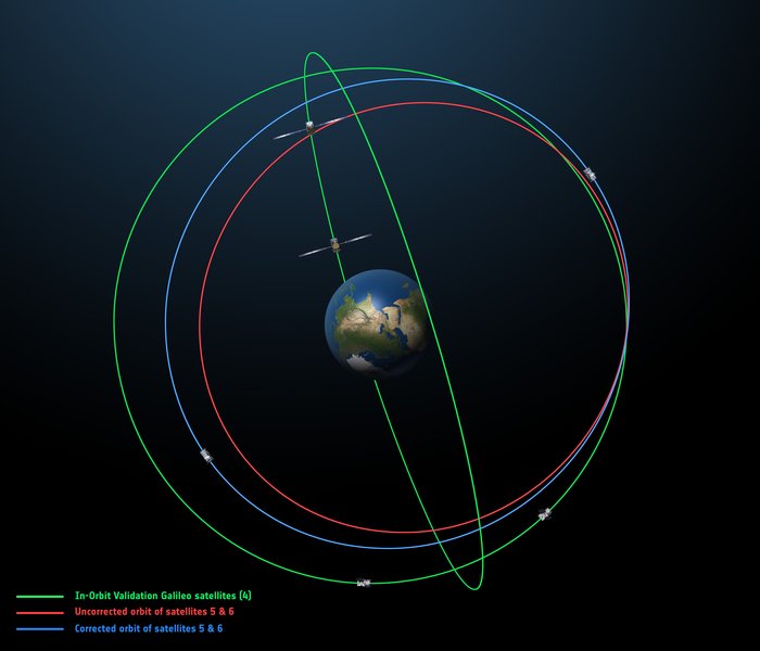
The original (in red) and corrected (in blue) orbits of the fifth and sixth Galileo satellites, along with that of the first four satellites (green).
Although the satellites’ orbits have been adjusted, they remain elliptical, with each satellite climbing and falling some 8500 km twice per day. It is those regular shifts in height, and therefore gravity levels, that are valuable to researchers.
Albert Einstein predicted a century ago that time would pass more slowly close to a massive object. It has been verified experimentally, most significantly in 1976 when a hydrogen maser atomic clock on Gravity Probe A was launched 10,000 km into space, confirming the prediction to within 140 parts in a million.
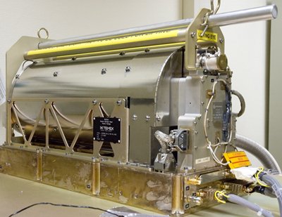
Passive hydrogen maser atomic clock of the type flown on Galileo, accurate to one second in three million years. (Photo: ESA)
Atomic clocks on navigation satellites have to take into account they run faster in orbit than on the ground — a few tenths of a microsecond per day, which would give us navigation errors of around 10 km per day.
“Now, for the first time since Gravity Probe A, we have the opportunity to improve the precision and confirm Einstein’s theory to a higher degree,” comments Javier.
This new effort takes advantage of the passive hydrogen maser atomic clock aboard each Galileo, the elongated orbits creating varying time dilation, and the continuous monitoring thanks to the global network of ground stations.
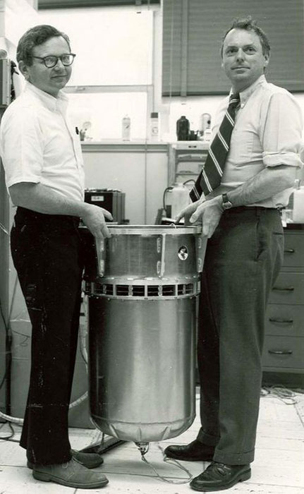
The Gravity Probe A payload of 1976, flown in a highly elliptic single orbit to measure the “gravitational redshift” of Einstein’s Theory of General Relativity more accurately than ever before, seen with its designers Robert Vessot and Martin Levine of the Smithsonian Astrophysical Observatory. The experiment compared a hydrogen maser clock on Earth with its replica in space as it ascended to about 10,000 km, and confirmed theoretical expectations to an accuracy of 0.02%. (ESA file photo)
“Moreover, while the Gravity Probe A experiment involved a single orbit of Earth, we will be able to monitor hundreds of orbits over the course of a year,” explained Javier. “This opens up the prospect of gradually refining our measurements by identifying and removing systematic errors. Eliminating those errors is actually one of the big challenges. For that we count on the support of Europe’s best experts plus precise tracking from the International Global Navigation Satellite System Service, along with tracking to centimeter accuracy by laser.”
The results are expected in about one year, projected to quadruple the accuracy on the Gravity Probe A results.
ESA’s forthcoming Atomic Clock Ensemble in Space experiment, planned to fly on the International Space Station in 2017, will go on to test Einstein’s theory down to 2–3 parts per million.
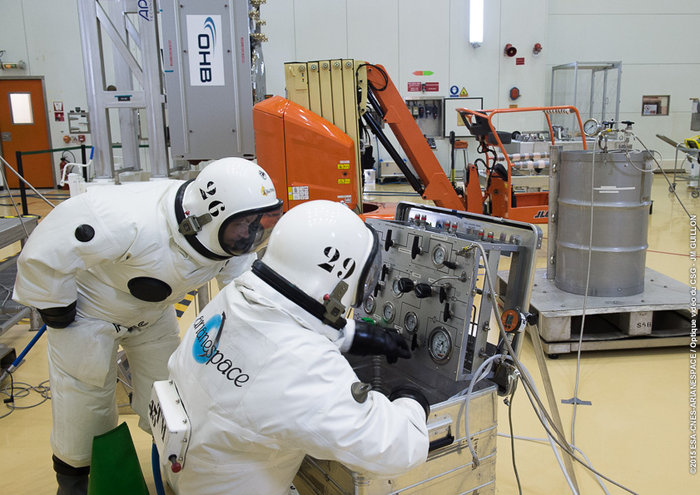
Europe’s ninth and tenth Galileo satellites being fueled by technicians in protective SCAPE suits within the Guiana Space Centre’s 3SB preparation building on Aug. 24. (Photo:ESA)
It has been a good late summer for the European Galileo programme. The latest launch on the night of 10 and 11 September has got the number of orbiting satellites in the EU’s GNSS constellation into double figures at last, and one-third of the way towards the ultimate target of 30.
The European Space Agency’s (ESA) press releases around the launch were positively euphoric, and there were many pictures of smiling ESA launch teams. And so there should be. The two new satellites (the fifth and sixth fully operational capability (FOC) versions named Alba and Oriana) will now inch their way towards their operational orbits and will soon be joined by two more satellites to be launched in December.
However, as we already know, one of the in-orbit validation (IOV) satellites (Sif) is not very well, having suffered a power failure in late May, and the first two FOC satellites (Doresa and Milena) ended up in the wrong orbit. At the considerable expense of a significant part of their fuel payloads, these two craft are now established in a more useful orbit and are the current subject of testing to determine the exact contribution they can make to the Galileo services.
The Commission and ESA are convinced that the outcome will be positive, with Doresa and Milena able to contribute to the network — or at least not degrade the network’s navigation performance. A final decision on if and/or how these two satellites integrate into the system will be made sometime next year.
In any case, they will be used for the provision of Galileo’s Search and Rescue services. And they are also to be made available for scientific research. One possible science area that has been discussed is to ‘repurpose’ the satellites to measure the slow down of time due to the Earth’s gravitational field as predicted by Einstein’s theory of relativity.
However, more worryingly, there are rumours of various glitches and performance issues with other in-orbit members of the constellation. Hopefully, they are just rumours; only time will tell.
Position Paper
Not surprisingly, those wanting to use the system are getting a tad frustrated. On Sept. 1, Galileo Services, a non-profit organisation involving 180 members including most of the active players in the EU GNSS industry, published a position paper entitled “Europe Must Succeed in the Global Navigation Market Race.”
The organisation’s aim is to foster an end-to-end vision of the Galileo system that can fully respond to user and market needs. The paper looks at the options to strengthen the competitiveness of the European GNSS downstream sector in the global market and calls for better coordination between the public and private sectors to develop new technologies, applications, services and industries in Europe as a key factor for success.
In particular, the paper stresses the necessity to urgently establish a European strategic plan to enhance Europe’s GNSS downstream industry’s competitiveness and to foster the uptake of the European GNSS, Galileo and the European Geostationary Navigation Overlay Service (EGNOS), with the aim to corner 33 percent of the global GNSS downstream market for Europe by 2025.
Galileo Services argues that unless an effective and long-term strategy is in place during the Galileo early services exploitation phase — from 2016, the current official start date for services — the window of opportunity for European industry will be closed. Europe’s goal of achieving GNSS autonomy is also at risk. The paper warns that Galileo is just one of three new GNSS solutions, along with the Russian GLONASS and Chinese BeiDou, that are complementing the U.S.’s GPS — and most applications do not require four GNSS constellations.
The target of European autonomy will be achieved if and only if Galileo is widely used with equipment designed and manufactured in Europe, as well as applications and services developed in Europe, concludes the paper.
More R&D Support
Part of the strategy should be enhanced support for EU GNSS technologies and applications. The European GNSS Agency (GSA) has just launched a new research support channel for GNSS chipset and receiver technologies in Europe.
The Fundamental Elements programme has a projected budget of EUR 100 million over the period 2015 to 2020 and is part, says the GSA, of an overall strategy of market uptake initiatives in accordance with EU regulations. “For the first time, EU regulation provides a financing tool for the market uptake of European GNSS chipsets and receivers,” said GSA Executive Director Carlo des Dorides in launching the new programme.
The Fundamental Elements programme complements the EU’s current Horizon 2020 research programme that focuses on adoption of Galileo and EGNOS via content and application development.
Two types of financing will be available via the Fundamental Elements programme: grants and procurement. Grants will be provided to cover up to 70 percent of funding requirements for a project, and intellectual property rights will stay with the beneficiary under the condition that the developed product is actively commercialised.
Procurement (at 100 percent funding) will be used only in cases where keeping intellectual property rights allow for the better fulfilment of the programme’s overall objectives. For example, by licensing it to different potential manufacturers rather than creating a monopoly supplier.
Meanwhile, EGNOS Continues
Of course, one EU GNSS, EGNOS, is operational. The GSA proudly announced that after extensive testing, the latest space segment — the SES-5 GEO satellite — is now fully functional. This will ensure the long-term service of EGNOS until at least 2026 and enable a range of performance improvements, including greater stability during periods of high ionospheric activity.
The SES-5 is a first step in the complete renewal of the EGNOS Space Segment, including the transition to dual-frequency, multi-constellation services. The renewal will be completed by the introduction of the ASTRA-5B signals and the procurement of a new EGNOS payload, both planned for 2016.
In parallel, the GSA and ESA have met formally to launch activities to develop the system further following the signing of a working agreement for EGNOS in July. Under the agreement, ESA will be responsible for the development and procurement of future EGNOS evolutions, such as the forthcoming release (V2.4.2), and a new generation of the EGNOS system (V3).
One of the annual gatherings of the whole European GNSS value chain will take place in October in Berlin with the Satellite Masters conference and awards ceremony. We can be sure that comforting words will be spoken by persons from the Commission, the GSA and ESA about their future plans and present progress. But the real buzz of this event is from the showcase of new ideas and applications for Galileo and EGNOS from pretty much every corner of Europe and beyond.
Despite the uncertainties expressed by some big industrial players, and slow progress in establishing the actual infrastructure, there is still an entrepreneurial enthusiasm from the ‘small guys’ to get involved in this space-based business.
I have attended these events for a few years now. One of the most enthusiastic winners of recent years is JOHAN, a sports application named after renowned Dutch soccer player and now sport commentator Johan Cruyff.
The application is the brainchild of Dutch graduate Jelle Reichert, whom I first met when he won the 2013 European Satellite Navigation Competition with this innovative EGNOS-enhanced tracking idea. “We are now operational with our first four clients! And in a final testing phase we are making the system ready for a commercial launch at the beginning of 2016,” he tells me. “We also just have an investor on board, which allows us to hire personnel and take the final steps to become really commercially ready.”
In just 18 months, Jelle’s idea has been brought into life with support from GSA and ESA. The JOHAN sports tracker and application helps improve teams by monitoring on-field performance. The system’s small, lightweight trackers, or pebbles, use GNSS technology such as EGNOS to ensure reliability and precision.
The trackers are small and light so they can fit into training vests worn by players across a variety of field sports, though early adopters have all been football teams so far. The trackers measure location, speed, distance, acceleration and orientation statistics, which are then visualized in an online data platform for coaches and players. This allows coaches to monitor workload and performance, and get tactical information and event analysis and ensure players’ strengths are used to the whole team’s advantage. Players can spot weaknesses and improve their individual game over time.
“You can see who is training too hard and who has a higher chance of injury, as well as who is strong in which performance aspects, such as endurance, sprint, agility or recovery,” explains Jelle.
I look forward to hearing about lots more grassroots GNSS innovation in Berlin.
And Finally … An Out-of-This-World App?
Take me to the moon! And why not, indeed? It appears that Galileo could be a vital part of an interplanetary navigation system. Or at least it could help (with GPS) spacecraft to routinely navigate to the moon.
A paper in Acta Astronautica highlights the strict requirements in terms of performance, flexibility and cost for all the spacecraft subsystems required to navigate to the moon. GNSS could introduce an easier way to provide an autonomous orbit determination system using an on-board GNSS receiver. While GNSS receivers have already been used successfully to pilot craft in Low Earth Orbit (LEO), their use for very High Earth Orbit (HEO) up to and including the Moon is an active research area.
The study from researchers at the Swiss Federal Institute of Technology in Lausanne (EPFL) made use of the Spirent GSS8000 multi-GNSS constellation simulator, which supports simultaneously the GPS and Galileo systems with L1, L5, E1 and E5 frequency bands. It showed that GNSS signals can be tracked up to the Moon’s surface, but would need new, more sensitive GNSS receiver technology. The paper describes a possible navigation solution that uses a double constellation GPS-Galileo receiver aided by an on-board orbital filter system to improve the accuracy of the navigation solution and achieve the required sensitivity. Without the filter, position error below 700 metres is possible, but the orbital filter increases the position accuracy to within about 100 metres.
Vincenzo Capuano from the EPFL team tells me that a further paper on the use of an GPS L1 C/A based orbital filter for Moon transfer orbits will be published soon, which also shows an achievable accuracy of a few hundred meters. So who needs expensive tracking stations for a flight to the moon?
But the work also has a very practical down-to-Earth application. The EPFL team is developing more sensitive GNSS receivers to pick up these weak signals, and the new receivers could find applications on Earth where current receivers often struggle to get a location, such as inside buildings or in built-up areas, where signals are weak.
The Galileo Control Centre in Oberpfaffenhofen, Germany, monitors and controls the constellation with a high degree of automation. (Photo: ESA)
News courtesy of the European Space Agency
Europe’s latest pair of Galileo satellites has passed its initial check out in space, allowing control to be handed over to the main control centre and join the growing fleet.
“This was a beautifully smooth start to the mission,” said ESA mission director, Richard Lumb. “From liftoff through to handover to the constellation operator and beyond, this has been a textbook performance not only of the satellites but also for all the operations and manufacturer teams on the ground.”
Galileos 9 and 10 were launched on Sept. 11. Their individual lives began within four hours, as they separated from their rocket’s final stage, overseen from ESA’s ESOC operations centre in Darmstadt, Germany. Days of round-the-clock effort followed, to bring the satellites to life, beginning with closely monitoring the unfolding of their solar wings and their pointing towards the Sun.
The various satellite elements were methodically switched on, their health checked and readied for work. Liviu Stefanov, an ESA flight director, described the process as “one of the smoothest yet.” The satellites fired their thrusters to drift towards their target orbital positions at around 23,222 km altitude — helped along in this case by a near-perfect orbital injection to begin with.
Firings will resume around the end of October to stop the drift and achieve fine positioning in orbit, guided by ESOC’s specialist flight dynamics team.
The accuracy of the Galileo system relies on the orbital position of its satellites being fixed to a very high level of precision.
Once on their way, the satellites were handed over on 19 and 20 September, respectively, to the Galileo Control Centre in Oberpfaffenhofen, Germany managed by SpaceOpal.
The team of engineers from ESA and France’s CNES space agency are preparing for the next launch, scheduled for December. The early phase for Galileos 11 and 12 will be overseen from CNES in Toulouse, France, which alternates with ESOC as hosts.
The navigation payloads on Galileos 9 and 10 still need to undergo detailed testing, led from ESA’s Redu centre in Belgium with the support of both Oberpfaffenhofen and the second Galileo Control Centre in Fucino, Italy, which has oversight of Galileo’s navigation mission.
This phase ensures the latest satellites’ navigation and search and rescue payloads are operating normally, giving them a clean bill of health before they can join the Galileo constellation.
The European Space Agency (ESA) on June 23 successfully launched its Sentinel-2A satellite, the second satellite to be launched in Europe’s Copernicus environment monitoring program. Above is a video of the Sentinel 2A lift-off.
“We are very pleased to have such a talented new player join the team in watching Earth from space,” said Suzette Kimball, acting U.S. Geological Survey (USGS) director. “The aptly named Sentinel mission will help sharpen our focus on changes in Earth systems and contribute further insight to a great many global challenges at international to local scales, including food security, forest and wildlife conservation, and disaster response.”
NASA has published a comparison of Sentinel-2A and Landsat bandwidths.
Sentinel-2 imagery is expected to supply valuable parallels and counterparts to Landsat imagery provided by the United States. Before Sentinel-2A launched, USGS and ESA staff worked together at length to ensure that Sentinel-2 data would be as compatible as possible with Landsat data.
First launched by NASA in 1972, the Landsat series of satellites has produced the longest, continuous record of Earth’s land surface as seen from space. Landsat images have been used by scientists and resource managers to monitor water quality, glacier recession, coral reef health, land use change, deforestation rates, and population growth.
Landsat is a joint effort of USGS and NASA. NASA develops remote-sensing instruments and spacecraft, launches the satellites, and validates their performance. USGS develops the associated ground systems, then takes ownership and operates the satellites (since 2000), as well as managing data reception, archiving, and distribution. Landsat data were made available to all users free of charge under a policy change by the U.S. Department of the Interior and USGS in late 2008.
Sentinel-2A in the gantry before launch.
“We are also pleased that a free and open data policy has been adopted for users of Sentinel data,” Kimball added. “Free, open access to Landsat and Sentinel-2 data together will create remarkable economic and scientific benefits for people around the globe.”
Designed as a two-satellite constellation — Sentinel-2A and -2B — the Sentinel-2 mission carries an innovative wide swath high-resolution multispectral imager with 13 spectral bands. However, it will not fully duplicate the Landsat data stream, which includes thermal measurements. Sentinel-1A, a satellite with radar-based instruments, was launched April 3, 2014.
Once it is fully operational following several months of on-orbit testing, Sentinel-2A alone could provide 10-day repeat coverage of Earth’s land areas. With Sentinel-2A data added to the eight-day coverage from Landsat 7/8 combined, users can look forward to better-than-weekly coverage at moderate resolution. Repeat coverage capabilities will further increase with the planned launch of a second Sentinel-2 satellite (Sentinel-2B) next year.
ESA BIC Bavaria, part of the European Space Agency’s Business Incubation Centre (BIC) program, is poised to expand its presence in the aerospace hotbed Bavaria with the opening of another branch office in Ottobrunn near Munich. The Bavarian state government — itself a longstanding ESA BIC partner and supporter — also hailed the program’s new partnership with Airbus Defence and Space at the Ludwig Bölkow Campus in Ottobrunn.
“The new ESA BIC Bavaria branch location in Ottobrunn will enable us to drive the creation of new start-ups based on the research endeavours pursued on-campus,” explained Ilse Aigner, Bavaria’s State Minister of Economics. “Smaller companies in particular have the ability to provide fresh, innovative ideas to Bavaria’s aerospace industry. Much of this sector’s supplier landscape also focuses on the midmarket, which makes these firms’ contributions all the more important.”
Airbus Defence and Space and the ESA BIC program expect their combined efforts to achieve another surge in the commercial use of space infrastructures and technologies.
“The aerospace hub of Ottobrunn and its newly constructed Ludwig Bölkow Campus offer an ideal setting for new companies to grow in collaboration with research and development. This new location promises to integrate Ottobrunn into the ESA BIC Bavaria’s outstanding partner program,” said Thomas Müller, member of the Executive Committee of Airbus Defence and Space and responsible for the Airbus site in Ottobrunn.
“The Ludwig Bölkow Campus is proud to figure amongst ESA’s Business Incubation Centres from now on,” added Alexander Mager, managing director of the Ludwig Bölkow Campus GmbH.
The ESA BIC program now offers start-up entrepreneurs extensive financial and technical support at 20 locations in eight countries: Belgium, France, Germany, Italy, the Netherlands, Portugal, Spain, and the UK.
“ESA’s incubation program has already helped to found 300 companies and is now supporting 100 new start-ups every year, making it the fastest-growing initiative of its kind in the space industry,” said ESA Director General Jean-Jacques Dordain, “and I am glad that the first one created was here in Bavaria with the strong support of the government and of the DLR.”
Anwendungszentrum GmbH Oberpfaffenhofen (AZO), which manages the ESA BIC Bavaria, has been responsible for 98 of these new foundations and the creation of more than 1,200 new jobs, which — along with its impressive network of partners — gives it a place of prominence among ESA’s incubation centers in Europe. Bavaria’s ESA BIC program works closely with the German Aerospace Center (DLR) and the Fraunhofer-Gesellschaft, Germany’s two largest research institutions. Further support is provided by the Wirtschaftsförderung Berchtesgadener Land (a local business-promotion association) and Bavaria’s two most financially sound savings banks, Sparkasse Nürnberg and Kreissparkasse München-Starnberg-Ebersberg.
Start-ups founded through the ESA BIC program benefit from a broad portfolio of space technologies and IP protection services, as well as from their cooperation with the various partners involved, according to ESA BIC Bavaria. “Europe’s space programs in satellite navigation (Galileo), Earth observation (Copernicus), and satellite communications also offer fantastic opportunities to established companies — and especially to those just getting their feet on the ground,” ESA BIC Bavaria said in a statement.
“Airbus Defence and Space is the first industrial aerospace company to join our incubation program,” said Thorsten Rudolph, CEO of AZO. “With its help, we’ll now be able to offer our incubatees and new companies an even wider range of support, from financing and R&D all the way to market launch.”
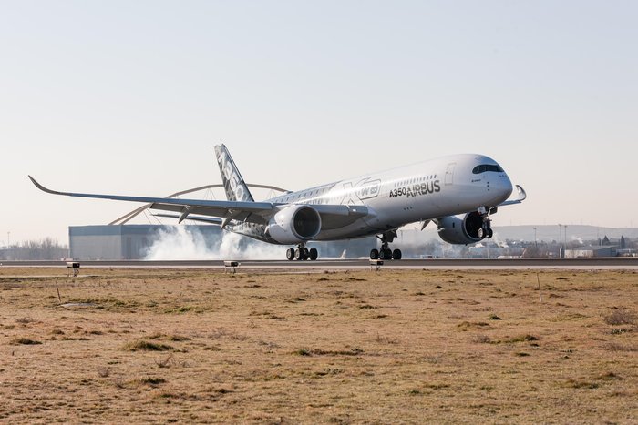
The twin-engine, wide-body Airbus A350 XWB, seen here at Spain’s Adolfo Suárez Madrid-Barajas airport, comes with EGNOS capability.
News by the European Space Agency
The EGNOS system, developed by the European Space Agency (ESA) for sharpening the accuracy of satnav across Europe, has been adopted by a growing number of airports to enable satellite-guided landing approaches. The new Airbus A350 airliner, currently entering service, comes fitted with it as standard.
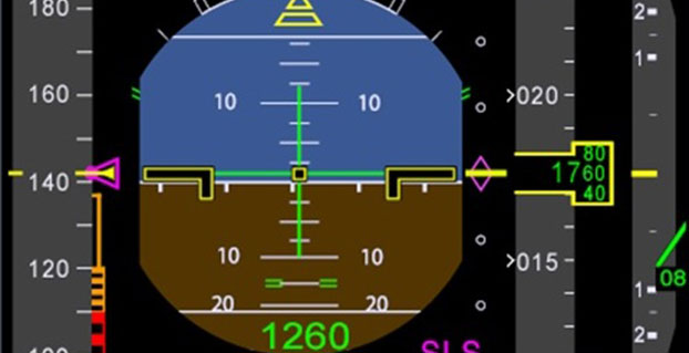
“For the first time on the A350 we have a new system called the Satellite Landing System,” explained Jean-Francois Bousquie, an Airbus flight-test engineer focused on avionics. “This allows pilots to perform precision landing approaches guided by EGNOS or its U.S. equivalent, WAAS, offering vertical guidance down to a minimum of 60 meters before the pilot sights the ground to make the go/no-go decision on the final landing descent.”
The A350’s Satellite Landing System allows pilots to perform precision-landing approaches guided by EGNOS or its U.S. equivalent, WAAS. The capability offers vertical landing guidance down to a minimum of 60 miles before the pilot sights the ground to make the go/no-go decision on the final landing descent.
The European Geostationary Navigation Overlay System, or EGNOS, can provide horizontal and vertical guidance to anywhere in Europe, without the need for any additional airport-hosted infrastructure. By using three geostationary satellites and a 40-strong network of ground stations, EGNOS improves the accuracy of GPS signals over European territory, while also providing continuous updates on their integrity.
The result is that the EGNOS-augmented signals are guaranteed to meet the extremely high performance standards set out by the International Civil Aviation Organisation standard, adapted for Europe by Eurocontrol, the European Organisation for the Safety of Air Navigation. The signals from space can therefore be relied on routinely for the safety-critical task of vertically guiding aircraft during landing approaches.
A total of 131 airports in Europe offer some 225 EGNOS-based approach procedures. By 2020, 582 landing procedures are expected across 20 European countries. The largest international airports use Instrument Landing System (ILS) infrastructure, with radio beams offering a truly precision landing capability, including the ability to autoland when visibility is at its worst.
But ILS is expensive to install and maintain, so smaller regional airports often forego it. The same is true of many new or expanding airports. Even with larger airports, in many cases only their busiest runways are equipped with ILS. So EGNOS offers a cost-effective way of safely increasing use of remaining runways, boosting the flexibility of any given airport.
“By reducing the value of the minima — the lowest safely guided altitude — for non-ILS runways, EGNOS increases the efficiency and safety of aircraft landings,” added Bousquie. “The take-up of EGNOS by European airports remains relatively low for now, but this should change over time. And with the A350, we are really designing for the long term — each aircraft will have a working life of 25 to 30 years.”
“Every qualified commercial airline pilot has been trained on ILS, to follow its radio beam,” Bousquie said. “So the Satellite Landing System works by having them follow the same type of cues as much as possible on a ILS ‘look-alike’ basis, employing all available navigation data including EGNOS.”
A pair of onboard Multi Mode Receivers manage the A350’s radio sensors, compute the deviations and ensure interface with display and guidance systems.
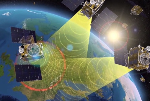
EGNOS is Europe’s first venture into satellite navigation. EGNOS broadcasts augmented information through a trio of geostationary satellites linked to a network of monitoring ground stations, to sharpen the accuracy and reliability of GPS signals across the continent. (artist’s concept: ESA)
News from the European Space Agency
The next decade’s aircraft pilots will be able to rely on enhanced, reliable satellite navigation signals on a seamless basis across much of the world, thanks to decisions made at the latest gathering of worldwide satnav augmentation system providers and experts.
The U.S. Wide Area Augmentation System (WAAS) and European Geostationary Navigation Overlay Service (EGNOS) are leading examples of satellite-based augmentation systems (SBAS) that apply additional ground stations and satellite transponders to sharpen the accuracy and reliability of existing satnav services across given geographical regions.
These performance enhancements permit satnav to be employed for safety-of-life services, especially aviation. Such systems are based on the U.S. GPS for now, but plans are being laid to move to a multi-constellation design employing Europe’s Galileo, China’s Beidou and Russia’s GLONASS satnav systems beyond 2020.
The 28th Satellite-based Augmentation Systems Interoperability Working Group (IWG), planning standardization of SBAS systems to come, was hosted at ESA’s ESTEC technical centre at Noordwijk, the Netherlands, on April 1-3.
The ESTEC facility in Noordwijk, The Netherlands. (Photo: ESA)
All participants unanimously endorsed the “message definition” for a new secondary SBAS channel — to be known as L5, along with the current L1 — for the planned second-generation SBAS systems, which will utilize dual-frequency multi-constellation signals.
Using dual frequencies greatly increases the accuracy of navigation systems, by allowing interference from the ionosphere — an electrically active outer layer of Earth’s atmosphere — to be largely subtracted from the final result.
“This definition is presented in what is called the Dual Frequency Multi-Constellation Definition document,” explained Didier Flament, representing ESA. “It represents the outcome of a four-year activity, which started at IWG 19 in Japan, back in 2010, coordinated between all IWG members under the technical leadership of ESA and French space agency CNES on the European side, and the Federal Aviation Authority (FAA) and Stanford University on the U.S. side.
“The formal IWG review loop for the document took six months to conclude, with this IWG 28 then allowing endorsements to be gathered by SBAS project managers, culminating in formal signatures to the document,” Flament said.
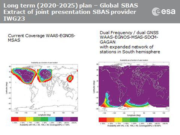
SBAS coverage for 2020: Comparing current worldwide SBAS coverage — based on WAAS, EGNOS and MSAS — to the situation envisaged for 2020–25: near-global coverage based on WAAS, EGNOS, MAAS, SDCM and GAGAN, with an expanded network of stations in the southern hemisphere, all based on a common dual-frequency/dual satnav standard being finalized by the SBAS Interoperability Working Group. (Image: ESA)
IWG members now intend to have this document accepted by the official international SBAS standardization bodies: the International Civil Aviation Organisation, the U.S. Radio Technical Commission for Aeronautics (RTCA) and the European Organisation for Civil Aviation Equipment.
“This next step is very important,” added Didier. “Not only for the coming 2016-22 implementation of the European EGNOS v3 but for implementation of other second generation SBAS in other regions of the world.”
The meeting also reported on the state of development of the other global SBAS systems. Along with the four operational systems — the U.S. WAAS, European EGNOS, Japan’s Multi-functional Satellite Augmentation System (MSAS) and India’s GPS-aided geo-augmented navigation or GPS and geo-augmented navigation system (GAGAN) — these comprise South Korea’s KASS, China’s Beidou SBAS, Russia’s System for Differential Corrections and Monitoring (SDCM) and the West African Agency for Aerial Navigation Safety in Africa and Madagascar (ASECNA) SBAS.
The follow-up IWG meeting will take place in October, hosted by the FAA in Washington, D.C., in conjunction with the next RTCA meeting.
Students still have time to join the ESA International Summer School on Global Navigation Satellite Systems, which will take place in Barcelona, Spain, at the end of August.
The 10-day course — lasting from the afternoon of Aug. 31 to the morning of Sept. 10 — will cover all aspects of satellite navigation, up to and including the creation of a satnav-based business.
Hosted by the University of Barcelona at the four-star Hotel Alimara, the Summer School is open to graduate students, PhDs and postdoctoral researchers, as well as young engineers and academics working within industry or agencies, aged 35 or younger.
Internationally renowned scientists and specialists will be giving lectures as well as overseeing practical exercises and lab work. Participants will receive a full-spectrum overview of satellite navigation, starting from the theoretical basis of the Global Navigation Satellite System (GNSS), its signals, the processing performed by signal receivers and how the position-navigation-time solution is worked out.
Discussion will also be made of threats to satnav systems, such as spoofing or jamming, and the countermeasures available against them, along with back-up navigation solutions for a GNSS-denied environment.
Practical exercises will include receiving the various satnav constellations now in orbit — including Europe’s eight-satellite Galileo, the foundation of the full system soon to come — to give course members direct, hands-on experience.
In addition, lectures will cover business aspects, including patents and intellectual property rights.
The main emphasis of the course will be the development of a group business project, building on an innovative idea to take in the planning of the product or service, its technical realization and finally its marketing to customers.
Register before the end of May to benefit from an early registration discount. The number of participants is limited to 50, on a first-come, first-served basis.
The ESA International Summer School is taking place in conjunction with the GNSS Summer School of the Joint Research Centre of the European Commission, and is organized by Universitat Politecnica de Catalunya (UPC) in cooperation with Stanford University in the US, the Institut Supérieur de l’Aeronautique et de l’Espace in France, Graz University of Technology in Austria and University FAF Munich in Germany.
The Coperinicus Masters Cup Photo: Anwendungszentrum GmbH
Copernicus Masters submissions of ideas, applications or business concepts involving innovative uses of Earth observation data are due by July 13. Along with cash prizes, the winners will gain access to an international network, corresponding data, start-up funding and other support valued at more than €300,000 ($322,444) total.
The amount of data produced by Copernicus, the European Earth observation program, and its Sentinel satellites opens the door to products and applications in a wide array of business sectors. The European Space Agency (ESA) and Anwendungszentrum GmbH Oberpfaffenhofen (AZO) have thus initiated the Copernicus Masters competition to aid visionary entrepreneurs in bringing their innovations to market.
“Start-ups and SMEs in particular stand to benefit from the virtually limitless scope of the data Copernicus provides,” said Prof Dr Volker Liebig, director of Earth observation programs and head of the European Space Research Institute (ESRIN), ESA. “The ideas submitted to previous editions of the Copernicus Masters have already demonstrated this to impressive effect, as has the constantly growing number of companies that are developing products and services based on Earth observation data in ESA’s business incubation program.”
These companies operate in a diverse range of fields, where they address subjects such as resource efficiency in agriculture, construction and renewable energy. The Copernicus Masters also is looking for new services and products in forward-thinking segments such as big data, cloud computing, crowdsourcing, data visualisation and mobile applications, to name a few.
In this year’s edition, prizes will be awarded in topic-specific challenges sponsored by partners, including: ESA, the German Aerospace Center (DLR), T-Systems International GmbH, Satellite Applications Catapult Ltd., Greece’s National Cadastre and Mapping Agency (NCMA), CloudEO AG and European Space Imaging GmbH. The new University Challenge specifically addresses students and research assistants around the world.
“We and our partners are offering the participants space for innovation in areas that are already shaping the future — the Internet of Things (IoT), Industry 4.0, smart cities and renewable energy, for example,” said Thorsten Rudolph, AZO managing director. “We want to support them in realising their creative solutions to these global challenges.”
Research and industry experts will select the winner of each challenge. The overall winner and 2015 Copernicus Master will receive, along with their challenge prize, €20,000 ($21,478) in cash and a satellite data package worth a further €60,000 ($64,434), which is being provided with the financial support of the European Commission.
“Taking part in the Copernicus Masters gave us the chance to make some key contacts and gather valuable feedback,” said John Smedegaard, a co-founder of Ceptu, which won the CloudEO Farming Challenge in 2014. “The whole process was a huge help in advancing our idea and developing it into a commercial product through our new start-up.”
All of the winners will be announced this fall and recognized at an awards ceremony.
For details on this year’s prizes, partners and terms of participation, view the event website.
One of the Honeywell Global Tracking ESA installations.
Honeywell’s Global Tracking solution has passed the final acceptance test for use on the European Space Agency’s (ESA) Galileo search and rescue program by demonstrating dramatically reduced emergency response times, Honeywell said.
Honeywell Global Tracking, part of Honeywell’s Scanning and Mobility business, is working in partnership with the Aerospace & Defense division of Capgemini, the prime contractor for the Galileo search and rescue program, to deliver a high-precision positioning system that is fully compatible with the international standard, which is known as the Cospas-Sarsat standard. Tests using the Honeywell system have proven that the time from beacon transmission to detection and processing has been reduced from several hours to a few minutes — often the difference between life and death in an emergency situation.
The international Cospas-Sarsat program is a satellite-based search and rescue distress alert detection and information distribution system, best known for detecting and locating emergency beacons activated by aircraft, ships and remotely located people in distress. Honeywell’s satellite tracking technology, which detects faint alerts sent by emergency beacons around the world using a combination of Doppler curves, noise reduction, and advanced signal processing, quickly calculates the exact location of the beacon and sends the results to the relevant Mission Control Centers in the region.
“Our Medium Earth Orbit-based search and rescue solution will lead to faster recovery missions and improved international search and rescue operations, and we’re pleased to partner with the European Space Agency to help execute on this important, life-saving system,” said David Sharratt, general manager, Honeywell Global Tracking. “With decades of experience developing this technology, Honeywell Global Tracking is the global leader of search and rescue solutions.”
“Up until now, Cospas-Sarsat has relied on satellites in low and high orbits, but medium orbits with satellites such as Galileo are better for search and rescue purposes; they combine a wide field of view with strong Doppler shift, making it more likely a distress signal is pinpointed promptly and accurately,” said Fermin Alvarez, ground station and fielding engineer with ESA. “Together with Honeywell, we are encouraged to see Galileo performing so strongly, thereby solidifying our ability to support precise and speedy search and rescue efforts.”
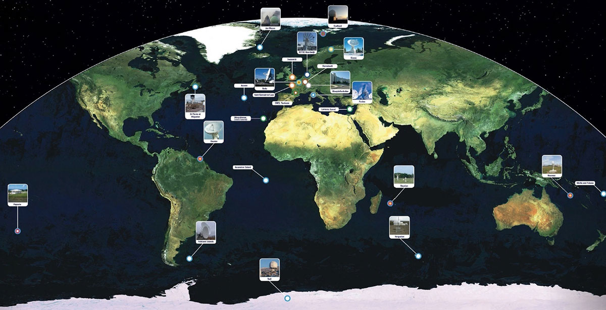
Galileo’s worldwide ground segment as of March 2013.
News from the European Space Agency
The worldwide Ground Mission Segment providing all Galileo navigation messages has completed a full-scale hardware and software migration to version V2.0, and is now fully operational again.
The Ground Mission Segment was turned off Jan. 26, allowing the migration to take place over the month of February. The following month was taken up with detailed checking by operations and system, concluding in a final “check point” on March 31 to validate the successful migration.
“The upgrade of the Galileo Ground Mission Segment from V1.2 to V2.0 has provided better overall performance and availability, along with improved robustness, security and operability,” explained Martin Hollreiser, overseeing mission segment development for ESA, with Thales Alenia Space France as prime contractor. “The overall outcome of our check point confirmed that the new GMS V2.0 migrated to the operational chain is a major improvement and no blocking issues were identified. An overall 25 percent performance improvement is confirmed.”
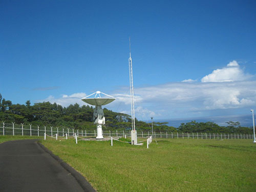
The new Papette Uplink Station in Tahiti, French Polynesia, used for uplinking navigation messages for rebroadcast to users from Galileo satellites.
“The process began with the upgrade of the infrastructure hardware at Galileo’s control centre in Fucino, Italy, and remote sites disconnected from the system to be monitored locally,” Hollreiser said. “This physical process was followed by a software update, and then a full-scale test campaign before handing back to operations and resuming the nominal Galileo mission on 6 March.
“Three new sensor stations (Kiruna, Ascension and Azores) — used to monitor the satellite navigation signals — were also added to the operations chain, as well as a new uplink station (Papeete) — used to uplink corrections incorporated in the navigation message to the satellites for broadcast to the users.”
Papette Uplink Station
Galileo is Europe’s satellite navigation system. The accuracy of its positioning fixes ultimately comes down to accurate satellite orbit determination and timing measurements and corrections that are precise down to a few billionths of a second. A satnav receiver determines its position by calculating the time it takes for signals to arrive from multiple satellites in space.
To keep those timings sufficiently precise, the entire Galileo system can be thought of as one gigantic planetary-scale clock, with the Ground Mission Segment at its core, determining the exact satellite orbits and synchronizing all the satellite and terrestrial elements of that clock: the relevant control center is linked to a global network of ground stations (sensor and uplink stations).
Operated by Telespazio, Fucino in central Italy is among the world’s largest satellite ground stations.
Each of the Galileo satellites in space carries multiple atomic clocks on board, which, although very accurate, drift slightly over time. So sensor stations on the ground extract measurements from the satellites’ signals and send these to the Galileo control center in Fucino, Italy. Here, processing takes place to derive very accurate satellite orbits and clock synchronization.
Any necessary corrections are then built into an updated navigation message that is then transmitted to the satellites via a set of five uplink stations. The satellites themselves then rebroadcast these corrections down to the users, to be automatically interpreted by receivers to maintain service precision.
Worldwide Galileo Ground Segment
During the upgrade, this regular updating of navigation messages no longer took place, so the accuracy of the Galileo signals to users slowly degraded. Users were informed of this process through a flag in the signal itself, as well as through the online Notice Advisory to Galileo Users (NAGU) notification process.
An updated NAGU has been issued to inform users that Galileo services are back. Right now the signals are being used for technical testing, with early services for the public projected for 2016.
“A further Galileo Ground Mission Segment update is foreseen for the end of this year,” Martin said. “But this time the upgrade should be executed in a seamless manner, with no interruption of services.”
Winners in the 30 categories will be announced in October.
The 2015 European Satellite Navigation Competition (ESNC), an international innovation competition that recognizes the best ideas in satellite navigation, will run from April 1 to June 30. Winners will be announced in October.
There are more than 20 regions participating, and the ESNC will award prizes worth a total of €1 million in 30 categories.
“Satellite navigation is an essential element of modern mobility and a key technology in particular, in the age of a data-driven economy. This is exactly where the European Satellite Navigation Competition comes in. It provides a public platform to the creative community in order to help promising ideas turn into solutions that are commercially mature and generate added value for society,” said Alexander Dobrindt, Germany’s Federal Minister of Transport and Digital Infrastructure (BMVI).
A jury of international research and industry experts will select the year’s overall champion among the winners of the categories, which comes with an additional €20,000 and access to a six-month incubation program in the champion’s preferred region.
International kick-off for the 2015 ESNC is scheduled for April 21 in London.
“As the Galileo satellite constellation continues to expand, efforts to promote corresponding applications will become increasingly important. This is where the ESNC is already playing a key role,” said Matthias Petschke, the European Commission’s director of satellite navigation programs. “As such, the Commission is definitely looking forward to seeing the creative and innovative GNSS-based applications submitted this year.”
This year’s special topic prizes are being sponsored by the European GNSS Agency (GSA), the European Space Agency (ESA), the German Aerospace Center (DLR) and the Ministry of Transport and Digital Infrastructure (BMVI) in cooperation with the German Federal Ministry for Economic Affairs and Energy (BMWi). Entrants may submit prototypes to the GNSS Living Lab Challenge, while the University Challenge specifically addresses students and research assistants.
“Those who enter the ESNC benefit in particular from our global network, which provides them with tailored support in developing their business concepts and bringing them to market,” said Thorsten Rudolph, managing director of Anwendungszentrum GmbH Oberpfaffenhofen.
All of the information on this year’s prizes, partners, and terms of participation is available at the ESNC website.