Six Galileo satellites are scheduled to be launched this year, European Space Agency (ESA) Director General Jean-Jacques Dordain said on January 16.
“The launch of six satellites is scheduled for 2015. The [European] Commission will determine the terms of the launches at the end of January,” Dordain said at a press briefing. The satellites will be put into orbit by Ariane 5 and Soyuz carrier rockets.
The Galileo project is jointly implemented by the European Union and the ESA.
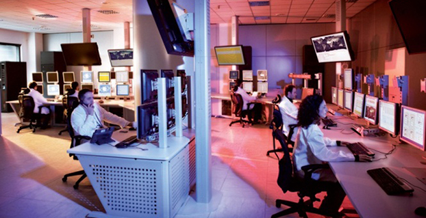
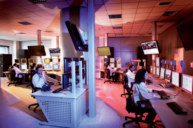
Operators of Galileo’s Ground Mission Segment at the Galileo Control Centre in Fucino, Italy. These operators oversee the navigation services of the Galileo constellation. Photo: Galileo
Galileo’s navigation messages will shortly stop being updated to enable the migration of a new release for Galileo’s ground mission segment, announced the European Space Agency.
Although the actual navigation signals will continue to be transmitted, the generation and uplink of the navigation message — which renews the contents of the signal — will be interrupted during the last week of January for about five weeks.
The accuracy of the navigation message received by users will slowly degrade, or in case of a reset in the satellite signal generator the message content will be dummy material. The users will be informed accordingly through a warning flag in the disseminated message, or through the online Notice Advisory to Galileo Users.
“The main benefits of this migration from V1.2 to V2.0 of the Galileo Ground Mission Segment are better overall performance and availability, increased robustness and improved operability,” explained ESA’s Martin Hollreiser, who is overseeing the mission segment’s development with Thales Alenia Space France as prime contractor. “The latter is achieved through enhanced operator interfaces, increased access to performance data and the automation of procedures.
“Various ‘non-conformances’ identified by operators over time have been fixed, while overall security has been further strengthened through treatment plans,” Hollreiser said. “This is in particular true for the Public Regulated Service, or PRS, the most secure Galileo class of signal. Finally, the number of Galileo Sensor Stations will increase from 12 to 15 worldwide and the number of Galileo Uplink Stations from four to five.
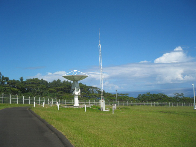
“The new Sensor Stations will be on Santa Maria in the Azores, Ascension Island in the mid-Atlantic and Kiruna in the Swedish Arctic. The additional Uplink Station will be on Papeete, in French Polynesia. Such system improvements have always been part of our planning since the contract began in 2011.”
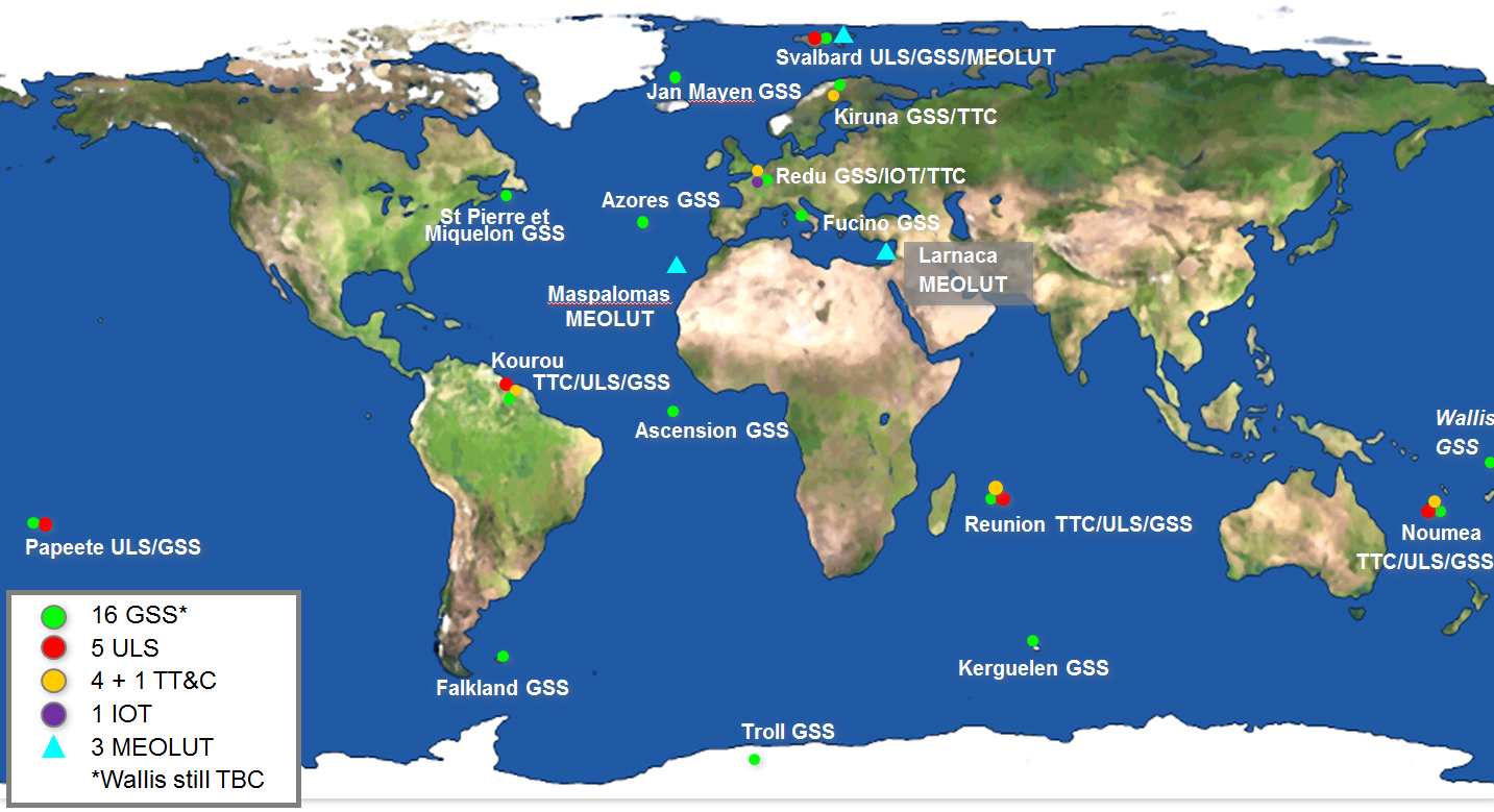
Galileo’s worldwide ground mission segment is one of the most complex developments ever undertaken by ESA, with twin European Galileo Control Centres and a network of sensor and uplink stations deployed on remote sites across the world. They are all interconnected via a robust satcoms realtime network.
While satellite control and housekeeping are performed by Galileo’s Ground Control Segment in Oberpfaffenhofen, Germany, the Ground Mission Segment that provides the navigation and timing services and related performances is operated from a separate centre in Fucino, Italy.
Galileo’s ground segment encompasses twin European Galileo Control Centers and uplink stations on remote sites across the world. They are all interconnected via a robust satcom network. It includes Galileo Sensor Stations (GSSs) to provide coverage for clock synchronization and orbit measurements; uplink Stations (ULSs) to uplink navigation and integrity data to the Galileo satellite navigation payloads for rebroadcast to users; Telemetry, Tracking and Command Stations (TT&Cs) to manage the satellite platforms; an In-Orbit Test (IOT) site at Redu for satellite payload testing and a trio of Medium-Earth Orbit Local User Terminals (MEOLUTs) for search and rescue activities.
A user’s satnav receiver needs signals from at least four satellites. It actually measures the time the signal takes to reach its antenna from the satellites, then converts time into distance to compute its spatial position as the intersection of the four resulting spheres. To reach sufficient level of precision, the time synchronization of the overall system clocks must stay accurate to a few billionths of a second, and any drift in satellite orbits must be corrected for.
This is the task of the Ground Mission Segment in the control center, which continuously receives signal measurements from the sensor stations around the world. Based on these measurements, it computes exact satellite orbits and time synchronization for the satellites’ onboard atomic clocks.
These corrections are incorporated into the ephemerides included in an updated navigation message, which is uplinked to the satellites for dissemination to the user. The updated ephemerides information in the navigation signal provides to the user receivers the information required to compute their exact position.
The new Papette Uplink Station in Tahiti, French Polynesia, used for uplinking navigation messages for rebroadcast to users from Galileo satellites. Photo: Galileo
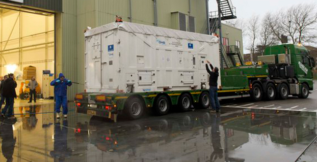
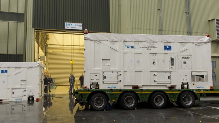
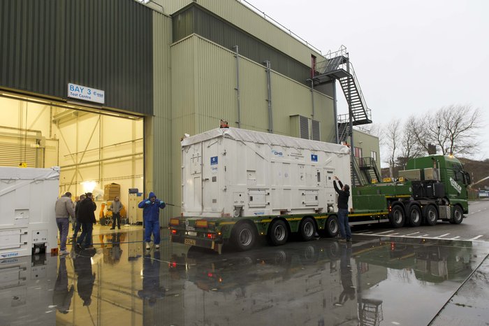
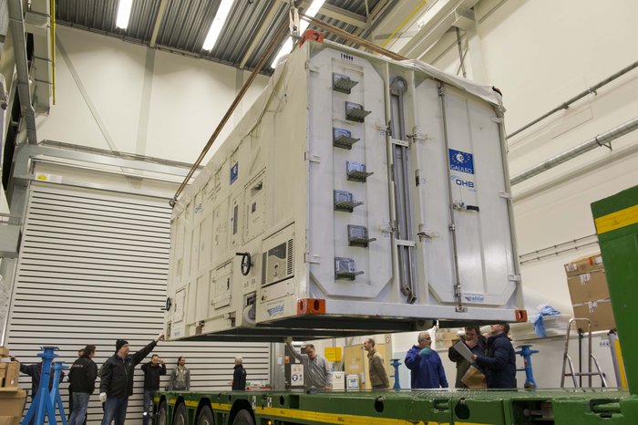
The latest Galileo satellite, formally known as FOC FM06, arrived at the ESTEC Test Centre in its protective container on Dec. 18, after traveling from OHB in Bremen, Germany. Photo: European Space Agency
The latest Galileo satellite has arrived at ESTEC, in the Netherlands, and is undergoing a full checkout to prove its readiness for space.
The satellite was carried by lorry from its manufacturer in Germany, cocooned within an environmentally controlled container. It arrived inside ESTEC’s cleanroom environment on Dec. 18. The container was then opened up to begin preparations for testing.
The first six Galileo satellites are already in orbit, launched in pairs in 2011, 2012 and August this year.
The last pair was delivered into the wrong orbit by a faulty upper stage, but the fifth satellite’s orbit has since been changed to allow checking of its navigation payload, which began at the end of November.
The sides and top of the Galileo satellite container were sprayed clean before it was taken inside the bay of the ESTEC Test Centre to keep any contamination from entering the pristine cleanroom. Photo: European Space Agency
Meanwhile, down on the ground, production of further satellites continues steadily, taking the Galileo series into double figures overall.
Following on from the first four In-Orbit Validation satellites, 22 of these Full Operational Capability satellites are being built by OHB in Bremen, Germany, with navigation payloads from SSTL in Guildford, UK.
Numbered Flight Model 6, or FM06 for short, this latest of the newer satellites is now reunited under the test centre’s roof with three others. FM03 and FM04 have completed their acceptance testing, culminating in the weeks-long thermal-vacuum test. Each satellite was subjected to the same vacuum and extreme temperature conditions experienced in orbit, as well as radio-frequency testing of their navigation payloads and antennas inside an anechoic chamber isolated from the external universe. This pair is now in storage in the centre pending the results of their concluding acceptance review.
The other satellite, FM05, recently ended its own thermal-vacuum trial. It is now being reconfigured for radio-frequency testing, planned to take place after the Christmas break. The latest unboxed Galileo satellite will undergo its own thermal–vacuum test in January.
ESTEC is an essential stop on the way to space for Galileo. It is equipped with all the facilities needed to simulate space conditions under a single roof, including an acoustic chamber, earthquake-strength shaker tables, and anechoic and vacuum chambers, along with a range of specialised measuring equipment.
Once ESTEC gives the satellites its stamp of quality then they are in principle ready to be flown to Europe’s Spaceport in Kourou, French Guiana. ESA and the European Commission are currently deciding on the launch schedule for these next Galileos.
The container containing the latest Galileo satellite, FOC FM06, was carefully hoisted off the lorry that carried it from OHB in Bremen, Germany. Its underside was then carefully cleaned before it was taken out of the bay into the cleanroom environment. Photo: European Space Agency
By Ugo Celestino, European Commission, Antonella Di Fazio, Telespazio SpA, Vicente José Giner Herrera, Ineco, Patrizio Vanni, ENAV SpA, and Francisco Javier Deblas, ESSP.
This article describes a live demonstration of an aviation application in Tunisia, to help the local aviation community in validating the use of the European Geostationary Navigation Overlay Service (EGNOS) to guide airplanes during landing operations. This activity constitutes the first complete experience of EGNOS Safety of Life (SoL) service for aviation approaches outside Europe. We present here the obtained results that are useful not only for Tunisia, but as a valuable case study for other countries outside Europe interested in using EGNOS in aviation.
EGNOS, operational since 2009, has a European regional coverage that could be quite easily extended to areas adjacent to European Union through the deployment of limited additional ground infrastructure elements, but sharing the same existing space segment and leveraging the other core ground infrastructure.
The European Commission has put in place a series of actions since 2006 to support the EGNOS service extension in neighbouring areas. The MEDiterranean follow-Up for EGNOS Adoption (MEDUSA) is an on-going European initiative related to EGNOS extension in the Euromed region, including North African and Middle East countries around the Mediterranean basin: Algeria, Egypt, Israel, Jordan, Lebanon, Libya, Morocco, Palestine, Syria, and Tunisia. MEDUSA runs a program of technical assistance action in these Euromed countries, in order to prepare them for an optimal adoption and exploitation of European GNSS services in their priority market segments.
The Mediterranean Extension of EGNOS
EGNOS is Europe’s first venture into satellite navigation and paves the way for Galileo, Europe’s independent global satellite navigation system currently under deployment.
EGNOS is a satellite-based augmentation system (SBAS), whose signal is compliant to the international SBAS interoperability standards: standards – MOPS (Minimum Operational Performance Standards) and ICAO SARPs (International Civil Aviation Organization Standard and Recommended Practices). In its current version (V2) it augments the open public service offered by the American Global Positioning System (GPS), by providing correction data that enables to improve GPS position accuracy, and provides integrity information about the GPS system (integrity information is fundamental for aeronautical applications like approaches). EGNOS is interoperable with the other equivalent regional systems. Today other SBASs are the U.S Wide Area Augmentation System (WAAS), the Japanese Multi-functional Satellite Augmentation System (MSAS), the Indian GPS Aided Geo Augmented Navigation (GAGAN) and the Russian System for Differential Correction and Monitoring (SDCM). The future version (V3) of EGNOS will augment Galileo signal as well.
Today EGNOS is operational, and available for use in aviation since 2011, giving opportunities for users to have more accurate and reliable positioning for enhancing existing applications, developing new applications and particularly the safety critical ones. Already more than 150 landing procedures are operational across Europe (some of them also in countries out of the European Union, such as Switzerland, Norway, Guernsey), with many others under development to reach 100 percent Approaches with Vertical Guidance (APV) coverage in the European instrumental runways as per ICAO recommendation.
EGNOS provides three services:
EGNOS Open Service (OS), launched in 2009, is delivered free of charge. It is open for use to anyone with an EGNOS-enabled receiver. This can be any receiver compatible with satellite-based augmentation systems. Being based on GPS, the EGNOS signal does not require major changes for receivers. Today, many mass market receivers available on the market are also EGNOS enabled. EGNOS OS is particularly suitable for mass market and some applications like surveying.
EGNOS Safety-of-life Service (SoL) is authorized for European civil aviation and operational since March 2011. EGNOS SoL delivers the integrity message providing the verification of the GPS system and timely warnings (within six seconds), when the system or its data should not be used for navigation. Since integrity relates to the trust that can be placed in the correctness of the location information supplied by GPS, thanks to this feature EGNOS is able to meet the demands of safety-critical applications in sectors such as aviation.
EGNOS Data Access Service (EDAS) launched in 2012, delivers a terrestrial commercial data service. It consists of a server that gets the data directly from EGNOS system and disseminates it via terrestrial networks in real time, within guaranteed maximum delay, security and performance. EDAS is particularly suitable for professional applications. It provides EGNOS raw data and corrections enabling software solutions that implement products and value added services built on them.
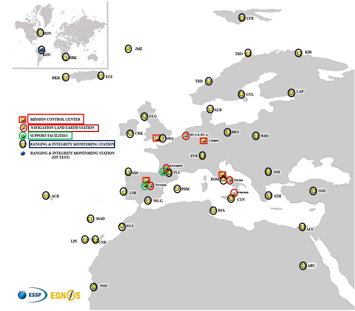
EGNOS infrastructure consists of three geostationary satellites over Europe and a network of ground stations (Ranging and Integrity Monitoring Station – RIMS) located to provide services whose coverage includes southern Europe, North Africa and some Middle East countries.
The EGNOS RIMS network supports a flexible network geometry that gradually adapts to service coverage requirements evolution. From the originally envisaged coverage over European Union’s countries, the EGNOS RIMS network is being expanded over Europe’s neighbouring areas, thus increasing the number of beneficiary countries. EGNOS SoL service is highly sought by several non-EU countries for the benefits it can bring to their civil aviation, in providing a solution to comply with ICAO requirements for Performance Based Navigation (PBN).
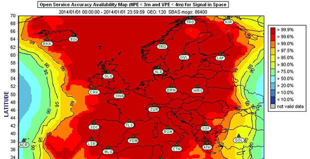
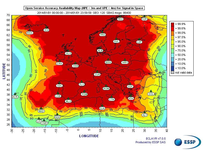
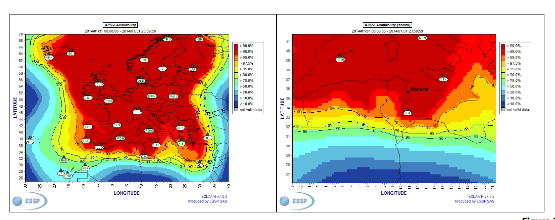
The present layout of the EGNOS RIMS network is presented in Figure 1.
Figure 1. EGNOS ground segment.
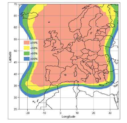
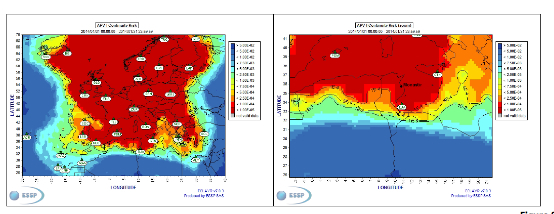
Figures 2 and 3 show respectively today’s coverage of EGNOS OS availability (source: European Satellite Services Provider, the service provider of EGNOS) and the APV-I availability performance commitment provided by EGNOS SoL (source: EGNOS Safety of Life Service Definition Document, EGN-SDD SoL, V2.0, European Commission, 2013), obtained relying on the above presented ground segment.
Figure 2. EGNOS OS Availability.
EGNOS OS Availability. The Figure 2 map is obtained by projecting the error at pseudorange level into the position domain. The computed error assumes that the GPS satellites used are those with an elevation angle above the local horizon (with a mask angle of 5º) and does not consider any possible factor depending on local characteristics that could produce different results (optimistic or pessimistic) with respect to the results computed using real receivers located in the considered areas. Moreover, it represents an estimation of EGNOS OS availability during a very limited period of time being an estimation, thus it does not imply any commitment or reference for the performances which can be obtained during different periods.
Figure 3. EGNOS APV-I Availability.
Other initiatives for a further extension in North Africa and Middle East are already being developed, under the umbrella of the Euromed GNSS programme. In parallel with the infrastructure deployment, the Euromed GNSS programme also includes actions to support the introduction and exploitation of EGNOS services. The first stage was completed in the frame of the Euromed GNSS I/MEdiTerranean Introduction of GNSS Services (METIS) project in the period 2006-2009, the second stage is presently running in the frame of the Euromed GNSS II/MEDUSA project. Further initiatives are being planned for 2015 and beyond.
EGNOS Use in Aviation
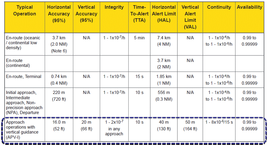
EGNOS was initially designed and developed to be used in aviation, similarly to the U.S. Federal Aviation Administration WAAS, to support different types of aviation applications and, in particular, to meet the performance requirements set by the International Civil Aviation Organization (Annex 10) for the implementation of APV-I, which enable the implementation of LPV final approaches, as reported in Table 1.
Table 1. ICAO Operational Requirements.
EGNOS is one of the GNSS elements recognised by ICAO (Annex 10) as a radionavigation aid. It is an important element of a global SBAS systems mosaic, that started with the American system WAAS in 2003, and that is gradually completed by other more recent SBAS: EGNOS itself, MSAS (Japan), GAGAN (India), SDCM (Russia), and some countries like Australia and South Korea that have launched feasibility studies to develop their own SBAS.
It is expected that, in a not too far future, most parts of the world will profit from SBAS services, following the current coverage extension plans and SBAS system evolutions. The final objective, as also shared at ICAO level, is that as many airdromes worldwide, as possible, can offer instrument approaches with vertical guidance, with an outstanding increase in global safety rates.
Additionally, the use of EGNOS allows taking full advantage of GNSS for all phases of flight, including final approach. Therefore, EGNOS means for aviation a fundamental and strategic tool to help meet ICAO’s recommendations, aimed at the adoption of a PBN oriented airspace use policy, for all countries. The 37th Assembly of ICAO (28 September – 8 October 2010) resolved that APV procedures should be implemented as either a primary or backup strategy for precision approaches at all instrument runway ends by 2016.
APV is a major safety initiative. ICAO recognises SBAS and Barometric Vertical Navigation (Baro-VNAV) as the two acceptable (and often complementary) means of implementing APV procedures, which are safer than NPA (Non Precision Approach).
GNSS based navigation enables RNAV (aRea NAVigation) with a higher cost effectiveness in comparison with the old conventional, sensor ground-based, navigation procedures. This is especially true for wide, even desert unequipped areas (or difficult to maintain) like those in North Africa and Middle East.
EGNOS benefits are maximized in final approach manoeuvres, providing GNSS lateral and vertical guidance, and enabling APV-I approaches.
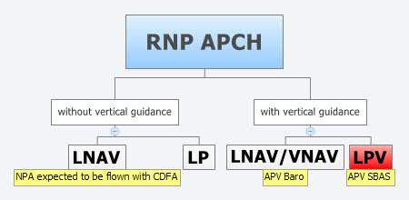
Final approach procedures based on GNSS are classified as RNP approaches (RNP APCH, as shown in the next figure), namely: Lateral Navigation (LNAV) with GPS lateral guidance and no vertical guidance; LP with GPS + SBAS (EGNOS) for lateral guidance (CAT-I localizer performance) and no vertical guidance; Lateral Navigation/Vertical Navigation (LNAV/VNAV) with GPS lateral guidance and Baro-Vertical Navigation (VNAV) vertical guidance (Baro-VNAV approach procedures can be flown with SBAS vertical guidance upon the approval of the Air Navigation Service Provider (ANSP)) and the LPV (Localizer Performance with Vertical Guidance) with GPS + EGNOS for both lateral and vertical guidance.
Figure 4. RNP approaches.
Those procedures not including vertical guidance are intended to be flown with the Constant Descent Final Approach (CDFA) technique (to avoid dangerous dive and drive practices), supported by most Flight Management Systems (FMS).
Regarding the operational LPV main figures, the European regulation (EU OPS -REGULATION (EC) No 859/2008 usually known as EU OPS) allows LPV operational minima (Decision Height – DH) down to 250 ft, expected to be possibly lowered down to 200 ft by 2015 (LPV-200), similarly to what is already permitted by the FAA, in the United Sates for WAAS based LPV approaches (a DH of 200 ft would make LPV approaches very competitive, when benchmarked against ILS CAT-I, precision approach, or even Ground Based Augmentation System (GBAS) CAT-I precision approach).
In the last few years, about 150 LPV procedures (status as of July 2014) have been published in European airports, and the number of procedures and countries introducing EGNOS is continuously increasing.
Euromed GNSS I/METIS and Euromed GNSS II/MEDUSA
In parallel with the development of the infrastructures necessary for extending EGNOS availability across the Euromed region, the European Commission has put in place initiatives to prepare and assist the Euromed countries for the optimal use and adoption of the relevant services.
These consist in two sequential projects, the first being Euromed GNSS I/METIS project and the second being Euromed GNSS II /MEDUSA.
Running from mid 2006 up to the end of 2009, METIS acted as a pioneer in the Euromed countries and built national/regional liaisons with decision-makers and key stakeholders, interested in sharing experience and absorbing know-how. The project assisted the 10 Euromed countries to identify their priorities in relation to the use of EGNOS services, to validate the relevant opportunities from the strategic/social and economic perspectives, and to elaborate a suitable strategy and a plan of actions for facilitating EGNOS adoption and exploitation.
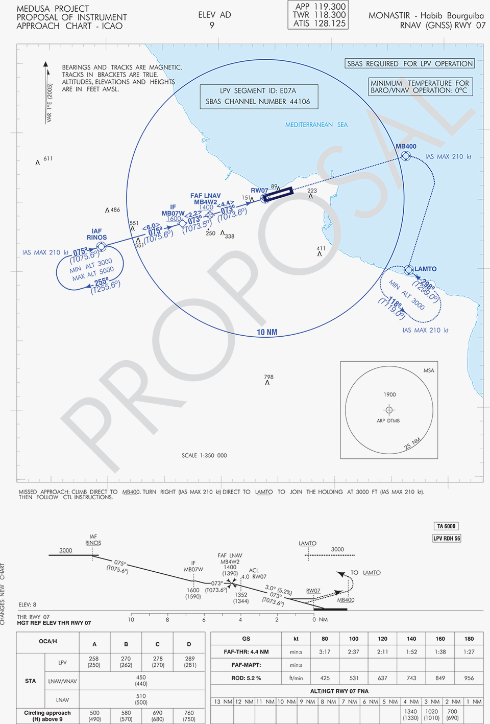
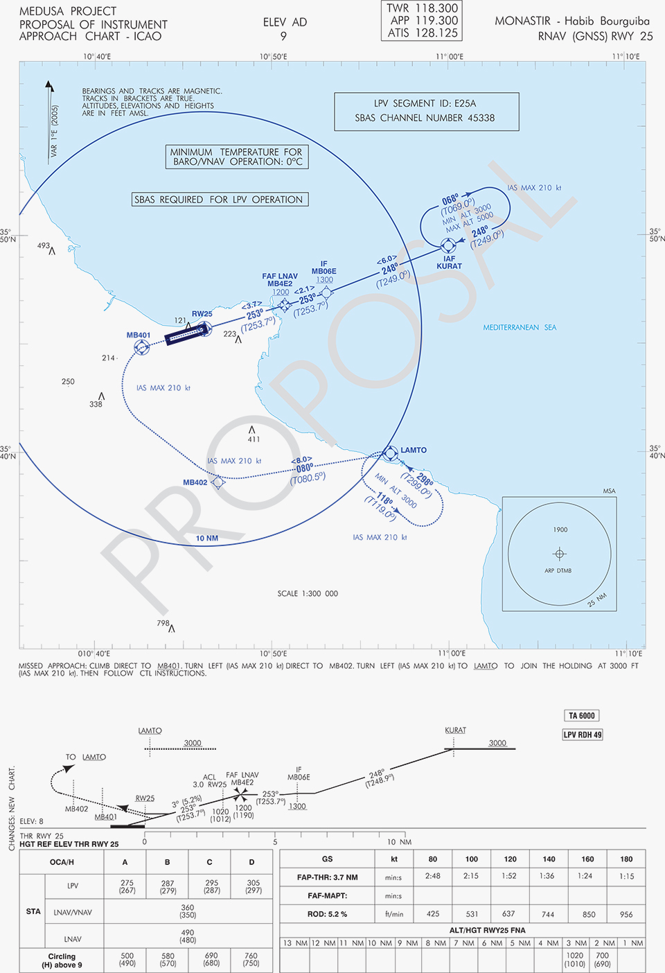
MEDUSA Case Study in Tunisia: LPV Approaches in the Airport of Monastir Using EGNOS
As part of the technical assistance actions programme in the priority domains, MEDUSA implements demonstrations and validations of EGNOS services in concrete applications.
For EGNOS SoL, the technical assistance action consisted in the validation of GNSS approaches, including LPV approaches, designed and constructed in MEDUSA along with the relevant safety assessment and business case for the airport of Monastir in Tunisia (35°45’29’’ N 10°45’17’’ E). The selection of the airport was driven by a trade off between the EGNOS service availability with required APV-I performances and the specific needs of the Tunisian Air Navigation Service Provider – ANSP (OACA, Office de l’Aviation Civile et des Aéroports). According to OACA, Monastir is among the airports in Tunisia presenting favourable conditions, in terms of operational constraints and traffic, for concretely proving the added value of EGNOS for final approaches.
The airport has two runways, RWY 07 and RWY 25, the former is equipped with an ILS CAT-I, the latter only supports NPA approaches. The installation of an ILS in RWY 25 was discarded due to technical constraints. This infrastructure has proven to be insufficient to fully cover the airport needs, that suffers some Delays-Diversions-Cancellations (DDCs) as a result of local specific meteorological conditions, frequent fog banks entering from the sea in the early morning, combined with desert haze. These conditions make LPV ideal procedures, as backups to RWY 07, and enabling APV approaches to RWY 25. Finally, Monastir’s TWR ATC (Tower Air Traffic Control ) staff has been involved in OACA’s PBN development, for which they were ideal candidates to evaluate the benefits possibly achievable from the use of EGNOS.
This MEDUSA’s technical assistance action is the first complete experience for the use of EGNOS SoL service outside Europe. It was conceived as a realistic exercise of RNP APCH procedures implementation, following the guidelines provided by ICAO in the “EUR RNP APCH Guidance Material (EUR Doc 025)” and including all the activities required, from the scenario adequacy study to flight validation and the requirements analysis for the final publication in the AIP (Aeronautical Information Publication). OACA was directly involved in all activities, providing inputs/feedbacks and for training purposes.
A set of three GNSS based approach procedures was produced for each RWY, following ICAO 8168 PANS OPS design principles. The next figures show the combined charts type elaborated, that include minima boxes for three RNP approaches (LNAV, LNAV/VNAV and LPV). The procedures construction preserves the current Monastir arrivals structure, following airspace management principles and facilitating the operational approval. As illustrated in the charts, in both cases for the three minima the calculated OCH (Obstacle Clearance Height) values improve with respect to the already existing conventional approaches, providing significant operational and safety benefits.
Figure 5. GNSS approaches for RWY 07.Figure 6. GNSS approaches for RWY 25.
An on-site GNSS performance monitoring campaign was performed by OACA, with the support of GEMCO’s staff, 3 months before the flight trials schedule, covering both EGNOS and GPS signal performances. Besides, an APV-I availability study for the area and specifically for Monastir airport during 1 month before the flight validation was purposely elaborated by the European EGNOS service provider (ESSP). Both analyses, confirmed suitable APV-I performance in terms of availability and continuity, making feasible the implementation of LPV approach procedures in line with ICAO prescriptions.
The next figures show the EGNOS APV-I availability and continuitymeasured on one day during the period of the flight validation (conducted from 30 January to 1 February 2014), in particular at Monastir airport for the considered time-lag:
APV-I availability was over 99%;
APV-I continuity presented a total value lower than 5×10⁻⁴/15s;
95th percentile of Horizontal APV-I accuracy was between 1.1 and 1.2 meters and the 95th percentile of Vertical APV-I Accuracy is around 1.4 meters, thus showing a very good accuracy level;
Horizontal and Vertical safety indexes were lower than 0.25, representing a very good integrity margin.
Additionally, the results of the on-site GNSS performance monitoring campaign showed quite stable performances with small fluctuations during the whole period of observation, and no problems or outages were observed.
(EGNOS APV-I Availability is defined as the percentage of epochs in a month in which the Protection Level are below Alert Limits for this APV-I service (HPL<40m and VPL<50m) over the total period (source: ESSP).
EGNOS APV-I Continuity Risk is defined as the result of dividing the total number of single continuity breaks using a time-sliding window of 15 seconds by the number of samples with valid and available PA navigation solution. A single continuity break occurs if the system is available at one epoch and becomes not available for the following 15 seconds (source: ESSP).)
Figure 7. APV-I availability on 31.01.2014.Figure 8. APV-I continuity on 31.01.2014.
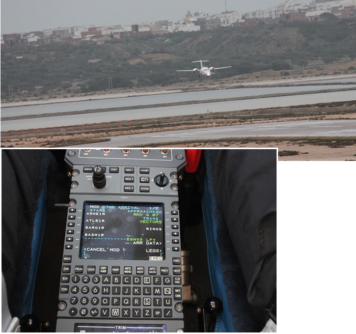
The flight validation campaign was carried out according to ICAO doc 9906 with a Piaggio P180 Avanti II (from ENAV flight inspection department) suitably equipped with UNIFIS 3000 system and a Rockwell Collins FMS 3000 with SBAS LPV approach capabilities.
Figure 9. Piaggio P180 Avanti II aircraft and the FMS messages during the flight validation.
The outcomes of this concrete experience have allowed the Tunisian authorities to identify the main elements for the publication of the validated procedures in their national AIP. They have also contributed to the analysis of the necessary process for the operational adoption of GNSS, including EGNOS, in aviation in countries beyond the EU boundaries.
The activities performed on performance assessment have been preparatory for discussions on GNSS monitoring and data recording on going at ICAO Navigation System Panel level, that would produce ICAO guidelines for States.
Therefore, this Tunisia’s “case study” represents a practical and realistic example that could be beneficial for the other non-EU countries in terms of best practice and lesson learnt. Moreover, methodology and guidelines have been derived to be possibly injected to other non-European countries interested to introduce EGNOS operations in aviation.
Lessons Learned and Outlook
Through its achievements, MEDUSA is opening the way for the introduction of EGNOS SoL service in North Africa and Middle-East region, and it is also defining a suitable path to be followed by other interested non-European countries. Overall, MEDUSA is continuing to confirm the ability to foster cooperation and involvement in EGNOS programme of the great majority of the Euromed countries. Further to Tunisia, other Euromed countries have already expressed their interest in relation to the EGNOS use in aviation, considering each country’s strategy and also in the light of a common shared regional perspective. Besides, the results obtained by MEDUSA are useful also for other regions interested to use EGNOS in aviation.
Additionally, MEDUSA is clearly showing that Euromed region, presently lacking the full support of SBAS technologies, represents an opportunity for EGNOS service extension, with many benefits for the countries of the region and for Europe.
On one hand, being SBAS an effective and efficient technology to enable the aviation community of the Euromed countries to comply with ICAO recommendations on PBN implementation by year 2016 across the region, the services coverage extension of existing SBAS systems (EGNOS in the case of the Euromed countries) can be one of the most efficient ways to move forward. In fact, the Euromed national ANSPs consider the readiness of EGNOS SoL service as one of the main drivers and factors when designing their PBN strategy. EGNOS, which is already operational since 2009 and available for use in aviation since 2011, can deliver added-value services to the Euromed region, just by leveraging the existing European infrastructure with only incremental, marginal and natural extension. The EGNOS coverage extension across the Euromed region can provide significant benefits and particularly to those Euromed countries with few ILS or reduced navaids coverage, and enhance safety and efficiency to the whole aviation community.
On the other hand, the European Union has to gain from an EGNOS-based long term links with its neighbouring regions, by increasing bilateral/multilateral cooperation and interaction (e.g. assistance, mutual cooperation) among public and semi-public bodies (e.g. ANSPs, Civil Aviation Authorities), by strengthening EGNOS SoL coverage in the southern/peripheries of EU (e.g. Malta, Cyprus, Greece, Southernest Italian islands, Canary islands), by pursuing and supporting other EU policies in several sectors (like transports, e.g. harmonizing aviation safety standards across the Mediterranean, Transport Policy of the Mediterranean Partners), and last but not least by achieving a first step towards EGNOS extension to the whole African continent which will bring in similar, additional benefits just described above.
They said it wasn’t possible — well to be frank, I said it wasn’t possible – but one of the two “misplaced” Galileo satellites, plucky Doresa, has delivered an early Christmas present to the European GNSS community by providing a first fix on Tuesday, December 9. The signal was received at the European Space Agency’s (ESA’s) technical centre in Noordwijk, the Netherlands and at the Galileo In-Orbit-Validation (IOV) test station at Redu in Belgium. Doresa teamed with the remaining three functioning Galileo IOV satellites to provide a Galileo positioning data first fix with horizontal accuracy better than two metres.
Since then fixes have also been performed using Galileo’s Public Regulated Service (PRS), the civilian encrypted highest-precision signal and one of the constellation’s unique selling points.
The satellite had transmitted its first navigation signal in space on November 29, following its attainment of a safer, more stable, and more circular orbit with the perigee some 3,500 kilometres higher than its original placement.
Doresa’s salvage has been a slow and steady journey since it was placed, with sister satellite Melina, into a fairly useless orbit in August following a launch anomaly. The original orbit, with a 26,000-kilometer apogee and a 13,800-kilometer perigee, prevented their use for navigation services because they were too low during part of their orbit to sense the horizon and correctly determine their own position. They were also getting a daily dose of radiation from the Van Allen belts.
Elevation
The elevation of the satellite started in late October and involved 11 firings of Doresa’s on-board thrusters. The craft now has only 15 kilos left from its original 65 kilo fuel payload but, given the fact that normally Galileo satellites are not required to make regular orbital manoeuvres, ESA engineers estimate this should be enough for a good 12 years of operation in the new orbit.
The next stage will be to repeat this manoeuvre with the second Full Operational Capability (FOC) satellite, Melina, according to a plan to get that into a similar orbit by the New Year. Pending tests of their positioning, navigation, and timing payloads, the two spacecraft are then likely to be able to contribute to the future Galileo navigation constellation. This was confirmed by Didier Faivre, ESA’s director for navigation, during the agency’s ministerial council meeting on December 2 in Luxembourg.
This end result is the best possible scenario given where the satellites were left after launch and is a considerable triumph for ESA’s mission control teams and flight engineers. Doresa is now able to use its Earth sensor continuously and keep its antennae orientated towards the Earth. Despite more than a month’s exposure to the Van Allen radiation, testing so far has shown no ill effects.
“The very good geometry of the satellites in the sky relative to the receivers helped us to achieve this result, plus the signal strength of the fifth satellite,” explained Gustavo Lopez Risueno, coordinating the receiver team at the Navigation Laboratory in ESA’s ESTEC technical centre.
The satellite signals should be usable immediately, in combination with additional navigation message information provided through ground networks, with mass market receivers. In fact the ESTEC Navigation Laboratory, working in conjunction with the European Commission and the European GNSS Agency (GSA), have already performed position fixes with both Galileo and GPS satellites using only navigation-assistance information.
With some adjustments to the Galileo network’s ground infrastructure, it looks like Doresa and Melina will be able to carry out most of the roles they were originally designed to do. They are the first of 22 Galileo FOC satellites to be built by OHB and launched by ESA over the next few years.
Toasted antennae
More good news. The problem with Galileo’s fourth IOV satellite, named Sif, that took it out of action at the end of May seems to have been characterised and — again — indicates that the satellite is not a complete loss to the constellation. While Sif’s E5 and E6 frequency bands are definitively blown, the satellite’s E1 Open Service band should be capable of broadcast.
The problem appears to have been a defective antennae. The four IOV satellites utilise one antennae design, while the FOC satellites have a different design. Fortunately there is no sign of a similar issue with the three other IOV craft, but they have been operating on reduced power as a precaution while the root cause of Sif’s failure is determined. ESA is currently fail-testing an example of the culprit antennae in the laboratory to see if the failure mode can be characterised.
“One of the possible root causes links the problem with the power emitted by the antenna. When we know more we’ll decide what to do with the other three. Since this event occurred in May and June, no more issues have arisen,” Faivre said.
Agreement
This is all a remarkable turnaround and good news for the wider European GNSS community and those stakeholders who have invested in the Galileo programme and its burgeoning application industry. Let’s hope the good fortune continues through 2015.
The administrative side of things is certainly moving on with the signing in October of an agreement which delegates a range of exploitation tasks for Galileo from the European Commission to the GSA, providing a framework and budget for the development of services and operations through to 2021.The signing of the agreement is an initial step towards the full Galileo Exploitation Phase. Current planning calls for this exploitation phase to be progressively rolled out from 2015, with full operability scheduled for 2020.
“With Galileo, we aim to provide a tangible service to European citizens, and this Delegation Agreement ensures we have the tools and funding necessary to achieve this,” said GSA Executive Director Carlo des Dorides. The agreement was signed by Daniel Calleja Crespo of the European Commission and des Dorides. The document specifically sets the actions to be implemented, the amount of funding provided, and the conditions for the overall management.
Innovation
In the same month, the First Satellite Masters Conference took place in Berlin on October 23 and 24. The conference encompassed the 2014 edition of the European Satellite Navigation Competition (ESNC). The event was a great showcase for the innovation, skill, and passion of the entrepreneurs, usually young, who are building the satellite application market in Europe.
For example, the winner of the GSA special prize at ESNC 2014 is developing Galileo modules for the Google Ara modular smartphone concept, a potential game-changer for positioning in the mobile-phone market. Ara uses interchangeable modules to deliver a smartphone that can be whatever a user wants it to be, complete with first- and third-party components including sensors, cameras, radio antennas, and more. Consumers will be able to order them as of January 2015.
Google developers believe an Ara smartphone will last multiple years, much longer than current hardware, since it won’t be obsolete nearly as quickly. Further, Ara could open the smartphone market to billions of new users across the globe.
I spoke with Giovanni Vecchione of Deimos Space, who received the € 40 000 GSA/ESNC prize during the awards ceremony at Deutsche Telekom’s magnificent headquarters in the German capital.
“With a traditional chip structure, all of a smartphone’s functions are currently combined into a single component, which makes it difficult to add or change a function,” explained Giovanni. “With a modular structure, you have the option to simply switch out a component, meaning a smartphone’s capabilities can be easily enhanced.”
Vecchione’s innovation is to use another of Galileo’s unique selling points: the E5 broadband signal. While mass market smartphones will use the E1 signal, the availability of high-end phones offering enhanced accuracy through the use of the E5 signal will appeal to many users. A second module will implement an external antenna interface. Together these developments could deliver an ARA phone offering high precision (centimetre-level accuracy) positioning and multipath-resistant solutions.
Wishing you all a very peaceful and prosperous New Year and hoping Santa has your coordinates accurately entered in his sleigh satnav!
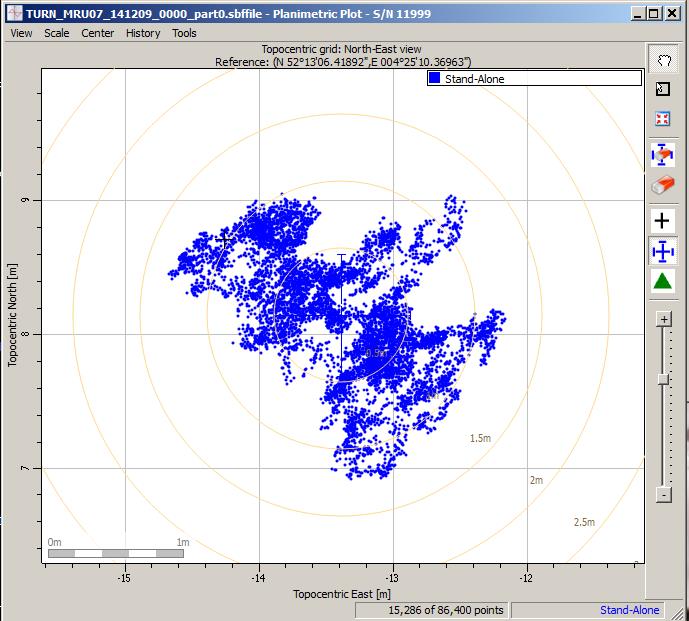
Scatter plot of the Galileo fix performed in ESA’s Navigation Laboratory at its ESTEC technical centre on 9 December 2014. The plot was calculated by the Lab’s Septentrio Test User Receiver, with dispersion of less than 2 m.
News from the European Space Agency
Galileo’s fifth satellite — recently salvaged from the wrong orbit to begin navigation testing — has been combined with three predecessors to provide its first position fix.
Test receivers at ESA’s technical centre in Noordwijk, the Netherlands, and at the Galileo In-Orbit Test station at Redu in Belgium received the signals at 12:48 GMT on December 9 from the quartet of satellites and fixed their horizontal positions to better than 2 meters.
This achievement is particularly significant because the fifth satellite is the first of a new design of 22 Galileo satellites set to be launched over the next few years.
Further position fixes were then made by France’s CNES space agency in Toulouse, France, as noted by Bernard Bonhoure: “The results are as good as those for the first Galileo fixes in 2013 with the initial four satellites.”
The following day, fixes were performed using Galileo’s Public Regulated Service, the encrypted highest-precision class of signal.
“The very good geometry of the satellites in the sky relative to the receivers helped us to achieve this result, plus the signal strength of the fifth satellite,” explained Gustavo Lopez Risueno, coordinating the receiver team at the Navigation Laboratory in ESA’s ESTEC technical centre.
“This is a significant milestone for the Galileo program because it marks the very first time that a Full Operational Capability satellite has performed a fix together with its In-Orbit Validation predecessors — which were the first four satellites launched into orbit, in 2011 and 2012. This establishes they work together well.
“While it is not yet possible to make routine use of the fifth Galileo, this shows such an outcome is within our reach.
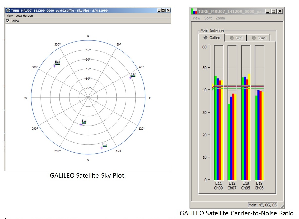
Galileo satellite geometry and received signal strength for the December 9 fix using the first Galileo FOC satellite. The first Galileo FOC satellite corresponds to E19 on the left display; IOV PFM to E11, FM2 to E12 and FM3 to E19.
“In particular, it opens the door to its immediate use in combination with additional navigation message information provided through ground networks, which is a standard mode of operation for mass market receivers, such as those found in our smartphones.”
The fifth and sixth satellites were delivered into the wrong orbit by their Soyuz–Fregat rocket in August. Their elongated orbit took them out to 25,900 km above Earth and back down to 13,713 km, rather than the planned circular path at 23,222 km. The angle of the orbit to the equator was also wrong.
The satellites’ shifting altitude left them unable to lock onto Earth for part of each orbit, preventing them from being used for navigation purposes.
But, last month, a series of 11 maneuvers took the fifth satellite into a more circular orbit, some 3500 km higher, allowing its navigation payload to be switched on for testing. A similar salvage operation is planned soon for its companion.
The main hurdle in using the fifth (and subsequently sixth) satellite operationally is that mass market receivers in particular might take longer to find it. Their orbits fall outside the almanacs satellite-locating standard broadcast within navigation messages.
Utilizing navigation-assistance information would be a way of shortening acquisition times — and ESTEC’s Navigation Laboratory has already demonstrated it with mass market receivers.
Working in conjunction with the European Commission and Europe’s Global Navigation Satellite Systems Agency, the Lab performed position fixes with both Galileo and GPS satellites using only navigation-assistance information.
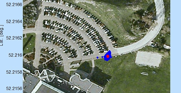
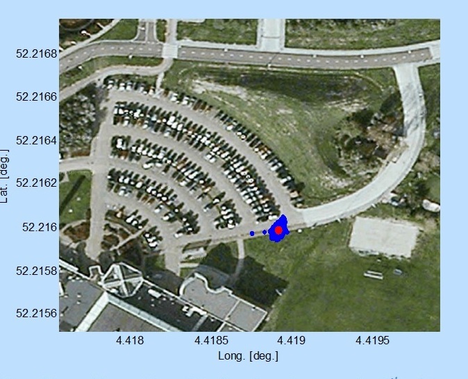
Test position fix in the grounds of ESTEC, performed with a mass-market receiver using navigation-assistance information, based on signals from the fifth Galileo satellite plus GPS satellites. This satellite’s elliptical orbit means extra data are needed to speedily utilize its signals, which could be provided through ground networks. Navigation-assistance information is already employed by the mass market receivers found within smartphones. Source: European Space Agency
EDITOR’S NOTE: Researchers at the German Aerospace Center (DLR) report on their success in producing a pseudorange-based all-Galileo position fix using precisely determined satellite orbits and clocks from Technische Universität München (TUM) in the January issue of GPS World. Richard Langley reports that his team at the University of New Brunswick has managed to produce a Galileo-only carrier-phase-based precise-point-positioning solution with better than decimeter accuracy using TUM’s orbits and clocks.
Also, GMV performed a first Galileo-only PPP with IOV + FOC-1 satellite with data from December 6, obtaining centimetric accuracy. Read about their results on their blog.
On November 25, the European GNSS Agency (GSA) kicked off the contracts for two new EGNOS GEO transponder services provided by SES.
The kick-off was done with the support of the European Space Agency (ESA) and the EGNOS service provider ESSP. Initially awarded and signed by the European Commission, in line with a new delegation agreement between the commission and the GSA, responsibility for the oversight of the contracts has been assigned to ESA.
The contracts regard the provision of signals from two EGNOS transponders embarked on-board the SES-5 and ASTRA-5B geostationary satellites, both operated by Luxembourg-based SES. The ground-based signals are generated via redundant uplink stations located in Betzdorf, Luxembourg and Redu, Belgium.
The signals include the navigation messages computed by the EGNOS Mission Control Centers. Both satellites are capable of transmitting dual-frequency signals compliant with GPS L1/L5 and Galileo E1/E5 signal specifications. The signals will be introduced into the EGNOS service provision (L1-only signals) between 2015 and 2016.
Europe’s fifth Galileo satellite, one of two delivered into a wrong orbit by VS09 Soyuz-Fregat launcher in August, transmitted its first navigation signal in space on Saturday, November 29. It has reached its new target orbit and its navigation payload has been successfully switched on.
A detailed test campaign is under way now the satellite has reached a more suitable orbit for navigation purposes.
Recovery
The fifth and sixth Galileo satellites, launched together on August 22, ended up in an elongated orbit traveling up to 25,900 km above Earth and back down to 13,713 km.
A total of 11 maneuvers were performed across 17 days, gradually nudging the fifth satellite upwards at the lowest point of its orbit. As a result, it has risen more than 3,500 km and its elliptical orbit has become more circular.
“The maneuvers were all normal, with excellent performance both in terms of thrust and direction,” explained Daniel Navarro-Reyes, ESA Galileo mission analyst. “The final orbit is as we targeted and is a tribute to the great professionalism of all the teams involved.”
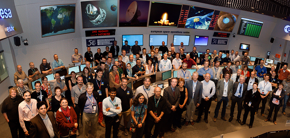
The Launch and Early Operations Phase (LEOP) for Galileo satellites is overseen by a joint operations team from ESA and the French space agency CNES, alternately working from ESOC in Darmstadt, Germany, and the CNES LEOP Control Centre in Toulouse, France. Photo: ESA
The commands were issued from the Galileo Control Centre by spaceopal, the Galileo operator, at Oberpfaffenhofen in Germany, guided by calculations from a combined flight dynamics team of ESA’s Space Operations Centre, ESOC, in Darmstadt, Germany and France’s CNES space agency. The commands were uploaded to the satellite via an extended network of ground stations, made up of Galileo stations and additional sites coordinated by France’s CNES space agency. Satellite manufacturer OHB also provided expertise throughout the recovery, helping to adapt the flight procedures.
Until the maneuvers started, the combined ESA–CNES team maintained the satellites pointing at the Sun using their gyroscopes and solar sensors. This kept the satellites steady in space but their navigation payloads could not be used reliably.
In the new orbit, the satellite’s radiation exposure has also been greatly reduced, ensuring reliable performance for the long term.
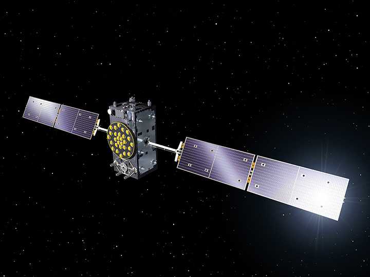
A Galileo Full Operational Capability (FOC) satellite, following on from the first four Galileo satellites already in orbit. A total of 22 FOC satellites are on the way, built by OHB in Germany with navigation payloads from Surrey Satellite Technology Ltd. in the UK. Photo: ESA
A suitable orbit
The revised, more circular orbit means the fifth satellite’s Earth sensor can be used continuously, keeping its main antenna oriented towards Earth and allowing its navigation payload to be switched on.
Significantly, the orbit means that it will now overfly the same location on the ground every 20 days. This compares to a normal Galileo repeat pattern of every 10 days, effectively synchronizing its ground track with the rest of the Galileo constellation.
The navigation test campaign
The satellite’s navigation payload was activated on November 29, to begin the full In-Orbit Test campaign. This is being performed from ESA’s Redu centre in Belgium, where a 20-meter-diameter antenna can study the strength and shape of the navigation signals at high resolution.
“First, the various payload elements, especially the Passive Hydrogen Maser atomic clock, were warmed up, then the payload’s first ‘signal in space’ was transmitted,” said David Sanchez-Cabezudo, managing the test campaign.
“The satellite-broadcast L-band navigation signal is monitored using the large antenna at Redu, with experts from OHB and Surrey Satellite Technology Ltd — the payload manufacturer, based in Guildford, UK — also on hand to analyze how it performs over time.”
The first Galileo FOC navigation signal-in-space transmitting in the three Galileo frequency bands (E5/E6/L1) was tracked by Galileo Test User Receivers deployed at various locations in Europe, namely at Redu (B), ESTEC (NL), Weilheim (D) and Rome (I). The quality of the signal is good and in line with expectations.
The Search And Rescue (SAR) payload will be switched on in few days in order to complement the in-orbit test campaign.
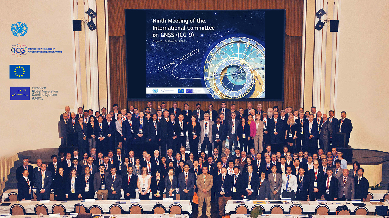
The European GNSS Agency (GSA) hosted the ninth meeting of the International Committee on Global Navigation Satellite Systems (ICG) in November at its headquarters in Prague, Czech Republic. The event is an opportunity for GNSS providers to present the status and future plans for their systems, and an opportunity for ICG members, associate members, and observers to provide updates on recent developments with regard to GNSS services and applications.
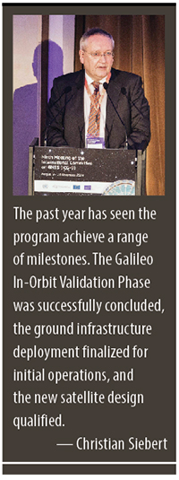
Representatives from the world’s leading global and regional GNSS programs were invited to provide the assembly with a “state of play” for their respective systems. Joining GPS, GLONASS, BeiDou, IRNSS/GAGAN, and QZSS was Galileo, represented by Christian Siebert, Head of Unit, Galileo and EGNOS: Applications, Security and International Cooperation, DG Enterprise and Industry, European Commission.
A Secure Foundation
The key message coming from Prague was that, despite the launch anomaly in August, the Galileo program has a secure foundation for moving forward. For instance, it has been given a stable seven-year perspective, a substantial budget, and a new exploitation-driven governance scheme. In terms of budget, the European Commission has allocated €1.930 billion for deployment and €3 billion for exploitation — with an additional €1.580 billion allocation for European Geostationary Navigation Overlay Service (EGNOS) exploitation.
The new governance scheme is based on a recently announced agreement between the European Commission and the GSA; the agreement delegates a range of exploitation tasks for Galileo to the GSA. Serving as an initial step towards the full Galileo Exploitation Phase, the GSA’s responsibilities now include:
provision and marketing of the services;
management, maintenance, continuous improvement, evolution and protection of the space and ground infrastructure;
research and development of receiver platforms with innovative features in different application domains;
development of future generations of the system;
cooperation with other GNSS;
all other required activities to ensure the development and smooth running of the system.
This new budget and governance structure ensures the Galileo program’s stability for the next seven years, according to a GSA press release. The agency will progressively manage exploitation activities as delegated by the European Commission, which serves as the program’s supervisor.
At the same time, the European Space Agency (ESA) will continue its role for system design and development.
A Range of Successes
“The past year has seen the program achieve a range of milestones,” said Siebert. “The Galileo In-Orbit Validation Phase was successfully concluded, the ground infrastructure deployment finalized for initial operations, and the new satellite design qualified.”
Even with the satellite launch anomaly that left two satellites in the wrong orbit, the ESA just announced that one of these satellites will soon make a series of maneuvers as a prelude to its health being confirmed. The aim is to raise the lowest point of its orbit — its perigee — to reduce the radiation exposure from the Van Allen radiation belts surrounding Earth, as well as put it into a more useful orbit for navigation purposes. If the operation is successful, the second satellite will follow suit.
As to the cause of the anomaly itself, Siebert said Arianespace has established an inquiry board to investigate, and the European Commission and ESA continue to analyze the best options for recovering the initial mission to the best possible extent. A new launch sequence will be confirmed in the near future.
That being said, the deployment plan for the Galileo constellation is secured, with 26 satellites ordered (four IOV and 22 FOC) and launcher service contracts for the full constellation signed with Arianespace. As to the new satellite design, production proceeds at a good pace, with full operational capability (FOC) satellites being built by OHB Systems and navigation payloads provided by Surrey Satellite Technology Ltd.
In terms of services, the Search and Rescue Forward Link Alert Service successfully tested the networked ground segment last April, and positioning accuracy exceeds expectations.
As to the Commercial Services Demonstrator, the main objective of the demonstrator was to test and characterize the high accuracy and authentication performance obtainable with the Galileo Commercial Service. The first results are extremely promising, with high accuracy already demonstrated through PPP information transmitted via E6B and used to enhance both Galileo and GPS.
Siebert noted that the ongoing Receiver Test Campaign supports manufacturers to ensure that Galileo is well implemented in chipsets and receivers. To accomplish this, the program continues to develop dialogs with the user/receiver segment to understand the market situation and follow up adoption of Galileo.
Looking Ahead
With this secure foundation, looking towards 2015 and beyond, Galileo is set to deliver a reliable, high-quality service to the world, according to EC and ESA spokespersons presenting at the ICG. “With its substantial budget and exploitation-focused governance scheme, it will continue to evolve and introduce innovative features,” Siebert affirmed.
Next steps for the program include a gradual introduction of the early phase of service delivery, which will rely heavily on interaction with users. Early services will be run with continued infrastructure deployments. The program will soon conduct a service validation campaign, along with finalizing the Commercial Service definition and developing a long-term service plan.
“This service plan will be aligned with the trend of most user communities moving towards service levels based on a multi-constellation approach,” concluded Siebert. “Knowing this, it is crucial to continue to improve signal compatibility and interoperability of the Galileo service with other providers and cooperate on building multi-constellation programs.”
Flight Operations Director Hervé Côme celebrating success finding the satellites. Photo: Galileo Control Centre
On September 27, the first two Galileo Full Operational Capability (FOC) satellites were handed over from the European Space Agency’s Space Operations Centre (ESOC) in Darmstadt, Germany, to the Galileo Control Centre, Oberpfaffenhofen, which will care for them pending a final decision on their use.
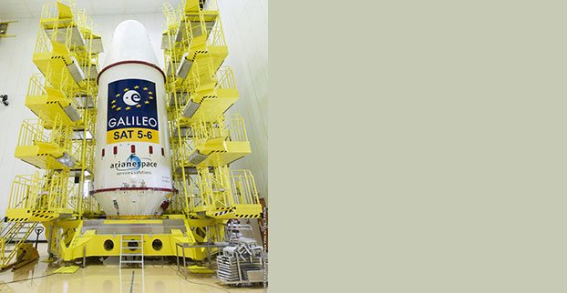
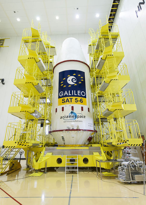
The satellites, launched on August 22, are in excellent health and working normally. However, a launcher problem left the pair in the wrong orbit, with higher apogee, lower perigee and an incorrect inclination compared to the planned circular orbit.
According to a release by the European Space Agency, the orbit presented a sudden and unexpected — though not untrained for — challenge to the team at ESOC responsible for the launch and early orbit phase. For months before each Galileo launch, a joint team of mission operations experts from ESA and France’s CNES space agency train intensively for this critical period, which typically lasts about eight days, from separation until handover to Oberpfaffenhofen.
“After launch, we quickly discovered that one of each satellite’s pair of solar wings had not deployed correctly,” said Liviu Stefanov, Spacecraft Operations manager. “At the same time, difficulties in receiving radio signals — indicated by unusually low power and instability — alerted us to the fact that the orbits could be incorrect. Basically, the ground stations were pointing to where we expected the satellites to be, and they weren’t there, so we weren’t getting good signals.”
The joint ESA–CNES Galileo operations team in the Main Control Room at ESA’s Space Operations Center, August 28. (Photo credit: R. Solaz).
Engineers determined within four hours the approximate actual orbit and then generated new commands to point the ground antennas to establish robust radio links. Working around the clock, and with assistance from the Galileo project engineers and the satellite builder, the teams then started to look at how to free the solar arrays. “Each undeployed wing had to be treated as a separate problem,” said Flight Operations Director Hervé Côme.
“Each satellite had to be maneuvered separately into an orientation where the undeployed panel was facing the Sun because we realized that one cause was linked to the low temperature of the release mechanism. It all required developing, validating and rehearsing new flight operation procedures on the fly.”
It took three days to release the trapped solar wing of the first satellite, and then two days later the second Galileo’s stuck array was also freed. The satellites have since been brought into full operation, as the teams in Darmstadt were tasked to retain control for five weeks — four weeks longer than planned.
“This was very demanding on the ESA and CNES personnel, and on the ESOC operations team in particular, but the strong bonds developed through months of joint training enabled them to perform very well,” Liviu said.
Possible uses of the two satellites are now being studied, and a future mission scenario will be decided at a later date.
While the process of handing over the satellites to the Galileo Control Centre (where they are operated by teams from a private company, spaceopal GmbH), had been practiced in the past, this was the first time it was done with FOC satellites in orbit. The delicate process involves transferring responsibility for commands and telemetry, and beginning the satellites’ secure mode of operation by the teams at Oberpfaffenhofen. The handover ran very smoothly over the last weekend in September.
“By the end of the Saturday, the first satellite was fully handed over, while the second handover took place on Sunday,” said Richard Lumb, ESA’s Galileo Mission director.
“I am extremely proud of the entire Mission Control Team and the way they handled a dramatic and very critical situation resulting from multiple, independent anomalies,” said Paolo Ferri, ESA’s head of Mission Operations. “After launch, the joint team managed to maintain control of the satellites under extremely difficult conditions, rapidly stabilized them, and determined the actual orbit. The accuracy and professionalism of the subsequent handover activities also showed that the joint team at ESOC and the spaceopal team at the Galileo Control Centre are very well tuned for this procedure, which will become increasingly frequent with future launches.”
The European GNSS Agency (GSA) and the European Commission have concluded an agreement that delegates a range of exploitation tasks for Galileo to the GSA, providing a framework and budget for the development of services and operations through 2021.
The signing of the Galileo Exploitation Delegation Agreement serves as an initial step towards the full Galileo Exploitation Phase.
According to the governance structure set out in the Agreement for the Galileo programme, the European Commission is responsible for the overall programme supervision, the European Space Agency (ESA) is entrusted with the deployment phase, while the GSA is responsible for the exploitation phase.
As to the exploitation phase, the GSA’s responsibilities include:
Provision and marketing of the services
Management, maintenance, continuous improvement, evolution and protection of the space and ground infrastructure
Research and development of receiver platforms with innovative features in different application domains
Development of future generations of the system
Cooperation with other GNSS
All other required activities to ensure the development and smooth running of the system
“With Galileo, we aim to provide a tangible service to European citizens, and this Delegation Agreement ensures we have the tools and funding necessary to achieve this,” said GSA Executive Director Carlo des Dorides.
The Galileo exploitation phase will be progressively rolled out starting in 2014-2015, with full operability scheduled for 2020.
The agreement was signed between Daniel Calleja Crespo, director-general of the Enterprise and Industry Directorate-General at the European Commission and Carlo des Dorides, executive director of the GSA. The agreement specifically sets the actions to be implemented, the amount of funding provided, and the conditions for the overall management.
The implementation period of the agreement runs until 2021, with a comprehensive review of its functioning by the end of 2016. The maximum current EU contribution amounts to EUR 490 million, which will cover procurement and grant activities, including the GSA-ESA working arrangements and a programme management reserve, along with related research and development activities. The financing of the full exploitation phase will be confirmed during a mid-term review before the end of 2016.
“Following the failure on Friday August 22nd to inject Galileo satellites 5 and 6 into the correct orbit, the European Commission has requested Arianespace and the European Space Agency (ESA) to provide full details of the incident, together with a schedule and an action plan to rectify the problem.”
This is the only official face showing, but extremely high levels of activity take place behind the curtain, studying what might have caused several million Euros of hardware to end up much lower above the Earth than desired. Meanwhile, active speculation in the satnav blogosphere provides glimpses of possible outcomes from the latest satellite disaster — not exclusive to Galileo, by any means — created in all likelihood by a malfunction aboard its Soyuz launcher and/or the Fregat upper stage thereof.
The full official EC announcement is available here.
The satellites are under the control of the European Space Operations Centre (ESOC), ESA’s main mission control center in Darmstadt, Germany. But they are far out off position — more than 3,500 kilometers of space away, so far as to make their eventual use as part of the Galileo constellation very unlikely. Discussions continue with ESA and Arianespace regarding whether or not the satellites are likely to be of use, but odds are against it.
Their onboard fuel is not enough to compensate for the launch shortfall to reach higher orbits under their own power. ESA scientists are studying how they might still possibly be used, far from their optimum position,s within the Galileo constellation.
According to an Arianespace press release on August 23, the target orbit was circular, inclined at 55 degrees with a semi-major axis of 29,900 kilometers, but what they got was an elliptical orbit, eccentricity of 0.23, semi-major axis of 26,200 kilometers and inclined at 49.8 degrees.
On August 28, the Russian newspaper Izvestia reported that “The failure of the European Union’s Galileo satellites to reach their intended orbital position was likely caused by software errors in the Fregat-MT rocket’s upper-stage.”
“The nonstandard operation of the integrated management system was likely caused by an error in the embedded software. As a result, the upper stage received an incorrect flight assignment, and, operating in full accordance with the embedded software, it has delivered the units to the wrong destination,” an unnamed source from Russian space Agency Roscosmos was quoted as saying by the newspaper.
An independent inquiry panel has been set up by Ariane. It is headed by former ESA Inspector General Peter Dubock. It starts work on August 28. The panel includes a couple of academics and a majority of ESA and EC figures.
Ferdinando Nelli Feroci, the new EC Commissioner for Industry and Entrepreneurship.
The new EC commissioner in this area, Ferdinando Nelli Feroci has invited ESA and Arianespace to his study during the first week of September to present the initial results of the inquiry.
The commissioner commented, “The problem with the launch of the two Galileo satellites is very unfortunate. The European Commission will participate in an inquiry with ESA to understand the causes of the incident and to verify the extent to which the two satellites could be used for the Galileo programme. I remain convinced of the strategic importance of Galileo and I am confident that the deployment of the constellation of satellites will continue as planned.”
The commissioner expects that the Galileo constellation will be fully deployed by the end of this decade. This may qualify as optimism because system planners had envisioned for six spares – and three are already blown.
Ariane and ESA did not insure the satellites.
According to back-of-the-envelope calculations, system operators are now one short of the minimum 24 needed for full 24/7 global coverage, as they have 4 IOVs up (1 broken) and 22 FOCs on order (2 launched and now in what could be called a junk orbit) which makes a potential maximum 23 sats that have actually been ordered – one short of the target.
The Satellites Are Alright
Satellite manufacturer OHB Systems of Bremen, Germany, issued a release stating that “Controllers at ESA’s ESOC control centre in Darmstadt, Germany, confirm the good health and the nominal behaviour of both satellites. They are in a safe configuration, are thermally stable, have stable pointing to the sun and sufficient power production. All platform subsystems have been checked and they work properly. Also the procedures to deploy the solar arrays are successfully performed and all solar arrays are properly unfolded.”
Further, “The orbit anomaly has no impact on the production and delivery of the in total further 20 satellites. Two FOC*-satellites are currently at ESTEC test facilities in Noordwijk, the remaining are in various status of integration. ”
Blogging the Boondoggle
The chairman of the Executive Board of the German Aerospace Center, Johann-Dietrich ‘Jan’ Wörner, writes an interesting blog. The current installment opens with a quote from Elon Musk: “Rockets are tricky.”
Wörner goes on to say, “The Soyuz launcher lifted off from the European Spaceport in French Guiana. Initially, all of the measurements suggested a perfect mission; the launcher took off at the scheduled time, followed the prescribed trajectory, and the stage separation was carried out correctly. However, the first problem became apparent when the two satellites proved unable to deploy their solar arrays as intended. A more detailed analysis then revealed that the eccentricity, the altitude and the inclination of the satellites’ orbits with respect to Earth’s equator did not meet the specifications. The upper stage had also evidently failed to induce the planned rotation around the longitudinal axis of the spacecraft (known as ‘barbeque’ mode, designed to maintain favourable thermal conditions during exposure to the Sun).”
Further discussion of the possible causes of the anomaly can be found on a Russian site, which focuses on the Fregat stage thrusters and indicates that the Russians think the barbeque maneuver was completed, and thus not the problem.
The other big issue is how the telemetry didn’t pick up the issue straight away.
There is avid speculation and a number of interesting theories being aired on the Canadian Space Geodesy Forum. For subscriptions to this vital listserv, visit here.