Tag: European Space Agency

  • Ariane 6 — Galileo’s next ride — undergoes hot-fire tests

    Ariane 6 — Galileo’s next ride — undergoes hot-fire tests

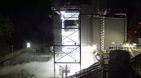
    The Ariane 6 launch vehicle program has taken a dramatic step towards first flight with the start on Oct. 5 of hot-fire tests of the rocket’s upper stage and its all-new Vinci engine, according to the European Space Agency (ESA).

    The tests are a significant step forward. They are being conducted using the specially built P5.2 test bench for engine and stage testing at the German Aerospace Center (DLR) in Lampoldshausen. The P5.2 test bench subjects the entire upper stage to operating conditions representative of a flight from Europe’s Spaceport in French Guiana, with the exception of vacuum and microgravity.

    New Vinci Engine

    Vinci, the upper stage engine of Ariane 6 fed by liquid hydrogen and oxygen, can be stopped and restarted multiple times — a critical capability for the complex missions demanded by launch customers today.

    The rocket can place several satellites into different orbits and de-orbit the upper stage, leaving a minimum of hazardous debris in space. Vinci also has been developed for reliability, simplicity and lower costs.

    Replacement Heavy Launcher

    This test series is a critical milestone on a development path that will soon see Ariane 6 replace Ariane 5 as ESA’s heavy launcher.

    For more than a quarter century, Ariane 5 has been a reliable partner for commercial, institutional and scientific clients. One of its most notable missions was the Dec. 25, 2021, flight that carried the NASA/ESA/CSA James Webb Space Telescope to its operational outpost in deep space.

    But Ariane 6 will be an even more versatile vehicle, strengthening Europe’s autonomy in accessing space.

    Auxiliary Power Unit

    The tests being run at Lampoldshausen are also evaluating an innovative auxiliary power unit (APU) that works in tandem with the Vinci engine and is instrumental to Ariane 6 upper-stage performance.

    To restart in space, earlier engines relied on large quantities of tanked helium to generate the necessary pressure and temperature in the propellant tanks and to ensure there are no bubbles in the fuel lines. However, the APU delivers these conditions using only small amounts of the cryogenic hydrogen and oxygen already carried in the main tanks.

    Heading to ESTEC

    The test series is being run by DLR and ArianeGroup, the Ariane 6 launcher prime contractor. When the test series is complete, the upper stage — integrated by ArianeGroup at its facility in Bremen, Germany — will be shipped to ESA’s ESTEC technical center in the Netherlands for stage separation and acoustic tests.

    Ultimately, the Lampoldshausen tests will investigate hardware behavior and system function of the complete stage with its tanks, engines and avionics.

    “The preparation for these hot firing tests is even more complex than for an actual launch,” said Ariane 6 launcher program manager Guy Pilchen. “Our colleagues in Lampoldshausen have decades of experience in rocket propulsion with extremely advanced test facilities. With ArianeGroup colleagues to control the upper stage and DLR people operating the test bench, we couldn’t ask for a better team.”

    Space independence for Europe

    ESA Director of Space Transportation Daniel Neuenschwander said that this new engine and the upper stage it powers are indispensable components of Ariane 6 and its objective — to guarantee that Europe maintains independent, competitive and sustainable access to space.

    “It’s a fact in the 21st century that Europeans depend on space for safety, prosperity and security,” Neuenschwander said. “Europe needs to work toward complete autonomy in accessing and operating in space. Ariane 6 is key to this, and we are eager to see the liftoff from Europe’s Spaceport in French Guiana.”

    Ariane 6 Vinci engine testing at DLR Lampoldshausen. (Photo: ESA)
    Ariane 6 Vinci engine testing at DLR Lampoldshausen. (Photo: ESA)
  • ESA seeks companies to help guide Moon missions

    ESA seeks companies to help guide Moon missions

    The European Space Agency (ESA) is looking for companies interested in helping create a constellation of lunar satellites to connect and guide missions to the Moon. Creating lasting telecommunications and navigation links with the Moon will enable sustainable space exploration for the hundreds of lunar missions that are due to launch within the next few decades, ESA stated.

    The companies would provide telecommunications and navigation services to these lunar missions, under its Moonlight initiative.

    ESA is completing two studies with two consortia of space companies based in Europe that assess the business case and the technical solutions for building and operating a constellation of lunar satellites. ESA is asking any space firms to indicate whether they would like to become involved in the ambitious project — or simply to develop lunar telecommunication and navigation technologies and products. The deadline is Oct. 28.

    Artist’s rendering: NASA
    Artist’s rendering: NASA

    On Sept. 19, ESA Director General Josef Aschbacher and NASA Administrator Bill Nelson signed a joint statement on lunar exploration cooperation at the International Astronautical Congress in Paris.

    The lunar Gateway  will be an outpost in orbit around the Moon. It will serve as the staging point for both robotic and crewed exploration of the lunar south pole.

    ESA’s European Service Modules will power all Artemis Orion spacecraft to the Moon and back. ESA will also provide refueling elements for Gateway and a communications module that will pave the way for Moonlight.

    ESA has already initiated the Lunar Pathfinder project to provide initial communications services to early lunar missions, which will also help to prepare for the next stage with Moonlight. The Lunar Pathfinder will also include a navigation payload demonstrator, which will allow positioning in lunar orbit using GPS and Galileo systems for the first time, and is due to launch in 2025.

    Space companies in Europe and Canada will be invited to tender for the initial Moonlight work in December.

  • Celestia UK wins ESA contract to improve GNSS signals

    Celestia UK wins ESA contract to improve GNSS signals

    Celestia UK has won a €800,000 European Space Agency (ESA) contract to develop an innovative positioning, navigation and timing(PNT) solution based on LEO satellite constellations for 5G networks and applications.

    The contract was granted under ESA’s Navigation, Innovation and Support Programme (NAVISP).

    Malachy Devlin, CEO, Celestia UK
    Malachy Devlin, CEO, Celestia UK

    Celestia’s LEO-SYN+ project is intended to boost the reliability and performance of GNSS. It will use low-Earth-orbit (LEO) satellite signals of opportunity to provide a resilient position and time reference for 5G networks and improve the robustness of GNSS signals.

    It includes development of a PNT receiver compatible with multi-GNSS constellations and LEO signals of opportunity, as well as testing of the solution in 5G networks. A prototype receiver will validate the product design and the technology development, paving the way for additional applications of the technology to other critical infrastructures after the initial ESA NAVSIP roll-out.

    To deliver the ambitious project, Celestia UK is partnering with Heriot-Watt University, which brings extensive knowledge in satellite communications and digital signal processing, and The Scotland 5G Centre, the national center for accelerating deployment and adoption of 5G and realizing its economic and societal potential for Scotland.

    “It is a great benefit for the business to have won an ESA NAVSIP contract,” said Malachy Devlin, CEO of Celestia UK. “We are looking forward to collaborating with ESA and our partners to unlock the potential to improve the resilience of 5G networks with our PNT solution.”

    Ian Sharp, head of Business Development, The Scotland 5G Centre, added,“The Scotland 5G Centre is providing businesses access to 5G services through a national network of innovation hubs, under its 5GConnect Programme. It is well known that 5G will support higher data throughput and interactive services through reduced latency. However, 5G will also provide new possibilities for positioning, navigation and timing (PNT).  Use of advanced antennas and positioning over satellite will be critical for outdoor applications where precise navigation is essential to meet safety requirements for the likes of drone navigation and autonomous vehicles.  We are delighted to be working alongside Celestia UK, supporting the innovative LEO-SYN+ project, which will utilise our cutting edge 5G network.”

  • Latest Galileo satellites join constellation with enhanced, faster fix

    Latest Galileo satellites join constellation with enhanced, faster fix

    Galileo launch 11 from Europe’s spaceport in French Guyana. (Photo: ESA/CNES/Arianespace)
    Galileo launch 11 from Europe’s spaceport in French Guyana sent satellites 27 and 28 into orbit. (Photo: ESA/CNES/Arianespace)

    News from the European Space Agency (ESA)

    Europe’s latest Galileo satellites in space have joined the operational constellation, transmitting navigation signals to three billion users across Earth as well as relaying distress calls to rescuers.

    Their entry into service follows a summer test campaign and will result in a measurable increase in positioning accuracy and improved data delivery performance of the overall Galileo system.

    Galileo satellites 27-28 were launched at the end of 2021 and underwent in-orbit test review at the end of April. The review was conducted by ESA, satellite manufacturer OHB, and navigation payload maker Surrey Satellite Technology Ltd (SSTL).

    Key findings showed both satellites’ payloads are performing extremely well — among the best in the entire constellation — and the satellites entering into service increase the position accuracy and robustness of the overall Galileo system.

    A successful system and in-orbit operations review followed, co-chaired by ESA and the EU Agency for the Space Programme (EUSPA), which is in overall charge of commissioning.

    Improved navigation message

    The two satellites are the first to broadcast an improved navigation message, resulting in three key improvements for Galileo’s public Open Service users:

    • faster navigation data acquisition, allowing users to establish a first position fix more rapidly
    • better robustness in challenging environments, such as urban centers
    • easier access to timing information in the navigation message for users possessing only a rough estimate of timing of the order of 1-2 seconds.

    For the testing and broadcasting of this new navigation message, new software for the Navigation Signal Generation Unit was developed by Thales Alenia Space in Italy, SSTL, OHB and ESA, and was uploaded to the two satellites.

    During the summer, an extensive test campaign was conducted by ESA to ensure the compatibility of the entire Galileo system at unit, payload, satellite, ground and system levels with the enhanced message. As part of this effort, EUSPA oversaw receiver testing to ensure this compatibility extended to Galileo receivers and chipsets in the market.

    These latest launched satellites made ideal test cases for the software and the improved navigation message. Transmission of the upgraded signals from Galileo satellites 27-28 allowed the team to confirm its correct implementation and characterize its long-term performance.

    Following a successful Test Review Board, the satellites were brought back into service on Aug. 29

  • Seen & Heard: Tracking tar balls, testing SBAS for UK

    Seen & Heard: Tracking tar balls, testing SBAS for UK

    “Seen & Heard” is a monthly feature of GPS World magazine, traveling the world to capture interesting and unusual news stories involving the GNSS/PNT industry.


    Photo: spxChrome/E+/Getty Images
    Photo: spxChrome/E+/Getty Images

    Citizens Clean Up Coasts

    Two citizen groups are taking action with the help of Esri ArcGIS mapping tools. North Coast World Earth uses Esri Ireland’s platform on the Northern Irish coast to record litter hotspots and engage with local communities. The volunteer group has collected nearly 3 tons of litter. In California, the Surfrider Foundation employed ArcGIS Hub to streamline cleanup operations after a major oil spill off Huntington Beach in October 2021. Citizens submitted more than 1,100 reports using the ArcGIS QuickCapture photo app to share the date, time and coordinates of toxic tar balls on beaches from Oxnard to San Diego.


    Photo: ©Goonhilly
    Photo: ©Goonhilly

    UKSBAS Put to the Test

    A new series of tests will assess whether the United Kingdom satellite-based augmentation system (UKSBAS) for GNSS can develop into full operational capability to support safety-critical applications post-Brexit. Inmarsat, Goonhilly Earth Station and GMV NSL are conducting the UK Space Agency-funded tests. The signal is now stable and operational, enabling ongoing testing and validation by industry, regulators and users. If successful, UKSBAS will enable assessment of more precise, resilient and high-integrity navigation for maritime and aviation users in UK waters and airspace.


    Image: ESA
    Image: ESA

    Smart GNSS Monitoring

    More than 11,000 people around Europe and the world have turned their smartphones into GNSS monitoring tools by downloading the CAMALIOT app, so far delivering more than 53 billion measurements of meteorology and space weather patterns to researchers, reports the European Space Agency (ESA). ESA asks CAMALIOT volunteers to leave their smartphones by a window each night with GNSS on. The phones record small variations in satellite signals, gathering data for machine-learning analysis. More than 50 smartphone models with dual-frequency receivers can use the app.


    Image: guirong hao/iStock/Getty Images Plus/Getty Images
    Image: guirong hao/iStock/Getty Images Plus/Getty Images

    Home Grown vs. Imported

    Indian Prime Minister Narendra Modi gave his stamp of approval to his country’s indigenous NavIC during a drone festival May 27. Despite that, the Indian Army purchased three GNSS receivers from Baidu, a Chinese company, instead of relying on home-grown companies as the contract required, reports The New Indian Express. The receivers are for survey stations of the College of Military Engineering. A few Indian manufacturers objected to the purchase, the newspaper said, but their concerns were brushed aside by the Department of Military Affairs.

  • Space Tech Expo Europe opens call for speakers

    Space Tech Expo Europe opens call for speakers

    Space Tech Expo Europe logo

    Space Tech Expo Europe has opened its call for speakers for the free-to-attend conference to be held Nov. 15-17 in Bremen, Germany.

    The conference will focus on the latest advancements in the European and global space industry, including space exploration, in-space manufacturing, launch, system development,  market trends and more.

    The conference will take place alongside the leading supplier trade show with hundreds of exhibitors showcasing the latest space technological advancements. The conference provides attendees with the knowledge on the latest developments in European space. Previous speaking companies include: OHB, NASA, ArianeGroup, Airbus Defence and Space, UK Space Agency, ESA and many more.

    Proposals for speakers will be accepted through April 11, 2022. To submit a proposal or learn more about the event, please visit the Space Tech Expo Europe website.

  • Galileo satellites undergo magnetic testing at ESTEC

    Galileo satellites undergo magnetic testing at ESTEC

    News from the European Space Agency (ESA)

    Within ESA’s Maxwell EMC Facility, each Galileo satellite is switched on as if it were already operating in space. The test procedure is a check of the satellite’s electromagnetic compatibility; all its systems are run together to detect any harmful interference between them.

    Once Maxwell’s main door is sealed, its metal walls form a Faraday Cage, screening out external electromagnetic signals. The anechoic foam pyramids covering its interior absorb internal signals – as well as sound – to prevent any reflection, mimicking the infinite void of space for satellite testing.

    In the photo here, sheathed in multi-layer insulation, the 2.5 x 1.2 x 1.1-meter satellite’s main 1.4-m diameter antenna transmits L-band navigation signals. To its left is the hexagonal search and rescue antenna that will pick up distress signals and relay them to local emergency services, contributing to saving more than 2,000 lives annually.

    A Galileo satellite is tested in the Maxwell EMC Facility before heading for space. (Photo: ESA)
    The Face of Galileo: A Galileo satellite is tested in the Maxwell EMC Facility before heading for space. (Photo: ESA)

    To the bottom right of the navigation antenna are a pair of infrared Earth sensors to keep the navigation permanently locked onto Earth by homing in on the contrast between the heat of Earth’s atmosphere and the cold of deep space.

    Above them is the laser retro-reflector: lasers are shone up to this from International Laser Ranging Service stations to perform an independent check of the satellite’s orbital position down to an accuracy of less than a centimeter, as a backup of standard radio ranging.

    Above that is the circular C-band antenna, which every 45 minutes or so receives the navigation messages from the Galileo ground segment. These signals incorporate corrections for slight clock errors, orbital drift or satellite malfunctions that user receivers can process as they perform positioning fixes, helping ensure Galileo delivers meter-scale positioning to users around the globe.

    What resembles a white baton on the end of the satellite is its S-band antenna, employed to return “housekeeping” telemetry data to mission control on Earth and pick up telecommands to operate the satellite platform and payload – as well as performing the ranging used to estimate the satellite’s position in space.

    The Maxwell EMC Facility is part of the ESTEC Test Centre in ESA’s technical heart in Noordwijk, the Netherlands – Europe’s largest satellite testing facility, which has flight-tested all but two of the 28 Galileo satellites already in orbit, and is doing the same for the next 10 satellites planned to join the constellation.

  • UK’s SBAS signal repurposed for sovereign UK PNT capability

    UK’s SBAS signal repurposed for sovereign UK PNT capability

    The tests will assess whether UKSBAS can develop into a full operational capability to support safety-critical applications

    Artist's impression of an Inmarsat-3 satellite. (Image: Inmarsat)
    Artist’s impression of an Inmarsat-3 satellite. (Image: Inmarsat)

    An Inmarsat-led team of companies in the United Kingdom has begun broadcasting a satellite navigation signal as part of a program to explore the creation of a sovereign national capability in resilient positioning, navigation and timing (PNT) for the aviation and maritime sectors.

    The signal, being broadcast in coordination with the U.S. Federal Aviation Administration (FAA), the European Space Agency (ESA) and the European Union Space Programme Agency (EUSPA), is now stable and operational, enabling ongoing testing and validation by industry, regulators and users.

    Inmarsat, a satellite communications company, alongside British partners Goonhilly Earth Station and GMV NSL, is delivering the UK Space Agency-funded tests with the European Space Agency via ESA’s Navigation Innovation and Support Program (NAVISP).

    The UK Space-Based Augmentation System (UKSBAS) generates an overlay test signal to the U.S. GPS, compliant with International Civil Aviation Organization (ICAO) standards, to enable assessment of more precise, resilient and high-integrity navigation for maritime and aviation users in UK waters and airspace. It increases accuracy in positioning to a few centimeters of accuracy rather than the few meters provided by standard GPS.

    This is a similar system to that already under evaluation in Australia and New Zealand, supported by Inmarsat.

    Since leaving the European Union, the UK is not part of the Galileo satnav system and cannot use the European Geostationary Navigation Overlay Service (EGNOS) safety of life (SOL) services, which enable the use of GPS for airport approach and landing operations for aircraft. The UK ceased to have access to EGNOS on June 25, 2021.

    By repurposing the SBAS transponder on Inmarsat’s I-3 F5 satellite in geostationary orbit at 54° west, the UKSBAS signal enables testing of this potential alternative system. Built by Inmarsat’s Athena partner Lockheed Martin and launched in 1998, I-3 F5 covers the UK as part of its Atlantic Ocean region service overlay. This makes it a suitable candidate to participate in this test and demonstrates the commitment to sustainability of Inmarsat with a satellite that has already served the equivalent of several low Earth orbit (LEO) satellite life cycles.

    “The Inmarsat team is inspired by delivering solutions to new problems through technology and innovation,” said Todd McDonell, president, Global Government at Inmarsat. “Repurposing a transponder on a long-serving satellite to deliver a new capability to the UK, potentially a vital and enduring one, certainly lives up to that core Inmarsat ethos. Working with our fellow British companies at Goonhilly and GMVNSL to deliver such a capability for the country is very rewarding, and we look forward to reporting on the results.”

    The tests will assess whether UKSBAS can develop into a full operational capability to support safety-critical applications such as airport approach and landing operations or navigating ships through narrow channels, especially at night and in poor weather conditions.

    Goonhilly provides the signal uplink for the system from Cornwall; software from Nottingham-based GMVNSL generates the necessary navigational data.

    “The UK’s thriving space sector is developing at pace, and British-led innovations like this have the potential to deliver crucial navigation services for our aviation and maritime sectors.” said Transport Minister Robert Courts. “That’s why this government is investing millions in new technologies to make our transport network even safer while boosting high-skilled job opportunities across the nation.”

    UKSBAS is helping to regenerate UK strategic capabilities in this domain. The establishment of this new national platform creates the opportunity to evaluate high-integrity, resilient and precise navigation across the country, in its airspace and within surrounding waters. The project may be crucial for UK users who need accurate, high-integrity navigation capabilities to enable their operations, initially covering aviation and maritime operations but with potential extension into rail and road applications.

    “Congratulations to Inmarsat, Goonhilly and GMVNSL on this impressive achievement,” said Paul Bate, CEO of the UK Space Agency. “In recent years, the UK Space Agency has invested in the development of UK expertise in positioning, navigation and timing (PNT), and the government’s commitment to strengthening PNT resilience is set out in both the National Space Strategy and Integrated Review, given its importance to our critical national infrastructure and economy. “This project is a great example of the innovation found throughout the UK space sector and demonstrates how we can work effectively with the European Space Agency to strengthen our national space capabilities.”

  • Amateurs with smartphones help monitor GNSS signals in space

    Amateurs with smartphones help monitor GNSS signals in space

    This graphic represents measurements uploaded via the CAMALIOT app by thousands of volunteers. (Image: ESA)
    This graphic represents measurements uploaded via the CAMALIOT app by thousands of volunteers. (Image: ESA)

    More than 11,000 people around Europe and the world have turned their smartphones into GNSS monitoring tools by downloading the CAMALIOT app, so far delivering more than 53 billion measurements of meteorology and space weather patterns to researchers, according to the European Space Agency (ESA).

    ESA asks CAMALIOT volunteers to leave their smartphones by a window each night with GNSS on. The phones record small variations in satellite signals, gathering data for machine-learning analysis. More than 50 smartphone models with dual-frequency receivers can use the app.

    CAMALIOT was developed through ESA’s Navigation Innovation and Support Programme (NAVISP) with the support of the agency’s Navigation Science Office through its GNSS Science Support Centre. The combination of GNSS data, smartphone access and machine learning in support of science is a priority research line of ESA’s Navigation Science Office.

    GNSS signals undergo scintillation as they pass through irregular plasma patches in the ionosphere. This electrically charged upper atmospheric layer is continuously changing, influenced by solar activity, geomagnetic conditions and the local time of day. Dual-frequency GNSS receivers can compensate for this effect by comparing their two frequencies.

    As these signals head to Earth, they are also modified by the amount of water vapor in the lower atmosphere, helping to forecast rainfall in particular.

    “Fixed satnav stations already monitor these effects, but these smartphone-based measurements are boosting our coverage hugely. We’re very gratified by all the support we’ve received,” said Vicente Navarro, ESA navigation engineer. ”These results will then undergo a Big Data machine-learning analysis, seeking out previously unseen patterns in both Earth and space weather.”

    Formally known as the Application of Machine Learning Technology for GNSS IoT Data Fusion project, CAMALIOT is run by a consortium led by ETH Zurich in collaboration with the International Institute for Applied Systems Analysis.

  • ESA releases video explaining its navigation innovation program

    ESA releases video explaining its navigation innovation program

    NAVISP includes projects for autonomous and connected driving. (Image: ESA/F. Bagiana)
    NAVISP includes projects for autonomous and connected driving. (Image: ESA/F. Bagiana)

    Many of the experts that designed and oversaw the Galileo system are now supporting European companies in developing new navigation technologies and services through the Navigation Innovation and Support Programme (NAVISP) of the European Navigation Agency (ESA).

    NAVISP supports navigation research and development, such as ways to improve satellite navigation, alternative positioning systems, and new navigation services and applications. Working in partnership with European industry and researchers, more than 200 NAVISP projects have been initiated so far.

    NAVISP is divided into three elements.

    • Element 1 focuses on improving and expanding satellite navigation, as well as establishing novel positioning, navigation and timing (PNT) services.
    • Element 2 focuses on innovation for competitiveness, developing new PNT products and services.
    • Element 3 supports European Union Member State priorities, including support for national testbeds and programs.

  • The Moon: Where no satnav has gone before

    The Moon: Where no satnav has gone before

    News from the European Space Agency

    The test version of a unique satellite navigation receiver has been delivered for integration testing on the Lunar Pathfinder spacecraft.

    The NaviMoon satnav receiver is designed to perform the farthest ever positioning fix from Earth, employing signals that will be millions of times fainter than those used by smartphones or cars on Earth.

    The NaviMoon receiver and low-noise amplifier. (Photo: SSTL)
    The NaviMoon receiver and low-noise amplifier. (Photo: SSTL)

    “This engineering model of our NaviMoon receiver is the very first piece of hardware to be produced in the context of ESA’s Moonlight initiative, to develop dedicated telecommunications and navigation services for the Moon,” explained Javier Ventura-Traveset, head of ESA’s Navigation Science Office and manager of ESA lunar navigation activities.

    “It will be flown aboard the Lunar Pathfinder mission into orbit around the Moon, from where it will perform the furthest satellite navigation positioning fix ever made, at more than 400,000 kilometers away to an accuracy of less than 100 meters,” Ventura-Traveset said. “This represents an extraordinary engineering challenge, because at such a distance the faint Galileo and GPS signals it uses will be barely distinguishable from background noise. This demonstration will imply a true change of paradigm for lunar orbiting navigation.”

    Relaying signals for multiple lunar missions
    Relaying signals for multiple lunar missions

    The washing-machine-sized Lunar Pathfinder is being built as a commercial mission by Surrey Satellite Technology Ltd. (SSTL), in the United Kingdom. ESA is funding guest payloads for it, including the 1.4-kg NaviMoon receiver that will be accommodated beside the spacecraft’s main X-band transmitter that links it with Earth.

    “Receiving physical hardware for a mission is always fantastic,” said Lily Forward, SSTL system engineer. “This engineering model receiver will be integrated into our FlatSat Test Bed version of the mission to test that all our systems communicate and work together properly, ahead of receiving the flight-model receiver and antenna later this year.”

    Lunar Pathfinder will relay communications from orbital and surface missions
    Lunar Pathfinder will relay communications from orbital and surface missions

    This will be SSTL’s first full-fledged mission beyond Earth, she added. “Laying the foundations for numerous scientific missions that will come after it, Lunar Pathfinder is a communications relay satellite, intended to serve assets on both the nearside and farside, orbiting in an elliptical lunar frozen orbit for prolonged coverage over the South Pole — a particular focus for future exploration. Then, during regular intervals, we will orient the spacecraft towards Earth to test out the NaviMoon receiver.”

    Satnav position fixes from the receiver will be compared with conventional radio ranging carried out using Lunar Pathfinder’s X-band transmitter as well as laser ranging performed using a retroreflector contributed by NASA and developed by the KBR company.

    Laser ranging station
    Laser ranging station

    “This will be the first time these three ranging techniques will be used together in deep space,” explained ESA navigation engineer Pietro Giordano. “There is a long heritage of lunar laser ranging, going back to the Apollo missions, and the retroreflector we are using is an evolution from NASA’s Lunar Reconnaissance Orbiter. The combination of all ranging techniques will improve the orbit estimation further, potentially beyond what radio ranging can achieve.

    “In principle, this could mean that future missions could navigate themselves to the Moon autonomously using satellite navigation signals alone with no help from the ground.”


    Galileo 'side lobe' signals
    Galileo ‘side lobe’ signals

    Finding ultra-faint satnav signals

    The satnav signals employed here on Earth are already vanishingly faint, equivalent to a single pair of car headlights shining all across Europe. By the time these signals reach the Moon, they have crossed distances of more than 20 times further, attenuating through space like ripples from a stone splashed in water.

    “Adding to the difficulty, the satnav constellations are not designed to transmit up into space, but to keep their antennas facing Earth,” Giordano said. “So we are reliant on much weaker side-lobe signals, like light spilling from the sides of a flashlight. To be able to make use of these signals, we turned to a specialist in space-based satellite navigation, whose signal-processing techniques have really proven the magic ingredient.”

    Testing the NaviMoon receiver and Low Noise Amplifier engineering models at SSTL ahead of integration testing. The flight models of the receiver and amplifier will be delivered later in 2022. (Photo: SSTL)
    Testing the NaviMoon receiver and Low Noise Amplifier engineering models at SSTL ahead of integration testing. The flight models of the receiver and amplifier will be delivered later in 2022. (Photo: SSTL)

    SpacePNT, based in Switzerland, oversaw the NaviMoon receiver design.  “We began working on the idea of lunar-distance satnav positioning back in 2013 as something of a scientific challenge,” said Cyril Botteron, company head.

    “The combination of Galileo dual-frequency signals with those of the existing GPS satellites is what started to make it feasible,” Botteron said. “Although, along with the extreme sensitivity that is demanded, the other big problem is that from the Moon all the satnav satellites are in the same narrow geometry of sky around Earth, periodically rotating out of view.”

    Lunar navigation satellites will ultimately help guide Moon landings, such as with the European Large Logistic Lander. (Image: ESA)
    Lunar navigation satellites will ultimately help guide Moon landings, such as with the European Large Logistic Lander. (Image: ESA)

    The solution that SpacePNT came up with leverages more than half a century of lunar exploration. The company installed a dynamic software model of all the forces acting upon the satellite into the receiver, including the gravitational influences of the Moon, Earth, Sun and planets as well as the very slight push from sunlight itself — solar radiation pressure — along with factors such as clock error and the radio signal direction.

    “As we experience a given acceleration the receiver can judge it is most probably at one particular point in its orbit,” Botteron said. “Usually a satnav receiver needs signals from four satellites to fix its position, but with this approach, less than four signals is still enough to obtain useful information, constraining the model to minimize any error drift.”

    European Engineering & Consultancy (EECL) in the UK was assigned the task of turning SpacePNT’s design into fully tested hardware, and also designed the crucial low-noise amplifier that sifts through noise to boost usable signals.

  • Research Roundup: Lunar GNSS applications

    Research Roundup: Lunar GNSS applications

    Artist's rendering of the Lunar Pathfinder. (Image: SSTL)
    Artist’s impression of the Lunar Pathfinder satellite built by Surrey Satellite Technology Ltd. (SSTL) that will provide communications and navigation services for the Moon.

    NASA and its international partners are planning a return to our natural satellite. The following three papers — presented at the Institute of Navigation (ION) GNSS+ conference Sept. 20–24, 2021 — discuss the role of GNSS in lunar exploration. The full papers are available at www.ion.org/publications/browse.cfm.

    Using GPS for Time Transfer

    NASA and the European Space Agency have conceptualized the initial framework for a GPS-like constellation for the Moon, which will ensure uninterrupted navigation and communication services for future lunar missions. The authors designed a smallsat-based Lunar Navigation Satellite System (LNSS) with time-transfer from Earth-GPS to alleviate the size, weight and power (SWaP) and timing stability requirements of the onboard clocks. A timing filter corrects the lower grade clock when Earth-GPS signals are available and propagates these clock estimates forward in time when no Earth-GPS signals are available. The authors analyzed their proposed time-transfer technique using high-fidelity simulations of an LNSS satellite with an onboard chip-scale atomic clock for three cases of elliptical lunar frozen orbits.

    Bhamidipati, Sriramya, Mina, Tara, Gao, Grace, “Design Considerations of a Lunar Navigation Satellite System with Time-Transfer from Earth-GPS,” https://doi.org/10.33012/2021.18021

    GNSS Nav for Moon Missions

    The authors show the potential of autonomous GNSS signal-based navigation for a set of Moon scenarios. This technology could be a game changer for the future of lunar exploration, representing an extremely low cost and effective alternative for Moon navigation. Results show that not only autonomous GNSS navigation for lunar orbiters is possible, but it also delivers good navigation performance. In fact, navigation with root-mean-square (RMS) errors on the order of 50–100 meters were obtained for scenarios of high interest, such as for the planned Lunar Pathfinder and near-rectilinear halo orbit of the Lunar Gateway space station around the Moon.

    Mangialardo, Marco, Jurado, María Manzano, Hagan, David, Giordano, Pietro, Ventura-Traveset, Javier, “The full Potential of an Autonomous GNSS Signalbased Navigation System for Moon Missions,” https://doi.org/10.33012/2021.18040

    Finding the best lunar orbit

    A continuous and reliable lunar positioning and timing system, such as a GNSS-like constellation, is considered essential infrastructure for lunar exploration. The authors focus on halo orbits with the aim of defining an optimal halo constellation for supporting and delivering a navigation service on the Moon. This paper shows the performance of a GNSS-like constellation deployed in Halo orbits around Earth-Moon L1 and L2 collinear libration points. Different phases have been considered, from a minimum number of satellites able to provide a local PNT service on the South Pole (Initial Operational Capability), to a final, extended constellation able to cover the whole lunar surface (Final Operational Capability).

    Musacchio, Daniele, Iess, Luciano, Carosi, Mattia, Capolicchio, Jacopo, Eleuteri, Massimo, Stallo, Cosimo, Di Lauro, Carmine, “Design of Earth Moon Halo Orbits for a Global Lunar PNT Service,” https://doi.org/10.33012/2021.18020