Tag: European Space Agency

  • Satellites around the Moon take another step closer

    Satellites around the Moon take another step closer

    Artist's rendering of the Lunar Pathfinder. (Image: SSTL)
    Artist’s impression of SSTL’s Lunar Pathfinder satellite that will provide communications services around the Moon. (Image: SSTL)

    News from the European Space Agency (ESA)

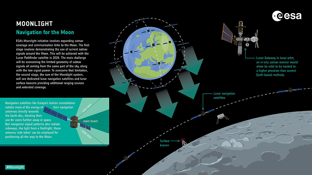
    ESA is going to the Moon — in collaboration with its international partners — and seeks to build a lasting lunar link to enable sustainable space exploration.

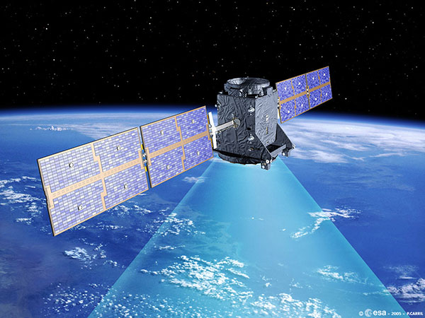
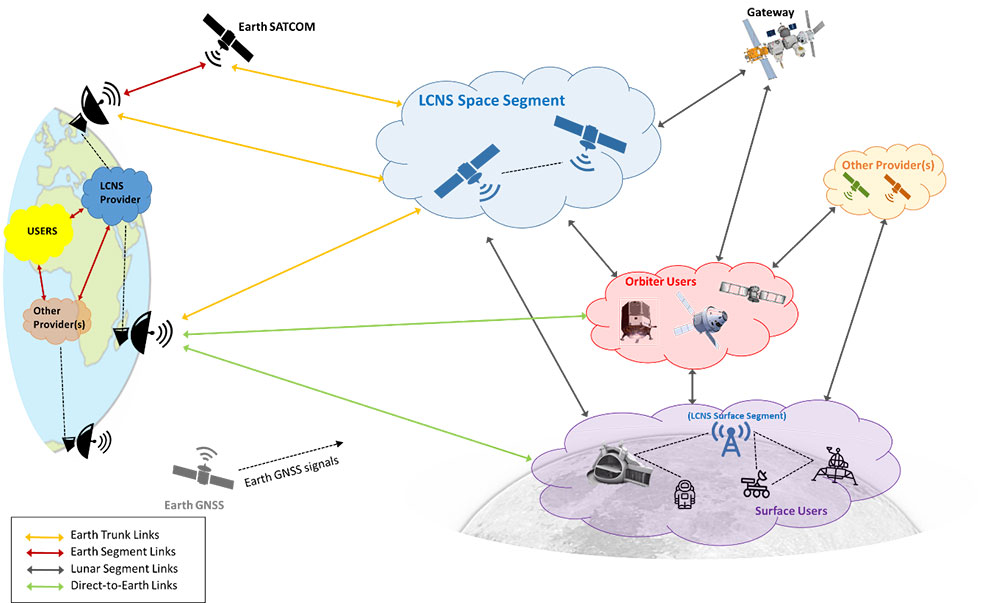
    The agency has now evaluated initial ideas to create a network of lunar telecommunications and navigation satellites.

    Creating a commercial telecommunications and navigation service for the Moon will allow many of the dozens of planned lunar missions to share the same infrastructure to communicate with Earth, as well as to find their way on the lunar surface.

    The service is needed because the planned missions are becoming regular trips to Earth’s natural satellite rather than one-off expeditions.

    Using a shared telecommunications and navigation service will reduce the design complexity and weight of individual missions, making them more cost-efficient.

    Lowering the ticket price to lunar exploration could also empower a wider group of ESA member states to launch their own national lunar missions, inspiring the next generation of scientists and engineers.

    Call for Ideas

    The call for ideas for how to use a lasting link with the Moon is open until April 30. People working for commercial companies, universities or governmental organizations are welcome to suggest how they would like to use a lunar communications and navigation service.

    This diagram presents a notional preliminary top-level system concept for a lunar communications and navigation service. (Image: ESA)
    This diagram presents a notional preliminary top-level system concept for a lunar communications and navigation service. (Image: ESA)

    Concept Reviews Completed

    Two consortia of companies have now completed their system concept reviews, which set out how to create the lunar constellation, under ESA’s Moonlight initiative to identify the best way to create a lasting link with the Moon. The reviews set out the business and technical analysis needed to identify and justify a number of feasible system concepts for creating the lunar network.

    The next step will be to define a detailed system architecture and identify the most suitable partnership models between private space companies and ESA.

    Telespazio leads the first consortium. The consortium includes:

    • satellite operators Inmarsat and Hispasat
    • manufacturing companies such as Thales Alenia Space Italy, OHB System in Germany and Canadian space technology company MDA
    • Italian Aerospace Logistics Technology Engineering Company (ALTEC)
    • small and medium-sized enterprises such as Nanoracks Europe and Argotec
    • universities and research centers such as SEE Lab, SDA Bocconi and Politecnico di Milano.

    The second consortium is spearheaded by Surrey Satellite Technology Limited, both in the service prime capacity through its lunar services brand SSTL Lunar and as the satellite manufacturer. The consortium includes:

    • satellite manufacturer Airbus
    • satellite network providers SES, based in Luxembourg, and Kongsberg Satellite Services, based in Norway
    • the Goonhilly Earth Station in the UK
    • British satellite navigation company GMV-NSL.

    Artemis Program and Pathfinder

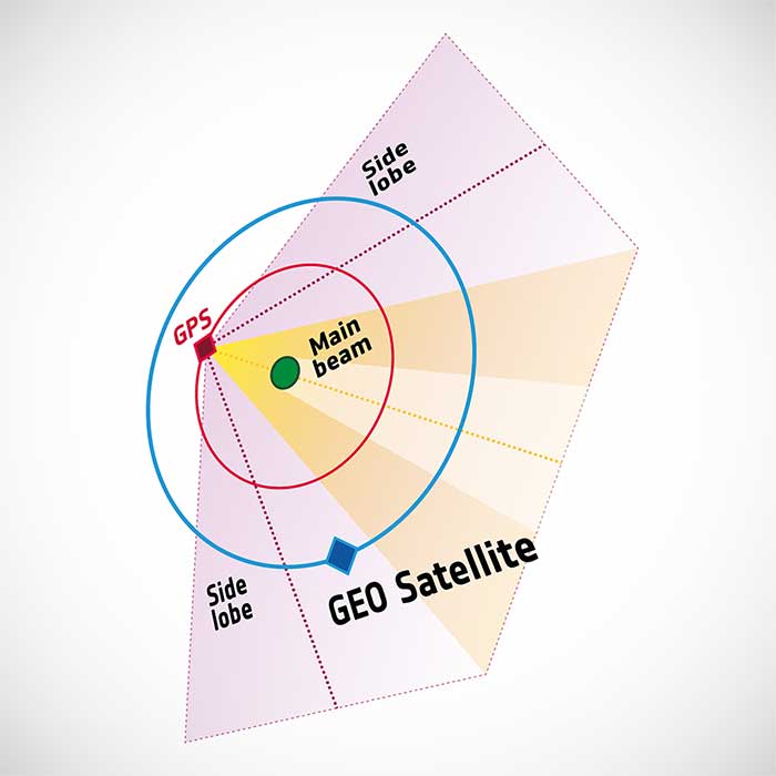
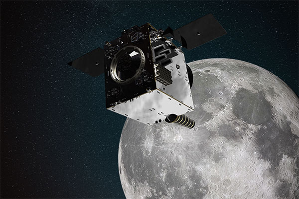
    NASA’s Artemis program will use several of ESA’s service modules to return humans to the Moon, including the ESPRIT communications module for the lunar Gateway’s living quarters for astronauts. With its European industrial partner, ESA is helping to build the Lunar Pathfinder, showcasing lunar communications service provision by providing initial services to early lunar missions, including a complete lunar navigation in-orbit demonstration.

    The Moonlight initiative builds on both the ESPRIT communications module and the Lunar Pathfinder.

    Infographic: ESA
    Infographic: ESA
  • ESA app turns smartphones into space monitoring tools

    ESA app turns smartphones into space monitoring tools

    Image: ESA
    Image: ESA

    A new Android app released by the European Space Agency (ESA) turns smartphones equipped with dual-frequency GNSS receivers into instruments for crowdsourced science.

    The CAMALIOT app, developed through ESA’s Navigation Innovation and Support Programme (NAVISP) with the support of the GNSS Science Support Centre, is suitable for more than 50 smartphone models.

    Using the CAMALIOT app, the phones will record small variations in satellite signals, gathering data for machine learning analysis of meteorology and space weather patterns.

    As well as helping to create new Earth and space weather forecasting models, participants are also in with the chance to win prizes including new phones and Amazon vouchers. This four-month “citizen science” campaign runs until the end of July.

    “The precisely modulated signals continuously generated by the dozens of GNSS satellites in orbit are proving a valuable resource for science, increasingly employed to study Earth’s atmosphere, oceans and surface environments,” said ESA navigation engineer Vicente Navarro. “Our GNSS Science Support Centre was created to help support this trend.”

    For instance, tens of thousands of permanent GNSS stations are continuously recording GNSS data. As the satellite signals travel down to Earth they are modified by the amount of water vapor in the lower atmosphere, helping to forecast rainfall in particular.

    GNSS signals also undergo delay and fading — known as scintillation — as they pass through irregular plasma patches in the ionosphere. This electrically charged upper atmospheric layer is continuously changing, influenced by solar activity, geomagnetic conditions and the local time of day. Dual-frequency GNSS receivers can compensate for this effect by comparing their two frequencies.

    “The combination of Galileo dual band smartphone receivers and Android’s support for raw GNSS data recording is what opened up the prospect of supplementing data from these fixed GNSS stations with tens of millions of smartphones, vastly increasing our density of coverage,” Vincente said. “We took inspiration from the famous ‘SETI@home’ initiative, where home laptops help seek out signs of extraterrestrial life.”

    The results can then undergo a Big Data machine learning approach, seeking out previously unseen patterns in both Earth and space weather.

    “This is our first step in enlarging GNSS data acquisition using an internet of things data-fusion approach, employing novel sources such as fixed sensors and drones as well as smartphones,” Vincente said. “A wide range of other applications are also possible for the system, including improving the performance of GNSS systems.”

    Formally known as the Application of Machine Learning Technology for GNSS IoT Data Fusion project, CAMALIOT is run by a consortium led by ETH Zurich (ETHZ) in collaboration with the International Institute for Applied Systems Analysis (IIASA).

    “The CAMALIOT effort was underpinned by Element 1 of our NAVISP research programme, spurring innovation in satellite navigation,” said Pierluigi Mancini, ESA’s NAVISP program manager.

  • Space Codesign obtains ESA/NAVISP funding for spaceborne GNSS receiver

    Space Codesign obtains ESA/NAVISP funding for spaceborne GNSS receiver

    Space Codesign logoSpace Codesign Systems has received funding from the European Space Agency (ESA) to support the design of a spaceborne GNSS receiver. The company is a provider of an end-to-end automated solution, from high-level application specification to physical board compilation.

    The spaceborne receiver will target system-on-chip (SoC) field programmable gate arrays (FPGA). SpaceStudio software by Space Codesign Systems is a development environment that eases the design flow of advanced algorithms targeting FPGA technology without the inherent complexity of FPGA.

    In avionic systems, transition from federated avionics architectures to integrated modular avionics (IMA) is observed. IMA architectures provide a shared computing platform, communications, and input/output resource pool that is partitioned by multiple tasks of differing design assurance criticalities. A similar transition is occurring in the world of satellite systems.

    “The main objective of the project is to add features to explore different architectures and hardware/software partitions for spaceborne GNSS receivers, such as [for] GPS and Galileo, operating in both low Earth orbits (LEOs) and high Earth orbits (HEOs),” said Guy Bois, founder,  Space Codesign System.

    The project will also support the XtratuM Next Generation (XNG) hypervisor for mixed-criticality systems in the virtual platform offered by SpaceStudio, where multiple tasks with different criticality and certification assurance levels are integrated using a shared computing platform.

    The funding is under ESA’s Navigation Innovation and Support Programme (NAVISP) Element 2,  made possible thanks to the Canadian Space Agency’s participation in the NAVISP. NAVISP is an optional program of ESA initiated in 2017 to support the generation and introduction of innovation in various positioning, navigation and timing (PNT) market segments. The main goal of NAVISP is to generate innovative concepts, techniques and systems linked to the highly competitive and evolving global market for PNT technologies. Element 2 continues to demonstrate its relevance, with more than 120 projects incubated so far.

  • ESA Navigation Lab showcases multi-receiver UAV

    ESA Navigation Lab showcases multi-receiver UAV

    Photo: ESA
    Photo: ESA

    The Navigation Laboratory of the European Space Agency (ESA) has acquired an unmanned aerial vehicle (UAV) that can carry different types of satellite navigation receivers to collect data for follow-on analysis.

    The NavLab, based at ESA’s ESTEC technical centre in Noordwijk, the Netherlands, is focused on the testing, analysis and characterization of navigation systems for both ESA and external customers.

    With UAVs representing a rapidly expanding user base, the new UAV is a timely addition to the NavLab’s suite of platforms for testing GNSS technologies and techniques, ESA said. Other tools include static, mobile and pedestrian platforms and a pair of test vans.

    Along with receivers and antennas, the UAV can host radio-frequency spectrum samplers and support equipment such as inertial sensors and stereo cameras, allowing the assessment of performance in specific dynamics and environments related to UAV applications, such as approach, landing, flying beside buildings or indoors.

  • Europe’s Project NAV-SSHE to demo GNSS + 5G for critical applications

    Europe’s Project NAV-SSHE to demo GNSS + 5G for critical applications

    NAV-SSHE logoThe Navigation Sensor Switching in Hostile Environments (NAV-SSHE) project aims to design, prototype and demonstrate new solutions for positioning, navigation and timing using 5G plus GNSS for critical applications in hostile environments. NAV-SSHE is supported by the European Space Agency (ESA).

    Geolocation company M3 Systems Belgium is taking part in the project in collaboration with Telespazio Belgium. The project began in September 2021 and will last until January 2023.

    In the context of NAV-SSHE, M3 Systems Belgium will implement both a GNSS and a 5G signal based on positioning engines. The output of both engines will be fused to provide a unique solution with increased robustness.

    The complete system will be demonstrated on two real-use cases:

    • autonomous vehicles on an airport platform (specifically autonomous lawn mowers)
    • autonomous docking of vessels in port

    The demonstrations will also be used to test potential use of these technologies for drone applications — specifically for the navigation system of the autonomous remotely piloted aircraft Boreal.

  • Massive global map provided free from MapTiler

    Massive global map provided free from MapTiler

    MapTiler has created a single image of the entire world detailed enough to find a specific house. If printed, the map would cover nearly 16 soccer fields.

    To create the world image, satellite imagery was processed to remove clouds and balance shades and tones, and then carefully stitched together to create a seamless map layer with beautiful colors. The input data is recent, from 2020 and 2021, and rendered as one tiled file with zoom levels 0-13 for use in web applications.

    Crafted by a small Swiss/Czech team, it is a viable, up-to-date alternative to Google maps for software developers, without privacy issues. It is available including seamlessly merged, super-high resolution aerial images for selected countries. The imagery provides more detail when users zoom beyond the satellite data.

    The map’s cloud-free satellite imagery is useful for real-estate websites, mobile apps, globes, games, virtual worlds, in airplane infotainment systems, and for TV news and weather. In addition, scientists and artists can download it for their own innovations and creations.

    In all, 180 terabytes of imagery have been crunched to fit on a 512-gigabyte USB stick.

    MapTiler has a history of collaborating with the European Space Agency (ESA) and its Copernicus Earth observation project, and has won two Copernicus Masters Awards. Working in ESA’s Business Incubation Center also boosted the company’s ability to adapt satellite imagery into useful data.

    Learn more on MapTiler’s blog.

    Image: MapTiler
    Image: MapTiler
  • Ireland’s danalto to demonstrate indoor positioning for ESA

    Ireland’s danalto to demonstrate indoor positioning for ESA

    Danalto was visited by Ireland’s Minister Damien English upon the announcement of ESA contract. (From left) English, Mary Kathryn Midgett (danalto), Tom Kelly (Enterprise Ireland) and David McDonald (danalto). (Photo: Danalto)
    Danalto was visited by Ireland’s Minister Damien English upon the announcement of an ESA contract. (From left) English, Mary Kathryn Midgett (danalto), Tom Kelly (Enterprise Ireland) and David McDonald (danalto). (Photo: danalto)

    Dublin-based danalto Ltd., has won a contract with the European Space Agency (ESA) to demonstrate low-infrastructure indoor location technologies that complement GNSS, particularly Galileo. ESA seeks to improve this European capability in order to enable impactful, societal use cases, thus prompting its call for this investigation, assessment, and demonstration by danalto.

    Danalto is a internet of things (IoT) software company specializing in positioning and spatial intelligence technologies. It has extensive experience in positioning intelligence with its FiLo, a LoRa 2.4 GHz-enabled solution known for both its low power and low infrastructure requirements.

    During the 18-month contract, danalto will determine the best positioning technology, system algorithms and deployment aspects across a range of location accuracies. This will be done by critically analyzing both classic (observables-based) and disruptive (signal-based) positioning techniques, culminating in a hybrid combination technology solution.

    The resulting solution will support use cases across multiple industries — including healthcare, logistics and emergency services — and will accelerate the increased adoption of location positioning solutions within the European market and beyond. The trajectory of this project aligns with danalto’s progression plan for next generation positioning solutions, which will be brought to market for commercial use in 2022.

    On Oct. 27, danalto was visited by Minister Damien English and Enterprise Ireland for a briefing on FiLo’s progress to date and plans moving forward aligned with ESA and beyond.


  • First UK-generated satnav signal coming in test project

    First UK-generated satnav signal coming in test project

    Satellite communications company Inmarsat is working on a United Kingdom Space Agency-funded test project with the European Space Agency to deliver the first UK-generated satellite navigation signal. The project provides a potential platform for the UK to enhance its post-Brexit positioning, navigation and timing (PNT) capabilities.

    Other partners are British companies Goonhilly Earth Station Limited and GMV NSL Limited.

    Repurposing a transponder from the Inmarsat-3 F5 satellite, the test project — known as UK Space-Based Augmentation System (UK SBAS) — will provide an overlay signal to augment the U.S. GPS, refining its accuracy from a few meters to a few centimeters.

    UK PNT without EGNOS

    The UK no longer has access to the European Geostationary Navigation Overlay Service (EGNOS) Safety of Life services since leaving the European Union (EU) and is not involved in the EU’s Galileo programme for similar reasons. Therefore, this new national capability supported by current and future Inmarsat satellites could offer a new option for high-integrity, precision navigation across the country, in its airspace and within surrounding waters.

    UK SBAS will provide a basis to assess its future development into an operational capability to support safety-critical applications such as aircraft approaching and landing at airports or navigating ships through narrow channels, especially at night and in poor weather conditions.

    Goonhilly will provide the uplink for the system from Cornwall. Software from GMV NSL, based in Nottingham, will generate the ground-based navigation signal. This is a similar system to that already in use in Australia and New Zealand, supported by Inmarsat.

    The project could be crucial for UK users who need accurate, high-integrity navigation capabilities to enable their operations. It will initially cover aviation and maritime operations, but has the potential to extend into rail and other land-vehicle applications. For example, UK SBAS will comply with International Civil Aviation Organization (ICAO) standards.

    “It is very welcome news to hear that UK-based companies have teamed up to deliver this ground-breaking project, with help from government funding,” said Transport Minister Trudy Harrison. “From flying planes to steering ships, reliable and precise navigation support is a crucial part of travel. This development is a significant step forward for our world-leading space sector, as we accelerate towards a net-zero transport future.”

    Best satellite candidate

    Artist's impression of an Inmarsat-3 satellite. (Image: Inmarsat)
    Artist’s impression of an Inmarsat-3 satellite. (Image: Inmarsat)

    The Inmarsat-3 F5 satellite is in geosynchronous orbit at 54° west, ensuring that its signal covers the UK as part of its Atlantic Ocean region service overlay. This makes it an ideal candidate to participate in the test. The satellite was manufactured by Inmarsat’s Athena partner Lockheed Martin and launched in 1998.

    “This project demonstrates British innovation at its best,” said Nick Shave, vice president of Strategic Programmes for Inmarsat Global Government. “Working with Goonhilly Earth Station and GMVNSL, supported by UK funding via the ESA Navigation Innovation and Support Programme (NAVISP), enables us to extend the long life of Inmarsat’s I-3 F5 satellite with additional new services designed two decades after launch.

    “We look forward to exploring the potential for this project and the benefits it could deliver to the UK with more precise, high-integrity, resilient navigation services, whilst also exploring future capabilities on new satellites through Inmarsat’s fully funded technology roadmap,” Shave said. “This work also has the potential to be exported to other nations around the world, benefitting the UK economically as well as technologically.”

  • Javier Benedicto to lead ESA’s Navigation Directorate

    Javier Benedicto to lead ESA’s Navigation Directorate

    Authors Javier Benedicto (ESA), left, and Rodrigo da Costa (GSA). (Image: ESA)
    Javier Benedicto, left, with EUSPA’s Rodrigo da Costa. (Image: ESA)

    Javier Benedicto will become the director of Navigation for the European Space Agency (ESA) on Feb. 16, 2022, when current director Paul Verhoef retires.

    Verhoef has served as director for almost six years, after a 40-year career spanning the European Commission, ESA and private industry.

    Benedicto is now head of the Galileo Programme Department within the Directorate of Navigation at ESA. A Spanish national, he spent his early career in academia, working as a microwave engineer at the Polytechnical University of Catalonia in Barcelona and as a telecommunications engineer at MIER Comunicaciones, also in Barcelona, before joining ESA in 1990. He is also a GPS World author, keeping readers apprised on the status of the Galileo program.

    He holds a master’s degree in science and telecommunications engineering from the Polytechnic University of Catalonia and has more than 100 publications in technical journals and conferences. He also holds three international ESA patents and has five honors and awards.

    Benedicto’s new role was announced Oct. 21, when the ESA Council appointed three new ESA directors. In addition to Benedicto as director of Navigation, Géraldine Naja will lead the new Directorate of Commercialisation, Industry and Procurement. Simonetta Cheli will succeed Josef Aschbacher as Director of Earth Observation Programmes; Aschbacher became ESA Director General in March 2021.

  • Spire to develop flexible geolocation signal-processing tools for ESA

    Spire to develop flexible geolocation signal-processing tools for ESA

    Spire logoSpire Global has been awarded a contract under the European Space Agency’s (ESA) Navigation Innovation and Support Programme (NAVISP), specifically “Element 2 – Competitiveness in PNT.” The contract is funded by the United Kingdom Space Agency.

    Spire will work with NAVISP to build on the current capabilities of the Spire constellation and develop tools needed for geolocation signal processing, which will be applied toward geolocating GNSS interference sources coming from the Earth’s surface.

    Spire’s low-Earth orbit (LEO) nanosatellite technology will be used to collect suspect interfering RF signals from a range of geographic areas prone to disruptions. Using advanced processing algorithms, the project will develop a suite of geolocation signal collection and processing techniques (including single and multi-satellite) to detect and characterize signals from a variety of interference scenarios.

    NAVISP Element 2 emphasizes maintaining and improving the capability and competitiveness of the position, navigation and timing (PNT) industry and its technologies and services in the global satellite navigation market. In recent years, PNT services have become ubiquitous and relied on by industry and critical national infrastructure such as telecommunications, emergency services, energy, finance, food and transport. The GNSS signals used in these applications are vulnerable to interference, which can disrupt PNT services.

  • Galileo prototype GIOVE-A switched off after 16 years in orbit

    Galileo prototype GIOVE-A switched off after 16 years in orbit

    Artist's rendering of GIOVE-A in orbit. (Image: ESA)
    Artist’s rendering of GIOVE-A in orbit. (Image: ESA)

    News from the European Space Agency

    Europe’s first prototype satellite for Galileo, GIOVE-A, has been formally decommissioned after 16 years of work in orbit. The GIOVE-A mission in 2005 secured Galileo’s radio frequencies for Europe, demonstrated key hardware, and probed the then-unknown radiation environment of medium-Earth orbit.

    “If not for GIOVE-A, the 26 Galileo satellites in orbit today would not exist,” said Paul Verhoef, ESA’s director of navigation. “Its speedy development and launch opened the way for our working constellation to follow.”

    ESA had begun designing Galileo at the turn of the century, and radio frequencies had been set aside for the new system by the International Telecommunications Union. But these frequency filings came with a deadline attached: the frequencies had to be used from orbit by mid-2006 or they would lapse.

    GIOVE-A was launched by Soyuz from Baikonur cosmodrome in Kazakhstan on Dec. 28, 2005. (Photo: ESA)
    GIOVE-A was launched by Soyuz from Baikonur cosmodrome in Kazakhstan on Dec. 28, 2005. (Photo: ESA)

    GIOVE-A Sped to Orbit

    Galileo In-Orbit Validation Element-A, or GIOVE-A, was produced at a breakneck pace to meet this deadline. Developed in the second half of 2003, the satellite was designed, built and tested before the end of 2005, and launched on Dec. 28 of that year.

    “At the time there was a lot of uncertainty: Would we make it or not?” recalled Javier Benedicto, head of the Galileo Project Department, ESA. “GIOVE-A transmitted its first Galileo signal-in-space on Jan. 21, 2006, meaning that Europe was formally in the navigation business.”

    That March, ESA formally confirmed it had brought the Galileo-related frequency filings into use, three months ahead of the official ITU deadline.

    Europe's first navigation satellite GIOVE-A, short for Galileo In-Orbit Validation Element-A, during flight preparation. (Photo: ESA)
    Europe’s first navigation satellite GIOVE-A, short for Galileo In-Orbit Validation Element-A, during flight preparation. (Photo: ESA)

    The mission also carried a prototype rubidium atomic clock — proving its functionality for the operational Galileo satellites that would follow — as well as a radiation instrument. Medium Earth orbit, 23,000 km altitude, was terra incognita at this point for European satellites, but it was known to possess enhanced radiation levels from the impinging of the outer band of Earth’s Van Allen radiation belts.

    A second Galileo prototype, GIOVE-B, followed in 2008, this time hosting a prototype passive hydrogen maser — the second type of atomic clock that Galileo relies on — along with an enhanced payload able to transmit for the first time the GPS-Galileo common signal.

    GIOVE-A Succeeded at New Mission

    Once the first Galileo satellites were in orbit and working well, ESA ended use of GIOVE-A in 2012. The satellite was placed in a graveyard orbit 100 km above the operational satellites’ orbits, as was GIOVE-B after its own four-year mission.

    Control of GIOVE-A passed to manufacturer Surrey Satellite Technology Ltd (SSTL) in the United Kingdom. GIOVE-A was then employed for various in-orbit experiments, including demonstrating the reception of satellite navigation signals from GPS satellites orbiting below it — based on spillover sidelobe reception from satellites on the other side of Earth.

    GPS satellites — like those of Galileo, Russia’s GLONASS or their Japanese, Chinese and Indian counterparts — aim their antennas directly at Earth. Any satellite orbiting above the GPS constellation can only hope to detect signals from over Earth’s far side, but the majority are blocked by the planet. For a position fix, a satnav receiver requires a minimum of four satellites to be visible, but this is most of the time not possible if based solely on front-facing signals. Instead, GIOVE-A has been able to make use of signals emitted sideways from GPS antennas, within what is known as "side lobes." Just like a flashlight, radio antennas shine energy to the side as well as directly forward. (Image: ESA)
    GIOVE-A was able to make use of signals emitted sideways from GPS antennas, within what is known as “side lobes.” (Image: ESA)

    This proof that satnav can be relied on further out into space means that satellites in geostationary orbit are making use of satnav for positioning. As a next step, ESA is planning to extend satnav coverage all the way to the Moon.

    The satellite also continued its radiation survey of medium-Earth orbit, acquiring a unique record extending across more than 10 years, analyzed by the Surrey Space Centre with ESA support. Multiple scientific papers have been written on these results, which encompass the “electron desert” of 2008-9 during the lowest levels of solar activity of the space era, followed by one of the largest electron storm events on record in April 2010.

    A new model of the outer Van Allen belt electron fluxes, MOBE-DIC, has been produced from this dataset, helping to guide future satellite designs.

    “Actually, the satellite itself is still operating well,” said Sarah Lawrence, SSTL. “The reason for ending the mission is software obsolescence in our control center. The decommissioning procedure involved transitioning the satellite to Earth-pointing mode, turning off the reaction wheels and setting the attitude and orbit control system to standby mode, before finally switching off the on-board computer and transmitter.”

    “GIOVE-A over-delivered on its original lifetime and mission goals – an inspiring and game-changing mission on so many levels,” said Martin Sweeting, SSTL executive chairman.

    SSTL went on to provide navigation payloads for operational Galileo satellites. Today, 26 Galileo satellites orbit the Earth. Galileo has become the world’s most precise satnav system, delivering meter-scale accuracy to more than 2.3 billion users around the globe.

    Two more Galileo satellites are being readied for launch Dec. 2.

  • Galileo Control Segment upgrade ready for next launch

    Galileo Control Segment upgrade ready for next launch

    Galileo Control Centre in Oberpfaffenhofen, Germany. (Photo: ESA)
    Galileo Control Centre in Oberpfaffenhofen, Germany. (Photo: ESA)

    News from the European Space Agency (ESA)

    The 11th launch of Galileo satellites, planned for Dec. 1, marks an important program milestone. With an upgrade of the Galileo Control Segment (GCS), this will be the first launch where the satellites’ first steps into space will be overseen from the Galileo Control Centre in Oberpfaffenhofen, Germany.

    Up until now, the Launch and Early Operations Phase (LEOP) of Galileo satellites has been overseen from an external mission control site — either ESA’s ESOC control centre in Darmstadt, Germany, or French space agency CNES’s site in Toulouse, France.

    The demanding upgrade of the GCS to Version 3.0 was performed by an industrial consortium led by GMV in Spain. The control segment encompasses the two Galileo Control Centres in Oberpfaffenhofen in Germany and Fucino in Italy, as well as six Telemetry, Tracking and Control (TT&C) ground stations used to monitor and command the 26 Galileo satellites in orbit.

    As well as increasing overall reliability and cybersecurity, the new upgrade opens the way to significant expansion of the Galileo constellation, enabling oversight of up to 38 satellites.

    Over the last three years, a complete technological refresh of the GCS software and hardware was done, including porting of software modules corresponding to several million lines of code, the deployment of equipment at many Galileo sites, and the execution of a rigorous level of testing throughout all elements comprising the system.

    Commencing in mid-2018, the upgrade had to contend with the worldwide COVID-19 pandemic midway through its lifetime, but the team pushed on to conclude at the end of July. Since Aug. 4, it has been used to nominally operate all the satellites in the constellation.

    The project was overseen by ESA in its System Prime role managing Galileo’s design, development, qualification and deployment of future upgrades on behalf of the European Commission, Galileo’s owner.