Sentera LLC, a designer of sensors, software, and unmanned aerial vehicles (UAVs), has been granted a Section 333 exemption from the Federal Aviation Administration (FAA) to operate multiple types of commercially available UAVs. Applications for these systems include crop survey, infrastructure inspection, geospatial mapping and other aerial imaging missions.
“We are excited to receive the exemption,” said Sentera CEO, Eric Taipale. “While most exemption holders focus on providing revenue-generating flight services, Sentera flies primarily to demonstrate our products to customers and to gather and analyze aerial data which helps us enhance our OnTop Platform, a data management system designed specifically to support the thousands of images collected during a typical UAV flight.”
Sentera’s exemption for both fixed-wing and quadcopter UAVs ensures the company can capture a wide range of data types that are relevant to customer applications, including very high-resolution visual, multispectral, and thermal imagery, as well as specialized non-image information. Customers use Sentera input data to perform many tasks, such as developing planting and crop management advice for growers, building 3D models of buildings, structures, and terrain for asset owners, and monitoring environmental regulatory compliance for public agencies.
Comprehensive data management solutions are crucial to successful UAV inspections, asset audits, safety inspections, agriculture data collections, and point-cloud collection activities.
“Clients use a myriad of UAV-captured data types to increase safety, assess crop health, and boost ROI (return on investment),” explained Taipale. “Sentera already provides some of the most precise sensors and leading UAV solutions in the industry. Our Section 333 exemption allows us advance our OnTop Platform more rapidly, which ultimately helps our customers manage all of this data most efficiently.”
The FAA authorization allows Sentera to fly UAV platforms built by Lockheed Martin, DJI and Sentera.
The global commercial UAV market is expected to reach $2.07 billion by 2022, according to a new study by Grand View Research Inc.
Increasing applications in agriculture and law enforcement are expected to drive commercial UAV industry growth over the forecast period. Commercial drones are finding applications across various industry verticals globally. Every industrialized country in the world is making investments in drones, thus driving the scope and technological developments for applications in the commercial UAV market.
Drones are contemporary alternatives for activities where human life cannot be risked. Such drones find applications in various industrial verticals including military, homeland security, retail and agriculture. The demand is significantly higher for military applications, although commercial applications are progressively catching up.
Aviation regulatory bodies such as the Federal Aviation Administration (FAA) have imposed restrictions on the use of such drones taking into consideration the difficulties in managing such huge air traffic and the safety of the citizens. However, the FAA is known to be undertaking an initiative to accelerate the UAV approval process for public safety agencies and broaden access to civilian organizations for a variety of commercial, industrial and other applications.
Further key findings from the report suggest:
Rotary blade drones accounted for more than 70 percent of the global market share owing to their easy maneuverability and compact design. Moreover, such single and multi-rotor drones equipped with rotary blades have Vertical Take-Off and Landing (VTOL) abilities for applications, where there is limitation of space for fixed blade drones to take off. The development of advanced hybrid UAVs that operate on non-conventional sources of energy and nano, small miniature drones serve multiple applications across various industry verticals.
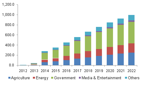
Government applications dominated the global commercial UAV industry constituting more than 40 percent of the market share in 2014. Increasing applications in law enforcement, security and surveillance, R&D activities, infrastructure, disaster management, and environmental studies have led to an increased demand for such unmanned aerial vehicles from the concerned government agencies. Innovative applications across agricultural sector have made it the fastest growing application segment, which is projected to grow at a CAGR of more than 18 percent from 2015 to 2022. Special agricultural drones can take snapshots of fields and help in analyzing crops. In addition, fix winged drones can be used for applications such as watering, spreading seeds, fertilizers, and pesticides over large farm fields that drastically reduce the time required and increase the efficiency.
North America is expected to grow at a CAGR of more than 16 percent over the forecast period on account of concentration of major drone manufacturers and increasing applications in the commercial sectors in the region. Governments and technology giants across the world are striving hard to provide internet to the people as a basic necessity. Facebook Inc. recently acquired Ascenta, a drone manufacturer for its pilot project to provide internet in remote areas using drones as movable wireless access points. Relaxation in regulations and increasing use of drones in law enforcement activities in Europe have led to the regional industry growth.
Major industry participants include AeroVironment Inc., BAE Systems, DJI, Elbit Systems, Parrot SA, Israel Aerospace Industries, The Boeing Company, and Textron Inc. Manufacturers resort to mergers and acquisitions as their key growth strategy to make their presence felt in the industry. Augmented funding, technological collaborations, and government agencies are expected to emerge as critical success factors for industry growth.
Grand View Research has segmented the global commercial UAV market on the basis of product, application, and region:
Commercial UAV Product Outlook (revenue, USD billion, 2012-2022)
Fixed wing
Rotary blade
Nano
Hybrid
Commercial UAV Application Outlook (revenue, USD billion, 2012-2022)
Agriculture
Energy
Government
Media & Entertainment
Others
Commercial UAV Regional Outlook (revenue, USD billion, 2012-2022)
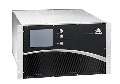
The U.S. Federal Aviation Administration (FAA) and NovAtel have exercised a bilateral option to produce a Wide Area Augmentation System (WAAS) G-III—Galileo prototype receiver. Maintaining core NovAtel WAAS G-III functionality for GPS and SBAS signal processing, the new receiver will operate in the WAAS reference station test environment to facilitate research on multiple GNSS constellation utilization.
The prototype receiver will also add functionality to support tracking and demodulating associated navigation data for Galileo satellites including:
Galileo E1 and E5a tracking
Ephemeris and almanac reporting/processing from E1 or E5a
Automatic channel assignments
Time solution computed from Galileo
Correlator information for signal deformation on Galileo signals
The WAAS G-III—Galileo prototype receiver will be developed on NovAtel’s existing WAAS G-III receiver hardware and application software, and delivered as a field-loadable firmware package. The WAAS G-III—Galileo receiver will not be qualified to DO-178B Level D as part of this contract.
NovAtel’s WAAS G-III reference receiver platform was designed with expandability and multi-GNSS SBAS evolution in mind, and can be customized to meet the needs of individual satellite networks. NovAtel has already delivered G-III based reference receivers to several programs worldwide, including the WAAS G-III receiver (US WAAS, FAA), IRIMS G-III receiver (India IRNSS, ISRO), and QZSS G-III receiver (Japan QZSS, NEC) variants.
The company’s reference receivers and uplink station equipment have been a central element of the U.S. WAAS since its inception. The WAAS third-generation reference receiver (G-III) uses fully updated hardware, and tracks all GPS signals including the legacy GPS L1 C/A, L2P(Y) (semi-codeless), and the modernized L2C, L5, L1C signals as well as the WAAS L1 C/A and L5 signals.
The WAAS G-III reference receiver provides a rich set of range measurement data, signal integrity metrics, and logs for processing by the system’s data communication processor, NovAtel said. The WAAS G-III – Galileo prototype receiver is the first G-III platform evolution for the FAA, an important step towards possible GPS + Galileo dual-GNSS SBAS operations in the future.
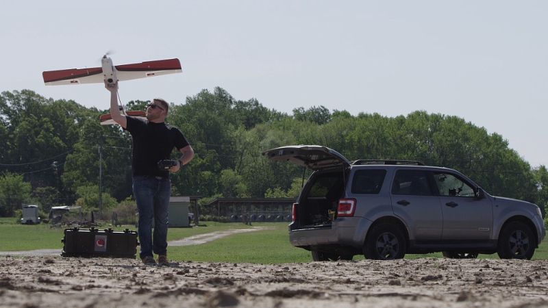
The Unmanned Aircraft Systems (UAS) Center has teamed up with the University of Cincinnati to conduct research and development on systems necessary to execute precision flight control algorithms for small UAS. Outcomes from this research are targeted to help emergency responders but may also be leveraged for other industrial purposes. The small UAS leased by the UAS Center is a rotocopter that weighs 15 pounds and has a payload capacity of 10 pounds.
The FAA granted a two-year Certificate of Waiver or Authorization to the Ohio/Indiana UAS Center and Test Complex. Testing of the aircraft will take place at Wilmington Air Park in Wilmington, Ohio.
“We will continue to support safe and cost effective research and development efforts across the state in partnership with the FAA, providing the foundation for this rapidly emerging industry,” said Ryan Smith, UAS director for the State of Ohio.
Once this technology is developed, the University of Cincinnati plans on transitioning it to industry. “The type of research being conducted right here in Ohio is what will help the UAS industry grow. Interested Ohio businesses can leverage this technology for commercial purposes,” Smith said.
The Association of Unmanned Vehicles Systems International (AUVSI) estimates the UAS market in Ohio is projected to be a 2 billion dollar industry with a potential to create 2,500 jobs over the next 10 years.
MAPPS has accepted an invitation from the Federal Aviation Administration (FAA) to be a member of the UAS Registration Task Force (RTF) Aviation Rulemaking Committee (ARC).
MAPPS is a national association of private-sector firms in the surveying, spatial data and geographic information systems field in the United States and a leader on the use of unmanned aircraft systems in the geospatial field.
The UAS RTF ARC was announced on Monday by Transportation Secretary Anthony Foxx to help minimize potentially unsafe UAS operations and incidents. The task force will work to develop minimum requirements for a UAS registration process for safe integration of UAS into the National Airspace.
MAPPS has tapped John Perry, founder and CEO of Altavian based in Gainesville, Fla., to represent the association on the task force.
“We are pleased and honored that the FAA has invited MAPPS to participate in the UAS RTF ARC,” said MAPPS President Susan Marlow. “MAPPS has actively called on the FAA to move forward with UAS rulemaking, and we are thrilled to be a part of the process.”
MAPPS has been a voice for the commercial use of UAS for geospatial data acquisition. The association has been engaged with FAA on UAS issues since 2009 and testified before state legislatures and participated in Congressional roundtables. MAPPS Executive Director John Palatiello was appointed to serve on the Federal Aviation Administration (FAA) working group on beyond visual line of sight (BVLOS) operations of commercial unmanned aircraft systems (UAS), and the association serves on a committee of the National Conference of State Legislatures (NCSL) to develop policy recommendations to the 50 state legislatures on UAS.
On Nov. 17-18, MAPPS will host sessions on geospatial activities at Drone World Expo, at the San Jose Convention Center in San Jose, Calif. The geospatial content will explore factors to consider when planning the start-up of a stand-alone UAS business, or a department in an existing surveying or mapping firm. It will kick off with a presentation on “What You Need to Know Before Starting Up Your Unmanned Aircraft System (UAS) Department,” as well as instruction on issues including system operating limitations, flight training, crew responsibilities, operator authority, client expectations, standards and licensing. Speakers at the policy conference will include Bryan Baker, UAS sales manager, Leica Geosystems; Jeff Lovin, senior vice president, director of Geospatial Services, Woolpert; Andy Nickerson of Aerovel Corp.; Mike Tully, president, Aerial Services, Inc.; and David Yoel, CEO, American Aerospace, Inc.
PrecisionHawk will serve as a technical resource to regulators. (PRNewsFoto/PrecisionHawk)
PrecisionHawk is contributing to a safety task force created by the U.S. Department of Transportation and the FAA. The task force brings together a diverse group, representing the UAS and manned aviation industries, the federal government, and other stakeholders, to develop an augmented registration process for Unmanned Aircraft Systems.
“PrecisionHawk is working on many safety solutions, procedural and technological, that we believe can contribute to safer operations for commercial drones in the national airspace,” said Ernest Earon, PrecisionHawk CTO and co-founder. “The creation of this task force further demonstrates the willingness of the FAA to move forward with industry leaders to promote rapid and safe integration.”
“As a UAS technology company and operator, we know how important coordinated identification is to the environments in which we work,” said Thomas Haun, VP of Strategy at PrecisionHawk. “The goal of this task force, to create a streamlined registration process for UAS, will have a direct and positive impact on the operations of our partners and service teams.”
“This task force presents another opportunity for PrecisionHawk to serve as a technical resource to regulators as we move towards the adoption of UAV regulations. Earlier this year PrecisionHawk was also named, alongside CNN and BNSF, to the FAA Pathfinder Program to test and develop technology solutions to solve beyond line of sight operations,” PrecisionHawk said in a statement.
New Task Force to Develop Recommendations by Nov. 20
WASHINGTON — U.S. Transportation Secretary Anthony Foxx and FAA Administrator Michael Huerta today announced the creation of a task force to develop recommendations for a registration process for Unmanned Aircraft Systems (UAS).
The task force will be composed of 25 to 30 diverse representatives from the UAS and manned aviation industries, the federal government and other stakeholders. The group will advise the department on which aircraft should be exempt from registration due to a low safety risk, including toys and certain other small UAS. The task force also will explore options for a streamlined system that would make registration less burdensome for commercial UAS operators.
The task force may make additional safety recommendations as it deems appropriate. Secretary Foxx directed the group to deliver its report by Nov. 20.
“Registering unmanned aircraft will help build a culture of accountability and responsibility, especially with new users who have no experience operating in the U.S. aviation system,” Foxx said. “It will help protect public safety in the air and on the ground.”
Every day, the FAA receives reports of potentially unsafe UAS operations. Pilot sightings of UAS doubled between 2014 and 2015. The reports ranged from incidents at major sporting events and flights near manned aircraft, to interference with wildfire operations.
“These reports signal a troubling trend,” Huerta said. “Registration will help make sure that operators know the rules and remain accountable to the public for flying their unmanned aircraft responsibly. When they don’t fly safely, they’ll know there will be consequences.”
While the task force does its work, the FAA will continue its aggressive education and outreach efforts, including the Know Before You Fly campaign and No Drone Zone initiatives with the nation’s busiest airports. The agency also will continue to take strong enforcement action against egregious violators. At the same time, it will continue working with stakeholders to improve safety to ensure further integration and innovation in this promising segment of aviation.
Secretary Foxx was joined by representatives from the following stakeholder groups:
UPDATE: Read news of the official announcement here.
The federal government is expected to announce today a new plan requiring anyone buying a drone to register the device with the U.S. Department of Transportation. The registration of the drone will enable authorities to track a drone back to its owner if used in a dangerous manner.
Under the plan, the DOT would work with the drone industry to set up a structure for registering the drones, and the regulations could be in place by Christmas.
The government has been concerned about the rise in close calls between unmanned drones and aircraft flying into and out of some of the nation’s biggest airports. In July, a passenger jet preparing to land at New York’s John F. Kennedy International Airport had a close call with a drone, which was 100 feet away from the jet at an altitude of 1,700 feet. Normal safe separation distance is between aircraft is at least 1,000 feet.
Private drones were also blamed for hampering aerial firefighting efforts over a California blaze in July. Firefighting aircraft trying to attack the fast-moving blaze in the Cajon Pass had to leave the area for around 20 minutes over safety concerns, officials said. That fire swept over a freeway and burned 20 vehicles.
On Oct. 6, the FAA announced the largest civil penalty proposed yet — $1.9 million — against a UAS operator for endangering the safety of the national airspace.
Brian Wynne, president & CEO of the Association for Unmanned Vehicle Systems International (AUVSI), released the following statement on today’s announcement that he is joining the U.S. Department of Transportation’s Task Force to develop a streamlined registration process for unmanned aircraft systems (UAS):
“AUVSI welcomes the opportunity to join this task force of government and industry stakeholders. This collaborative effort to develop an efficient process for UAS registration should lead to increased accountability across the entire aviation community.
“Under the FAA’s proposed small UAS rules released earlier this year, commercial operators would be required to register their platforms. Extending this requirement to other UAS users will help promote responsibility and safety.
“In addition to UAS registration, it is essential for the FAA to finalize its small UAS rules as quickly as possible. Once this happens, we will have an established framework for UAS operations, allowing anyone who follows the rules to fly. Considering that safety is at stake, time is of the essence to finalize the rules.
“Because safe operations are essential for all users of the national airspace, AUVSI is also looking forward to continuing its work with the FAA, the Academy of Model Aeronautics and more than two dozen supporters of the ‘Know Before You Fly’ campaign to educate newcomers to UAS technology about safe and responsible flying.”
Data is curated by SpecOut.com and sourced from the Center for the Study of the Drone at Bard College.
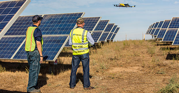
The Topcon Falcon 8 — powered by Ascending Technologies — is designed for inspection and monitoring, as well as survey and mapping applications.
“Along with our exemption for the Sirius fixed-wing system, the Falcon 8 exemption extends the Topcon UAS presence in the rotary-wing solutions market to be an even more powerful resource and provide demonstrations and training,” said Eduardo Falcon, executive vice president and general manager of the Topcon GeoPositioning Solutions Group. “Aerial data collection has a strong future in all the industries we serve, and the possibilities for survey, construction, agricultural, and emerging inspection applications are seemingly limitless.
“Building on the success the Falcon 8 has already seen in Europe, this exemption allows Topcon to expand on that momentum in the U.S. market,” said Falcon.
Last month I wrote about the drone industry experiencing giddy enthusiasm. One of the points I mentioned was the upcoming Commercial UAV Expo, in which there were predicted to be 100+ exhibitors and 500-700 attendees — an exhibitor-to-attendee ratio of 1:5-7, an unusually low ratio for a conference. At INTERGEO in September, from where I wrote last month’s column, the ratio was 1:31.
Well, I attended the Commercial UAV Expo in Las Vegas last week. The organizers reported ~1,500 attendees instead of the predicted 500-700. Apparently, attendance even surprised the organizers because they ran out of attendee bags by the time I picked up my badge the day before the conference began.
It was a very good conference because there were legitimate users and potential users of drone technology. During sessions, the audience was focused, more so than at most conferences I’ve attended. I think the reason is clear. The audience, consisting of drone users, potential users and manufacturers, wants to know where in the rapidly developing drone market is there a chance to make money?
One of the more interesting presenters was Commonwealth Edison, an electric utility based in Chicago with more than 5 million customers. ComEd discussed its experience and applications for drones from substation tower inspections to transmission line surveys. A representative from CNN, the news organization, spoke about how they are using drones to capture images and videos of breaking news events such as the recent refugee crisis in Europe. Chad Colby, a farmer who claims more than 3,500 drone flights and is active on the drone conference speaking circuit, showed the audience the value of drones in agriculture, which is one of the no-brainer markets for drones. Presentations such as these and a handful of others struck home with the audience because they present meaningful, that is to say monetizable content.
Commonwealth Edison’s use cases for drones.CNN use case for drones.Chad Colby/Nolan Berg describe the impact of drones in the ag market.
Moving from current uses to future uses, British Petroleum (BP) displayed its drone wish list — likely one that most drone dreamers would like to see:
Platforms (hardware/software):
Interoperability
Continuous operation
Autonomous air, land, water
Robots that can maneuver around a facility
Non-military pricing
Regulations:
Tech standards — iSafe, ANSI, HSAC
Beyond line of sight
Data exchange formats
Certification programs
Night operations
Payloads:
Miniaturized
Varied – full EM spectrum, acoustic, gas sensing
Several of the items on BP’s wish list were recurring themes at the conference, with the big elephant in the room being beyond-visual-line-of-sight (BVLOS). The Federal Aviation Administration (FAA) has largely not allowed BLOS operations even for 333 Exemption holders like me. Following is an excerpt from the CoA (Certificate of Waiver or Authorization) issued by the FAA:
d. The PIC is responsible to ensure visual observer(s) are: – Able to see the UA and the surrounding airspace throughout the entire flight
The Visual Line of Sight (VLOS) requirement seriously inhibits the value of drones for commercial use. When you consider that a rotorcraft (helicopter) might be less than two feet in diameter, it doesn’t have to travel very far before it’s difficult to see (without the aid of binoculars or similar devices, which are prohibited). However, rotorcraft are very flexible in that they can be controlled in a small area. They can hover and they can land in very small or constrained areas relatively safely. Fixed-wing (airplane) drones are a different story. At 30-50 miles per hour, it doesn’t take long for a fixed-wing drone to be out of VLOS. So, practically speaking, a fixed-wing drone for production-oriented flying is very limited, unless the operator disregards the FAA VLOS rule.
The other challenge with fixed-wing drones is the take-off, and more importantly, the landing space required to bring a fixed-wing drone back to earth in one piece. One fixed-wing manufacturer said you’ll need several hundred feet to land their aircraft, and that’s assuming a full payload (maximum weight). One has to wonder how fixed-wing drones will be deployed. One can quickly see how impractical it may be to launch a fixed-wing drone in something less than a city park, high school sports field or a crop field.
Ignoring the FAA VLOS (and other) rules is clearly what is happening. There is seemingly no constraint for manufacturers to tell prospective buyers “go ahead and operate on your own property, no one will care.” Farms, mining operations and some construction sites might be so rural that there’s not a human being in sight. In those scenarios, it seems the “no harm, no foul” rule is in effect, or more likely “don’t ask, don’t tell.” It’s definitely happening, to the point that critics are arguing that the FAA rules are so restrictive that it promotes illegal operations. Even a former NTSB (National Transportation Safety Board) member wrote an article entitled “Unreasonable UAS Rules Promote Culture of Non-Compliance”.
However, just when you think it’s a drone free-for-all to fly where you want, the FAA pulls one out of its hat like it did last week and proposed a $1.9M fine to a Chicago-based company, SkyPan International, for conducting 65 drone flights without authorization. Mind you, these weren’t flights in rural Iowa taking pictures of corn fields. According to the FAA, the company flew 43 missions in New York City’s restricted airspace without prior authorization. Well, now we know where the FAA’s tolerance lies.
Back to the Commercial UAV Expo. While the enthusiasm during the technical sessions showed some restraint, it knew no bounds in some areas of the exhibition area. Vendors, especially the venture capital-funded ones, were looking to book orders now. Prices ranged from sub-$1,000 for a “prosumer” drone for snapping high-resolution images to a $100,000+ for the drone equipped with lidar or other specialized payload.
The exhibit hall at the Commercial UAV Expo.
Please don’t take my message the wrong way. There’s a lot of opportunity for drones in the commercial market segments, from agriculture to utility inspection to photography — but the game is very early. While the technical hurdles can be conquered, the regulatory hurdles are substantial. The FAA is working on rules for BVLOS, but as the FAA chairman said, a solution for that is a few years from now.
The Federal Aviation Administration (FAA) has entered into a Pathfinder agreement with CACI International Inc. to evaluate how the company’s technology can help detect Unmanned Aircraft Systems (UAS) in the vicinity of airports.
In testimony today before the House Aviation Subcommittee, FAA Deputy Administrator Mike Whitaker said that flying an unmanned aircraft near a busy airfield poses an unacceptable safety hazard. During the hearing “Ensuring Aviation Safety in the Era of Unmanned Aircraft Systems,” Whitaker told the congressional panel the FAA signed an agreement this week to assess the safety and security capabilities of CACI’s product within a five-mile radius of airports, and the agency also will collaborate with its government partners.
A steep increase in reports of small unmanned aircraft in close proximity to runways is presenting a new challenge for the FAA. It is the agency’s responsibility to identify possible gaps in safety and address them before an incident occurs.
CACI’s prototype UAS sensor detection system will be evaluated at airports selected by the FAA. The agency and its federal government partners will work with the company to evaluate the effectiveness of the technology, while also ensuring that it does not interfere with the safety and security of normal airport operations.
The CACI partnership is part of the larger UAS Pathfinder Program, which the FAA announced in May. Pathfinder is a framework for the agency to work closely with industry to explore the next steps in unmanned aircraft operations beyond those proposed in February in the draft small UAS rule.
“Safety is always the FAA’s top priority, and we are concerned about the increasing number of instances where pilots have reported seeing unmanned aircraft flying nearby,” said Whitaker. “We are looking forward to working with CACI and our interagency partners to identify and evaluate new technologies that could enhance safety for all users of the nation’s airspace.”
“CACI is proud to partner in the FAA’s Pathfinder cooperative research and development agreement to address the escalating Unmanned Aircraft Systems safety challenges that airports are facing nationwide,” said John Mengucci, CACI’s CEO and president of U.S. operations. “The agreement provides a proven way to passively detect, identify, and track UAS — or aerial drones — and their ground-based operators, in order to protect airspace from inadvertent or unlawful misuse of drones near U.S. airports. This CACI-built solution will help ensure a safe, shared airspace while supporting responsible UAS users’ right to operate their aircraft.”
The U.S. Department of Transportation’s Federal Aviation Administration (FAA) has announced the largest civil penalty the FAA has proposed against a UAS operator for endangering the safety of the national airspace.
The FAA proposes a $1.9 million civil penalty against SkyPan International Inc. of Chicago. Between March 21, 2012, and Dec. 15, 2014, SkyPan conducted 65 unauthorized operations in some of the most congested airspace and heavily populated cities, violating airspace regulations and various operating rules, the FAA alleges. These operations were illegal and not without risk.
The FAA alleges that the company conducted 65 unauthorized commercial UAS flights over various locations in New York City and Chicago for aerial photography. Of those, 43 flew in the highly restricted New York Class B airspace.
“Flying unmanned aircraft in violation of the Federal Aviation Regulations is illegal and can be dangerous,” said FAA Administrator Michael Huerta. “We have the safest airspace in the world, and everyone who uses it must understand and observe our comprehensive set of rules and regulations.”
SkyPan operated the 43 flights in the New York Class B airspace without receiving an air traffic control clearance to access it, the FAA alleges. Additionally, the agency alleges the aircraft was not equipped with a two-way radio, transponder and altitude-reporting equipment.
The FAA further alleges that on all 65 flights, the aircraft lacked an airworthiness certificate and effective registration, and SkyPan did not have a Certificate of Waiver or Authorization for the operations.
SkyPan operated the aircraft in a careless or reckless manner so as to endanger lives or property, the FAA alleges.
SkyPan has 30 days after receiving the FAA’s enforcement letter to respond to the agency.