As hundreds of thousands of tourists flock to the Washington, D.C., area for their summer vacations and residents join them on city streets and at public gatherings, the Federal Aviation Administration has a clear message for everyone: Leave Your Drone at Home.
The FAA has announced a public outreach campaign for the region around Washington, D.C., to reinforce the message that the city itself, and communities within a 15-mile radius of Ronald Reagan Washington National Airport, are a “No Drone Zone.” The effort includes furnishing outreach materials to federal, state and local partners around the National Capital Region. The agency wants to ensure residents and tourists all understand that flying an unmanned aircraft in this area for any purpose is against the law.
The push follows two incidents when drones entered the no-fly zone around the White House. The most recent was on May 14.
Rules put in place after the 9/11 attacks establish “national defense airspace” over the D.C. area and limit aircraft operations — including unmanned aircraft — to those with an FAA and Transportation Security Administration authorization. Violators may face stiff fines and criminal penalties.
The bottom line: Enjoy your visit to the nation’s capital. Bring your family, your cameras and plenty of sunscreen. Just don’t bring your drone.
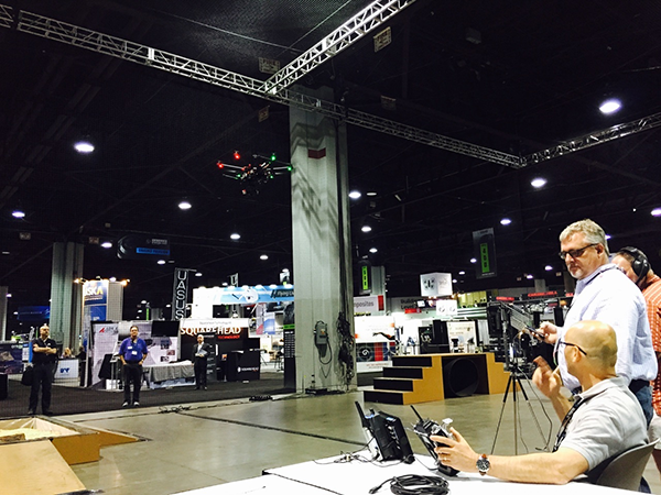
The Robotics in Action drone flying area at the AUVSI show.
The AUVSI show in Atlanta, held May 4-7, drew significantly more attention from TV media this year, as several of the major networks provided live coverage from the show floor. NBC’s Today morning show opened with a live shot of a drone hovering in front of an opening house door, as if patiently waiting to deliver a package from Google or Amazon — the potential good side of drones for consumers.
Then their coverage recalled the DJI drone crashing onto the White House front lawn in the early morning hours (perhaps an unfortunate loss of user control, but an odd time and place to be out flying a drone), and airline pilot reports of lighted drones appearing above nighttime final approach paths — the bad side of drones in common usage.
The Connex wireless system.
Then Brian Wynne, president and CEO of AUVSI, provided a positive insight on the latest forecasts of UAV’s contributing $82 billion to the U.S. economy. Wynne’s estimates included the generation of more than 100,000 new high-paying technical jobs within 10 years’ time. But in an effort to urge faster progress towards regulations, Wynne also suggested that for every day of delay in Federal Aviation Administration (FAA) rulemaking to allow open use of drones, the U.S. loses $27 million daily in economic impact.
There was similar encouraging coverage by Fox News from the Atlanta Convention Center show floor, followed by Brian Wynne again pitching for rapid introduction of commercial drone use in the U.S. Fox chose to broadcast from the Robotics in Action drone flying area, and to feature real-time, zero latency HD video transmitted via Amimon’s Connex wireless system. A good demo over live TV, and Amimon’s chance to tell the world about its wireless transmission system that can transmit HD video over up to half-a-mile away with zero latency — good news, incidentally, for Fox, NBC, CNN and other news gatherers.
This year, it also seems that the terminology battle with the U.S. media over the common usage of the term drone or drones, rather than the more accurate UAV or UAV, has been conceded. So now we can talk about drones no matter how much it pains us to do so.
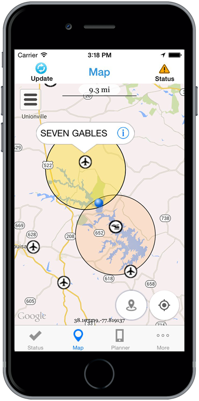
But the FAA is not standing still. Well over 200 Section 333 exemptions have now been granted to allow commercial UAS applications to undertake or investigate revenue-generating business. FAA representatives came to the show to let people know they are working hard to progress towards the safe use of drones in U.S. airspace. Through a media-only press-conference, the FAA announced the B4UFly smartphone app to inform recreational drone operators if it’s safe to fly. Features include:
A clear “status” indicator that immediately informs operators about their current or planned location.
Information on the parameters that drive the status indicator.
A “Planner Mode” for future flights in different locations.
Informative, interactive maps with filtering options.
Contact information for nearby airports.
Links to other FAA UAS resources and regulatory information.
The app will access the user’s location to automatically generate this information. There is also a planning mode for what data could be available for a potential future location to which you may be preparing to go.
But the main news from FAA Administrator Michael Huerta at the press conference was about the Pathfinder program, which involves three U.S. companies undertaking research with the FAA to expand unmanned aircraft operations in the United States. Each project has a key element where boundaries are being stretched to gain experience and to develop new capabilities to overcome restrictions for UAVs.
CNN (Cable News Network) will use visual line-of-sight (LOS) drone newsgathering in urban areas. There have previously been heavy restrictions in most of the Section 333 exemptions on operating in populated areas. So, it would seem that care will be taken in how news coverage will be generated around and over people, but the news will still be working to get the live overhead video we are now seeing more often on TV.
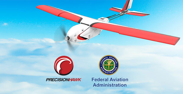
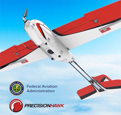
PrecisionHawk and BNSF Railway will investigate operations in rural areas, flying outside LOS. This is big news, as most UAV operators want to extend their areas of operation much further than visual LOS. In particular, Amazon has been most critical about LOS restrictions — the retailer wants package delivery to be virtually automated. But more on that later.
Beyond visual LOS, investigations in largely unpopulated areas by PrecisionHawk and BNSF could result in safe technology and procedures that could be commonly used in populated area for other operators. This is clearly the FAA’s desire, and of course, its intent is also to deflect earlier criticism of lack of progress in this area.
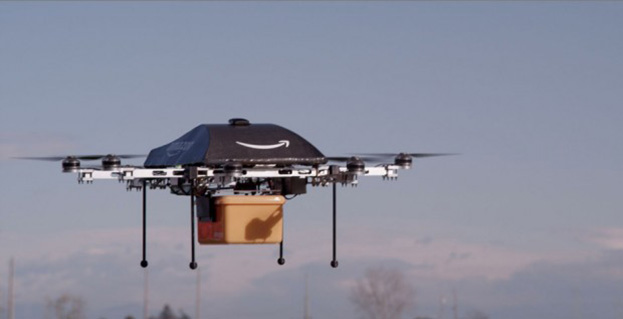
Onto Amazon. The company filed a UAV delivery patent with the U.S. Patent Office, where drone deliveries would be navigated by pulling location data from a customer’s smartphone — and real-time routes and directions would be constantly updated to guide the delivery process.
Amazon’s Prime Air “Delivery Drone.”
Amazon smart aircraft could interact between each other, passing on traffic and weather conditions. Delivery options for the consumer include a tool to deliver packages to your home, workplace or even to vacation locations.
Various safety precautions and caveats appear to have been appropriately addressed in the patent. Use of a number of sensors, including, radars, acoustic sensors and an infrared camera, are outlined in the patent to ensure safe navigation and landing. The patent also proposes a number of different types of unmanned aircraft with different shapes and weight for its delivery system.
And then on Tuesday, May 12, just after the AUVSI convention had wound down and left Atlanta, two U.S. senators jointly proposed a new bill that could expedite the commercial introduction of drones.
The senators believe the U.S. is falling behind other countries when it comes to creating rules for commercial drones. Sen. Cory Booker (D-N.J.) and Sen. John Hoeven (R-N.D.) introduced the Commercial UAS Modernization Act, which would set temporary rules for those who want to fly commercial unmanned aircraft systems before the FAA establishes permanent laws regarding drone use.
Sen. Corey Booker
The Commercial UAS Modernization Act outlines basic rules for commercial use around registration, certification, insurance, tests and safety. Operators would be required to keep the drones under 500 feet, fly only in daylight, and operate within visual line of sight (LOS). However, the proposal also creates a deputy administrator position that would be able to make an exemption for a commercial drone operator for beyond visual LOS and for “heavier unmanned vehicles.”
“Not later than 90 days after the date of the enactment of this Act, the Deputy Associate Administrator, in consultation with the Administrator, shall expedite and expand exemptions from the interim operating restrictions otherwise applicable to unmanned aircraft under section 337,” the act reads.
Sen. John Hoeven
When I talked with Sen. Hoeven this week, he emphasized that this bill seeks to accelerate the commercial use of drones in the U.S. and to make more use of the UAV test centers that the FAA has set up. These centers are capable of doing more, and can be the points that prospective drone operators visit to register their craft and take knowledge and proficiency qualification tests.
The bill gives tight timescales to the FAA to set up accessible locations to achieve registration and set up these operator qualification programs. In addition, the bill establishes a new deputy administrator position responsible for the safe integration of UAS in U.S. airspace, while also streamlining regulations that currently slow the industry’s ability to innovate new aircraft technologies.
In essence, the bill takes the core elements of the FAA’s past Section 333 approvals — less the requirement for a private pilot’s license — and makes them law. Operators would no longer need to ask the FAA for an exemption.
I asked Sen. Hoeven if the FAA has responded to the proposed bill, and he said he would be meeting with FAA Administrator Michael Huerta on May 14. “This follows their rules,” the senator said, so his message is let’s move forward together.
So, it would seem that momentum is at last gathering to overcome what would seem to be a lengthy period of FAA intransigence, including new innovative efforts by the agency itself to find ways to move forward more rapidly. Innovation in UAV technology, products and applications has been going on at a rapid pace, and the pent-up demand seems to be spilling over.
With more than 4,000 comments in hand for the FAA to deal with on its proposed rulemaking for small UAVs, it’s doubtful we’ll have any FAA regulations any time soon. So the Section 333 exemptions will probably continue, unless they are not totally overwhelmed by the new rules proposed by Senators Hoeven and Booker, who hope to see their bill approved sometime this year.
After a rigorous competition, the Federal Aviation Administration (FAA) has selected a Mississippi State University team as the FAA’s Center of Excellence for Unmanned Aircraft Systems (COE UAS). The COE will focus on research, education and training in areas critical to safe and successful integration of UAS into the nation’s airspace.
The team brings together 15 of the nation’s leading UAS and aviation universities that have a proven commitment to UAS research and development and the necessary resources to provide the matching contribution to the government’s investment.
“This world-class, public-private partnership will help us focus on the challenges and opportunities of this cutting-edge technology,” said U.S. Transportation Secretary Anthony Foxx. The Department of Transportation oversees the FAA. “We expect this team will help us to educate and train a cadre of unmanned aircraft professionals well into the future.”
The COE research areas are expected to evolve over time, but initially will include:
detect and avoid technology
low-altitude operations safety
control and communications
spectrum management
human factors
compatibility with air traffic control operations
training and certification of UAS pilots and other crew members, in addition to other areas.
“This team has the capabilities and resources to quickly get up and running to help the FAA address the demands of this challenging technology over the next decade,” said FAA Administrator Michael Huerta.
The FAA expects the COE will be able to begin research by September 2015 and be fully operational and engaged in a robust research agenda by January 2016.
Congress appropriated $5 million for the five-year agreement with the COE, which will be matched one-for-one by the team members.
In addition to Mississippi State University, the other team members include: Drexel University; Embry Riddle Aeronautical University; Kansas State University; Kansas University; Montana State University; New Mexico State University; North Carolina State University; Oregon State University; University of Alabama, Huntsville; University of Alaska, Fairbanks; University of North Dakota; and Wichita State University.
The FAA will determine the relationship between the new COE and the six UAS sites the FAA announced last year once the new team develops detailed research plans. The FAA expects COE flight testing to occur at one or more of the existing test sites.
Congress mandated that the FAA establish the COE under the Consolidated Appropriations Act of 2014. Like university think tank partnerships, the agency’s Centers of Excellence bring together the best minds in the nation to conduct research to educate, train and work with the FAA toward solutions for aviation-related challenges.
The U.S. Department of Transportation’s Federal Aviation Administration (FAA) today announced a partnership with industry to explore the next steps in unmanned aircraft operations beyond the type of operations the agency proposed in the draft small unmanned aircraft systems (UAS) rule it published in February.
“Government has some the best and brightest minds in aviation, but we can’t operate in a vacuum,” said U.S. Transportation Secretary Anthony Foxx. “This is a big job, and we’ll get to our goal of safe, widespread UAS integration more quickly by leveraging the resources and expertise of the industry.”
FAA Administrator Michael Huerta announced the initiative today at the Association for Unmanned Vehicle Systems International Unmanned Systems 2015 conference in Atlanta, Ga. See more coverage of the show from Geospatial Solutons.
The FAA is working with industry partners on three focus areas, including:
Visual line-of-sight operations in urban areas: CNN will look at how UAS might be safely used for newsgathering in populated areas.
Extended visual line-of-sight operations in rural areas: This concept involves UAS flights outside the pilot’s direct vision. UAS manufacturer PrecisionHawk will explore how this might allow greater UAS use for crop monitoring in precision agriculture operations.
Beyond visual line-of-sight in rural/isolated areas: BNSF Railroad will explore command-and-control challenges of using UAS to inspect rail system infrastructure.
“Even as we pursue our current rulemaking effort for small unmanned aircraft, we must continue to actively look for future ways to expand non-recreational UAS uses,” Huerta said. “This new initiative involving three leading U.S. companies will help us anticipate and address the needs of the evolving UAS industry.”
The three companies reached out to the FAA to work on research continuing to expand use of UAS in the nation’s airspace. CNN and the FAA already have been working together through a Cooperative Research and Development Agreement (CRDA). BNSF has a draft CRDA that is nearly complete and PrecisionHawk has been working with the FAA on a possible research partnership.
Further developing these operational concepts supports the FAA’s overall strategy to expand UAS access, which currently includes rulemaking, reviewing operational data from the six national UAS test sites, expanding commercial operations via the Section 333 exemption process, and issuing operational authorizations for type-certified UAS.
The FAA published a proposed rule for small UAS on February 23, 2015 and received nearly 4,500 public comments by the end of the comment period on April 24. The agency will work as quickly as possible, but must address all the comments submitted before finalizing the rule. The number and complexity of the comments will play a role in determining the timeline for a final rule.
Today’s second announcement of a new UAV-related initiative by the Federal Aviation Administration (FAA) was directed at private citizens: model airplane enthusiasts and hobbyists, also called modelers — not at industry or commercial use. See this story for information on the Pathfinder program for commercial drone use.
A soon-to-be released smartphone app will proved users with real-time information on flight regulations, and restrictions for the user’s actual location; alternately, for a location to which the user is planning to travel to for a model plane flight. Named B4UFly, the app is designed to answer for users, “Is it safe and is it legal to fly my model aircraft based on where I am right now?” The overall goal is to encourage responsible use of model aircraft.
The B4UFLY iOS app will be made available to 1,000 iPhone beta testers this summer. The first 700 emails received by [email protected]will make up the initial limited beta test group. Theemail is for model aircraft hobbyists only, who want to sign up for beta test. B4UFLY Version 1 for iOS will go out to the general public later this year. An Android app will come later.
“Someone who got their first UAV as a gift probably does not know [the rules governing flight and airspace operation],” said Jim Williams, the manager of the FAA’s Unmanned Aircraft Integration office. “It’s a knowledge gap that is very very important that we fill. Hobbyists and modelers need to know that there are very real consequences if you don’t have that knowledge. The recent Incident on the White House lawn provides a perfect case in point.”
The app was developed in cooperation with the MITRE Corporation. Key features of the B4UFLY app include:
A clear “status” indicator that immediately informs operators about their current or planned location.
Information on the parameters that drive the status indicator.
A “Planner Mode” for future flights in different locations.
Informative, interactive maps with filtering options.
Contact information for nearby airports.
Links to other FAA UAS resources and regulatory information.
The FAA’s Know Before You Fly campaign launched just prior to Christmas last year was a preliminary step in this effort.
Williams prefaced his remarks with, “These model planes and copters are ready to go, right out of the box. I know, I have one.” He then guided press through a brief look a clips and demo of the app’s key features. The app will provide real-time access to rules, requirements and restrictions based on location, and suggests specific actions to take if the user is:
within five miles of an airport
within a national park
within a restricted airspace (such as Washington, D.C.); and so.
The app will access the user’s location to automatically furnish this information. There is also a planning mode to see what data is available for a planned location to which you are preparing to go, although you are not there yet.
“Unmanned aircraft should always yeild the right of way to manned aircraft,” Williams stressed. “This is not the be-all and end-all of when and where you can fly. It does not alleviate the user’s responsibility to operate safely.”
In response to questions, FAA Administrator Michael Huerta clarified that the FAA currently issues flight restriction covering large public events, such as the Master’s golf tournament.
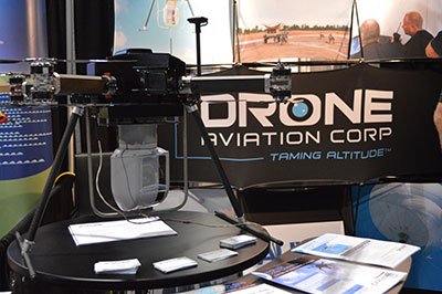
CNN will use Drone Aviation’s tethered drones to gather footage in in urban areas from never-seen-before angles and heights. The company’s WATT-200 was unveiled at the AUVSI this week.
Federal Aviation Administration (FAA) Administrator Michael Huerta announced two new initiatives related to unmanned aircraft systems (UAS) today at the Association for Unmanned Vehicle Systems International (AUVSI) Unmanned Systems 2015 conference in Atlanta, Ga.
Administrator Huerta told the large gathering of national journalists, “The unmanned aircraft industry is changing faster than any segment in the aircraft industry. A new project to harness that energy, the Pathfinder program, is partnering with three leading U.S. companies to expand unmanned aircraft operations in the United States.”
The FAA is working with industry partners on three focus areas:
CNN (Cable News Network) will research visual line of sight (LOS) operations for newsgathering in urban areas. CNN will continue working with Georgia Tech University to improve newsgathering for all organizations.
PrecisionHawk will investigate agricultural operations for rural areas, flying outside LOS.
BNSF Railway, second-largest freight railroad network in North America, will undertake inspection of rail infrastructure, also beyond visual LOS.
Huerta said that the partners, collectively, “are trying to push the envelope, what can we accommodate, accommodate safely, and what can we learn from that. We’ll test a little, learn a little, then test some more. How do we see a staged implementation? To integrate unmanned aircraft, but to do it safely, as directed by Congress. We’re trying to push the edges of what we can allow, working with partners who have specific uses and resources that they will apply to those.”
When asked for a timeframe to reach new UAV regulations, he replied, “I can’t comment a lot on the rule itself, but it’s fair to say that in the rulemaking comment process [which closed on April 24], we received more than 4,500 comments. It’s too early to say how those comments will shape what the final rulemaking will take. Assessment will be done in the coming months, perhaps by the end of the year, but that’s an aggressive timetable. This effort will go on as long as the partners want us to go on doing it. That’s not accomplished in six months, nor should it take a million years.”
As to LOS restrictions, and beyond LOS, he replied, “The framework of the previously published rule was focused on LOS, and on the use of visual observers in addition to the operator. Now we’re taking the next step, to explore beyond LOS uses. What are reasonable applications for that, and what mitigations for safety should be put in place for that? Everyone wants to get there. It’s important to figure out how we get there safely.”
What mitigations will be put in place for beyond LOS? A vice president of BSNF Railway said that the company is “working with FAA and several vendors around command and control infrastructure. This is yet to be fully defined. The railroad is a very safe an unforgiving environment. This doesn’t replace anything we’re doing today, it’s an addition.” He defined the operating environment as ” a 300 or 400-mile capability, to fly looking for broken rail, etc., beyond the visual, on-the-ground inspections that rail crews already do. ” He anticiated the use of “sense-and-avoid technology [for the UAVs], not using chase planes but perhaps using communications capabilities from cell towers and railway infrastructure along the right of way.”
The CEO of PrecisionHawk commented similarly, “We’re not changing much of our operational flow, just extending the baseline for it. We will implement a traffic-management technology, called Lattice, leveraging to ensure safety and reliability beyond the operator’s LOS.”
Gregory Agvent, CNN’s director of News Operations, said he looked forward to “some camera shots that were previously impossible for us, that now we’re going to be able to do.” Under the terms of the Certificate of Authorization (COA), Agvent said that “We’re capable of doing it [undertaking UAV missions] without asking for (FAA) permission” for specific flights.
The three industry participants concurred that they will work with their [UAV] partners in parallel with the rules to develop a certification process, so that the FAA can determine their vehicles are uniformly safe, the same way the y do with piloted aircraft currently. Both the railroad and PrecisionHawk have one currently operating flight platform each, and are looking at others, as theirs do not fit all applications.
“These are not exclusive [agreements],” emphasized Huerta, “limited to particular platforms or applications. This is a practical research effort to apply, learn, and integrate on the broadest scale.” When asked about possible further participants in the Pathfinder project, Huerta indicated the three companies represented on the briefing platform with him: “They came to us. You can interpret that as an invitation. We’re casting a very wide net. How do we et to a broader integration and implementation? We need multiple ways to gather information.”
Agvent urged, “It’s critical for manufacturers to come to the table, to get certified by make as opposed to individual models, to get free access to the sky.”
Huerta concluded, “We are learning together, as an industry and as a regulator. How can we collectively, as an industry, learn more in order to see a much more robust integration of unmanned aircraft into our aviation industry? We’re all interested in pushing the boundaries, and sharing the information broadly across the industry.”
The surprise preview of the pending announcement drew scores of curious and concerned industry representatives and exhibitors at the massive AUVSI show, who gathered anxiously outside the press briefing room, to which they were not admitted.
“The FAA is moving ahead with safe integration of UAS into the busiest, most complex airspace in the world,” according to an FAA statement issued prior to the briefing.”Even as the agency proceeds with rulemaking for small UAS, it continues to look at new ways to foster safe UAS operations by both hobbyists and businesses.”
With Exelis RangeVue, a high-performance GIS visualization engine provides real-time updates of critical operational elements.
Exelis has signed agreements with four Federal Aviation Administration (FAA)-designated unmanned aircraft systems (UAS) test sites for airspace situational awareness and research. The research will focus on using the Exelis Symphony RangeVue sense-and-avoid tool towards safe integration of unmanned aircraft into the national airspace system.
Under the terms of the agreements, the test sites will gain valuable real-time and historical situational awareness of the range airspace via Symphony RangeVue, while Exelis gains critical product feedback through operational usage. Participating test sites are:
Pan-Pacific UAS Test Range at University of Alaska, Fairbanks
Northern Plains UAS Test Site at University of North Dakota
Northeast UAS Airspace Integration Research Alliance at Griffiss International Airport, N.Y.
Mid-Atlantic Aviation Partnership at Virginia Polytechnic Institute
“The partnerships with these test sites are win-win arrangements,” said Ed Sayadian, vice president of Civil & Aerospace Systems for Exelis. “The test sites receive air traffic control quality surveillance data, increasing safety and enabling beyond-line-of-site operations, while Exelis gains critical product feedback, which will be used to shape and validate our service offerings.”
Symphony RangeVue enables UAS operators and test range personnel to have access to both real-time and historical aircraft surveillance information via a web-hosted platform, helping to manage mission operations across multiple locations.
Symphony RangeVue can be used as command center decision support and post-event analysis tool, or in the field as a sense-and-avoid addition to UAS ground control stations. Flexible geo-fencing tools alert operators when a UAS approaches airspace boundaries or other aircraft are in the vicinity.
Additionally, Exelis is pursuing research and development opportunities with the test sites exploring detect-and-avoid algorithms; non-cooperative target tracking; command and control systems; infrastructure inspection and monitoring; big data analysis for air traffic; and integration of non-FAA surveillance sources. Exelis will leverage capabilities across multiple test sites for a wide range of operational testing and collection of safety data.
The United States will reach one million unmanned aircraft systems (UAS) flights per day within the next 20 years, given the right regulatory environment, according to new economic research from the Consumer Electronics Association.
Brian Markwalter, senior vice president, market research and standards, CEA, shared the association’s domestic UAS economic analysis at the Unmanned Systems 2015 Conference in Atlanta, Ga.
“This is a billion-dollar technology market literally just waiting to take off,” Markwalter said. “We see a dynamic market with tremendous growth potential, once we have final Federal Aviation Administration (FAA) rules to allow commercial UAS operation, combined with continued industry and FAA cooperation to achieve low-risk, beyond-line-of-sight flights.”
“With the right regulatory environment, drones will be safely integrated into our transportation system — displacing noisy trucks, reducing urban traffic, cutting our fuel consumption and carbon emissions,” said Gary Shapiro, president and CEO, CEA. “This will allow for game-changing innovations such as the quick delivery of life-saving diagnostics and medicine, improvements in crop production and efficiency, and safer work environments for those who inspect and maintain our buildings and bridges.”
According to the CEA research, the U.S. UAS market is indeed growing, but risks falling behind in the global market because of fewer or more progressive regulations in other countries. In fact, as the U.S. awaits further FAA rules regarding the commercial use of UAS, CEA’s research estimates a pent-up market demand of $150-$200 million in UAS sales for “line of sight” operations.
Only hobbyists and the do-it-yourself community now are allowed to fly UAS in the U.S., enough to fuel a robust U.S. consumer market with the potential to reach $250 million by 2018. However, if the FAA remains on track to complete its line-of-sight rules for commercial operators within three years, CEA’s research foresees another $200 million in growth. Additionally, with the continued development of “sense and avoid” technology and FAA rules that foster “beyond-line-of-sight” operations, the United States’ UAS industry could become a $1 billion market.
“The ability for beyond-line-of-sight is the true game changer—opening the door to autonomous UAS operation and unleashing a remarkable economic potential,” said Markwalter. “The United States has a long history of being a technology leader—and we’ve led the world at almost every stage of flight innovation. But we have more work to do on UAS. Realizing these economic gains will require ongoing FAA and industry cooperation, as well as a commitment to the necessary infrastructure.”
CEA market research expects 2015 to be a defining year for unmanned systems, with the category ideally positioned for steady growth. According to CEA projections, the global market for consumer UAS will approach $130 million in revenue in 2015, increasing by more than 50 percent from 2014; with unit sales of consumer UAS expected to approach 425,000, an increase of 65 percent.
“Right now, more than six billion packages are delivered every year in the U.S., weighing less than three pounds apiece on average — perfect candidates for drone delivery,” said Markwalter. “The autonomous operation of UAS for the delivery of everyday items would not only lower the cost for consumers and improve delivery times, but also be a significant driver of our tech economy.”
This year CEA debuted the Unmanned Systems Marketplace at the 2015 International CES, with 15 UAS companies — almost four times as many as last year — covering 7,600 square feet of exhibit space. At CES, Shapiro announced CEA’s support of the UAS safety campaign “Know Before You Fly,” which provides prospective UAS operators with the information and guidance they need to fly safely and responsibly.
AirMap — a free, comprehensive digital map — allows unmanned aircraft system (UAS) operators to visualize the airspace around them, including areas where they may not be permitted to fly.
AirMap removes barriers to compliance of complex airspace rules by providing the low altitude airspace information that unmanned aircraft operators need. AirMap was cofounded by aviation expert and entrepreneur Ben Marcus and Gregory McNeal, a legal scholar on drones, public policy and air rights.
AirMap integrates multiple sources of reliable data and gives UAS operators an easy-to-use, yet detailed, solution providing a single view of the restricted areas around an area of operations, its makers said. The beta version of the site is now live in the U.S. and will launch soon internationally, enabling UAS operators to immediately start benefiting from the free service. AirMap also features a feedback function that will allow beta testers to request additional features.
AirMap is a fully digital map that shows only the airspace rules that impact UAS operators. By focusing on airspace information from ground level up to 500 feet, AirMap strips away the clutter of higher altitude airspace labels found on charts that were created for manned aviation, its makers said.
When using AirMap, an operator can customize their display based on the type of operation they are involved in. Operators can select layers depicting the following:
Recreational use, which will display the airspace areas around airports which are limited by community-based guidelines;
“Blanket COA” rules applicable to holders of FAA Section 333 exemptions for commercial UAS operations; and
Controlled airspace (Class B, C, D, and E) at 500 feet and below, allowing UAS operators to voluntarily comply with the airspace rules proposed in the FAA’s recent Notice of Proposed Rulemaking on the Operation and Certification of Small Unmanned Aircraft Systems.
“As UAS use continues to expand, the airspace in which operators are flying is also growing more complex. With this in mind, we’ve launched AirMap, which will serve as a resource for drone operators to immediately fly safely and in compliance with legal requirements. We want to make safe flying easy,” Marcus said.
Marcus and McNeal teamed to launch AirMap after they realized that operators needed a tool that would let them understand the complexities of restricted airspace for unmanned aircraft operations. Marcus, who co-founded aircraft brokerage firm jetAVIVA, will lead development and business growth functions. McNeal will apply his expertise and research in local regulatory environments to help AirMap reach and educate users throughout the country. In addition to his role with AirMap, McNeal is an associate professor of law and public policy at Pepperdine University and a Forbes contributor.
“As a drone operator I found it hard to know what the airspace rules were in the places where I wanted to fly. There were no accurate visuals or reliable electronic tools that could tell me and other operators where we can and cannot fly. AirMap solves this problem and helps to educate operators about this complex regulatory environment,” said McNeal. “The demand for AirMap is clear, as it is the most thorough resource for drone operators to ensure safe, legal and hassle-free flight.”
AirMap’s advisory board includes Steve Crocker, chairman of the ICANN; Stuart Banner, UCLA law professor and author of Who Owns the Sky?; Tom McInerney, former scientist at Apple; and Mike Mothner, founder and CEO of WPromote.
In February 2015, AirMap launched its first service, NoFlyZone.org, which accepts registrations from property owners who prefer UAS not overfly their land. These parcels are displayed in AirMap to help operators avoid sensitive areas, and minimize the hassles associated with disputes about where unmanned aircraft should be operating. AirMap also displays hospitals, schools and helipads and will be adding other sensitive sites in the future.
The Federal Aviation Administration (FAA) has selected Harris Corporation for an eight-year, single-award indefinite delivery/indefinite quantity (IDIQ) contract with a potential value of $238 million to design and implement a system that will disseminate real-time, comprehensive weather pictures to all aviation users across the National Airspace System.
The Common Support Services–Weather (CSS-Wx) program will help minimize flight delays and cancellations by providing additional weather data with increased accuracy to more aviation consumers, supporting real-time operational planning and decision-making.
“About 70 percent of flight delays are caused by weather,” said Carl D’Alessandro, vice president and general manager, Civil Programs, Harris Government Communications Systems. “The enterprise-wide, data-sharing design of the CSS-Wx solution will reduce these delays, saving the FAA and flying public precious time and money.”
The Harris CSS-Wx system is scalable, with Open Geospatial Consortium standards for common weather formats, and highly advanced geospatial- and temporal-based filtering methods to process meteorological data. It applies expertise the company has gained from work on mission-critical weather programs for the FAA, the National Oceanic and Atmospheric Administration and the Department of Defense.
Harris has a long history of developing and integrating system solutions for the FAA in support of the National Airspace System (NAS). The company is the prime contractor for the FAA Telecommunications Infrastructure (FTI) program, which provides critical voice, data and video communications for NAS operations and mission support functions. FTI securely connects more than 4,500 national and international FAA and DOD facilities, manages over 26,000 services, and supports more than 50,000 users. Other FAA programs developed by Harris include:
The Weather and Radar Processor, which provides weather processing dissemination and display capabilities to air traffic controllers in the en-route air traffic control environment;
Datacomm, which provides air-to-ground digital data link networks to connect FAA air traffic control sites and data communications-equipped aircraft;
The NAS Voice System, which provides a secure, IP-based voice network for critical communications between air traffic controllers, pilots and ground personnel nationwide;
The Operational and Supportability Implementation System, which serves the General Aviation community in Alaska by providing weather briefing and flight planning services; and
The National Air Space Enterprise Messaging Service, which will provide the FAA with the network-centric, collaborative information-sharing capabilities afforded by System Wide Information Management.
U.S. Transportation Secretary Anthony Foxx today announced a significant NextGen milestone with the completion of En Route Automation Modernization (ERAM), a highly advanced computer system used by air traffic controllers to safely manage high-altitude traffic.
ERAM was designed to be the operating platform for NextGen technologies, including the Automatic Dependent Surveillance-Broadcast (ADS-B) system. ADS-B transmits information about altitude, airspeed and location derived through GPS from an equipped aircraft to ground stations and to other equipped aircraft in the vicinity. Air traffic controllers use the information to “see” participating aircraft in real time with the goal of improving traffic management.
“Looking at the future of air travel, we know that there will be more planes in our skies and more people in our airports, and in order to meet this challenge we must integrate cutting-edge technology into our aviation system,” said Secretary Foxx. “ERAM is a major step forward in our relentless efforts to develop and implement NextGen. With this new technology, passengers will be able to get to their destinations, faster, safer, and have a smoother ride — all while burning less fuel to get there.”
ERAM is the backbone of operations at 20 of the Federal Aviation Administration’s (FAA’s) en route air traffic control centers. The system, a crucial foundation for NextGen, drives display screens used by air traffic controllers to safely manage and separate aircraft.
“ERAM gives us a big boost in technological horsepower over the system it replaces,” said FAA Administrator Michael Huerta. “This computer system enables each controller to handle more aircraft over a larger area, resulting in increased safety, capacity, and efficiency.”
The first ERAM system went online at Salt Lake City Center in March 2012. The final installation was completed last month at New York Center.
ERAM uses nearly two million lines of computer code to process critical data for controllers, including aircraft identity, altitude, speed, and flight path. The system almost doubles the number of flights that can be tracked and displayed to controllers.
Other NextGen technologies include:
Automatic Dependent Surveillance-Broadcast (ADS-B): The FAA is moving steadily toward replacing the old system of ground-based radars to track aircraft with one that relies on satellite-based technologies, including GPS. ERAM already receives information from aircraft equipped with ADS-B and displays that data on controllers’ screens. This technology has made it possible for controllers to provide radar-like separation to aircraft that previously operated in areas where no radar is available, such as the Gulf of Mexico and large parts of Alaska. ADS-B will replace radar as the primary means of tracking aircraft by 2020.
Performance Based Navigation (PBN): Controllers are already using ERAM to make use of Performance Based Navigation (PBN) procedures that enable controllers and flight crews to know exactly when to reduce the thrust on aircraft, allowing them to descend from cruising altitude to the runway with the engines set at idle power, saving on flying time and fuel consumption.
Data Comm: To reduce congestion on radio frequencies, the FAA and the aviation industry continue to develop Data Comm, which will allow controllers and pilots to communicate by direct digital link rather than voice, similar to text messaging. ERAM is already equipped to handle this technology.
Secretary Foxx and Administrator Huerta attributed the success of the development and installation of ERAM to the collaboration between FAA management and labor, including the National Air Traffic Controllers Association (NATCA) and the Professional Aviation Safety Specialists (PASS). This collaborative process is now a blueprint that will be applied to the rollout of future technologies.
Great view of the Pentagon while departing from the U.S. Hydro conference held in Washington, D.C.
I’ve attended five conferences in the past couple of months; Esri Water Conference (first one!), Esri Partner Conference, US Hydro 2015, APSG (Association of Petroleum Surveying & Geomatics) and the Esri Petroleum User Group (PUG) conference. It may look Esri-heavy, but the fact is that Esri is doing a really good job of organizing vertical market GIS conferences, and people are showing up. Even with crude oil prices in the cellar (relatively speaking), 1,200 people still showed up at the PUG.
There were a lot of good presentations at these conferences, and I’ll post links to some of them below. Not surprisingly, drones are a major topic of discussion at most GIS conferences. There was even a drone demo (I missed) at the Esri Partner conference showing Esri’s workflow in working with drone-collected data.
If you don’t follow me on Twitter, you might consider it. Twitter is easy and free. When I’m at a conference, I send tweets (most with a photo) in near real-time when I see something of interest. For example, I tweeted when Jack Dangermond showed up at the Esri PUG (he usually doesn’t, but did this year because it was the 25th annual conference) and had something interesting to say (read below). You can sign up for Twitter here, and then choose to follow me at https://twitter.com/GPSGIS_Eric. I get that you may be hesitant to invest any time in this, but it looks like Twitter is becoming the standard for near real-time news (as opposed to other social media such as Facebook or LinkedIn.)
Of all the new technology I’ve heard about over the past few months at these conferences, two subjects continue to excite me.
Drone Mapping. Of course, one of them is drone technology for mapping. It seems like I’ve beat this horse to death over the past few months, but it continues to get juicier and juicier. Technology development in this industry is moving really fast. It seems like new drones are being announced as frequently as new smartphones, maybe more so.
Other ancillary technologies are being developed to support commercial drone operations. For example, in my hometown (Portland, Ore.), a company called Skyward just raised $4+ million in venture capital funding to provide “professional services for UAV operations.” Essentially, the company’s software helps drone operators stay within FAA regulatory compliance.
Last year, the Oregon Unmanned Systems Business Enterprise was formed “with a two-year $882,000 state grant from the Oregon Business Development Department and the Oregon Innovation Council and will be working to match the government money with private investment and other grants.” The organization will award grants up to $75,000. The point is, the money is flowing and it’s a wide-open market.
The drone market is so wide open, in fact, that most drone companies are just buying common airframes and associated parts, putting their brand name on them, and selling them. Perhaps oversimplified, but the point is there’s not much “special sauce” (technology) being added. The manufacturers that aren’t innovating and adding valuable “special sauce” will eventually disappear. Essentially, following are the parts needed for a fixed-wing drone for mapping:
Aircraft components:
Airframe (off the shelf)
Motor (off the shelf)
Servos (off the shelf)
Propeller (off the shelf)
Radio (off the shelf)
GPS (off the shelf)
Autopilot (off the shelf)
Batteries (off the shelf)
Camera trigger (off the shelf)
Camera (off the shelf)
Ground compoments:
900-MHz controller (off the shelf)
Battery chargers (off the shelf)
Mission planning software (off the shelf)
Propeller balancer (off the shelf)
As you can see, all of these components are available off the shelf. You can order each component (maybe all of them from Amazon!), have them shipped to you, and assemble your own UAS for mapping. That said, someone who has gone through the process of building, flying and producing a valuable deliverable that you can make decisions from can add value. But, as competition increases, there’s no doubt that the companies that don’t offer much added value will not be able to operate a sustainable business.
Finally, the U.S. Federal Aviation Administration (FAA) is being surprisingly nimble, approving “333 Exemption” requests at record pace and moving towards using a “summary grant” process to issue bulk approvals of 333 Exemption requests for commercial operations.
UAS presentation from Texas A&M University, one of six FAA-designated UAS test sites.
You may want to take a look at some of the other presentations at the APSG meeting. They were very good. Here’s a quick summary of each by Jon Stigant, long-time member of APSG:
This was a primer in LiDAR technology and methodology — while most of the paper is well understood in the survey community, it is and excellent overview. A reminder for some and a way to fill in the gaps for those not so close to this technology.
Integration of UAVs into O&G Operations — Stacey Lyle, BP (presentation forthcoming)
Stacey provided a valuable summary of the direction in which the FAA is going to regulate the emerging UAV technology. A “must read” for any company that intends to either provide or use this technology. As with most government regulation there is a lot of detail, the devil is in them. Stacey recommended that the APSG engage by developing some standards for the oil and gas industry.
Ron Hughes theme is massive data and managing it — also something of a common theme for all the talks. He focused on automating data processing and recommended a concept of doing this in an automated way with 80 percent of the data. This requires careful procedural development in collaboration with a given client’s business workflows. He gave an example of a large utility company, and how the development of an enterprise metadata server had functional impact for individual business units, but also had the knock on impact of improving inter-functional/inter-community collaboration within the enterprise.
Mike provided input on Geiger mode LiDAR, differentiating Harris’ approach from the more regular LiDAR methodology. The major difference is in data density, data frequency, volume and speed used from higher flying aircraft covering a larger area faster. Providing 10-cm accuracy and expecting 7-cm acuracy development using a/c at 25,000-ft height. Focus on fast processing of immense data volumes (pedabytes) – 24-hour delivery using Harris proprietary processing. Achieve higher density at lower cost.
Mark introduced developments in GIS associated with Common Operating Picture (COP), focusing on the combining of video and data in GIS system. DPFOS mnemonic: Data Management, Planning & Analysis, Field Mobility, Operational Awareness, Stakeholder Engagement. A new SIMOPS (SIMultaneous OperationS). The key is a single source of approved data. Examples of data required in COP from specific disciplines are provided — ROVs, shore clean-up, life of field data, asset and material tracking, live/recorded video, RT data and weather integration, “in the field’” vessel implementation.
GIS, Geospatial, Geomatics…Organizational Capability Evolution — Brian Boulmay, BP (presentation forthcoming)
Rethinking Geospatial Data Management at a major operator. One Map program — not physical, one-way provision. Focus on users vs. geospatial specialists. Users business driven, specialists IT and S driven. Geospatial data integrity and analytics – people, processes and technology. ID goals — massive deployment worldwide — has to be automated. Federated system — regions only have to deal with their own regional data, not be overwhelmed by whole enterprise on their doorstep. IT has the role of providing/maintaining a worldwide solution.
Update on Spring 2014 APSG meeting — All major networks launching satellites. Very soon will have 30 live in-view satellites (U.S., Russia, Europe and China). RTK coverage in China is the best due to BeiDou, supplemented by both Indian and Japanese systems SBAS. $100 RTK on cell phone giving centimeter accuracy eventually, and changing the commercial dynamic!
Set up for managing and analyzing LiDAR data in Global Mapper. Workflows: terrain modeling, visibility, biomass (change monitoring); asset: inspect and maintain pipelines, as-built modeling, simulation. High-accuracy at relatively low cost, outpacing regulatory management. Much public data available — earthexplorer.usgs.gov. xyz values — minimum height threshold, dense RGB point cloud (almost photographic).
Automated dashboard approach, reducing pilot distraction risk, speeding up RT transfer and operational activity reporting.
Esri Conferences
Here are a couple of neat things from the Esri conferences.
First, Jack Dangermond was his usual visionary self at the Esri PUG conference, making his appearance for the 25th annual PUG. He is a master at communicating his GIS vision.
The Evolution of GIS.
In speaking about the evolution of GIS, Mr. Dangermond spoke about the far-reaching impact of email and stated that eventually web-based GIS will be deployed organization-wide, just like email. I agree with this vision. I believe the only question is timing. Is it two years from now? Five years from now? 10 years?
Onto the less visionary and more tactical tidbits…
Of particular interest to me is high-precision GNSS in the Esri environment. A lot of people I talk to are screaming for this. What does high-precision GNSS in the Esri environment mean?
support for high-precision metadata in ArcGIS Collector (ArcPad already supports this).
support for high-precision horizontal (eventually vertical) datum transformations in ArcGIS Collector.
This is important because Esri is supporting ArcGIS Collector across all mobile platforms (Android, iOS and eventually Windows), and people want to use their smartphones and tablets. ArcPad will never run on iOS or Android, so Collector is the GIS collection tool of choice, at least for the Esri environment. It needs to support high-precision GNSS, and by the looks of the following slide, it will. It’s just a matter of timing…
ArcGIS Collector to support high-precision GNSS.
The other potentially neat product Esri announced was Navigator for ArcGIS. Imagine trying to guide a work crew to a buried valve across town (or in the next neighborhood). Displaying a system or region-wide map of valves would not be an efficient way of driving your way across town to find the valve. However, giving a crew turn-by-turn street directions to the street-level, then displaying the valves on that street section, might be a very efficient way of finding the valve.
 As hundreds of thousands of tourists flock to the Washington, D.C., area for their summer vacations and residents join them on city streets and at public gatherings, the Federal Aviation Administration has a clear message for everyone: Leave Your Drone at Home.