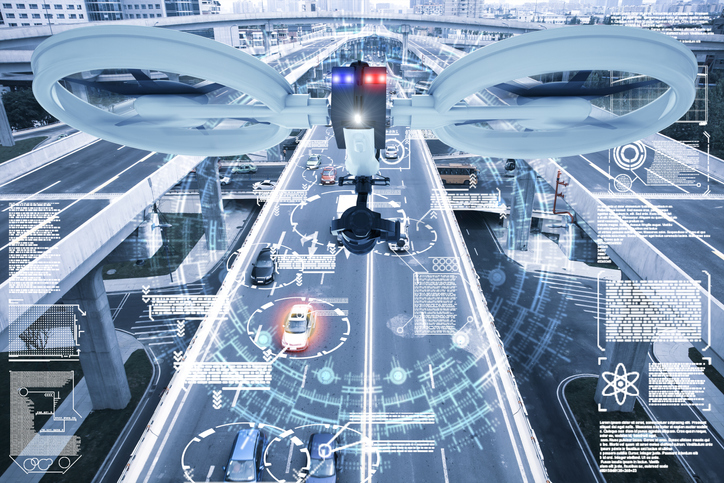
The U.S. Federal Aviation Administration (FAA) has made it easier for drone pilots to quickly and safely access controlled airspace by adding 133 air traffic facilities to the Low Altitude Authorization and Notification Capability (LAANC) system. The expansion is based on feedback from the drone community.
LAANC is an automated application and approval system for drone pilots requesting to fly below 400 feet in controlled airspace.
As the FAA continues to modernize the national airspace to accommodate more users, the agency made LAANC accessible for 726 airports and 537 facilities, covering 81% of eligible airspace.
LAANC is a collaboration between the FAA and the unmanned aircraft systems (UAS) industry which directly supports the safe integration of drones into the nation’s airspace. The service is accessible to all pilots who operate under the FAA’s small drone rule.
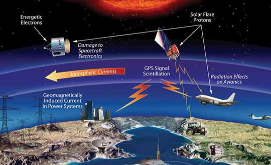
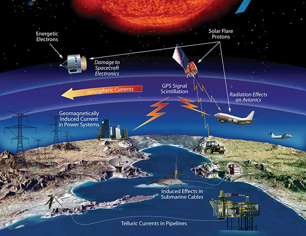
The effects of space weather on critical Earth systems. (Image: NASA)
The United States Congress has passed bipartisan legislation to address how the government deals with threats posed by emissions from the Sun to critical infrastructure such as GPS.
The Promoting Research and Observations of Space Weather to Improve the Forecasting of Tomorrow (PROSWIFT) Act S.881 now awaits signature by the president.
The bill sets forth provisions to improve the ability of the United States to forecast space weather events and mitigate its effects.
It provides statutory authority for the National Science and Technology Council’s Space Weather Operations, Research, and Mitigation Working Group, which coordinates executive branch efforts to understand, prepare, coordinate, and plan for space weather.
The bill directs the Office of Science and Technology Policy, National Oceanic and Atmospheric Administration (NOAA), National Science Foundation, Air Force, Navy, National Aeronautics and Space Administration (NASA), National Security Council, and Federal Aviation Administration (FAA) to carry out specified space weather activities.
The legislation
assigns roles and responsibilities to agencies involved in space weather research and forecasting
ensures agency coordination to better predict severe space weather events and mitigate impacts
calls for coordination between the government and the non-governmental space weather community including academia, the commercial sector and international partners.
Senators Gary Peters (D-MI) and Cory Gardner (R-CO) introduced the first version of the bill in 2016 and a successor passed the Senate in 2017. Reps. Ed Perlmutter (D-CO) and Mo Brooks (R-AL) shepherded it through the House, which passed it Sept. 16.
A new offshore service opportunity for an already proven mini-helicopter UAV, a possible alternative to flying cars, and bulking up UAVs to carry cargo – just a few of this month’s new developments in unmanned aircraft.
Oil Services UAV?
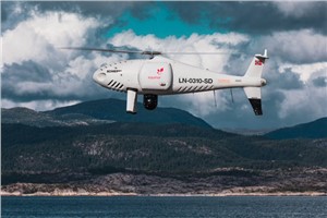
S-100 Camcopter. (Photo: Schiebel)
If you’ve ever gotten close to the Schiebel Camcopter S-100, such as at a trade show, or if you’ve worked with one, you’ve probably noticed that it’s a rugged, weather-hardened vertical take-off UAV.
It would seem that both military and maritime operations would be natural applications — so it’s not surprising that the United Arab Emirates (UAE) Army and German Navy have both bought S-100s.
The U.S. Air Force Research Laboratory (AFRL) also investigated use of the S-100 for detection of improvised explosive devices (IED).
The S-100 is a vertical take-off and landing, unmanned mini-helicopter with a top speed of around 138 mph, a range of just over 100 miles, with two payload bays, an electronics bay, and the ability to carry underslung loads — the all-up payload is 110 pounds. Sensors include an electro-optical/infrared (EO/IR) camera, an electronic support measures (ESM) system for detection and identification of electronic signatures, and synthetic-aperture radar (SAR).
So it’s no surprise that a recent trial demonstrated the S-100’s long-range, high-speed capabilities to deliver parts to a Norwegian offshore oil rig.
Nordic Unmanned and Schiebel flew a demonstration S-100 for rapid delivery of a 3D-printed replacement part from Mongstad out 55 miles to the gas production platform Troll A in the North Sea. This is said to be the first full-scale offshore UAV delivery from shore to an active oil and gas installation.
The demonstration simulated an urgent requirement for a nozzle holder for injecting diesel fuel into the platform’s lifeboat engine. Maintaining safety regulations and production flow from these offshore platforms is essential, but both ship and helicopter emergency trips out to platforms can be risky and downright dangerous in bad North Sea stormy weather — so the UAV option may save lives, time and cost.
Before flying back to base on the mainland, the S-100 also demonstrated its ability to closely inspect the operational platform, and even carried out a simulated search and rescue, locating a dummy in the water and providing live video and location data from its L3 Harris EO/IR camera and an Automatic Identification System (AIS).
Do we really need flying cars?
Where are we with people-carrying drone taxis and cars? To get them in the air for demonstration flights is tricky — there are a lot of i’s to dot and T’s to cross before agencies like the U.S. Federal Aviation Administration (FAA) allow them to fly. There are also plenty of restrictions on where they can fly — certainly not over populated areas. It will undoubtedly happen eventually, but time is money, and regulations will likely outlast the financial supply for most start-ups.
Because of this, one outfit with significant credentials has taken another tack — automating aircraft that have already earned their certified wings.
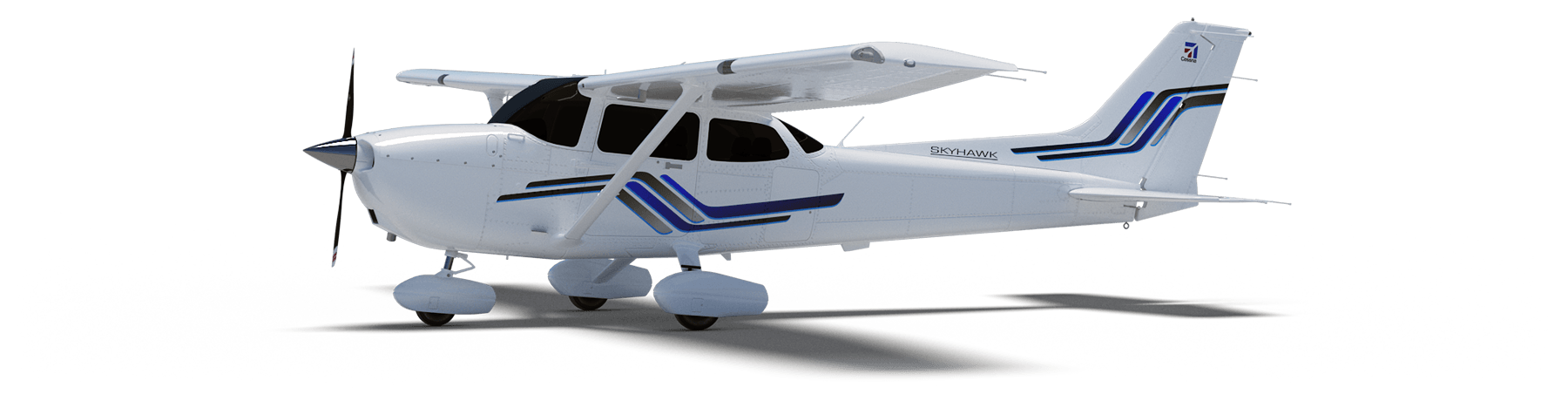
The original Cessna 172 Skyhawk test flights and certifications successfully culminated in June 1955. The Cessna 208 Caravan gained FAA approval in October 1984. Both General Aviation aircraft have flown since then with established safety and reliability records. The FAA knows what makes a safe airframe, power plant and aircraft flight controls — what’s needed to qualify a remotely piloted, automated flight control system is surely a lot less than the complete aircraft and its existing systems.
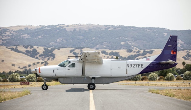
Ex-SpaceX software systems director Robert Rose decided that getting his autoflight system past FAA scrutiny would actually be an easier job. He started Reliable Robotics to get drone aircraft flying sooner.
The company has now developed an autonomous platform that can be retrofitted into virtually any fixed-wing aircraft. The system comprises avionics, flight control software, a mechanical hook-up, and a communications system which enables remote command and control, along with a reversionary backup system.
The autonomous system was integrated into a four-passenger Cessna 172 Skyhawk, and was used in an automated, unmanned gate-to-gate demonstration flight. The system underwent a full system safety analysis and test and the unmanned test flight included automatic taxiing, takeoff and landing.
The Skyhawk was flown without a pilot on board over a populated area, which was an essential part of qualifying the Reliable Robotics platform for safe civil use on an already certified passenger aircraft.
For the next test flight of a larger 14-passenger Cessna 208 Caravan, the integrated system again demonstrated full automatic remote landing of the aircraft. Reliable Robotics hopes that continuing certification efforts with the FAA will soon enable them to sell their automation system for certified unmanned passenger aircraft operations.
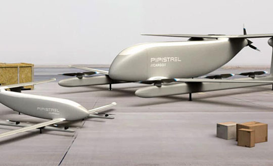
Cargo UAV
The majority of unmanned aircraft have been small. There’s even a category called small unmanned aircraft systems (sUAS) — so hanging a pizza on one for delivery by suppertime is about the most cargo you might imagine these things could carry.
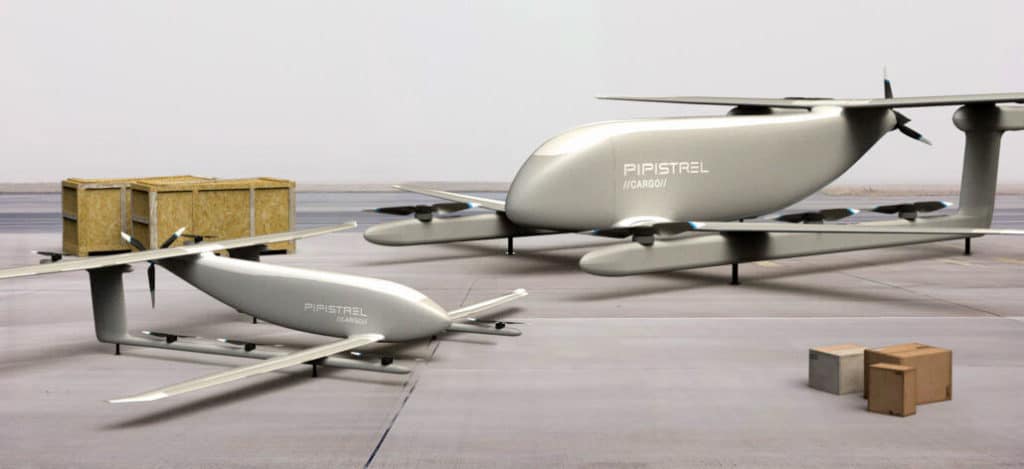
V20 and V300 cargo UAVs. (Artist’s concept: Pipistrel)
One way to overcome this limitation — as we just saw — is to hook up a sophisticated auto-flight system to a passenger aircraft. Another way could be to build a large cargo-carrying UAV — like the Pipistrel (Slovinia) Nuuva V300, which is claimed to be able to carry up to 1000-pounds of cargo over impressive distances.
The vehicle has eight identical electric motors for vertical take-off and landing, and a gas engine powers a pusher propeller for cruise. The vertical lift electric motor has apparently been certified for airborne use by the European Aviation Safety Agency (EASA).
If the V300 cargo is reduced to 110lb, it looks feasible for it to fly over 1500 miles at up to 8,000ft. Pipistrel claims this operational cargo envelope to be 10 times more efficient than for an equivalent helicopter. Pipistrel has also launched a smaller V20 cargo version with the same offset wing set up and smaller electric lift and cruise propulsion — aimed at last-mile deliveries.
Seems the V20 is available fairly soon, but the V300 still has work to do — presumably certification effort – and won’t be available till 2023.
Until next time
So potential oil-platform service deliveries for the S-100 Camcopter, turning already certified aircraft into passenger carrying unmanned vehicles, and UAVs coming for cargo carrying — all are new, promising and different UAV exploits. Let’s hope they all become commonplace in the coming years.
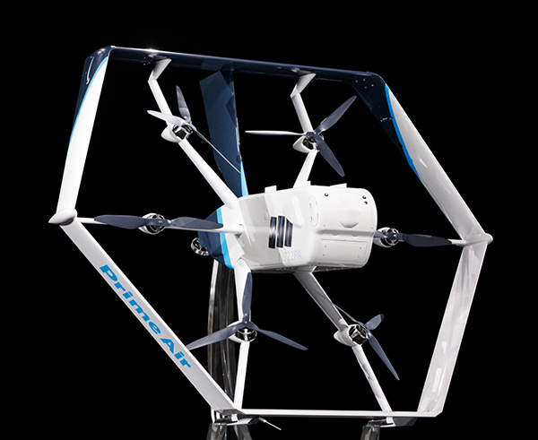
Amazon’s latest delivery drone design was unveiled in June 2019. (Photo: Amazon)
Amazon has received U.S. Federal Aviation Administration (FAA) approval to use drones to deliver packages, which Amazon says will reduce package delivery time to as little as a half-hour.
The approval will give Amazon broad privileges to “safely and efficiently deliver packages to customers,” the FAA said.
Amazon joins UPS and Alphabet-owned Wing, which previously won FAA approval for their drone delivery operations.
The approval falls under Part 135 of FAA regulations, which regulates package delivery by drone. All part 135 participants must go through a five-phase process for certification.
“The FAA is encouraging innovation through the Unmanned Aircraft Systems (UAS) Integration Pilot Program (IPP) by working with industry, state, local, and tribal governments to realize the benefits of drones, while informing future rules and regulations,” according to the FAA.
“Participants in these programs are among the first to prove their concepts, including package delivery by drone through part 135 air carrier certification. Part 135 certification is the only path for small drones to carry the property of another for compensation beyond visual line of sight.”
Amazon said it will use the FAA’s certification to begin testing customer deliveries. The company said it went through rigorous training and submitted detailed evidence that its drone delivery operations are safe, including demonstrating the technology for FAA inspectors.
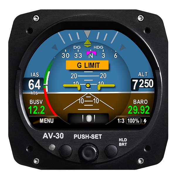
UAvionix Corporation’s aircraft AV-30-C panel display has received STC (Supplemental Type Certification) approval from the U.S. Federal Aviation Administration. The AV-30-C offers pilots an effective and affordable altitude indicator (AI) or directional gyro (DG) replacement with additional features.
AV-30-C is installable as either an AI or DG and adds a suite of in-flight information to the panel out of the box, including GPS navigational data, a probeless angle of attack indicator, baro-corrected altitude, indicated/vertical/true airspeed, non-slaved heading, bus voltage, G load and more with additional features to be announced.
AV-30-C is designed to fit into nearly any aircraft with a three and one-eighth inch round instrument slot without cutting or modifying the panel. By mounting from behind the panel, AV-30-C preserves the aircraft’s original classic look while bringing the latest that modern avionics has to offer to the panel.
The AV-30-C STC provides authorization to install in FAR Part 23 Class 1 and Class 2 aircraft (singles and twins weighing less than 6000 lbs) that are listed on the AV-30-C Approved Model List (AML), containing 635 Aircraft models including Cessna, Piper, Beechcraft, American Champion, Maule, Boeing, Swift, Mooney, Aviat and others. The full AML is available at uAvionix.com/AV-30.
AV-30-C works as a single primary instrument or by installing two units, one as an AI and another as a DG. The aircraft’s original failure-prone vacuum pump system can be removed to further benefit from a fully digital primary instrument cluster.
AV-30-C extends its functionality outside the cockpit as the companion to tailBeaconX, the latest 1090/ES ADS-B transponder with Aireon support for worldwide use and future mandated airspaces. Upon tailBeaconX TSO certification, AV-30-C can double as tailBeaconX’s control interface, allowing the pilot to set the mode and squawk easily, while maintaining AV-30’s existing feature set. tailBeaconX with AV-30-C removes the need to drill additional holes in the airframe to satisfy requirements in countries outside the U.S. and keeps installation costs to a minimum.
“uAvionix is creating avionics with fundamental engineering advantages,” said COO, Ryan Braun. “These are beautiful, no-compromise certified avionics designed to deliver an affordable total cost of ownership. The AV-30-C provides an innovative probeless angle-of-attack and non-slaved directional gyro, both designed to dramatically lower the cost of installation without compromising performance. Where other avionics seem designed to be replaced, the AV-30-C will get better with age. We’re actively developing ADS-B In, electronic flight bag, transponder, and autopilot integrations to ensure AV-30-C becomes an indispensable instrument for every panel.”
AV-30-C will support third-party autopilot systems via the APA-MINI adapter, interfacing AV-30’s heading bug with legacy autopilots. The APA-MINI autopilot adapter is expected to be released in early 2021, with more advanced autopilot integrations to follow.
The Federal Aviation Administration (FAA) plans to evaluate technologies and systems that could detect and mitigate potential safety risks posed by unmanned aircraft. The effort will be a part of the agency’s Airport Unmanned Aircraft Systems Detection and Mitigation Research Program.
The FAA Reauthorization Act of 2018 requires the agency to ensure that technologies used to detect or mitigate potential risks posed by unmanned aircraft do not interfere with safe airport operations.
The FAA plans to test and evaluate at least 10 technologies or systems. The evaluations are expected to begin later this year and will initially occur at the FAA’s William J. Hughes Technical Center, located next to the Atlantic City International Airport in New Jersey.
After the initial testing and evaluation in New Jersey, the agency expects to expand the effort to four additional U.S. airports. Those selections will be made at a later date.
According to the FAA, interested manufacturers, vendors and integrators of drone detection and/or mitigation technologies/systems will have 45 days to respond to its announcement.
In addition, the FAA expects to issue another solicitation in the coming weeks for airport operators interested in hosting the additional research and testing.
provide a better understanding of the activity, uses, users and broader beneficiaries of the National Geodetic Survey’s Aeronautical Survey Program,
help define its socio-economic benefits,
provide preliminary order of magnitude estimates of benefits of the program, and
examine influences on future needs for the program’s services.
The footprint (trade space) analysis presents data on airport improvement grants, activities of the program, airports, aviation and societal beneficiaries. Methods of estimating socio-economic benefits are considered, preliminary estimates of benefits are made and issues that will affect use of the services in the future are discussed. Additional information is included in 10 appendices.
The FAA Airport Improvement Program (AIP) provides grants, to public agencies for planning and development of the 3,249 eligible public-use airports and the 72 privately owned civil airports.
The FAA requires that geographic information system (GIS) contractors submit plans and surveys with geodetic control, runway, navigational aid, obstruction and other aeronautical data under its Airports GIS (AGIS) program. These contracted survey plans and surveys are sent to the NGS Aeronautical Survey Program (ASP) for quality assurance review.
The GIS information is used by the FAA in establishing flight rules and other requirements to assure safety.
Irv Leveson is an economist with extensive experience examining GNSS markets, applications, benefits and policies. His public studies include: “The Economic Benefits of GPS.” He recently led a National Geodetic Survey study.
The Federal Aviation Administration (FAA) has awarded $3.3 million in research, education and training grants to universities that comprise the FAA’s Air Transportation Center of Excellence (COE) for Unmanned Aircraft Systems, also known as the Alliance for System Safety of UAS through Research Excellence (ASSURE).
“These grants will help develop a greater array of innovative strategies to more effectively deploy drones during emergency response situations,” said U.S. Transportation Secretary Elaine Chao.
The FAA’s CEO program, authorized by Congress, is a long-term, cost-sharing partnership between academia, industry and government. The program enables the FAA to work with center members and affiliates to conduct research in airspace and airport planning and design, environment and aviation safety, FAA said.
Mississippi State University received the Alliance for System Safety of UAS through ASSURE Program Management grant for $1,290,410. This grant is for the ASSURE lead university to provide overall program management. This program management will include tracking of financial information for all core university project activities; reviewing and vetting of all project related documentation prior to submission to the FAA; hosting and facilitating all FAA-required meetings; and outreach to government, industry and academia, FAA said.
Six universities, including the University of Alabama–Huntsville ($1,101,000), New Mexico State University ($234,000), the University of Alaska, Fairbanks ($245,000), Mississippi State University ($130,000), North Carolina State University ($124,979) and Oregon State University ($165,000) received grants for Disaster Preparedness and Response (Phase I and II, as directed by Congress). According to FAA, this research will provide insight into the safe integration of UAS into the disaster preparedness and response areas. This research will look at how UAS can aid in disaster preparedness and response to different natural and human-made disasters. It will focus on procedures to coordinate with the Department of Interior, the Department of Homeland Security, the Federal Emergency Management Agency and other federal, local and state organizations to ensure proper coordination during those emergencies.
There are currently 1.65 million recreational and commercial drones in the active UAS fleet. That number is expected to grow to as high as 2.31 million by 2024, FAA reported. The ASSURE grants are aimed at continuing the safe and successful integration of drones into the nation’s airspace.
“Collaboration is hugely important as we work to safely integrate UAS into the aerospace system,” said FAA Administrator Steve Dickson. “These important grants fund the research which allows us to learn and implement the safety measures associated with UAS operations in the airspace.”
The COE universities received a total of $3.3 million to advance specific goals and projects. This is the second round of ASSURE grants. The grants listed above will bring the fiscal year 2020 total for this COE to $5.8 million.
The Federal Aviation Administration (FAA) and the Association for Unmanned Vehicle Systems International (AUVSI) will host the 5th annual FAA UAS Symposium virtually, rather than in-person in Baltimore. The event will take place June 16-18.
This decision was made as a result of the ongoing concerns caused by the COVID-19 pandemic, the organizers said.
The FAA and AUVSI also will be hosting a series of virtual events that will address the content already planned for this year’s program. The fist will take place in early summer and will focus on UTM and international UAS integration. The second will take place in late summer with a focus on updates to the Integration Pilot Program and public safety operations.
According to organizers, those registered for the 5th annual FAA UAS Symposium will receive a separate message in the coming weeks to confirm options for participation in the virtual events.
Those selected as speakers for the 5th annual FAA UAS Symposium will receive a separate message from AUVSI’s Industry Education Team to confirm participation, as well as any schedule changes.
The U.S. Department of Transportation’s Federal Aviation Administration (FAA) announced the eight companies that will assist the federal government in establishing requirements for future suppliers of Remote Identification (Remote ID).
Remote ID will enable unmanned aircraft systems (UAS), commonly called drones, to provide identification and location information while operating in the nation’s airspace.
The FAA selected the following companies to develop technology requirements for future Remote ID UAS Service Suppliers (USS):
“The FAA will be able to advance the safe integration of drones into our nation’s airspace from these technology companies’ knowledge and expertise on remote identification,” said U.S. Transportation Secretary Elaine L. Chao.
This initial group will support the FAA in developing technology requirements for other companies to develop applications needed for Remote ID. The applications will provide drone identification and location information to safety and security authorities while in flight.
The technology is being developed simultaneously with the proposed Remote ID rule. Application requirements will be announced when the final rule is published. The FAA will then begin accepting applications for entities to become Remote ID suppliers. The FAA will provide updates when other entities can apply to become qualified Remote ID USS on FAA.gov.
Drones are a fast-growing segment of the transportation sector with nearly 1.5 million drones and 160,000 remote pilots now registered with the FAA. The agency’s ability to develop Remote ID technology simultaneously with the rule enables the FAA to continue to build on a UAS Traffic Management (UTM) system that has demonstrated global leadership through the small UAS rule and the implementation of the Low Altitude Authorization and Notification Capability (LAANC), which automates the application and approval process for most UAS operators to obtain airspace authorizations.
Image: 4X-image iStock / Getty Images Plus / Getty Images
Nearly 4,000 waivers granted under Part 107; about 20 percent of waivers granted to organizations received by first responders
Almost four years after the Federal Aviation Administration (FAA) established rules for the commercial operation of small unmanned aircraft systems (UAS), a new report by the Association for Unmanned Vehicle Systems International (AUVSI) found that nearly 4,000 operators across all 50 states have been granted waivers to go beyond current regulations.
First responders across the country received about 20 percent of all waivers granted to organizations (398), which demonstrates growing interest and need for public safety applications enabled by UAS, including search and rescue and firefighting at night.
Effective Aug. 29, 2016, the small UAS rule, also known as Part 107, created a uniform regulatory framework for UAS. Among the rule’s requirements, UAS must fly below 400 feet above ground level (AGL), within visual line of sight and during daylight hours.
Recognizing the need for the rule to be flexible to foster innovation, the FAA created a waiver process that allows for expanded types of operations, such as nighttime or beyond line of sight operations, with the approval of the agency.
AUVSI analyzed 3,946 of these waiver documents granted by the FAA since Part 107 went into effect. While the vast majority of waivers (3,636 or 92 percent) were granted to waive the requirement for flying only during the daytime to enable nighttime operations, the FAA has also granted waivers from other sections of the regulations to permit advanced operations, including:
Flights over people (112 waivers);
Operation in certain airspace (97 waivers);
Operating multiple UAS at the same time (55 waivers);
Visual line of sight operations (to enable beyond line of sight operations) (51 waivers).
Operators in all 50 states, as well as the District of Columbia and Puerto Rico, have received waivers. California leads the way with 451 waivers granted, followed by Texas (334), Florida (272) and New York (159). About 87 percent of all waivers were granted to small businesses with fewer than 10 employees and annual revenues of less than $1 million.
“Across the country, operators have demonstrated they are eager to harness the tremendous potential of expanded UAS operations,” said Brian Wynne, president and CEO of AUVSI. “Small businesses have been able to save time and money, and first responders and public safety agencies have used UAS technology to increasingly contribute to the greater good worldwide, supporting missions from disaster relief to humanitarian aid.”
Last month, AUVSI submitted its comments on the FAA’s Notice of Proposed Rulemaking (NPRM) for Remote Identification of UAS. In the comments, AUVSI urged the FAA to proceed concurrently with rulemaking that would allow for expanded operations rather than wait for a fully implemented remote ID rule to avoid unnecessary delays. The FAA says it hopes to issue a final rule before the end of the year.
In the interim, the FAA recently announced several initiatives to improve the waiver application process in response to a review last year of the waiver framework by a task group of the Drone Advisory Committee that was chaired by Wynne.
The FAA’s plans include expediting the waiver renewal application process, particularly in instances where there hasn’t been many changes since the original application; enabling quick administrative changes to previously granted waivers; providing more responsive feedback to applications that were not approved; streamlining the applications; implementing new regulations to obviate the need for waivers; and increasing transparency and accountability to provide support for waiver applications, disapprovals, and general UAS questions.
“The waivers that have been granted so far demonstrate that operators are safely able to conduct expanded operations, such as flights over people and beyond visual line of sight,” said Wynne. “While improvements to the waiver process are needed and welcomed, we urge the FAA to move forward rapidly with rulemakings that would enable these operations widely and provide the economic and societal benefits they offer.”
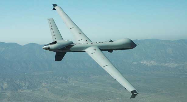
General Atomics MQ-9 Predator. (Photo: General Atomics)
There has been a lot of scene stealing by General Atomics recently with Predators flying hither and thither, new orders for the Boeing-Navy unmanned re-fueling drones and a UAV flying on Mars — this month’s unmanned aircraft summaries.
The Predator is the archetypical unmanned aircraft which most people might visualize as a “drone” as a result of numerous news reports and photos. Its what we might refer to a “Large UAV” with a 65-ft. wingspan, a 35 ft.-long fuselage and weighing in at around ~10,500 pounds fully fueled.
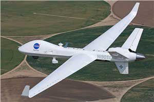
The SkyGuardian. (Photo: General Atomics)
In fact it’s bigger than a small manned aircraft, like the single engine Cessna 182 which checks in at 36ft wingspan/29ft fuselage. So its clear that something this big and without an on-board driver has to watch where its going, especially when flying within in the US National Airspace System (NAS).
So it was no small feat when General Atomics recently flew a new MQ-9 Predator on a delivery flight from its flight ops center in Palmdale, California, to the Holloman Air Force Base in New Mexico. There was significant coordination by the flight teams in both locations, and with the approval by the FAA. Delivering a new Predator by air saves the Air Force significant manpower, as normally new ones arrive in a crate and require effort to re-assemble.
It’s a sign of progress towards achieving approval to allow regular flights of such large UAVs in the NAS. Nowadays a Cessna 182 pilot can file a flight plan and then basically fly anywhere in unrestricted airspace. Hopefully one day — as a consequence of following rigorous certification verification and FAA approval – pilots of such Large UAS will be authorized to operate in a similar fashion.
General Atomics is working with the U.K. Royal Air Force (RAF) to develop and certify the all-weather, long-endurance SkyGuardian MQ-9B variant to meet NATO-standard Type-Certification requirements, which will then enable the UAV to be flown in civil airspace. The Australian Defence Force (ADF) has also selected this UAV variant for its unmanned applications in and around Australia. In late March, General Atomics flew the first production representative SkyGuardian – known to the RAF as the ‘Protector’ – out of its flight ops facility in El Mirage, California.
Staying with the military theme, Boeing has been working with the US Navy to develop a UAV that can land on aircraft carriers, and following a concept change by the Navy, won a contract to provide tanker UAVs. Tanker UAVs will fill up with aircraft gas on an aircraft carrier or land base, then take off and fly to rendezvous with fighter aircraft to transfer fuel and extend fighter endurance and range.
Right now tanker aircraft are usually quite large aircraft – like the Boeing KC-46A tanker which is based on the Boeing B-767 civil transport aircraft which many of you may have flown on as passengers.
The MQ-25 is still in its initial phases, with four test UAVs slated to undertake the initial flight test program. The first test vehicle has already begun exploring the UAV flight envelope and has 30 flight-test hours under its belt. The Navy has just shown confidence in the program by ordering another three aircraft, bringing the total initial build to seven vehicles.
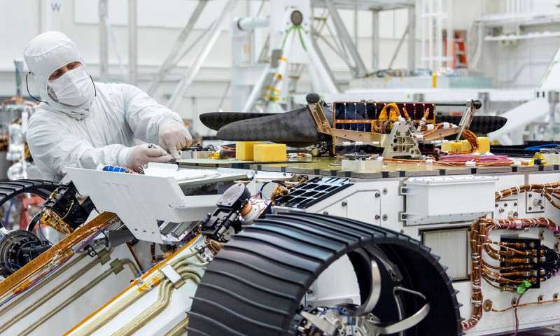
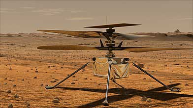
Its easy to see that UAVs are showing themselves to be extremely useful to military forces, but it might be difficult to understand how a UAV might find itself in the U.S. space program. The “Mars Helicopter” has just been mated to the underside of the next Mars Rover — now called “Perseverance” — both are slated to leave on their eight month journey to Mars in July this year.
Mars UAV being mater with Perseverance. (Photo: NASA)
With two ~4ft rotors which spin in opposite directions, the UAV will have to wait patiently for up to 90 Martian Days after Perseverance touches down in February 2021 until it gets a chance to prove that it can fly in the thin Mars atmosphere — chamber tests here on Earth in simulated Mars air have already shown that flight should be feasible.
Built to withstand high g launch and vibration forces and those of the Mars landing, the UAV carries a high resolution camera which is used for navigation, landing and survey of Mars’ surface. Its also designed to withstand the extreme temperatures and high radiation environment on the surface of Mars. The UAV is equipped with a dual-processor flight controller linked to sensors which include a gyroscope, an altimeter, visual odometer, hazard detectors and a ‘visual inertial nav system’ developed by JPL. Although the Mars Helicopter operates autonomously, it communicates with and receives control inputs from the lander, so controllers on Earth load up the flight plan ahead of time into the lander, and then wait for the helicopter UAV to execute the commands. Don’t expect vast coverage of huge panoramas of Mars – its flights are each intended to be more of an extensive hop lasting around 90 seconds at 10-15 ft above the terrain.
Mars Helicopter on simulated Mars surface. (Photo: NASA)
With a body no larger than a softball and weighing less than 4 pounds, the Mars Helicopter is an experiment to see if its possible to fly in the extremely thin Martian atmosphere. With less than 1% the density of our sea-level atmosphere, its necessary to spin the rotors at 2,800 rpm, ten times faster than on Earth. The UAV collects power from its own small solar panel and needs several days to recharge after each flight — of which five are planned. The main objective if flight is possible is to pre-survey interesting potential routes for the lander.
So preparations for large UAVs to regularly fly in civilian airspace, a new approach for Navy refueling systems, and a helicopter UAV destined to fly on Mars next year — completely different unmanned applications, all making progress.