Tag: FCC

  • PNT Board opposes Ligado ‘lite’ proposal, DARPA seeks photonics

    PNT Board opposes Ligado ‘lite’ proposal, DARPA seeks photonics

    On Aug. 10, the National Space-Based Positioning, Navigation, and Timing (PNT) Advisory Board, the government’s GPS expert board, sent a letter to the National Executive Committee for Space-Based PNT (a multi-agency body that steers GPS policy) that concluded, “We strongly recommend your opposition to the Ligado proposal.”

    The letter sprang from a unanimous vote five days earlier to oppose allowing Ligado Networks to use spectrum neighboring the GPS band for terrestrial communications.

    Ligado possesses licenses to broadcast on two satellite bands located adjacent to the GPS frequencies. The company has been seeking permission from the Federal Communications Commission (FCC) to repurpose these licenses from satellite-based use to ground-based use from powerful tower transmitters.

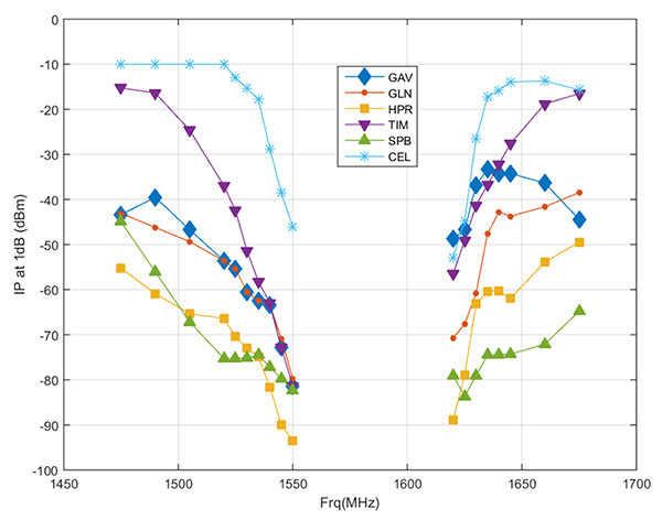
    Ligado said in May it would lower the power in its proposal for the 1526–1536 MHz band to 9.98 dBW to avoid interference with certified aviation receivers. However, the PNT Advisory Board reiterated its opposition, saying that even if the transmissions’ power was lowered to just under 10 watts, it “will create totally unacceptable interference for a great number of GPS users in the United States.”

    From the Letter: “This risk is far too great, and far too many questions remain, for Ligado’s proposal to be approved. While there are many broadband alternatives (Ligado would be a very small percentage of this national asset), there is only one GPS. Any impairment to current and future uses is clearly contrary to the national interest. Therefore, implementation of their recently proposed ~10-watt operating scheme will create totally unacceptable interference for a great number of GPS users in the United States. In fact, despite power limits in their current amended application, it is probable they could still be allowed to increase this power over time. This would be even more destructive to GPS users.

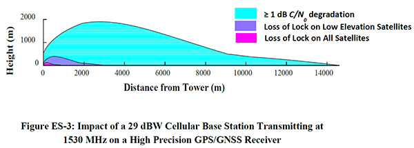
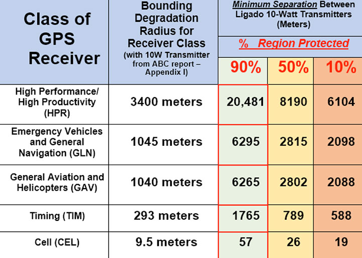
    “We believe avoiding degradation over at least 90 percent of the region near Ligado transmitters is the absolute minimum protection for GPS receivers in each class. This would be a hypothetical 90 percent Protection Evaluation. This is not an endorsement of this level since, of course, all users would prefer 100 percent protection. The Department of Transportation (DOT) Adjacent Band Compatibility (ABC) study is the only validated test to verify degradation at various received power levels.

    “Those results inform that to insure degradation not exceed 10 percent of the Region (90 percent Protection) for High Performance receivers, either:

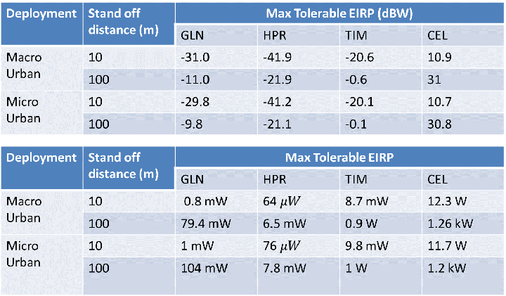
    Ligado maximum power can be no more than .0036 watts at the 400-meter spacing they had earlier planned. Tolerable power would be 3/10ths of 1 percent of their proposed ~10 watts. Or

    the closest spacing of Ligado transmitters is 20,000 meters (over 12 miles) for their proposed ~10 watt power level (see Figure 1).”

    Figure 1. The PNTAB strongly believes that 90% is the minimum Area Protection Criterion (maximum 10 % degradation). (Chart: PNT Advisory Board)
    Figure 1. The PNTAB strongly believes that 90 percent is the minimum Area Protection Criterion (maximum 10 percent degradation). (Chart: PNT Advisory Board)

    DARPA wants photonic integrated circuits

    High-energy photons emission (abstract illustration). (GiroScience/Shutterstock.com)
    High-energy photons emission (abstract illustration). (Photo: GiroScience/Shutterstock.com)

    The U.S. Defense Advanced Research Projects Agency (DARPA) Microsystems Technology Office is soliciting research proposals for the development of a new class of atom-based systems using integrated photonics and trapped atoms to enable high-performance, robust, portable clocks and gyroscopes.

    The military researchers are asking industry to develop relatively simple portable photonic integrated circuits (PICs) for high-performance position, navigation and timing (PNT) devices as an alternative to GPS for when satnav signals are not available.

    A PIC or integrated optical circuit, similar to an electronic integrated circuit, integrates multiple photonic (having to do with light) functions, providing capabilities for information signals imposed on optical wavelengths, typically in the visible spectrum or near-infrared, 850–1650 nanometers.

    A-PhI Program

    The Atomic-Photonic Integration (A-PhI) program seeks to develop trapped-atom based, high-performance PNT devices, reducing the complexity of these atomic systems by using PICs. According to the DARPA document, the PICs will replace the optical assembly behind devices such as sensitive and accurate angle sensors and clocks, while still enabling the necessary trapping, cooling, manipulation and interrogation of atoms.

    A-PhI aims to demonstrate that compact PICs can replace the optical bench of conventional free-space optics for high-performance trapped-atom gyroscopes and trapped-atom clocks without degrading the performance of the underlying physics package.

    Physics

    Atomic systems using trapped atoms have the potential to be made portable while maintaining their accuracy due to the atomic trap’s small size and the inherent isolation a trap offers an atomic system from the environment, especially from acceleration.

    Currently, these systems are bulky, heavy, and not notably portable, because of the complexity of the optical systems used to create the trap.
    In the past, efforts to miniaturize the hundreds to thousands of optical components in such benchtop systems have relied on removing optical elements, miniaturizing the remaining elements, and tightly integrating them in a small package.

    The products deliver degraded performance with the need to maintain very tight optical alignment, causing both poor environmental robustness and poor tolerance to design errors. Effective miniaturized atomic systems cannot be achieved at a reasonable cost with this approach.

    Recent developments in PIC research suggest that on-chip optical frequency combs based on microresonators, optical frequency synthesis, novel on-/off-chip coupling, wavelength demultiplexers, and on-chip phased arrays for dynamic manipulation of light fields can replace optical systems with readily manufacturable, low-cost chips without the alignment sensitivity of conventional free-space optics.

    Gyroscopes

    A-PhI also seeks to develop proof-of-concept trapped atom gyroscopes, a matter-wave analog of the interferometric fiberoptic gyroscope. Such a miniaturization effort could generate an order of magnitude improvement in angular sensitivity and dynamic range over current free-space products.

    A-PhI hopes to develop portable, high-performance, navigation and timing systems: the miniaturization of the optics of atomic systems without a decrease in performance. Subsequent work, the RFP asserts, will be required to incorporate the necessary compact and robust lasers and electronics to achieve a fully functioning, high-performance, portable PNT system.

  • Taking a look at the rest of the Ligado story

    Taking a look at the rest of the Ligado story

    Alan Cameron
    Editor-in-Chief and Publisher, GPS World

    “All the News that Fits” can sometimes be a hard motto to live up to, and it has turned out so this month. I want to get more material into our pages for your perusal, and it just could not be crammed into the System of System pages in this issue. Therefore, I cede my “Out in Front” editorial to the 27 gentlepeople, executives across the commercial, scientific and government agency spectrum, who wrote to U.S. Federal Communications Commission (FCC) chair Ajit Pai on July 18.

    The core quotes from the letter appear here. However, there’s more meat on the bones and I want to present it here.

    “The undersigned organizations, representing entities that provide and rely upon critical GPS, satellite communications (“SATCOM”) services, and essential weather and other environmental data, write to inform you that the threat of harmful interference from Ligado’s proposed ancillary terrestrial component (“ATC”) service continues to pose a significant risk of harmful interference despite Ligado’s May 31, 2018, amendments to its license modification applications in the above-referenced file numbers. The record, augmented by recent government reports, makes clear that the interference will be particularly impactful to the countless government and commercial entities that rely on GPS and SATCOM services for aviation safety and other critical services and the many groups that receive and depend upon real-time weather and related environmental information from National Oceanic and Atmospheric Administration (“NOAA”) satellites…

    “We recognize the importance of ensuring that there is sufficient spectrum for mobile broadband, and the Commission has recently taken many steps to address that challenge. However, at a time in which the Administration has placed so much emphasis on the critical importance of space-based communications — through the revival of the National Space Council and other policy initiatives — the FCC should not undermine the nation’s critical space leadership.2 Granting Ligado’s request would harm the nation’s satellite industry and the broad sectors of the country that benefit from American space leadership every day in at least three ways. First, it would threaten the reliability of critical position, navigation and timing (“PNT”) services, including GPS and also an emerging satellite time and location (“STL”) capability augmenting GPS.

    “Second, it would undermine the investment-backed expectations of those who operate commercial satellite systems by fundamentally altering the interference environment decades after licensing.

    “And third, it would convert 40 MHz of increasingly rare satellite spectrum away from satellite use, rewarding a company for underutilizing its satellite spectrum rather than investing in new satellite technologies.”

    In addition to several organizations, the letter is signed by the Aircraft Owners and Pilots Association, the American Geophysical Union, American Weather and Climate Industry Association and the National Emergency Number Association.

  • Trying to accommodate GPS interference? Enough already

    Eight years on, and the money generated by a hedge fund still seeks to destabilize the Global Positioning System and the billions of people who benefit from it, whether they create it, administer it, sell it or use it.

    That accounts for just about everybody touched by telecommunications and the industrial network, including the brave individuals serving in the military.

    For rewards to the few, the U.S. government is lobbied to levy hardship on the many. In the service of that lobbying, the truth is manipulated to suit the ends. Sound familiar?

    See this article for facts and findings of years of detailed study of this matter, recounted in the recently released Department of Transportation’s Adjacent Band Compatibility (ABC) Assessment Final Report. That it appears almost a year after all the research and nearly all the analysis was completed suggests that powerful forces are at work, perhaps warring with each other, within the government. Let us hope that the guys and gals with the good hats on can prevail.

    The matter now rests with the Federal Communications Commission, an appointed panel not subject to the electorate nor to Congress, whose decisions sometimes carry a scent of influence from hidden quarters. Note particularly the recent ruling against net neutrality, which most agree runs counter to public interest and correlative with private corporate interests.

    As our news story states, the ability to use the mobile satellite services (MSS) band for terrestrial services is “limited.” The DOT ABC Assessment, using the 1-dB Interference Protection Criterion of a 1-dB drop in carrier-to-noise density ratio that’s accepted by everybody — specifically, every engineer — on Earth except Ligado Networks, demonstrates conclusively there is no chance the company could actually deploy a viable commercial terrestrial service in the MSS spectrum without disrupting or degrading vital GPS and GNSS services.

    The U.S. government and the GPS industry have both expended far too much money and time trying to accommodate a force-fit of a non-compatible use into the bands adjacent to the radionavigation satellite service band, to the benefit of one commercial company’s bottom line.

    It’s high time for this nonsense to stop. Nobody, least of all the government and the GNSS industry, owes Ligado anything.

  • The Adjacent Band Compatibility Assessment: What it means and why it matters

    The Adjacent Band Compatibility Assessment: What it means and why it matters

    The culmination of several years of test and analysis conducted by the U.S. Department of Transportation, the assessment will play a key role in the Federal Communications Commission’s upcoming decision on a proposal from Ligado Networks.

    The long-awaited Final Report for the U.S. Department of Transportation’s Adjacent Band Compatibility (ABC) Assessment was released on April 26.

    The report is the culmination of several years of test and analysis conducted by the DOT, with input and assistance from the public and federal agency stakeholders. Though not explicitly motivated by it, the assessment appears to be responsive to the Positioning, Navigation, and Timing (PNT) Executive Committee’s (EXCOM’s) Jan. 13, 2012, memorandum to the National Telecommunications and Information Administration (NTIA) that sought to develop metrics to inform commercial non-space proposals for use of frequency bands adjacent to those used by GPS, so that existing and evolving space-based PNT services “vital to economic, public safety, scientific and national security needs” were not affected by implementing such proposals.

    The assessment will likely play a key role in the Federal Communications Commission’s upcoming decision on a proposal from Ligado Networks to add an extensive complex of powerful ground transmitters to its system, broadcasting on frequencies allocated for satellites.

    Open and Transparent. Two key attributes of the ABC assessment were that it was conducted openly and transparently, with numerous public workshops announced via the Federal Register, and it was agnostic to any particular proposal for use of bands adjacent to GPS/GNSS services. The approach chosen by DOT in performing its assessment was to develop maximum tolerable effective isotropic radiated power (EIRP) levels that could be transmitted at differing frequency offsets from the GPS L1 center frequency.

    The term “adjacent” in this regard is a bit of a misnomer in that the assessment range extended to 100 MHz on either side of the GPS L1 center frequency of 1575.42 MHz. This approach was recently validated by the National PNT Systems Engineering Forum (NPEF), which found the ABC assessment was the only one of five test and analysis efforts conducted since 2011 on adjacent-band terrestrial operations that met all six of the test criteria recommended by the experts serving on the National PNT Advisory Board. The NPEF analysis is available here.

    Measurements on 80 civil GNSS and GPS receivers were performed at White Sands Missile Range (WSMR) in New Mexico. The Air Force conducted a prior week of testing on military GPS receivers at WSMR, and while the results of that testing are classified, an Air Force briefing at the November 2017 PNT Advisory Board meeting indicated the military receiver test results supported the conclusions drawn by the DOT ABC assessment. Certified aviation GPS/GNSS receivers were analyzed by RTCA Inc. and are being analyzed by the FAA in terms of determining power levels in adjacent bands that don’t exceed FAA Technical Standard Orders. However, the overall ABC assessment indicates that certified aviation receivers are not the limiting case for tolerable interference from adjacent-band services to GPS and GNSS receivers.

    Test Procedures

    Compatibility assessment for the civil receivers consisted of conducting the initial measurements at WSMR for six categories of receivers: aviation (non-certified), cellular, general location/navigation, high-precision, timing, and space-based receivers. These were evaluated to determine what DOT called Interference Tolerance Masks (ITMs) for each category of receiver and each receiver tested. The ITMs define the maximum aggregate interfering power that can be tolerated by a given GPS or GNSS receiver. The ITMs are based on the internationally accepted Interference Protection Criterion (IPC) of a 1-dB drop-in carrier-to-noise density ratio (C/NO) for the receiver, or, equivalently, an interference density-to-noise ratio (IO/NO) of –6 dB. This 1 dB IPC standard, which NTIA directed to be used in the NPEF evaluation of the original LightSquared (now Ligado) adjacent-band proposal in late 2011, is explained in great detail in a white paper the Air Force made publicly available in 2017.

    The assessment then developed, with input from the public at several workshops convened by the DOT, use cases to determine how close a receiver for a particular GPS or GNSS application might be to a base station or handset of a commercial terrestrial service in an adjacent band. Proximity distances of 10 and 100 meters were selected from these use cases, and maximum tolerable transmit EIRP levels for a given frequency offset were determined; see Figure 1. The high-precision receivers (HPRs) were the most susceptible to interference from terrestrial operations in the adjacent bands.

    Figure 1. Maximum tolerable power level for GPS/GNSS receivers at 1530 MHz. (Table: DOT)
    Figure 1. Maximum tolerable power level for GPS/GNSS receivers at 1530 MHz. (Table: DOT)

    One thing that seems clear is that, with tolerable transmit power levels in the milliwatt and microwatt range, the potential to use the bands near GPS frequencies for commercial terrestrial wireless services may be limited. Illustrating that point further, the assessment shows that, based on the assumptions in the study, HPRs can be affected at distances beyond 14 kilometers (see Figure 2), and that loss of lock for low-elevation satellites can occur at distances of up to 3 kilometers from a base station providing terrestrial services using characteristics adopted internationally in the International Telecommunication Union (ITU) study groups.

    Figure 2. Impact of a 29-dBW cellular base station transmitting at 1530 MHz on a high-precision GPS/GNSS receiver. (Chart: DOT)
    Figure 2. Impact of a 29-dBW cellular base station transmitting at 1530 MHz on a high-precision GPS/GNSS receiver. (Chart: DOT)

    Moreover, the assessment determined that the potential interference to other GNSS systems may be more problematic, noting that “the levels that protect all GNSS signals can be as much as 15 dB lower than those needed to protect L1 C/A signals from base station emissions with an average difference of 3.5 dB across all frequencies and five categories considered.”

    Galileo’s Role. Since 2013, according to a Public Notice from the FCC, the European Commission has sought a waiver of FCC rules that require licensing of receivers operating with foreign satellites so that Galileo service can be provided in the United States. The FCC has yet to act on this waiver request, which was issued in a January 2017 Public Notice, despite overwhelming public support and a positive recommendation from the Executive Branch in 2015.

    Figure 3. Bounding masks for each category corresponding to the 10 MHz LTE interference signal and L1 C/A GPS signal: general aviation, general location and navigation, high precision, timing, space-based, cellular. (Graph: DOT)
    Figure 3. Bounding masks for each category corresponding to the 10 MHz LTE interference signal and L1 C/A GPS signal: general aviation, general location and navigation, high precision, timing, space-based, cellular. (Graph: DOT)

    Conclusions

    It is well known that all receivers take in some power from signals transmitted in nearby frequency bands. Considering this fact, the ABC assessment is relatively unique in that it examines the overall spectral environment in which GPS/GNSS operations can be affected rather than just the band allocated to the Radionavigation-Satellite Service (RNSS, the broad radiocommunication service defined in the ITU and in domestic rules under which GPS and other GNSS systems operate) between 1559–1610 MHz. That the overall environment should be considered is an important aspect of any discussion of protecting GPS and other GNSS services given the U.S. National Space Policy that was signed into effect June 28, 2010, that directs the U.S. government to “take necessary measures to sustain the radiofrequency environment in which critical U.S. space systems operate.” This policy is still in effect, and it would be difficult to argue that GPS is not a critical U.S. space system.

    Recently, the reconstituted National Space Council adopted four recommendations, one of which related to spectrum used for satellite services and said that NTIA should coordinate with the FCC to ensure “the protection and stewardship of radio frequency spectrum necessary for commercial space activities.” Stewardship that is consistent with National Space Policy would include sustaining the RF environment for GPS.

    As the PNT EXCOM has made clear, GPS is “vital to economic, public safety, scientific, and national security needs” of the U.S. Moreover, economic analysis presented to the PNT Advisory Board in 2015 estimated the economic benefit to the nation of GPS services at over 68 billion dollars annually. With the release of the ABC assessment, definitive information is now available to inform decisions on use of frequencies near those used to provide space-based PNT services so these critical services are not disrupted or degraded.

  • National PNT Engineering Forum rejects Ligado test results

    An independent technical review published earlier this month found sufficient data in three government-conducted tests to assess the risk of using frequencies near the GPS band for a ground-based communications network — specifically, the one proposed by Ligado Networks. The panel rejected two tests sponsored by Ligado Networks, saying they did not meet minimum criteria for inclusion or use.

    The testing and various hearings before the Federal Communications Commission (FCC) come in response to increasing demand for commercial spectrum to support broadband wireless communications. The FCC and other branches of U.S. government are giving serious consideration to repurposing various radio frequencies, including the satellite communications bands next to GPS, to accommodate this.

    Ligado Networks has petitioned the FCC to repurpose satellite frequencies near GPS to also support terrestrial telecom services, effectively transferring its license for space-based broadcasting to powerful terrestrially-based broadcast towers. Ligado’s custom networks would provide services for industrial operations such as power grids and connectivity for drones and driverless cars, in addition to consumer broadband services.

    The National Executive Committee of the government’s National Coordination Office for Space-Based Positioning, Navigation, and Timing released the assessment by its National Space-Based PNT Systems Engineering Forum (NPEF) of testing methodologies used to analyze the impacts of adjacent band interference on GPS receivers. The assessment is also known as the “gap analysis.”

    The NPEF evaluated five tests performed by the following organizations, the first three of them government organizations and the last two private tests sponsored  by Ligado with little or no public or government input:

    • Federal Communication Commission (FCC)-mandated Technical Working Group (TWG) — done in 2011.
    • National Space-Based PNT Systems Engineering Forum (NPEF) — done in 2011.
    • Department of Transportation (DOT) Adjacent Band Compatibility (ABC) — done in 2017 but not previously released.
    • Roberson and Associates (RAA)
    • National Advanced Spectrum and Communications Test Network (NASCTN).

    The gap analysis concluded that the results from the first three tests are sufficient and appropriate to inform spectrum policy makers on the major impacts of a proposed LTE network on GPS receivers. The DOT test results revealed the power levels that GPS and GNSS receivers can tolerate from interference sources in the adjacent band in an effort to inform the enforcement of a GPS interference protection criterion.

    PNT Advisory Board's set of minimum criteria. The two Ligado-sponsored tests are the RAA and the NASCTN. (Image: PNTAB)
    PNT Advisory Board’s set of minimum criteria. The two Ligado-sponsored tests are the RAA and the NASCTN. (Image: PNTAB)

    The NPEF team found the scope and framework of the last two tests, sponsored by Ligado, to be insufficient when evaluated against the PNT Advisory Board’s set of minimum criteria. Key among these criteria is one that specifies use of the internationally accepted 1 dB degradation Interference Protection Criterion (IPC):  a one-decibel (1 dB) degradation in C/N0, the carrier-to-noise power density ratio. Ligado has tried to redefine the standard measurement of interference to one more in its favor: a change in positioning and timing accuracy.

    For further background on this and other aspects of the gap analysis, see the January 2018 GPS World article by Brad Parkinson, “A Grave Threat to GPS and GNSS.”

    The NPEF strongly recommended that decisions impacting the GPS radio frequency environment be informed by data from tests that align with the PNTAB’s set of minimum criteria and with full consideration of the potential operational, scientific, and economic impacts.

    The full gap analysis study can be downloaded here.

    The NPEF is co-chaired by the Departments of Defense and Transportation and consists of representatives from at least 14 federal agencies.

  • Polaris Wireless to deliver E911 indoor location to Alaska

    Polaris Wireless, a provider of high-accuracy, software-based wireless location solutions, has signed a multi-year, multi-phase contract for delivery of a wireless location solution that complies with the Federal Communications Commission’s (FCC) most recent E911 wireless location accuracy mandate with The Alaska Wireless Network, a company wholly owned by GCI Communication Corp (GCI).

    The first phase of the contract extension includes the Polaris Wireless Evolved Serving Mobile Location Center (E-SMLC) with hybrid location software for LTE networks that complies with FCC-mandated indoor location requirements. Subsequent phases include delivery of additional location technologies and hybrid algorithms as cellular networks and mobile devices continue to evolve and become more capable.

    Polaris Wireless describes its hybrid location solution as inherently future proof to take advantage of improvements in cellular networks and mobile devices. 

    “We are excited to continue working with GCI in providing our software-based location solutions,” said Amir Sattar, vice president of global operations for Polaris Wireless. “Polaris takes great pride in GCI trusting us to provide GCI E9-1-1 callers with the highest level of location accuracy when and where they need it most.”

    “We have enjoyed a long-term relationship with Polaris Wireless delivering wireless E9-1-1 location solutions for many years,” said Gene Strid, chief technology officer of GCI. “As the carriers must now locate E9-1-1 callers in challenging indoor environments, we are happy to leverage Polaris Wireless’s technological innovation and commitment in delivering high-accuracy, software-based location solutions.”

    “Polaris Wireless E-SMLC product leverages all available and emerging technology to deliver the best location position accuracy we can for our subscribers’ emergency calls,” said John Myhre, vice president of wireless technology at GCI.

  • More interference potential from another tower set

    Satellite operator Iridium asked the Federal Communications Commission (FCC) in April 2017 to modify its license to add a new class of ground stations called Certus for expanded terrestrial, maritime and aeronautical operations.

    Iridium’s 66-satellite constellation provides, in addition to mobile communications signals, the Satelles time and location service: microsecond timing accuracy and 20- to 50-meter unaided position accuracy worldwide (see the “Innovation” column, July 2017 GPS World).

    GPSIA. The GPS Innovation Alliance (GPSIA) commented in September, “GPSIA seeks to ensure that radio navigation satellite service (RNSS) receivers operating in the 1559–1610 MHz band are adequately protected from out-of-band emissions (OOBE) generated from the new Certus mobile Earth station (MES) terminals that will operate on the second-generation Iridium satellite system.

    “GPSIA and Iridium are actively engaged in constructive discussions regarding the adequacy of that protection, but no final resolution has yet been reached. [….]

    “In the unlikely event that GPSIA is unable to reach an agreement with Iridium, it asks the commission to impose limitations on the operation of Certus terminal devices to protect GPS/RNSS operations in the 1559–1610 MHz band at a level equivalent to what terrestrial terminals in the same and other frequency ranges provide at –95 dBW/MHz.”

    Iridium Certus infographic.


    Hexagon.
     Hexagon, the parent company of GPS manufacturer NovAtel, commented on Jan. 8, “Certain statements in the modification application regarding output power and amount of terminals to be deployed cause great concern regarding the unimpeded operation of radio navigation satellite service (RNSS) receivers. The application does not include enough information to simulate the impact properly.

    “Hexagon politely requests that the FCC will exercise the same due diligence [as] during previous modification applications close to the RNSS bands (for example docket 11-109) and establish a technical working group or a similar testing process that ensures unimpeded coexistence of the modified Iridium terminals with the established RNSS systems.”

    Documents related to the case can be found here, on the FCC International Bureau website.

  • PNT Advisory Board to hear Ligado plans

    Ligado Networks will appear and present at the National Space-Based Positioning, Navigation and Timing Advisory Board’s (PNTAB) meeting on Nov. 15 in Southern California.

    Ligado and its predecessors have sought to install high-powered ground transmitters that have been shown to harm and overwhelm GPS signals and receivers in their general vicinity. The controversy has simmered for at least eight years without resolution.

    That final resolution will ultimately be taken by the Federal Communications Commission (FCC), although congressional participation is also conceivable, since national infrastructure security is involved.

    Meeting Locale. The PNTAB meeting will take place Wednesday, November 15, 2017, 9:00 a.m. to 5:00 p.m.; and Thursday, Nov. 16, 9 a.m. to 1 p.m., at the Crowne Plaza Redondo Beach & Marina Hotel, 300 North Harbor Drive, Redondo Beach, California, approximately a half hour’s drive south of Los Angeles International Airport. The meeting will be open to the public up to the seating capacity of the room. Visitors will be requested to sign a visitor’s register.

    From June 28, 2017, PNTAB presentation by Brad Parkinson.

    The central issue in this long-running fight is the as-yet unknown — though uniformly predicted by the various rounds of testing over the last eight years — effects of Ligado signals on a huge installed industrial and governmental base of GPS receivers, some of which are essential to the nation’s critical infrastructure.

    Ligado Networks, the current-day incarnation of once-bankrupt LightSquared, seeks FCC permission to apply the satellite-based frequency licenses it owns to be broadcast from a ground-based network. This would put a powerful nearby signal immediately adjacent to the much weaker, more distantly emanating GPS signals, and by the way, those from other GNSS as well. Tests in 2011 and further testing in 2016 demonstrated these powerful signals interfering with GPS receivers.

    Brad Parkinson

    The Ligado appearance comes in response to an open letter, posted on Oct. 10 by PNTAB First Vice-Chair Brad Parkinson, inviting Ligado CEO Doug Smith to speak to the Advisory Board. That invitation itself emerged after a season of what have been termed “attack” statements issued in various forums by Ligado, which were in turn stimulated by two early-summer letters:

    1. A June 27 letter  from the American Geophysical Union, Aerospace Industries Association, American Meteorological Society, Aircraft Owners and Pilot s Association, Airlines for America, General Aviation Manufacturers Association, International Air Transport Association, Iridium Communications, Thales USA and other organizations (totaling 22) to the FCC opposing Ligado’s request.

    “The undersigned organizations . . . write to reiterate that the threat of harmful interference from Ligado’s proposed ancillary terrestrial component (“ATC”) service remain real and persistent. Contra ry to the assertions in Ligado’s FCC advocacy and recent media blitz, its proposed terrestrial operations continue to pose a significant interference risk to numerous parties . . . . The risks to these critical services are very real and, consistent with the public interest, cannot be brushed aside.

    That letter further notes that “Ligado seeks the ability to sell its spectrum to the highest bidder, underscoring the uncertainty of any prospective value of the services it has on previous occasions suggested it may provide. There is a clear effort by Ligado to downplay the significance of the technical concerns it continues to receive from numerous directions.”

    2. A July 5 letter from the PNT Advisory Board to Deputy Secretary of Defense Robert O. Work and Deputy Secretary of Transportation Jeffrey A. Rosen, the co-chairs of the National Executive Committee for Space‐based Positioning, strongly opposing the Ligado proposal.

    From June 28, 2017, PNTAB presentation by Brad Parkinson.

    “The revised [Ligado] proposal to the FCC is fundamentally unchanged from a previous proposal reviewed in 2011. Extensive government testing in 2011 and in 2016, clearly shows that both proposals cause definitive harmful interference to many classes of GPS receivers.”

    “All GPS stakeholders should be wary of any incremental approaches to deploying mobile broadband services in the mobile satellite systems (MSS) band. For example, initial services could operate at reduced power levels on a temporary basis to protect only a subset of GPS users, before moving to full — power levels that will cause widespread interference to many other classes of GPS users. Regulatory decisions must be based on the ultimate end-state of any systems proposed for operation in the bands adjacent to GPS, and must protect all classes of GPS users. Unfortunately, the latest industry proposal does not acknowledge the legitimacy of, and the need to protect, dozens of precise applications of great national importance.”

    From June 28, 2017, PNTAB presentation by Brad Parkinson.

    Round Two. The struggle has been a prolonged one, with many twists and turns, however coalescing into two main periods of activity:

    • 2011-12, when the first round of tests showed then-LightSquared’s proposed network would overload the vast majority of GPS receivers. The Federal Communications Commission (FCC) tabled the proposal, and the company, holding spectrum licenses whose value could range far into the billions of dollars, filed for bankruptcy.
    • 2016–18. LightSquared emerged from Chapter 11 in 2015 as Ligado Networks, positing a modified network plan, but one whose organizing concept remains unchanged, causing deep and continued alarm over GPS interference. 2017 tests, conducted by a firm and a government organization hired by Ligado, essentially reconfirmed the 2011 results. The tests found that the proposed ground towers would significantly interfere with GPS receivers as far away as 4 to 5 kilometers, “killing them dead” in the words of one expert who reviewed the test data.

    Parkinson’s October 10 letter invites Ligado CEO Doug Scott “to provide the committee with clear up-to-date design information. . . . How might the system as now envisioned be deployed? How many ground terminals are needed, for example, and where would they be?”

    Previous LightSquared and Ligado presentations have been long on promise but short on details. In fact, sound technical underpinning has not been communicated.

    From June 28, 2017, PNTAB presentation by Brad Parkinson.

    Parkinson writes “we would therefore encourage you to specifically describe your implementation plan , with a corresponding test plan address ing the issues we have openly raised . We request you specifically focus on those regarding the potential for interfering with any GPS /GNSS services that operate in the protected Space – to – Earth L band (1559 – 1610 MHz) . Included should be all modes of operation and the use of all current and future GNSS sign als. Without these specific technical details and corresponding evaluations, we can only conjecture as to what you are really proposing .”

    Later, he affirms “our focus is to provide advice based on deep engineering and related expertise . As you know, interference to GPS/GNSS can adversely affect numerous safety – of – life systems , other vital national assets, and applications comprising over $60 billion of annual U.S. productivity benefits .”

    Parkinson and the PNTAB have had better luck securing a Ligado appearance than did GPS World magazine. In August of this year, Ligado’s senior vice president and chief engineer for radio access technologies thrice declined an invitation to give a brief Expert Opinion for the September issue on the question:  How can the safety, security, and full utility of GNSS applications be ensured while evolving best, most efficient use of limited, very valuable electromagnetic spectrum?

    Just a Refresher. The PNTAB meeting will be held Wednesday, November 15, 2017, 9:00 a.m. to 5:00 p.m.; and Thursday, November 16, 2017, 9:00 a.m. to 1:00 p.m., at the Crowne Plaza Redondo Beach & Marina Hotel, 300 North Harbor Drive, Redondo Beach, CA, approximately a half hour’s drive south of Los Angeles International Airport. The meeting will be open to the public up to the seating capacity of the room. Visitors will be requested to sign a visitor’s register.

    Ligado is by no means the only item on the Committee’s docket, but is very likely to be the pièce de résistance. The full agenda for the meeting includes:

    • Update on U.S. Space-Based Positioning, Navigation and Timing (PNT) Policy and Global Positioning System (GPS) modernization.
    • Prioritize current and planned GPS capabilities and services while assessing future PNT architecture alternatives with a focus on affordability.
    • Examine methods in which to Protect, Toughen, and Augment (PTA) access to GPS/Global Navigation Satellite Systems (GNSS) services in key domains for multiple user sectors.
    • Assess economic impacts of GPS/GNSS on the United States and in select international regions, with a consideration towards effects of potential PNT service disruptions if radio spectrum interference is introduced.
    • Review the potential benefits, perceived vulnerabilities, and any proposed regulatory constraints to accessing foreign Radio Navigation Satellite Service (RNSS) signals in the United States and subsequent impacts on multi-GNSS receiver markets.
    • Explore opportunities for enhancing the interoperability of GPS with other emerging international GNSS.
    • Examine emerging trends and requirements for PNT services in U.S. and international fora through PNT Board technical assessments, including back-up services for terrestrial, maritime, aviation, and space users.

    View the Federal Register Notice here.

  • Google rolls out emergency service

    With more than 70 percent of calls to emergency services coming from mobile phones, getting necessary help — fast — to the caller can be challenging if they don’t know where they are or can’t communicate for any number or reasons related to the emergency. Current emergency solutions rely on cell-tower location, with a location radius of up to several kilometers, or assisted GPS, subject to errors indoors and unable to establish a floor level in tall buildings.

    The U.S Federal Communications Commission estimates “improved location accuracy which results in reducing wireless E911 response time by one minute can result in saving over 10,000 lives annually.”

    Google has created and rolled out in two European countries the Emergency Location Service in Android, with other regions to follow. The feature, when supported by the caller’s network, sends location from phone to emergency services when an emergency number is dialed. The feature is solely for the use of emergency service providers, and the caller’s precise location is never seen or handled by phone apps, integrating Wi-Fi, GPS, and cell towers to produce a more reliable emergency location indoors and outdoors.

    Emergency Location Service is supported by more than 99 percent of existing Android devices (version 2.3 out and upwards) through Google Play services. The service activates when supported by the mobile network operator or emergency infrastructure provider.

    The new geographical location system can identify the source of a mobile phone emergency call to typically within 0.003 square kilometers (less than half the size of a football field) instead of an average of around 12 square kilometers.

    According to a British telecomm communiqué, “We see 84 percent being less than 50 m radius, with 16 percent up to 9 meters, 27 percent between 10 and 19 meters’ radius and 41 percent with 20–49 meter radius.”

    When an emergency call is made with an enabled Android smartphone, the phone automatically activates its location service and sends its position by text message to the 999 service. This usually takes less than 20 seconds. This text message is not visible on the handset and is not charged for.

    The text is automatically matched to the voice call and compared to the network’s cell-based information to ensure it is valid. The location is then made available to the appropriate emergency service, supplementing the cell-based information.
    Because Google has tweaked its core Android Play Services software, it no longer needs each handset manufacturer to modify their handsets. Instead they can all be enabled as part of Google’s regular updates to its Android mobile operating system. This means the service will reach more handsets much more quickly.

  • Unmanned update: Government and industry join to resolve issues

    Unmanned update: Government and industry join to resolve issues

    The White House has joined in to support continued growth of the emerging unmanned aerial vehicle (UAV) industry. Unmanned aircraft systems (UAS) technologies are powering a revolution in unmanned flight.

    Already used by government, by research organizations, and by industry for more efficient and safe applications, drones are now becoming a developing part of the United States economy. A new initiative by the Office of Science and Technology Policy (OSTP) brought together 150 UAS community leaders for a recent workshop at the White House. The event was held to find out more about the UAS industry, where it’s headed, and to seek ideas for how government might contribute.

    Given that the current administration has only limited time remaining, the group proposed some significant issues that could be launched, or at least where there should be focus. The only short-term goal that could be achieved by the end of the year is the release by the Federal Aviation Administration (FAA) of a Notice of Proposed Rulemaking for UAV operations over people.

    One principle objective should be for the Federal Communications Commission (FCC) to develop rules in concert with industry for licensing allocated frequency spectrum. While the FAA has yet to develop rules for higher altitude, larger-UAV operations, the UAS industry requires spectrum for command and control of aircraft at high altitudes and for beyond visual line of sight operations. The FAA and FCC regulations should be developed in parallel.

    The group felt another problem that should be tackled is UAS Traffic Management (UTM). While NASA has been investigating prototype UTM options and various industry leaders have been advocating a number of different approaches, the group seemed to indicate that unless government took some form of leadership role, a number of different, incompatible solutions might be developed.

    Finally, there was discussion about how a number of states are implementing local UAS regulations, while the FAA believes it has responsibility for all U.S. airspace. However, large numbers of small UAS (sUAS) are expected to operate at lower altitudes, so local authorities believe they should assert more control, even though they were comfortable in the past ceding control of manned aviation to the FAA. However, nationwide, uniform safety regulations appear to be just as critical for UAS as for manned aircraft, which seems to imply that the FAA should lead the effort.

    So, some good issues were identified that need serious work to enable UAS operations, but it’s always a problem when someone else gets stuck with the responsibility to find solutions — which will be the case when the administration changes. Hopefully the new guys will also believe how beneficial UAS will be for the economy and will chase down and help overcome these barriers.

    Package Delivery

    Meanwhile, on the package delivery front, Google’s Project Wing has been approved by FAA to begin testing, albeit within the confines of Northern Plains UAS test site in North Dakota. The heavier Google delivery drones will be tested from the ground up to 29,000 feet with external loads, and efforts will be made to fly them beyond line of sight without chase aircraft. Google will also prototype a low-altitude airspace management system for the tests that uses inexpensive comms and data technologies.

    While authorization in the U.S. was still pending, Google went looking for somewhere to test its prototype drone delivery system, and in August 2014 undertook testing in Queensland, Australia. At that time Google was using a vertical take-off UAV system — they delivered portable radios and water bottles to farmers.

    Google tests delivery drones in Australia.
    Google tests delivery drones in Australia.

    Word is that Google is now looking at fixed-wing UAVs and cargo slung from them — maybe for transporting heavier packages.

    Google’s new delivery drone?
    Google’s new delivery drone?

    And further North in Ontario, Canada, Drone Delivery Canada (DDC) is moving forward with the development and implementation of a commercial drone delivery platform for retailers, service organizations and government agencies. In remote parts of Canada, access to some communities can be difficult to impossible for conventional means. DDC expects to add additional sites later this year for beyond visual line of sight (BVLOS) testing, working with the Canadian government towards obtaining its operator status. DDC also just announced an agreement with a Canadian retailer to test and integrate its drone system with the retailer’s existing depot-to-depot delivery logistics.

    DDC prototype drone delivery system.
    DDC prototype drone delivery system.

    And not to be left out of this picture, 7-Eleven has been working with drone manufacturer Flirtey to test autonomous delivery of convenience store items. Dispatched from a Nevada 7 Eleven store, two deliveries were completed to a local customer’s house using precision GPS, where the Flirtey drone hovered and gently lowered each package of goodies.


    Flirtey drone delivers 7-Eleven goodies.
    Flirtey drone delivers 7-Eleven goodies.

    So, while the White House now seems to be actively engaged in supporting the introduction of UAS into commercial operations in the U.S., we still have many significant obstacles to overcome  not least are access to control frequencies, the development and introduction of drone traffic-control systems, and the coordination of federal and state rule-making. But this apparently has not deterred several organizations, including Google, DDC, Flirtey/7-Eleven, Amazon, Walmart and others, to trial drone package delivery. U.S. states have also recognized the promise of everything connected with UAVs and their operations, and are collaborating with the FAA to establish large swaths of the airspace for UAV testing.

    What with the White House and states already on the UAV bandwagon, surely it won’t be long before we crack the nut and get significant commercial operations approved and underway.

    Tony Murfin
    GNSS Aerospace

  • Indoor Navigation: Results of the FCC’s CSRIC Bay Area Trials

    Sponsored by: Hemisphere GNSS
    Broadcast Date: Thursday, April 18, 2013
    Moderator: Alan Cameron, Editor & Publisher, GPS World
    Speakers: Khaled Dessouky,Ph.D,Founder and Executive Vice President, TechnoCom Corporation; Ganesh Pattabiraman, Co-Founder, President and COO, NextNav; Norm Shaw, Executive Director, Government Affairs and Business Development, Polaris Wireless; Greg Turetzky, Senior Marketing Director, Location Strategy, CSR, plc
    Summary: The Communications Security, Reliability, and Interoperability Council (CSRIC) of the Federal Communications Commission (FCC) recently released results of intensive indoor location trials of various technology solutions. Conducted by Working Group 3, the tests trialled thousands of attempted location fixes in four representative morphologies (dense urban, urban, suburban, rural) and various building types. The CSRIC results will shape FCC-mandated position-reporting requirements for cell phones – and will drive future development of all indoor positioning applications. Four key participants, closely involved in the months-long CSRIC trials, provide critical information, insight, and perspective on this groundbreaking study.

  • New testbed for verifying location technologies

    New testbed for verifying location technologies

    Horizontal indoor accuracy now, elusive z-axis by end of year

    At their advent, mobile phones were conceived to be useful for when people were, well, mobile. And in 1996 when the U.S. Federal Communications Commission (FCC) first required that a handset’s location be sent to 911 dispatchers and meet accuracy performance standards, the FCC was understandably solely interested in calls made outdoors.

    Indoor FCC rules

    (rmnoa357 / Shutterstock.com)
    (rmnoa357 / Shutterstock.com)

    In recognizing the pervasive use of mobile phones indoors and gains in location-determining technology, last year the FCC adopted new rules that establish accuracy requirements for indoor 911 calls.

    The FCC didn’t stop there and tackled vertical positioning, ordering that within six years, the elusive z-axis, or altitude, be added to requirements and meet accuracy standards in cases when there is no dispatchable location. The z-axis is critical in finding a person in a building of more than one story, whether a high-rise apartment building in Brooklyn or a three-story dormitory at a university.

    This spring, a testbed for verifying location technologies began operations. The FCC required that nationwide wireless providers create an independently administered and openly transparent test bed to verify location technologies used in meeting the accuracy requirements. CTIA, the trade association for the U.S. wireless communications industry, established the 9-1-1 Location Technologies Test Bed as an independent company.

    Testing is designed and administered by ATIS, an industry standards association. The testbed regions are located in metropolitan Atlanta and San Francisco and cover a wide range of building types and terrain.

    Indoor testing will be performed in 20 buildings within each test region, spanning four morphology types (dense-urban, urban, suburban and rural). Test bed administrators will not divulge the technologies being tested.

    No Silver Bullet. The FCC acknowledges that there won’t be one silver bullet location technology, one size fits all that will be the best location solution in all situations.

    In the order released on Feb. 3, 2015, the FCC writes, “To be sure, no single technological approach will solve the challenge of indoor location, and no solution can be implemented overnight. The requirements we adopt are technically feasible and technologically neutral, so that providers can choose the most effective solutions from a range of options.

    “In addition, our requirements allow sufficient time for development of applicable standards, establishment of testing mechanisms, and deployment of new location technology in both handsets and networks… Clear and measurable timelines and benchmarks for all stakeholders are essential to drive the improvements that the public reasonably expects to see in 911 location performance.”

    The 9-1-1 Location Technologies Test Bed has begun indoor testing of currently deployed horizontal location technologies, and its results will be used as part of location accuracy compliance reporting to meet FCC benchmarks.

    Toward the end of this year, location technology vendors will use the Test Bed to test near-term emerging horizontal and vertical location technologies, such as z-axis, that are not currently deployed by the nationwide wireless carriers.


    JANICE PARTYKA is GPS World’s contributing editor for wireless. She is principal at JGP Services and provides strategy and marketing consulting to the mobile industry. She reported on a previous round of tests, the 2013 FCC-chartered Communications Security, Reliability and Interoperability Council (CSRIC) trials of NextNav, Qualcomm and Polaris technologies. See gpsworld.com/indoor-trial-results-next-fcc-chief/.