Prince’s death on April 21 highlights a fatal flaw in the United States’ antiquated 911 emergency system. When you call from cell phone, 911 doesn’t automatically know where you are. 911 often can’t determine the location of an emergency, even when the call for help comes from a GPS-equipped smartphone. Often the 911 operator can only zero in the nearest cell tower, which can be several miles away or in the next county.
In the transcript of the 911 call from Prince’s house comes this exchange:
911 operator: OK, what’s the address?
Caller: We’re at Prince’s house.
911 operator: OK, does anybody know the address? OK, your cell phone’s not going to tell me where you’re at, so I need you to find me an address … OK, have you found an address yet?
Caller: Yeah, um, I’m so sorry, I’m so sorry. (The caller is heard asking others if they know the address.)
911 operator: Is there any mail around that you could look at?
While a quicker response may not have saved Prince’s life, some experts estimate that cutting 911 response by one minute could save one person every hour every day nationwide.
The FCC and the four largest cellphone carriers say they’re doing their best to address the problem. One possible solution is LaaSer, a technology suite that runs in the cloud. LaaSer updates your precise location at the exact same time that the call to 911 is being made, so that the answering operator is immediately presented with your information.
With Laaser, any mobile device delivers accurate location information about the caller to 911 operators immediately. It does this using existing infrastructure, so carriers, handset manufacturers and 911 call centers wouldn’t have to change their systems to receive the benefits.
Unlike current 911 mobile phone technology, LaaSer takes advantage of all of the location information already available in smartphones, including GPS, Wi-Fi, Bluetooth, near-field communications (NFC)/RFID, compass, accelerometer, barometer and more.
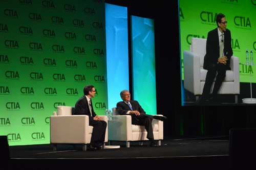
Wheeler Also Discusses Spectrum Incentive Auction on CTIA Stage
LA Times writer Jon Healey interviews the FCC’s Tom Wheeler in a fireside chat at CTIA.
As one of Super Mobility 2015’s first speakers, Federal Communications Commission (FCC) Chairman Tom Wheeler reaffirmed his support for the net neutrality rules that CTIA-The Wireless Association, the event’s host, has been fighting in court.
Wheeler harkened back to his speech to this same audience last year where he received a “less than thunderous response” to his suggestion that broadband should be classified as a public utility. Previously, the FCC had treated broadband as an information service separate from the telephone network.
“If you have that kind of a role in delivery of Internet, then you ought to be governed under a similar set of rules that apply to everyone and not have a wireless exception,” Wheeler said.
Net neutrality rules enacted by the FCC early this year prohibit mobile broadband providers from throttling Internet content and utilizing paid prioritization. CTIA filed a brief with the U.S. Court of Appeals in Washington, D.C., this summer in conjunction with other industry associations, opposing the regulation saying it could have “devastating impact on Americans and the U.S. economy.”
“Imposing Title II on wireless would be a gross overreaction that would interrupt the world’s best wireless industry and interfere with the significant innovations and competition consumers enjoy today.”
Wheeler disagreed on stage during a fireside chat with Los Angeles Times editorial writer Jon Healey. He pointed out the “tens of billions of dollars” the wireless industry has invested.
“I’m very bullish on the continued growth of this industry and the continued protection of consumers and how they use the net,” he said.
Wheeler said he was also “supremely confident” that the incentive auction for 600MHz of broadcast TV spectrum, scheduled to start March 29, 2016, would go off without a hitch and that broadcasters would be there and would agree to sell their spectrum rights. Don’t believe him? Take it from James Murdoch, new CEO of News Corp., he said.
“I told him I was going to be talking to you today, and I said, ‘Can I tell him you’re going to show up?’ and he said, ‘Yup,’” Wheeler explained to Healey. “We had a fascinating discussion about how the broadcast business has changed. The most interesting part of my conversation with…Murdoch was talking about innovation and need to be continually innovative. The broadcast auction offers incredible opportunities for broadcasters to get a pot of money to innovate with without losing the business model they’ve been successful with.”
In a late June filing with the Federal Communications Commission (FCC), Lightsquared asked the agency to reassign its spectrum licenses — which were at the root of a prolonged dispute in 2010 and 2011, and have never been fully utilized — to a new licensee that would be wholly owned by a new company, New LightSquared. This is part of LightSquared’s efforts to re-emerge from bankruptcy.
LightSquared wants to resume its own interference testing scheme, floated in 2011 after an independent, collaborative effort found ample LightSquared interference with GPS. The company has contracted with Roberson and Associates, a technology consulting firm, to develop its interference study.
LightSquared is being represented before the FCC by Reed Hundt, a former FCC chairman who served from 1993 to 1997.
LightSquared listed 28 different GPS receivers and related devices that it wants to test for interference with its terrestrial mobile broadband service. The devices include certified and non-certified aviation receivers and avionics equipment, general location, cell phones and 13 different high-precision clocks and receivers.
Hundt specificaly identifed three companies — Trimble, Garmin, and John Deere — that he wants to come forward and provide proprietary technical and business information “in confidence” to tester Roberson. In statements to the FCC, Hundt twice used the phrase “speak now or forever hold your peace.”
In March of this year, LightSquared obtained U.S. court permission to exit bankruptcy protection, which it entered in 2012. At that time, the FCC had concluded, after lengthy testing, hearings, charges and countercharges, that the wireless broadband service proposed by LightSquared would interfere with GPS signals and associated positioning, navigation, and timing.
New LightSquared reportedly has $1.25 billion in operating funds to help “make full use of its spectrum to provide existing and innovative services.”
In a recent trial involving the assets of the bankrupt company, the value of its spectrum bands was estimated at possibly $4.5 billion or higher.
GPS Industry Response. The GPS Innovation Alliance responded in early July to media reports on LightSquared’s position regarding the testing of the compatibility of terrestrial broadband and GPS.
Following is the GPS Innovation Alliance’s response:
“The GPS Innovation Alliance (GPSIA) supports a consensus-driven process, including all government and non-government stakeholders, to clearly identify and address remaining technical issues raised by LightSquared proposals to repurpose mobile satellite spectrum for terrestrial broadband use.
“The technical challenges posed by these proposals are formidable, as evidenced by the conclusions of multiple U.S. government entities. Specifically, the U.S. Departments of Defense and Transportation and the NTIA have all found in the last several years that LightSquared’s proposals have significant potential to interfere with GPS.
“Contrary to LightSquared’s recent suggestions, this is not simply a private matter between three GPS companies and LightSquared, but is important to all GPS users who rely on this critical technology every day. The Department of Transportation has sponsored an ongoing effort to assess adjacent band issues, and the GPS industry is actively engaged with the Federal Communications Commission (FCC), Department of Transportation (DOT) and other government stakeholders to drive consensus around next steps.
“While we welcome the participation of LightSquared consultants, any further analysis of the technical issues should be informed by input from all of the relevant stakeholders, rather than the one-off efforts of an interested party.”
The world of indoor location continues to evolve, with a number of variations on when and under what circumstances you might be able to wander around your local mall getting directions to your favorite ice-cream store on your iPhone. Some malls are mapped, some are not, some (most) have Wi-Fi hot-spots and Bluetooth beacons, some may be in areas where outdoor directional beacon are being tested and their signals penetrate indoors. But the thing they have in common is that most seem to lose GPS/GNSS signals once you get a few tens of meters away from the front entrance.
Some companies have managed to make indoor location in your mall work with a combination of GPS, plus all the RF signals that can be received, plus using inertial and/or magnetic sensors in your mobile phone, and sometimes also with detailed indoor map-matching — but no-one seems to do this in a simple, consistent, reproducible way for any store wanting to ensure you arrive at their door, or for a telecommunication industry wishing to standardize how it works for E911 and then field it everywhere.
So I’ve actually been looking for an indoor location outfit who might have found a consistent solution that can work from place to place — by that I mean from mall to mall, city to city, country to country, even continent to continent, and every time after first set-up — and I suspect that I may have now found one.
The team at iPosi in Denver is still working on their solution, but they have run some pretty convincing demonstrations in some very challenging locations, so they may have found an inside edge that could take them many places (sorry, about that pun).
While iPosi’s headquarters are is in Denver, the company also has labs in Boulder and offices in Dallas. It hasn’t been around too long — since 2011 — but it has been busy filing patents for the key technologies that drive their location technology. Of 40 total patents in the pipeline, five have been granted or allowed, 15 are pending, and 20 more are in development. With only six employees, iPosi is a small outfit, but it also gets design assistance from a European design center for other GNSS signal designs.
One of the key GNSS elements the iPosi team has going for them is an in-house developed GPS receiver with a sensitivity of -175 dBm. If you could get any sort of a signal deep inside a building, it’s possible that they might be able to receive it. But, for sure, anything you would receive deep inside would be just multipath – right? There are other pieces to this story however.
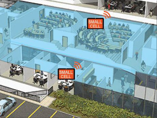
The iPosi system design is based on mobile phone “small-cell” installations. The world now has around 100 million multi-floor buildings with an average of eight floors each, and most buildings present some level of attenuation for external mobile phone cell-tower signals — never mind GPS signals. Most of us should be familiar with having to leave meetings to get “bars.” holding the phone up against a window, walking around to catch reflected indoor signals, and eventually having to leave the building and be with a group of other people who are doing the same thing – looking for a clear cell-phone signal to make a call. In the Northern U.S. and Canada in the winter, this can even be hazardous to your health!
So small cells behave as basically indoor “repeaters” of mobile phone signals. iPosi believes that an average of four of these repeaters are needed to broadcast sufficient signal on each average building floor. So iPosi embeds each small cell with one of its high-sensitivity receivers. Once positioned indoors, and over time, the receivers self-locate inside the building. Currently, installation of small cells can be somewhat cumbersome and time consuming, but non-GPS small cells can be located during installation using traditional indoor surveying techniques — such as laser-based measurements. Either that, or no measurements are made at all, and no device location information is associated with a device.
Small-cell setup.
With each small cell equipped with a high-sensitivity receiver — with especially clever algorithms to differentiate and interpret multipath over time — each device goes to work transmitting repeater mobile-phone signals and eventually self-locates. Contained within these signals are each small-cell location, plus a timing message that allows any standards-compliant handset to calculate range to each transmitter and to perform an OTDOA (Observed Time Difference Of Arrival) position fix.
If the small-cell location at install is also fed into the GIS database for the building and, more importantly, for the local area, the E911 “dispatchable address” for that building has GPS-level accuracy. And first responders will also have numerous other small-cell location aids within the building.
Another detail is that the iPosi receiver uses A-GNSS (including ephemeris) data, so it only needs small snapshots of signal to deduce position. This means very low power consumption for positioning at the small cell, which is good because small cells are mostly battery powered.
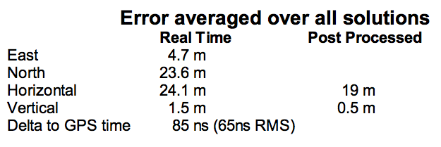
So, does it work? In FCC E911 demonstrations at the Omni Hotel in San Francisco, iPosi consistently located to within 50 meters horizontally and a few meters vertically.
Masonry, turn-of-20th-century construction
Approximately 15 floors, similar to surrounding
Test site: ninth floor hotel room
Horizontal error = 38 m, Vertical error = 9.5 m
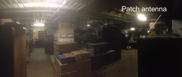
There were several other tests in representative converted apartments, a modern four-story steel and concrete building, and inside a university auditorium. But the one that really caught my attention was the test iPosi ran in the basement of an engineering center.
Engineering center, lower basement 3.5 m below grade.
That’s 3.5 meters below grade! The iPosi receiver measurement system was able to determine that some of the signals were actually received directly from a GPS satellite — unbelievable! That’s through concrete and stone down to 3.5 meters below grade with a simple patch antenna!
Most of your average mall locations are not as location-hazardous as this basement test. Its possible that finding your way to the closest indoor ice-cream store could soon be child’s play, which will be especially helpful for the kids with smartphones.
iPosi is working with some of the key equipment suppliers in the industry. It’s quite likely that some of its evaluation sites could soon evolve into operational indoor location facilities. And iPosi’s argument is that its indoor location solution is truly scalable or can be readily standardized — as the telecom companies apparently would love for all indoor location technology to be — so the iPosi solution can readily transition across borders and countries, and roll out could be greatly simplified.
Tony Murfin
Hard to say if this will be the winning indoor location solution, but in the end the market will decide if it really is a scalable, simple solution, and if it will succeed — right?
What if the U.S. government stepped in and confiscated all your bananas? Grown foreignly, they lack proper accreditation to enter this country. That they have done so for years is no excuse. They are illegal. Those who consume said bananas engage in unlawful activity. Those who facilitate such consumption — you, in this case, whom we imagine to be a vendor of shakes, smoothies, and fruit juices — are aiding and abetting, colluding, conspiring, something like that.
Bananas are no more above the law than anyone or anything else. They must fill out the proper forms.
And the same goes for all you other tropical fruits out there! If you spring from foreign soil, and if you pack exotic flavors unfamiliar and most important, unapproved, in the land of apple pie.
Today’s bananas are GLONASS signals, and the other fruits, those from other international GNSS. The PNT user community within the United States who use such multi-GNSS signals, other than GPS, technically do so illegally.
These revelations come via the U.S. Federal Communications Commission (FCC) and the National Telecommunications and Information Administration (NTIA). Some in the industry-user community have been aware of this technicality, and have been patiently awaiting a blanket waiver that would take care of the matter. The waiver will appear, we have been told, any day now.
We are waiting. Sitting, and waiting. Like good citizens of the republic.
A spokesperson for the the GPS Innovation Alliance (formerly the U.S. GPS Industry Council) stated that it, too, is very patiently waiting. “The process for securing a waiver of FCC regulations requiring authorization to receive international RNSS satellite signals was identified in an FCC Public Notice released in 2011. This process is initiated by National RNSS System providers, which have the satellite information needed to secure a waiver. GPSIA members remain fully committed to producingmulti-GNSS signal user equipment consistent with U.S. policy, and to working with the FCC and NTIA in considering these requests.”
To review the FCC/NTIA briefing: “Radio Regulator Spectrum Management Perspectives & Priorities: Emerging Trends in Spectrum-Efficient Technologies,” see www.gps.gov/governance/advisory/meetings/2014-12/.
The NTIA and FCC perform these functions on our behalf:
Allocate spectrum, while promoting new technologies and services.
Develop service rules: share spectrum while minimizing interference risks.
Assign frequencies, for interference protection among authorized stations.
Enforce rules.
Some of the frequencies used by GLONASS, Galileo, and other foreign PNT systems are not authorized for use in the United States, as they may interfere with other signals. Since they are not authorized or certified, they have no guarantee of protection in the United States. The NTIA and FCC protect users from unauthorized foreign PNT signals.
The European Union and Galileo have formally asked for a waiver and are completing the necessary paperwork.
Let’s hope that common sense prevails soon over international gamesmanship, a waiver is granted, and this all goes away. Such a waiver reportedly sits on the desk of the appropriate person. Sits and has sat.
To our mantra of location, location, location, we must add a corollary.
Report on the 14th meeting of the National Space-based PNT Advisory Board in Washington, D.C., held December 10-11, 2014.
By Ron Hatch
Ron Hatch
The December meeting of the PNT Advisory Board meeting brought forth important developments and proposals for the protection of GPS as part of the U.S. critical national infrastructure. A separate presentation made by speakers from the National Telecommunications and Information Administration (NTIA) and the Federal Communications Commission (FCC), concerning possible limitations on the use of signals from other GNSS, generated some controversy, alarm, and extensive follow-on discussion by industry, users, and other concerned parties.
Critical Infrastructure. Perhaps the most important presentation was that of Brad Parkinson, the acting chair, in his recap of the recommendations to be made by the Advisory Board to the PNT EXCOM.
The first recommendation was a reiteration of the Advisory Board opinion that the GPS be designated as one of the “critical infrastructures” of the United States. This opinion was based upon the fact that 14 of the existing designated critical infrastructures involves the use of GPS. The feeling was that such a designation would enhance the attention focused upon ensuring GPS reliability.
A second recommendation was that a comprehensive threat assessment to GPS operation be generated that can be used to assess its vulnerabilities. The remaining recommendations to the EXCOM were based upon the results of studies by the two working groups that were presented next.
The two working groups of the advisory board, specifically the “Assured Availability” and the “Economic Value of PNT” working groups, gave the next set of presentations. The Assured Availability working group was split into three sub-groups. The three aspects addressed were to “Protect,” “Toughen,” and “Augment.” The Protect working group recommended action to encourage the reversal of European initiatives to authorize pseudolites that broadcast within the GNSS L1 frequency band. Since such pseudolites would constitute authorized interference to standard GNSS receivers, it was recommended that our State Department encourage a reconsideration of the pseudolite proposals and that they be constrained to operate on a frequency outside the L1 frequency band.
The Toughen working group looked at a number of measures by which GNSS receivers could be improved to better withstand intentional and unintentional interference. Phased array antennas, inertial aiding and various software tracking improvements were discussed. An invited presentation by Gary McGraw of Rockwell addressed some of these issues particularly from a military perspective. An additional invited presentation upon the requirements for precise time-keeping in trading of financial transactions was presented by Andrew Bach.
The Augment working group discussed a number of ways in which the GNSS capabilities could be augmented. Prior recommendations that eLoran should be maintained as a backup was again strongly recommended. In addition, the ability to track other GNSS satellites in addition to GPS satellites was encouraged, even though it was recommended that special precautions and automated checks needed to be implemented in the light of the system failures that have been noted with the GLONASS satellites. A very interesting invited presentation by Robert Lutwak of the Defense Advanced Research Projects Agency (DARPA) described the continuing progress toward higher precision inertial sensors.
The second working group, the Economic Value of PNT, reported on firmed up plans to strengthen the existing studies of the economic value of PNT by engaging the economists resident within the various cabinet departments within the EXCOM to which the Advisory Board reports. The detailed plans were given in a presentation by Irv Leveson that outlined the plans for “A Comprehensive Quantitative Economic Assessment of GPS.”
It is not my intention to slight any of the other presentations, but I felt two of the remaining presentations were very important. Specifically, the presentation by Karen Van Dyke on Department of Transportation plans regarding “Adjacent L-Band Compatibility and GPS Signal Monitoring” was very encouraging. Among other items, it indicates that adjacent band-power limits will be carefully analyzed and tested to ensure that all existing applications of GPS will not be harmed.
FCC on International Signal Use. The second presentation that I felt was very important was by Paige Atkins of the National Telecommunications and Information Administration (NTIA) and Ronald Repasi of the Federal Communications Commission (FCC). Their presentation was titled “NTIA/FCC Spectrum Management Perspectives.” The presentation covered the background and intent of the various authorizing legislation. There were, however, some disturbing comments made.
Specifically, the item on the slide about National Space Policy that had a major bullet: “Guidance to all departments and agencies – ‘maintain and enchance’ space-based PNT systems. To this end the U.S. shall (among other things)…” There were two sub-bullets.
The first addressed GPS protection as a critical infrastructure component. The second sub-bullet stated “Foreign PNT services ‘may be used to augment and strengthen the resiliency of GPS.’” The verbal transcript is not yet available, but it seemed to me that Ron Repasi minimized this statement by indicating that resilience was subject to interpretation.
The real alarm was in his following comments during the question-and-answer discussion, where he indicated that the use of GLONASS within U.S.-based receivers was not authorized and that, therefore, the frequency band they used was not necessarily subject to protection. In addition, it was indicated that three years ago, procedures were developed whereby one could apply for authorization to the use the GLONASS signals. To date, Ron Reposi indicated that no organization had applied for authorization to use GLONASS, and that therefore it was currently illegal to use it.
Significant discussion was generated by the above, both following the presentation and the next day in a recap. From the discussion, it appears that a March 2011 regulation outlining the requirements for authorization of receiving “Earth stations” is being interpreted by the FCC as requirements for authorization of GLONASS receivers.
[Editor’s note: The process for securing a waiver of FCC regulations requiring authorization to receive international RNSS satellite signals was identified in an FCC Public Notice released in 2011. This process is initiated by National RNSS System providers, which have the satellite information needed to secure a waiver. Members of the GPS Innovation Alliance (GPSIA, www.gpsalliance.org, formerly the U.S. GPS Industry Council) have stated that they remain fully committed to producing multi-GNSS signal user equipment consistent with U.S. policy, and to working with the FCC and NTIA in considering these requests.]
In light of the multitude of GLONASS receivers already in use, including a number of U.S. government and agency receivers, the discussion was primarily on what should be done next. The decision taken was not to panic, but to bring the problem to the attention of the various government departments represented on the EXCOM and proceed with some caution.
The possibility was raised that NASA, in conjunction with the State Department and other interested parties, could seek a blanket authorization to use GLONASS within GPS receivers. This was discussed and presented as a possible way forward. Clearly, the issue is one that will be followed with great interest.
The FCC will soon make a ruling on indoor location rules for 911 calls. If you worked in the location industry in the late 1990s, you may remember when the FCC ruled that wireless carriers would have to automatically locate a mobile phone that dialed 911 from the outdoors. From a seat on the E9-1-1 Institute’s board, a non-profit organization that supported Congress on 911 public safety issues, I watched the wireless carriers fight meaningful 911 location accuracy standards and monitoring.
With the large number of calls to 911 from the indoors today, the FCC is about to require carriers to automatically provide emergency dispatchers with indoor location information on calls. In the short term, the FCC is proposing indoor location that would provide sufficient information to identify a building, with more granular accuracy in the long term at the room or office suite level. In addition to horizontal locations, the FCC proposes adding vertical location, a critical metric for multi-storied buildings.
The comment period for the FCC’s proposal just ended and it is now up to the agency to act. During the comment period, carriers, public safety entities and vendors fought over accuracy rules and monitoring. NENA and APCO, leading public safety organizations, negotiated a consensus agreement on indoor location rules that many other prominent public safety agencies have decried as objectionable. It is surprising that NENA and APCO would sign on to such a watered-down version of the FCC proposal.
On a better note, indoor location for commercial applications is an industry bright spot. Hyper-location is king and is moving beyond retail to enterprise, personal asset tracking (please find my keys) and the connected home. “Over the past 12 months there has been a considerable change in deployments as companies have moved from a handful of deployments to getting into the hundreds and thousands of stores,” said Patrick Connolly of ABI Research.
In 2015, Connolly also expects to see camera analytics companies like Shoppertrak, Irisys and Brickstream have an increasing presence as they expand their offerings into BLE, Wi-Fi and in-store analytics. LED lights for location positioning within retail outlets and large public venues are on Connolly’s list for market growth in the coming year. The lights enable communication with the cameras on customers’ smartphones to determine their locations. Retailers can send information, redemptions, maps and services to customers via their mobile device at precise locations within the store.
I’d like to close the year with a “departure.” In Los Angeles, a proposed cemetery on the tony bluffs of Malibu would forego headstones, raised or flat, and depend on the grieved using GPS to find the burial spots of loved ones. A small disc on the plot would verify the coordinates. GPS as we didn’t imagine it.
Crowds streamed into the Sands Expo and Convention Center, Las Vegas, to the sounds of ’80s music icon Thomas Dolby and a string quartet covering the ’90s hit “Bittersweet Symphony,” but the buzz wasn’t about the morning keynote speech that would kick off CTIA Super Mobility Week. Instead, the impending Apple Live Event had taken over as a countdown clock ticked on the big screen.
The Apple circus — though alluded to in introductory remarks by CTIA Chairman Dan Mead, CEO of Verizon Wireless, and CTIA President Meredith Atwell Baker — would have to wait. First on the agenda: Several topics affecting the industry, with an emphasis on spectrum allocation.
Atwell Baker set up the three-day show, the first combining the CTIA conference with MobileCON. She cited dozens of figures about the incredible growth of the industry before focusing in on the need for a successful spectrum incentive auction with projected 886% mobile data usage growth by 2019.
“The U.S. had the third-lowest amount of spectrum dedicated to LTE,” she said. “How do we close the gap? The AWS-3 and 600MHz auction are a great start. We hear the wireless carriers may sit out of these auctions. Really? Given our track record, I’m incredulous wireless carriers wouldn’t bring billions of dollars to these auctions.”
The Federal Communications Commission (FCC) has been pushing for the spectrum incentive auctions to reallocate spectrum from television broadcasters to wireless providers for ever-increasing mobile usage.
In introducing Tom Wheeler, chairman of the FCC, Atwell Baker lauded his determination to bring the auctions to fruition.
Wheeler jumped right into his list of the Top 3 issues facing the business for the standing-room only crowd: the incentive auction, net neutrality and competition in the wireless industry.
Wheeler balanced his concerns with equal doses of praise, lauding CTIA for a “very thoughtful” paper arguing that mobile broadband should not be subject to the same rules as fixed broadband while alternately questioning why some consumers have been led to believe they have unlimited data usage or why others are targets for throttled usage.
“I’m hard-pressed to understand how either practice, much less the two together, could be a reasonable way to manage a network,” he said.
He also touched on the need to keep competition alive in the business and avoid the “walled gardens” of the past that created barriers to entry in the market.
“Where competition exists the commission must protect it. This industry has always told policymakers, ‘We’re different, we’re competitive, but in the last couple of years the FCC and Department of Justice had to be poised to protect that dynamic.”
Wheeler pointed out the wireless industry’s $260 billion 10-year infrastructure investment as “living proof that profit and progress can go hand in hand” before concluding on the topic of a shared front: spectrum allocation.
“Our greatest public asset is that which we cannot see: Spectrum. Your government has heard your cry for more spectrum. The Congress responded with a creative and courageous solution,” he said, “an incredibly complex, never-before attempted undertaking.”
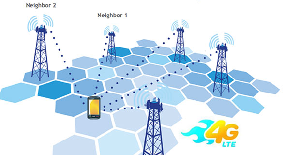
LTE brings a promise of improved location accuracy with new positioning technologies and their integration using hybrid techniques. Although established technologies such as A-GNSS (A-GPS and A-GLONASS) provides excellent performance in environments with a clear view of the sky, performance is often poor indoors, where detection of satellite signals is limited. In LTE, current standards support Observed Time Difference of Arrival (OTDOA), an advanced cellular positioning technology that can augment A-GNSS and provide a more accurate location fix for indoor scenarios.
With large-scale VoLTE rollouts imminent, leading operators are confronted with the need for extensive and complex testing of LTE positioning technologies to ensure VoLTE E911 works well from day one. Additionally, the FCC, whose current E911 regulations apply only to outdoor environments, has proposed stringent indoor requirements as a response to increased mobile usage for emergency calls and lack of accurate positioning information on calls that originate indoors.
“Roughly 70 percent of 911 calls are placed from wireless phones and a majority of these calls originate indoors, so there is a real urgency in providing better location accuracy for mobile users, wherever they are calling from,” said Nigel Wright, vice president at Spirent Communications. “Spirent is currently working with all the key industry players to evaluate OTDOA and its integration with other positioning technologies, and to enable operators to meet the location requirements for VoLTE E911 and the evolving FCC requirements.”
Spirent 8100 LTS has won widespread acceptance as the leading platform for location testing in the wireless industry, and with this latest capability is now able to support OTDOA Position Calculation Function (PCF). Minimum performance testing for OTDOA looks only at the raw measurements from the device, whereas use of OTDOA PCF enables full verification of a device’s position accuracy performance. Recognizing its importance, leading carriers have established their own OTDOA positioning performance requirements beyond bare minimum standards. Ensuring that devices fully meet these requirements as well as the evolving FCC regulations for E911 requires comprehensive testing.
First, Lockheed Martin began investigating options for its GPS III payload supply line last year. Then in June of this year, the U.S. Air Force opened a “sources sought” initiative for a production-ready GPS space vehicle, equipped with an alternate payload, for consideration alongside the Lockheed Martin-built GPS III vehicle. Grumman and Boeing have responded to the U.S. Air Force call. Now the U.S. Senate has jumped into the act, with a 2015 defense spending bill that directs the Air Force to allocate at least $20 million for work on a space-based “digital navigation instrument” as a possible alternative to the payload developed for the GPS III satellites.
The Senate Appropriations defense subcommittee stated that it “believes that early Air Force investment, when combined with industry investment, into the development of a digital navigation payload will significantly reduce cost and schedule risk for the future GPS constellation.” What exactly is meant by a “digital navigation payload” — as opposed to the current payload under construction — is unclear. The systems on earlier GPS satellites probably used some analog components. Even modern receivers have an analog front end before the analog-to-digital converter. Perhaps the Senate Appropriations subcommittee wants more digitization in the nav unit.
Disaggregation. Further, the committee “firmly believes that movement away from large satellites, where possible, will result in significant cost savings and reduce the schedule to deliver payloads into orbit.”
This idea calls for dispersing space capabilities away from large platforms and into smaller ones.It would require, at the very least, a new constellation architecture for GPS III, an as-yet unexplored concept.
Status. Lockheed Martin is under contract to deliver the first eight GPS III satellites, but the award for up to 22 further IIIs remains open. Difficulties with the payload for the first batch of satellites mean that although Lockheed has three space vehicles ready, it has no signal payload to put aboard them. Subcontractor Exelis is at work on that.
Lockheed Martin spokesperson Chip Eschenfelder has stated that “signal cross talk issues are resolved. The SV01 navigation payload forecast delivery to Lockheed Martin is fall 2014. Once the first navigation payload is delivered, we are into the production phase.”
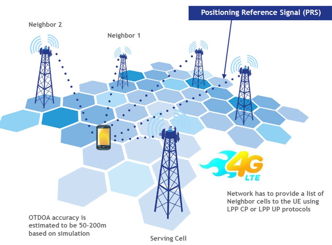
General John E. Hyten
General Support. At June’s ION Joint Navigation Conference, General John E. Hyten, currently vice and soon to be commander of USAF Space Command, while evincing unqalified support for the system operators, did not address the GPS III manufacturing and supply issue. He confined his industry-related remarks to warning commercial PNT vendors and government program managers to cease placing commercial GPS receivers in critical government systems that support warfighters, government users, and critical national infrastructure.
He strongly advocated for Selective Availability Anti-Spoofing Modules and M-Code to help secure these critical systems against interference, jamming and spoofing, and urged manufacturers to build their devices in strict adherence to the U.S. government’s ICD process.
FCC Seeks Spectrum but Supports GPS
In a June 20 workshop on “GPS Protection and Receiver Performance,” the U.S. Federal Communications Commission (FCC) reiterated the need to safeguard critical infrastructure and public safety — two key uses of GPS.
Despite fears that the FCC would call for new GPS receiver standards, the meeting took a protective and conciliatory tone, even as the FCC continues to seek more frequencies for mobile broadband, citing the need “get more out of the radio spectrum.”
FCC Chairman Tom Wheeler stated, “Today is not about FCC-mandated receiver standards. Rather it is about the best way to protect GPS operations in the context of evolving technology and adjacent spectrum activities.”
The specter of adjacent spectrum use hovered through the day, fully appearing in LightSquared and administration presentations. Otherwise, scant mention was made of the 2012 notion that GPS receivers should be modified to stop alleged “peeking” into adjacent spectrum.
Panel discussions focused on GPS in critical infrastructure and public safety, with presentations by Qualcomm, Motorola, and AT&T. Speakers from T-Mobile, Spirent, Garmin, NovAtel, and John Deere covered GPS’s role in timing and the power grid, financial markets, telecommunication network, and precision agriculture. Paul Galyean of Deere said that “Certainty on the spectrum environment is needed. It’s difficult to design for the future without it.” If GPS receivers had to filter out cellular activity, this “might impact sensitivity, involve excessive size or cost, and might cause distortion of GPS measurements.”
Chris Hegarty, MITRE Corporation, gave a compelling argument for not overhauling receiver methodology: the extremely long lead times for commercial passenger aircraft. “Until 2022 every new Boeing and Airbus is going to fly off with $250,000 worth of navigation equipment that has three $50,000 GPS receivers and antennas and everything else, and they are going to want to use that for 20 to 25 years. So, you have a timing issue. Even if we all decided today that we wanted to do that, some communities simply aren’t going to be able to get it into place until we’re all dead.”
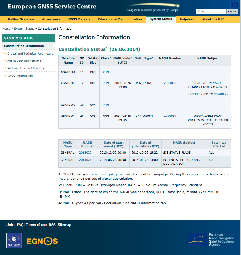
Power Loss Strikes Galileo Satellite
In-Orbit Validation Vehicle May Be Lost to Further Use
The disappearance of signals from Galileo GSAT0104, the fourth in-orbit (IOV) Galileo satellite, arose from a sudden, unexpected loss of power aboard the space vehicle. The exact cause is unknown, or at least unreported as of press time. Some have speculated that the cause could lie in a failure of components around the solid-state power amplifier, including the output multiplexer, cables, or antenna.
If such proves to be the case, ground operators may be powerless to repair the problem. The satellite would be a total loss.
The power outage flashed on May 27, shutting down the satellite’s E1 signal. The signal “re-established itself almost immediately. But as soon as it was back in service, the two other channels’ power dropped and did not recover. The full satellite then was shut down by ground teams,” reported correspondent Peter de Selding.
Looking for a Fix. European Space Agency (ESA) officials stated on July 3 that they would power-on the satellite again during the week of July 7–11 to continue an investigation into the problem, but there have been no subsequent reports. Investigation has been ongoing since the shutdown but has not identified a cause; officials state they have established that it is not related to the onboard atomic clocks.
The four IOV satellites currently aloft differ in both technology and manufacturer from the next phase of Galileo satellites to be launched. The GSAT0104 satellite now in silent orbit was built by Astrium. The newer, operational satellites are produced by OHB-System, following a different payload design. Two of the newer generation are at the Guyana spaceport awaiting a possible late August lift date.
Reporting History. The possibility of a satellite failure was first floated in the June 30 EAGER newsletter (European GNSS and Earth Observation Report), by contributing editor Tim Reynolds. He wrote:
“Has anyone heard anything from Galileo GSAT0104 recently? According to the European GNSS Service Centre, the fourth IOV satellite is ‘unavailable until further notice.’ The setting of unavailability may be due to in-orbit validation testing, as the website implies may be the case, but no further official statement has appeared, nor active user notifications (NAGUs) at http://www.gsc-europa.eu/system-status/user-notifications.”
Two days later, GPSWorld.com posted a follow-up story: “According to reports, the root cause of the outage is under investigation. Some unofficial sources have gone so far as to speculate that GSAT0104’s useful transmission life may be over.”
Then, on July 3, correspondent Peter de Selding (who also contributes to EAGER) reported in Space News, after questioning sources at ESA, that the trouble aboard the fourth IOV Galileo satellite arose from a sudden, unexpected loss of power, as stated in the first paragraph of this article.
Largest Fine in FCC History — $35M — for Chinese Jammer
The Federal Communications Commission (FCC) plans to issue the largest fine in its history against C.T.S. Technology Co., Limited, a Chinese electronics manufacturer and online retailer, for allegedly marketing 285 models of signal jamming devices to U.S. consumers for more than two years.
The FCC applied the maximum fine allowed to each jammer model allegedly marketed by C.T.S., resulting in a planned fine of $34,912,500.
“All companies, whether domestic or foreign, are banned from marketing illegal jammers in the U.S.,” said Travis LeBlanc, acting chief of the Enforcement Bureau. “Signal jammers present a direct danger to public safety, potentially blocking the communications of first responders. Operating a jammer is also illegal, and consumers who do so face significant civil and criminal penalties.”
C.T.S. operates a website that markets consumer electronics to individuals in the United States, where it allegedly misled U.S. consumers by falsely claiming that certain signal jammers were approved by the FCC. In fact, the use of such devices by U.S. consumers is illegal under any circumstance. C.T.S. also sold 10 high-powered signal jammers to undercover FCC personnel.
The FCC also is ordering C.T.S. to cease marketing illegal signal jammers to U.S. consumers and provide information to the FCC about any persons and entities in the United Sates that purchased its devices.
Signal jammers are radio frequency transmitters that intentionally block, jam, or interfere with authorized communications, such as cellphone calls, GPS systems, Wi-Fi networks, and first responder communications. It is a violation of federal law to market, sell, import, or use a signal jammer in the United States and its territories, except in very limited circumstances involving federal law enforcement.
The FCC asks people to report the sale or use of an illegal jammer by contacting the FCC Enforcement Bureau through the FCC online complaint portal, or by calling 1-888-CALL-FCC (or 1-888-225-5322). To voluntarily relinquish a signal jammer, e-mail [email protected]. Additional information, including a Consumer Alert and Enforcement Advisory to retailers, is available at www.fcc.gov/jammers.
The U.S. Federal Communications Commission convened a June 20 workshop on “GPS Protection and Receiver Performance” whose bite turned out to be far less than its bark had led some in the GPS industry to fear. The hastily assembled workshop — three weeks notice was given — appeared at first notice to derive from the call for “GPS receiver performance standards” that was one of the outcomes of the LightSquared controversy of 2012. The FCC chief emphatically noted, however, before anyone else could say anything, that the meeting was “not about FCC-mandated receiver standards.” A nearly audible sigh came from the collected dignitaries.
Perhaps the slotting of “GPS Protection” into first position within the workshop’s title might have given some clue. The meeting did turn out to be a less-than-alarming gathering of stakeholders, and in fact a reiteration of the need to emphasize and safeguard critical infrastructure and public safety — two key uses of GPS.
Two weeks prior to the workshop, Brad Parkinson declared to the National Space-Based Positioning, Navigation, and Timing (PNT) Advisory Board that “A number of manufacturers are quite panicked over this because of the possibility of some superposition of, in essence, how you design a receiver for GPS. This could vastly affect the whole substance of what we are if carried to the point that someone dictates how you design a receiver. I think that’s kind of dangerous.”
But the meeting, in the end, took a positive, protective, and conciliatory tone, even as the FCC continues beating the drum for more frequencies for mobile broadband, citing the need “get more out of the radio spectrum.”
“Today is about federal and non-federal leaders coming together to discuss successful industry-driven collaborations and GPS receiver performance,” said FCC Chairman Tom Wheeler in his opening remarks. “These are not abstract issues. But let me also be specific about what today is not. It is not about FCC-mandated receiver standards. Rather it is about the best way to protect GPS operations in the context of evolving technology and adjacent spectrum activities.”
The specter of adjacent spectrum use hovered intermittently throughout the day, appearing fully in the presentation by LightSquared and one from the President’s representative. Otherwise, scant mention was made of the oft-expressed 2012 sentiment that GPS receivers needed to be modified in the way they work, to stop their alleged “peeking” into adjacent spectrum.
Peekin’? We don’t need no steenkin’ peekin’!
After further introductory remarks from the FCC’s head of Public Safety and Homeland Security Bureau, the audience heard a technology market update from the U.S. Consumer Electronics Association (CEA). The report relied almost entirely upon the European GNSS Agency’s (GSA’s) 2013 GNSS Market Report for its global statistics, while displaying some domestic charts of its own. Among the conclusions: GPS/GNSS is an enabling technology for innovation and disruption; and the consumer market, defined as road and location-based services (LBS), represents the biggest opportunity. The CEA presentation is available here.
The morning’s first panel discussion focused on the importance of GPS for critical infrastructure and public safety users, with presentations by Qualcomm, Motorola, and AT&T in addition to various government agencies. Cormac Conroy, vice president at Qualcomm, emphasized the critical role of GPS in emergency calls from mobile phones (E-911) and what he called “enhanced location services”: vehicle and pedestrian navigation, location-based alerts and reminders, and location as context in mobile apps.
Other speakers, including representatives from Ericsson, T-Mobile, Spirent, Garmin, NovAtel, and John Deere, covered GPS’s role in timing and thus controlling the nation’s power grid, the financial markets, the telecommunication network including cable TV, and the national breadbasket, precision agriculture. Paul Galyean of Deere said that “Certainty on the spectrum environment is needed. It’s difficult to design for the future without it.” And further, if GPS receivers had to filter out cellular activity, this “might impact sensitivity, involve excessive size or cost, and might cause distortion of GPS measurements.” The Deere presentation is available here.
Chris Hegarty from the MITRE Corporation gave one of the day’s most compelling arguments for not overhauling GPS receiver methodology: the extremely long lead times for commercial passenger aircraft. “Until 2022 every new Boeing and Airbus is going to fly off with $250,000 worth of navigation equipment that has three $50,000 GPS receivers and antennas and everything else, and they are going to want to use that for 20 to 25 years. So, you have a timing issue. Even if we all decided today that we wanted to do that, some communities simply aren’t going to be able to get it into place until we’re all dead.”
White House Espouses Adjacent Spectrum
Tom Power, deputy chief technology officer for telecommunications, held up the banner for “efficient use of spectrum” and pronounced the Administration opposed to “listening in.” Ironic, given its other proclivities. He advocated against some technologies exerting undue elbow room on “nearby users who want to make a change.”
An independent study of indoor tests of a hybrid wireless location technology was submitted today to the Federal Communications Commission (FCC) by wireless location engineering firm TechnoCom. The study demonstrates that existing technologies can satisfy location requirements within the timeframe proposed by the FCC in its draft rule on indoor 911 accuracy for wireless calls, according to True Position, which commissioned TechnoCom to perform the testing.
Multiple wireless carriers have challenged the technical feasibility of the proposed rule, claiming that existing technologies cannot satisfy the proposed accuracy requirements, with a spokesperson for the industry trade association claiming the rule represented “aspirational target setting.”
The results filed today by TechnoCom disprove those assertions, showing that viable technology exists in the market today, True Position said. According to TechnoCom’s findings, “The outcome is a current overall performance that readily meets the FCC’s proposed location performance threshold for indoor wireless E911 at the 67th percentile. The demonstrated performance even comes very close to meeting the 50 meter threshold at 80%, which is intended for 5 years from adoption of the proposed rules.”
Multiple other vendors have submitted filings to the FCC claiming that their technologies would also satisfy the requirements of the rule on the timeline proposed by the FCC.
“These results should prove helpful to the FCC as it moves toward reaching a resolution on its proposed rule on indoor location requirements,” said Craig Waggy, CEO of True Position. “We know that accurate location information is vitally important to American consumers, and that the FCC is intent on remedying the lack of wireless indoor location requirements for calls placed to 911 from wireless devices.”
The tests were conducted using True Position’s commercially available Uplink Time Difference of Arrival (UTDOA) technology standalone, and a hybrid solution consisting of Assisted GPS (A-GPS) and UTDOA technologies, and included indoor testing in both urban and suburban environments in Wilmington, Delaware, and surrounding areas.
For the testing, buildings of varying sizes, construction materials and use were selected by the independent firm, and a total of 62 test points were selected among 16 buildings. In all cases, the test buildings and test points remained anonymous to True Position until the conclusion of the testing and delivery of all results to the independent firm.
In early 2013, TechnoCom conducted the indoor accuracy testing for the FCC’s Communications, Security, Reliability and Interoperability Council (CSRIC). The same location and measurement methodologies were used in these tests.
The FCC has estimated that 10,000 lives could be saved each year if calls made to 911 from wireless phones had accurate location information.
 Prince’s death on April 21 highlights a fatal flaw in the United States’ antiquated 911 emergency system. When you call from cell phone, 911 doesn’t automatically know where you are. 911 often can’t determine the location of an emergency, even when the call for help comes from a GPS-equipped smartphone. Often the 911 operator can only zero in the nearest cell tower, which can be several miles away or in the next county.