Free-to-use maps from more than 40 European countries will be made available through a new online gateway.
Open Maps for Europe will signpost and provide easy access to pan-European open data created using official map, geospatial and land information.
The project, which is co-financed by the Connecting Europe Facility of the European Union, is coordinated by EuroGeographics, the voice of European National Mapping, Cadastral and Land Registration Authorities, in partnership with the National Geographic Institute (NGI) Belgium.
Users will be able to access the data, created by the not-for-profit membership association, through an online interface developed by thinkWhere. The specialist in open source geographic information system (GIS) technologies will deliver the enhanced gateway for discovering, viewing, licensing and downloading the open datasets after winning an open tender.
The open data will include topographic data, a digital elevation model, imagery, a cadastral index map, and a regional gazetteer. The first maps are expected to be available in summer 2021.
“As the official national sources of map, cadastral and land information, our members’ data is fundamental to the everyday lives of people across Europe,”said Angela Baker, program manager, Data Access and Integration, EuroGeographics. “We may not always realise it, but their authoritative information underpins our public services, provides certainty of property ownership and helps to save precious time and potentially save lives when responding to emergencies. In an ever-connected world, it is also increasingly used in a wide range of applications relied upon by both citizens and businesses.”
“The Open Data Directive recognises that the value of data lies in its use and re-use. By providing easy access to free to use harmonised maps for Europe, our members want to boost the development of these innovative services. Their aim is to encourage greater use of their official geospatial data to drive market development and economic growth, and increase competitiveness by reducing costs.
“By working to ensure their data is interoperable, readily available and easily accessible, they are demonstrating a commitment to delivering Open Maps for Europe both now and in the future.”
Alan Moore, Chief Executive, thinkWhere added: “We are delighted to be working with EuroGeographics and its members on the Open Maps for Europe project where the primary aim is to drive up the use of official geospatial and open data.”
“Our mission is to make geographic data highly accessible, easy to use and an essential part of your information architecture. Collaborating with EuroGeographics and its members we will harness the power of our cloud-based geospatial data infrastructure and drive the development of a user-centric portal that makes it easy to find, view, publish and share the rich suite of pan European digital mapping, cadastral and topographic datasets.”
Open Maps for Europe runs until Dec. 31, 2022.
EuroGeographics is an international not-for-profit organization and the membership association for the European National Mapping, Cadastral and Land Registry Authorities. It brings together members from 46 countries, covering the whole of geographical Europe.
Release follows $1 billion Innovyze acquisition announcement by Autodesk
Water infrastructure software company Innovyze has released Info360.com, a cloud-based, artificial intelligence-powered platform for real-world water lifecycle management.
Combined with Info360 Insight, a data visualization and workflow solution, the platform enables dynamic digital twins for the water industry.
Dynamic Digital Twins are virtual models of real-world assets and systems that can learn and adapt to changing circumstances. Built upon Amazon Web Services (AWS), Info360.com is uniquely designed to support Dynamic Digital Twins by gathering and unifying asset information, connecting live and historic performance data to Innovyze as well as third-party applications.
Autodesk Inc. announced March 1 it signed a definitive agreement to acquire Portland, Oregon-based Innovyze for $1 billion net of cash subject to working capital and tax closing adjustments. Autodesk’s digital-twin strategy creates a clearer path to a more sustainable and digitized water industry, the company said.
This context-aware platform can predict future performance using synchronized computational models that become more intelligent as they’re used. Info360.com provides recommended best-case actions that can help water utilities maintain the highest levels of service, capacity and efficiency.
Due to water system complexity and static operating budgets, many water utilities have struggled to adopt the digital transformation technologies that would allow them to improve predictability and performance. Using the power of the cloud, Info360.com is financially and operationally more accessible, powerful and flexible than traditional on-premise systems.
“The complex, physical properties of water and massive, underground infrastructure that must be monitored and managed make digitization extremely challenging for water utilities,” said Colby Manwaring, Chief Executive Officer at Innovyze. “We’ve combined 35 years of expertise in water management with the power of the cloud to bridge the data and technology gaps that have kept water utilities from truly capitalizing on Digital Twins with our new Info360.com platform. This is a game-changer in making digital transformation achievable for water utilities of any size.”
The new Info360 Insight SaaS application provides utilities with customizable dashboards and KPIs that track and visualize the real-time performance of the entire water distribution system. Performance data can be used and analyzed for daily operations, such as pipe break detection and water loss. The same data can also be used to plan for future maintenance and capacity fluctuations, with seamless integration into the hydraulic model.
“Info360 Insight is the first of several SaaS applications we’re delivering for the Info360.com platform, all offering advantages to utilities like easy onboarding, infinite scalability, and rigorous security out of the box,” said Rick Gruenhagen, CTO at Innovyze. “Better yet, the Info360 platform architecture incorporates cutting-edge technologies like predictive analytics and artificial intelligence tuned specifically for the water lifecycle, allowing utilities of all sizes to stay at the forefront of innovation without the need to maintain complex software or hire hordes of IT experts. As a result, utilities will have the technology foundation they need to deliver the highest possible service at the lowest possible cost.”
Info360 Insight provides real-time ingestion and analysis of SCADA data, along with 24/7 event monitoring, enabling utilities to detect incidents within their infrastructure. The system can check multiple resolution scenarios and apply recommended actions to resolve the failure as quickly as possible — ensuring a higher level of service and reliability.
In the latest edition of this classroom textbook, Getting to Know ArcGIS Desktop 10.8 guides students and professionals through the fundamentals of making maps and analyzing data using the latest Esri ArcGIS Desktop software.
The comprehensive, hands-on tutorial, moves readers from basic GIS concepts to sophisticated GIS analysis. Readers gain practical knowledge about ArcGIS Desktop tools and functionality. Exercises address querying map data, making map layouts, symbolizing and labeling maps, setting map projections, creating and sharing web maps, building and editing geodatabases, and analyzing geospatial data.
Data for completing the exercises and a 180-day free trial of ArcGIS are also available for download.
Hexagon’s Geospatial division has launched M.App Enterprise 2021, a significant update to its platform for creating geospatial and location intelligence applications. The latest release features new browser-based 3D capabilities and enhanced visual effects, plus the ability to create and configure custom applications more easily.
M.App Enterprise 2021 adds complete and seamless integration with Hexagon’s LuciadRIA. Now, users can access LuciadRIA’s 3D features, including support for panoramic imagery, shading, ambient occlusion and other visualization effects, to build browser-based solutions with no development necessary.
The latest version also features a new browser app configurator that makes it even easier to create spatio-temporal dashboards, known as Smart M.Apps. Additionally, Feature Analyzer has been expanded to allow users to add and manage multiple datasets on the fly and set up workflows. These enhancements enable more dynamic configurations, allowing field workers to be alerted quickly when action is required.
The city of Klagenfurt, Austria — a long-time Hexagon customer — has already begun using M.App Enterprise 2021 to create a city app platform that features a detailed 3D urban landscape of the entire city.
“This opens up endless possibilities for applications to automate several manual processes within different departments of the city,” said Günter Koren, head of the department of surveying and GIS at the city of Klagenfurt. “We believe M. App Enterprise will be an essential step in our journey to become a smarter, safer city for our 100,000 citizens.”
The latest release contains other new features and improvements, including an overhauled style editor, a new default dark theme, options for customized theming and full support for SAP HANA databases.
“M.App Enterprise 2021 helps organizations achieve smart monitoring of their cities, infrastructure and services by seamlessly incorporating location intelligence into enterprise systems and workflows,” said Georg Hammerer, chief technology officer of Hexagon’s Geospatial division. “With augmented visuals and dynamic configurations, this new version of M.App Enterprise can help customers easily set up powerful applications, allowing them to be more productive and efficient.”
SPH Engineering has released a UgCS update, adding support for the DJI M300 commercial drone. UgCS supports all flight planning patterns of the DJI M300, such as photogrammetry, corridor mapping and facade inspections.
UgCS allows to manage the following route parameters: speed, altitude, heading, camera attitude, camera triggering modes (by time, and by distance), turn types (Stop & Turn or Adaptive Bank turn).
“It also supports video recording in full-motion video format,” said Alexei Yankelevich, head of software development at SPH Engineering. “The drone is smart and safe, equipped with various cameras and sensors.
UgCS support for DJI M300 cameras covers:
displaying videos from both FPV and main camera (H20/H20T) on the UgCS for DJI screen;
switching between main camera lenses: wide, zoom, thermal (for H20T);
changing general settings of the active lens;
manual camera triggering in all modes (wide/zoom/thermal)
video recording
‘We have tested DJI M300 in various scenarios and can confirm that it can be used in extreme weather scenarios,” Yankelevich said, “including low temperatures while battery capacities are significantly improved.”
The most awaited improvement is Waypoints 2.0 which allows users to create up to 65,535 waypoints and set multiple actions for one or more payloads. This improvement is crucial for UgCS as it allows the drone to fly long routes in terrain- following mode with UgCS.
A major geospatial conference encompassing previous annual conferences is scheduled for 2022.
The AEC Next Technology Expo & Conference, International Lidar Mapping Forum and SPAR 3D Expo & Conference will unite as one show. The new Geo Week show will also encompass partners U.S. Institute of Building Documentation (USIBD) and American Society for Photogrammetry and Remote Sensing (ASPRS).
Geo Week, which takes place Feb. 6-8, 2022, in Denver, will bring together the best of 3D technology for the built world, geospatial applications and more. The joining of the events reflects the increased integration between the built environment, advanced airborne/terrestrial technologies and commercial 3D technologies, according to organizers.
Geo Week will provide education, technology and resources for professionals in industries including AEC (architecture, engineering and construction), asset and facility management, disaster and emergency response, Earth observation and satellite applications, energy and utilities, infrastructure and transportation, land and natural resource management, mining and aggregates, surveying and mapping, and urban planning/smart cities.
“We’ve witnessed the growing convergence between geospatial and the built world, and we received positive feedback from customers about holding the events together, which had been the plan for 2020 and 2021 before the pandemic forced us to cancel due to the unavoidable consequence of the worsening magnitude of the public health and safety issues caused by the COVID-19,” said Lee Corkhill, marketing director at Diversified Communications.
“We believe the market is ready and eager for this next step of leveraging the confluence of what are becoming ubiquitous technologies for improved collaboration, increased efficiency, and better outcomes,” Corkhill continued. “Much of the conference content and technology being showcased will reflect and support this increasing integration.”
Blue Marble Geographics has released version 22.1 of Global Mapper, a GIS application that provides both novice and experienced geospatial professionals with a comprehensive array of spatial data processing tools.
Globe Mapper provides access to a variety of data formats and includes numerous spatial analysis tools at a genuinely affordable price.
The version 22.1 release includes enhancements to the software’s 3D Viewer including, a new Save 3D Views function and 3D View navigation tools to target the camera on specific features and lock the pivot axis around a feature of interest.
The data graphing and charting feature has been updated with support for creating graphs from multiple layers, and several new spatial operations functions have been added, including Union and Difference. As with previous releases, numerous new data formats are now supported including, support for exporting to COG (Cloud-Optimized GeoTiff) format and importing of IFC (Buildings) and GeoSLAM files.
“Every release of Global Mapper demonstrates Blue Marble’s commitment to continually expanding our software,” said Patrick Cunningham, Blue Marble President and CEO. “Version 22.1 includes countless improvements throughout the software but especially in 3D visualization and analysis, reflecting the rapidly increasing importance of 3D mapping.”
Blue Marble Application Specialists will be conducting a live webinar on Global Mapper v22.1 on March 3. During the hour-long presentation, scheduled to begin at 10 a.m. (U.S. Eastern Time), attendees will see the latest tools in action and will have the opportunity to ask questions about the new functionality. Registration is required.
NV5 Geospatial, powered by Quantum Spatial, has launched INSITE, a comprehensive cloud-based platform that enables users to more efficiently and cost-effectively manage their geospatial data, from acquisition to delivery.
With applications designed for electric utilities and telecommunications, as well as federal, state and local governments, INSITE provides tools to support the entire geospatial data lifecycle, including project tracking, data collection and delivery, quality control, on-demand reporting, analytics and enterprise integration, the company said.
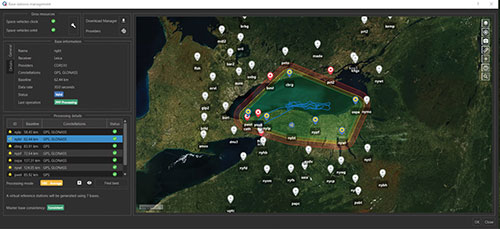
Screenshot: NV5 Geospatial
INSITE also enables users to import, search, analyze, manage, integrate and export all types of geospatial data and multimedia. According to NV5 Geospatial, as a cloud-based platform, INSITE improves speed and efficiency, minimizes storage expenses and supports greater collaboration by eliminating the use of standalone hard drives or a dedicated computer.
“Location-based data is critical for business and governments when it comes to managing risk, lowering costs, forecasting work and maintaining compliance,” said Mark Abatto, president and COO of NV5 Geospatial. “Yet there are numerous technical and organizational barriers that prevent them from optimizing use of this information. INSITE was purpose-built to break down these barriers, creating a single source of truth for all geospatial data within an organization. Now, with INSITE, distributed teams can collaborate more effectively, visualize data with ease and gain real-time insights through powerful analytics.”
According to the company, the INSITE platform is the foundation of three primary categories of use: the INSITE Lifecycle, INSITE Core, and INSITE Facility and Pole Manager.INSITE Lifecycle provides visibility into project status through a web-based map with real-time tracking of data from acquisition through processing and delivery, while INSITE Core enables data visualization and interaction, including access to aerial imagery, lidar data, GIS layers, and more. Lastly, INSITE provides the basis for industry-specific applications, including INSITE Facility and INSITE Pole Manager. INSITE Facility provides configurable asset management, including planning, execution and tracking for inspections and maintenance on any asset and facility, and INSITE Pole Manager enables electric utilities to take advantage of automated pole modeling analytics that support joint use, clearance and integrity analysis programs.
NV5 Geospatial will host a live launch webinar on Feb. 18 to provide an overview of INSITE. Register for the webinar here.
A roundup of recent products in the GNSS and inertial positioning industry from the January 2021 issue of GPS World magazine.
OEM
Receiver board
Enhanced with corrections
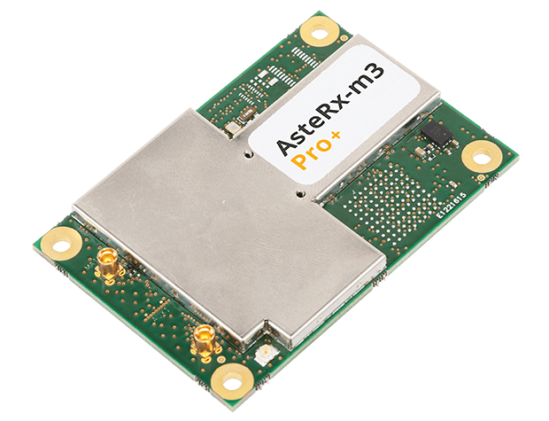
Photo: Septentrio
The AsteRx-m3 Sx OEM board dual-antenna receiver combines Septentrio’s latest core GNSS technology with the SECORX-S sub-decimeter correction service to enable plug-and-play positioning. High-accuracy positioning is available directly out of the box, GNSS corrections automatically streamed to the receiver. This significantly simplifies the set-up process and eliminates the need for corrections service subscription and maintenance. Corrections are delivered via internet or L-band satellites, ensuring sub-decimeter service even in remote locations where there is no easy internet access.
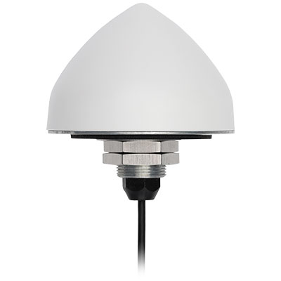
The new TW5382 smart GNSS antenna is designed for high-accuracy 5G timing. The TW5382 is a multi-band, multi-constellation 5G smart GNSS antenna/receiver that provides 5 ns (1-sigma, clear sky view) timing accuracy. It consists of two components: a Tallysman GNSS Accutenna technology antenna and a professional-grade GNSS timing receiver module. Accutenna supports the full bandwidth of the TW5382 receiver, strong multipath mitigation and deep filtering in a compact IP69K enclosure. These features enable the antenna to provide a strong, pure, in-band, right-hand circular polarized signal to the receiver. The TW5382’s professional-grade multi-constellation and multi-signal timing receiver tracks GPS/QZSS (L1/L2), GLONASS (G1/G2), Galileo (E1/E5b), and BeiDou (B1/B2) signals.
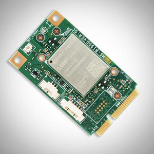
The new Precision GNSS Module (PGM) is designed to offer fast evaluation and a quick path to production for those requiring a precise positioning solution. It is available in a simple-to-use, industry-standard mPCIe (mini peripheral component interconnect express) format and is designed specifically for Swift’s Starling positioning engine running on a host application processor to deliver real-time precision navigation. The PGM utilizes STMicroelectronics’ TeseoV chipset in Quectel’s multi-constellation, dual-band LG69T-AP receiver to create an affordable, easy-to-use solution for customers building industrial, last-mile and internet of things (IoT) platforms. This solution operates with the highest accuracy when used with Swift’s Skylark positioning service.
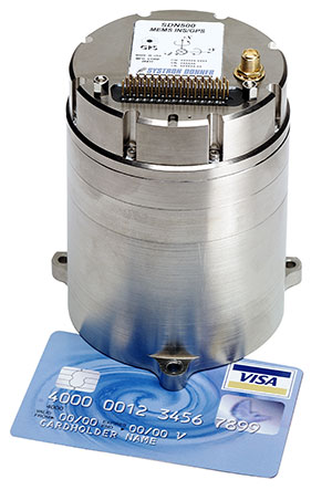
CAST Navigation tested Emcore’s SDN500 inertial navigation system (INS) in an ultra-high-altitude flight simulation and achieved success. The test required simulating performance at an altitude of more than 24,000 meters and velocities over 600 m/s. Only a few aircraft in the world have such capabilities, including the SR-71 Blackbird, but it is not practical to participate in a test flight on the SR-71. Simulating the SDN500 INS test flight to specific customer profiles on a CAST system is straightforward and cost-effective. Emcore relies on GNSS/INS simulators for hardware-in-the-loop testing to verify the expected performance of algorithms. Emcore sought to validate the velocity and altitude limits of a new GNSS receiver along with the algorithm performance in a tactical-grade SDN500 system.
The Dimensity 700 5G smartphone chipset is a system on chip (SoC) designed to bring advanced 5G capabilities and experiences to the mass market. MediaTek’s Dimensity family of 5G chips is designed to give device makers a suite of options for 5G smartphone models. The chips range from flagship and premium to mid-range and mass market devices to make 5G more accessible for consumers everywhere. GNSS signals received include GPS L1CA and L5, BeiDou B1I and B2, GLONASS L1OF, Galileo E1 and E5, QZSS L1C and L5, and NavIC.
IHawk allows users to inspect sites remotely and then download and view the analysis anywhere in the world. It eliminates the need for engineers to climb towers for inspections or work in hazardous environments. The imagery and information gathered provides a detailed and highly accurate analysis of the condition of power transmission towers.
The Alpin UAS is a long-range, heavy-lift unmanned helicopter capable of carrying up to 160 kg with a range of up to 840 km. The UAS includes a wideband satellite communication channel from its command-and-control station — a valuable feature, particularly for operations in remote areas. The Alpin unmanned helicopter is able to withstand severe weather conditions, carry multiple payloads, and transmit real-time information to defense forces and decision-makers in the field. Its system autopilot has features and advantages such as fully autonomous take-off and landing, remote ground-control network capability, auto-rotation landing capability and high efficiency flight control based on a total energy control system (TECS).
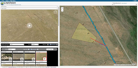
LineVision Online now provides enhanced support for visualizing and mapping DJI drone video camera metadata and field-of-view projections. The secure web application is designed for immersive mapping, analysis, search, sharing and archive of geo-referenced videos, full-motion video, photos and other survey, inspection and surveillance datasets. With enhanced camera metadata mapping in LineVision Online, DJI drone videos can now display a dynamic, field-of-view outline representing where the gimbal camera was looking on the Earth as the video plays in the web-based map interface. Users can select any point along the UAV’s flight track on the map to immediately cue the video to play what was recorded at that location click point.
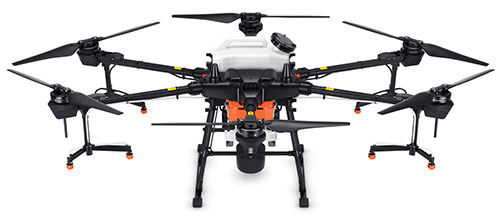
The Agras T20 drone can conduct autonomous operations over a variety of terrains, such as broad-acre farmlands, terraces and orchards. As a comprehensive spraying system, the T20 allows users to easily set flight and operation parameters. With a built-in real-time kinematic (RTK) centimeter-level positioning system and RTK dongles, centimeter-level waypoint recording is enabled, strengthening operations and ensuring precision spraying.The T20 is equipped with eight nozzles and high-volume pumps that can spray at a rate of up to 6 liters per minute. A highly optimized wind field produces droplets of the correct size and consistency. The T20 is also equipped with a new four-channel electromagnetic flow meter, which monitors and controls four hoses individually, ensuring an efficient flow rate for each nozzle.
A new virtual base station (VBS) feature is available in Qinertia, GNSS and inertial navigation system (INS) post-processing software. Trajectory and orientation are greatly improved by processing inertial data and raw GNSS observables in forward and backward directions. The VBS computes a virtual network around a project in which position accuracy is maximized, homogeneous and robust, such as a PPK short baseline. Once surveyors collect data, Qinertia chooses the most relevant reference stations, builds a virtual network and brings the project to centimeter-level accuracy with no convergence effects, even in urban areas.
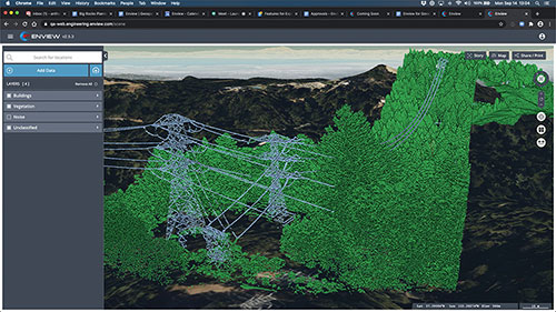
Enview Explore is a powerful web application that leverages artificial intelligence and cloud computing to automatically process 3D data at a high speed and scale. Enview performs a variety of geospatial operations, including object recognition, feature extraction, feature-based change detection, and 2D/3D measurement. Enview’s technology has been deployed on thousands of square miles worldwide to protect vital infrastructure and support mission-critical operations. Its unique method for classifying 3D data reduces time to action by focusing on finding meaningful insights.
PDGrade — a machine guidance and positioning system that uses GNSS for pile driving applications — is now optimized for the solar industry with an increased capability in pile installation and navigation accuracy. It removes the need for surveying piles and reviewing as-built information by centralizing all relevant information and providing necessary details to operators and site supervisors.The system features both software and hardware applications to provide operators with detailed information such as pile navigation, pile location, positioning and height information, project progression tracking, and detailed accuracy. The PD machine is fitted with Carlson sensors and a ruggedized Windows-based MC10 tablet. The entire system is then calibrated within PDGrade.
TCarta Marine has introduced a Global Satellite Derived Bathymetry (G-SDB) product line developed with a new seafloor depth measurement technique that leverages Machine Learning and NASA ICESat-2 laser data. According to the company, this G-SDB offering covers the entire Red Sea, with additional sets rolled out through the end of this year.
The commercial TCarta G-SDB data sets and the seafloor measurement workflow that produces them were made possible through a Small Business Innovation Research Grant from the National Science Foundation (NSF).
According to TCarta, G-SDB data sets contain bathymetric measurements to depths of more than 30 meters, depending on water clarity, at 10-meter resolution. The depth values for every 10-meter pixel are the combined result of numerous measurements, resulting in accuracy within 10% of depth or less, and providing a seamless water bottom surface map. G-SDB will be available globally for all oceans and seas, as well as large freshwater lakes where water conditions permit.
“The new satellite-derived bathymetry technology extracts seafloor measurements by integrating multiple SDB algorithms and sensor types at scale and over broad geographic areas with a degree of confidence in data accuracy not previously possible,” said TCarta president Kyle Goodrich.
TCarta launched Project Trident with NSF funding in 2018 with the goal of refining traditional satellite-derived bathymetry technology to extend its application into areas where it had not typically been successful, usually due to the turbidity or clarity of the water column. TCarta developed the new method using machine learning to iteratively evaluate Sentinel 2A/B multispectral satellite images, and even individual pixels within images, to select the sharpest and clearest ones for application of SDB extraction.
“Thanks to the power and speed of cloud computing, we run the extraction algorithm repeatedly and on multiple satellite images acquired over the same geographic area on different dates. This dramatically increased the accuracy confidence in each depth measurement and minimizes data gaps,” Goodrich said.
To further enhance the accuracy of the SDB measurements, TCarta developed an artificial intelligence-based technique for leveraging ICESat-2 data to train the SDB algorithm and validate results. Designed for polar ice elevation and tree canopy measurements, the ICESat-2 satellite carries a laser that captures remarkably accurate bathymetric data, the company said.
TCarta Marine is a global provider of hydrospatial solutions. The TCarta product lines include high-resolution satellite-derived water depth and seafloor map products as well as 90- and 30-meter GIS-ready bathymetric data aggregated from numerous information sources.
Golden Software has improved visualization and other functionality in the new version of its Surfer gridding, contouring and 3D surface mapping package. Surfer users now have a greater number of options for displaying their scientific data in the new version, the company said.
Surfer enables users to model data sets, apply an array of advanced analytics tools and graphically communicate the results in ways anyone can understand, Golden Software added.
“In the new Surfer release, we worked on making it easier for users to gain insights into their data sets by providing additional visualization tools,” said Kari Dickenson, Surfer product manager. “New display options also enable users to more easily communicate the information extracted from their data.”
The updated Surfer
In its latest version of Surfer, Golden Software has added the peaks and depressions layer type. This layer type automatically identifies and outlines closed high and low areas, or peaks and depressions, in a grid file. In addition, a statistics report is generated for the areas, including information such as length, width, depth, volume and orientation. The feature also allows high and low areas to be colorized, annotated and displayed on their own.
The company also added four new capabilities to 3D Views: color scale bars can be added to explain the elevation, concentration or other data values depicted by colors; VRML file format exporting enables users to export their 3D Surfer model into another 3D software package or to a 3D printer; anti-aliasing makes axes and grid lines inside the 3D model appear smoother and more professional; and improved 3D PDF exporting has reduced the PDF file size and made the file exporting process faster.
In addition, Golden Software added several existing capabilities to the automation function so that users can write scripts to automate certain workflows. Automated features now include base from data layer type, vector base map symbology, new scale bar options, new legend options and new grid data options. Finally, the new Surfer version allows users to identify objects in vector base maps, such as polygons, polylines or points, by automatically renaming them based on any attribute, as well as select multiple polygons and choose to calculate their statistics, areas or volumes either as a single combined polygon or as individual polygons.
Surfer Beta
Golden Software released a Beta version of Surfer simultaneously with the new version to give customers a chance to try out new features while they are still in development. The three features the company plans to release for the spring/summer 2021 release of Surfer include 3D base maps, contour volume/area calculation and more automated features.
The 3D base maps feature allows .DXF, .SHP and other file formats to be imported with their 3D geometry (3D polylines, polygons and polymeshes) and displayed as three-dimensional features in the 3D View.
A new shortcut also will enable users to calculate volumes and areas above, below or between contour lines with just a few clicks of the mouse, the company said. Finally, additional functions that have been added to automation include point sample, grid project, new classed post layer options and label options for the degrees-minutes-seconds label format.
Golden Software, headquartered in Golden, Colorado, develops 2D and 3D scientific modeling packages.
We leave as we came, and, God willing, we shall return, with peace and hope for all mankind.” —Astronaut Gene Cernan’s closing words, the twelfth and last person on the moon as he stepped back into the Apollo XVII Lunar Module on December 13, 1972.
Photo: NASA
Apollo was about vision, courage and discovery. Apollo helped unravel the mysteries of the moon — a serene, desolate, and barren place, bleached by the sun, and covered in a pale, gray, abrasive dust made up of microscopic, razor sharp, glass-like shards called regolith that is 60 feet deep in places.
Beneath the regolith is the bedrock of the moon — the Lunafirma.
The next phase of exploration is building a permanent base station on the moon, aptly named Artemis, Apollo’s twin sister. It would be fitting when mankind returns that the next person who steps out onto the lunar surface were a woman.
Artemis Moon Log/Program Entry Date 42: Earth Day is Tuesday, November 4, 2025
The regolith mining operations are proceeding as expected. All operations are 100% solar power until additional mobile thorium reactor units arrive. The only existing thorium reactor unit is the Clavius Crater water extraction operation. Construction of the Selene-1 Moonbase has encountered a setback. No other issues are reported.
The regolith in the surrounding plain is 6 meters deep. The Miners have not experienced any issues. The electrostatic power suits are repelling the abrasive dust better than expected. The Miners have cleared a 50 m2 area down to the bedrock. From the Gateway observation deck, it appears as a small square crater. The Miners are working non-stop on rotating shifts clearing regolith, recharging, replacing parts, or in transit.
Analysis of the regolith reveals a uniform distribution of 21% silica, 13% aluminum, 10% calcium, 10% iron, 5% magnesium, and 2% sodium and titanium. Minor amounts of chromium, phosphorus, and potassium are present. Hydrogen is 0.0027%. The metals are all oxides containing 40% elemental oxygen, which is being separated during processing for later use.
West about 200 km, towards Mare Crisium, the gravitational anomalies increase but within the Selene-1 Moonbase crater the anomalies are negligible. Geospatial analysis of the drill cores show an extensive concentration of lithium beneath a 12-meter-thick layer of basalt east of Ginzel Crater. Towards the south are increased concentrations of titanium and tungsten. Ejection debris discovered during the regolith mining operation showed traces of neodymium. The estimated trajectory of the ejecta points to it coming from the Moiseev Crater complex. An expeditionary rover is in route to collect samples and will arrive in 6 hours. Readings from those samples will be in the next log report.
The Parabolic Solar Powered (PSP) laser torches in the open crater basin are performing as expected. The Constructors are 3D fusing the regolith into silicate glass forms and transporting them to staging areas for later construction. The higher-than-normal content of iron in the regolith is giving the glass forms a reddish hue.
At the south pole, the water extraction operation at Clavius Crater has been operating uninterrupted for 816 hours. The thorium reactor is powering the entire operation. The smelter is distilling volatiles out of the regolith at the rate of 1m3 every 8 hours extracting a liter of water every 24 hours. The operation is on schedule for the two 100-liter tanks of water for delivery to the Selene-1 Moonbase by the due date.
There are five 4G cellular towers around the perimeter of the Selene-1 Moonbase and regolith mining area at 3 km intervals. The cellular array is providing accuracies of 1 millimeter allowing for precision mining, drilling, construction, and transportation. As the operation expands, more towers will be added. Two more towers are stationed at Clavius Crater. The 360° cameras and radar provide continuous surveillance and monitoring.
Testing of the 3D vision and synthetic neural response systems of the robots is complete and all of them are operational. The real-time connectivity with the robots allows controllers onboard the Gateway to remote link into any of the robots using virtual headsets and haptic body suits for full-immersion control. AI is constantly scanning for anything unusual and alerts the controllers to remote in; otherwise, the robots operate continuously and efficiently. The Miners are clearing nearly 5m3 of regolith every 24 hours during light conditions.
Phase I is underway. Miners are leveling off the exposed bedrock to begin construction of the landing pad. Once finished, the Constructors will use the PSP laser torches to begin fusing together the silicate glass blocks to make the landing pad. Afterwards, The Miners will begin Phase II and lay the foundation for the railgun to propel the filled mineral containers back to Earth. Both Phase I and Phase II are on schedule.
The setback encountered during construction of the Selene-1 main base station is due to excessive heat build-up. The Excavators are clearing the floors and shaping the walls within the lava tube. However, the heat from the laser torches is building-up and shutting down the machines prematurely. When the ambient temperatures exceed 160°C the machines shutdown to protect their electrostatic coatings. Having no atmosphere and no wind the heat is not dissipating. The fluid in the heat exchangers is overheating. Until directed otherwise, the Excavators are doing 90-minute shifts and the Torches for 35 minutes. The Torches have to fuse together the support beams and the silicate glass protective layering behind the Excavators to preserve structural integrity. A software update set the laser torches to pulse fire extending the heat build-up for an additional 5 minutes. Only 15 meters have been cleared but the inflatable habitats require at least another 85 meters into the lava tube. The setback pushes back the date for completing the base station by approximately 620 hours. A temporary external module can house the astronauts for their return on April 19, 2026 until Selene-1 is completed.
The above fictional account of a Moon Log entry for the Artemis program is based on NASA’s mid-October announcement selecting Nokia to build a 4G network on the moon.
An in-depth look at the announcement holds interest for the GIS community.
The Artemis program will be heavily dependent on spatial technologies and require a Lunar Spatial Reference System. However, the Moon has significant challenges. There is no constellation of satellites orbiting the Moon to provide precise location data like GPS satellites do on Earth, and it is not possible to develop such a satellite system around the moon because the moon’s gravitational center is lopsided and weighted towards Earth due to tidal lock. This causes orbital decay of lunar satellites until they eventually crash into the lunar surface.
However, there are four orbital inclinations that allow for indefinite low orbits and may provide for a future Lunar Positioning System (LPS). Such a system would be extremely costly, so a less expensive and more immediate LPS will be a ground-based cellular network array; and 4G is preferred over 5G because it offers longer ranges, which is why NASA selected Nokia. NASA is working on other solutions through the Space Communications and Navigation (SCaN) program.
Figure 2: Unified Geologic Map of the Moon. Orthographic projections of the “Unified Geologic Map of the Moon” showing the geology of the Moon’s near side (left) and far side (right) with shaded topography from the Lunar Orbiter Laser Altimeter. It will serve as a reference for lunar science and future human missions to the moon. Gravitational mass concentrations are also depicted in the image showing the majority being on the nearside while the farside is void of gravitational concentrations. Check out a video of rotating sphere. (Image: NASA/GSFC/USGS)
In a blow to science fiction novels, it will not be humans out on the barren, dust covered lunar landscape, or in the cold depths of crater shadows with pickaxes and jackhammers. It will be robots working prolonged periods in extreme temperatures running on solar power or nuclear power while constantly bombarded by cosmic rays and direct solar radiation.
Accomplishing this will require real-time communication with spatially enabled, artificially intelligent machines able to support fully immersive experiences with 3D vision headsets and haptic feedback systems so controllers at the base station wearing special suits can remote into any robot.
Due to a 2.5-second transmission delay between the Earth and the Moon, Ground Control will be limited to observation and analysis. Autonomous rockets will ferry cargo and supplies between more distant locations on the moon and ferry astronauts back and forth to the Gateway space station.
The ground-based 4G cellular towers will be mobile units with retractable towers about 25 meters high with a circular array of solar panels that will unfurl about 10 meters up from the base of the mast to protect them from the abrasive regolith dust.
Beneath the panels rovers and robots will plug in and charge their batteries as they journey to and from the base station. The towers will have 360° cameras and sensors and will provide data links and a localized spatial reference system.
However, objects in flight, such as autonomous rockets, will require other means to navigate across the moon and between the space-based cargo ships and the base station.
One solution is visual-inertial odometry (VIO). It uses one or more cameras and at least one inertial measuring device. Those components are already standard on almost every smartphone. Position accuracy using VIO is derived by feature recognition — the most prominent features on the moon are craters.
In support of this initiative, the National Geospatial Intelligence Agency (NGA) is sponsoring a software developer’s challenge to create algorithms for identifying circular patterns in imagery. It’s harder than you think. Learn more here.
Figure 3. (Photo: NASA/GSFC/Arizona State University)
The base station will be inside a lava tube beneath the moon’s surface to protect astronauts and equipment from solar radiation and micrometeor impacts. Most of the resources for the moon base will be extracted and processed in-situ, which requires spatial analysis of drill core samples to pinpoint where to mine for minerals in the subsurface layers and where to locate scarce resources such as water. The lava tubes on the moon are also valuable for mining operations but navigating an underground environment with autonomous machines poses challenges of its own, some of which are spatial awareness. The Defense Advanced Research Projects Agency (DARPA) recently held a developer’s challenge to address navigating in subterranean domains.
“Reaching the Moon by three-man vessels in one long bound from Earth is like casting a thin thread across space. The main effort, in the coming decades, will be to strengthen this thread; to make it a cord, a cable, and, finally, a broad highway.” —Isaac Asimov
William Tewelow works for the Federal Aviation Administration. He is a graduate of the FAA management fellowship program. He served on special assignment to the U.S. Department of Transportation leading a national strategic geospatial iniative for the White House Open Data Partnership. He is a Geographic Information Systems Professional and a speaker for the Maryland STEMnet Scholar program. He was among the first in the nation to earn a Geospatial Specialist Certification from the U.S. Department of Labor while working at NASA Stennis Space Center. He has degrees in Geographic Information Technology, Intelligence Studies and is completing a masters degree in Organizational Management. William is a 23-year veteran for the U.S. Navy serving as a geospatial specialist, imagery intelligence specialist, a naval aviator, a meteorologist and a tactical oceanographer. He is married, enjoys writing and traveling. His favorite quote is, “A man’s mind changed by a new idea can never go back to its original dimension.” —Oliver Wendell Holmes