Terrain Painting in Global Mapper v22. (Image: Blue Marble)
Blue Marble Geographics has released version 22 of Global Mapper along with an upgrade to the accompanying Lidar Module.
Global Mapper GIS software provides both novice and experienced geospatial professionals with a comprehensive array of spatial data processing tools, with access to a variety of data formats.
Among other features, Version 22 includes
Eye Dome Lighting settings in the 3D viewer to help improve the visual display of vector and lidar data
a new tool for simplifying meshes or TINs
a new Spatial Operations tool for analyzing the relationship between overlapping vector features
a new option to measure the overlap between two or more lidar, raster/image and terrain layers
a new consolidated Digitizer Menu providing convenient access to all drawing and digitizing tools
The Lidar Module, an optional add-on to Global Mapper, provides advanced point cloud processing tools, including Pixels to Points for photogrammetric point cloud creation using overlapping drone-captured images, automatic and manual point cloud classification, feature extraction, hydro-flattening, and more.
Terrain Paint tool. The upgraded Lidar Module includes a new Terrain Paint tool for manipulating elevation values in a freeform way, a new algorithm to improve building classification results, improved building extraction with better 3D shape simplification for generating building footprints, a new option to create a process summary report when using the Pixels to Points process, dramatically faster rendering of lidar path profiles with a large number of points, and more.
“The version 22 release illustrates Global Mapper’s rapidly expanding geospatial footprint,” stated Blue Marble’s President, Patrick Cunningham. “In this one release cycle, we have introduced countless new tools for GIS analysis.Global Mapper is truly an accessible yet powerful GIS platform. As always, we are pleased to be able to bring all of these capabilities together in one GIS platform while keeping the price affordable.”
Blue Marble Application Specialists will hold a webinar Sept. 30 to showcase Global Mapper v22. This presentation is scheduled to begin at 2:00 pm (U.S. Eastern Time), and it will allow attendees to see the latest tools and ask questions about the new functionality. Registration is required.
London building-design agency DCSK is using 3D building models from Bluesky to inform the design of high-profile urban residential developments.
Derived from the most up-to-date and accurate aerial photography, the Bluesky 3D models allow DCSK to place a design within its real-world context, consider sensitive view and vantage points, and communicate ideas to clients, planning authorities and the public.
DCSK has used a number of models from Bluesky, including a detailed representation of central Birmingham for the design of a 24-storey student accommodation on Lancaster Street.
“We have always had to consider how a design sits within the existing cityscape and how it will interact with the buildings and infrastructure that surround it,” said James Khamsi, Director of DCSK. “Before geographically accurate computer representations, such as the Bluesky 3D models, were available and affordable, we relied on a combination of site photographs and traditional 2D maps. This was a crude workflow that raised potential concerns about the currency and accuracy of information that was informing both the design and resulting planning permissions.”
DCSK is using 3D models from Bluesky for projects such as Curzon Circle Student Accommodation and others.Photogrammetrically derived from stereoscopic aerial photography, the Bluesky models are fully rendered and are provided as either wireframe or block models in a format suitable for use in both CAD and GIS software.
All Bluesky 3D models are supplied with a digital terrain model (DTM) depicting the topography of the underlying surface.
DCSK imports the Bluesky data into its 3D modelling software Rhino, where it is used to create a background layer for the design. The development site is isolated, and this data removed from the background layer, allowing for the detailed design to be dropped in. The proposed development can then be viewed and analyzed in its real-world context with detailed assessments of access ways and viewpoints, for example.
“The Bluesky models allow us to inhabit the site and experience the design as if we were there,” said Khamsi. “We can explore potential sensitivities, and, as the models are agile, we can massage the design exploring different options without leaving the office. The Bluesky models are also intuitive and therefore easy to interpret allowing us to communicate complex design ideas.”
Mobile GIS Services (MGISS) has been awarded a place on the United Kingdom government’s procurement platform G-Cloud.
Designed to ease the procurement of cloud services by the public sector, the G-Cloud 12 framework makes it easier for customers to find, review and contract MGISS’s advanced geospatial software services through an online digital marketplace. Managed by Crown Commercial Services, it is forecast that successful suppliers, such as MGISS, will receive up to £2 billion in business.
In a parallel achievement, MGISS has also been accredited as a supplier of software, hardware and support services to the utility sector by the supplier assurance company Achilles.
A specialist in mapping and geographic information technology, MGISS also is working alongside organizations such as United Utilities and Northumbrian Water Group and it is hoped that successful qualification under the Achilles UVDB pre-qualification system will help MGISS gain further traction within this sector.
MGISS has also attained the Workplace Wellbeing Charter. Recognizing a commitment to improving the lives of its team members, MGISS received accreditation across a number of facets including leadership, health and safety, mental health and absence management.
“Although recognizing completely different aspects of the business these awards are all significant milestones and accomplishments in their own right and the entire team should be proud of the hard work and commitment they have expended to achieve them,” said MGISS Managing Director and Founder Mike Darracott. “The G-Cloud and Achilles accreditation will put MGISS front and center for the leading players within the public and utility sectors and this will help us capitalise on our work to date with organizations such as Surrey County Council and Wales and West Utilities.
“The Workplace Wellbeing Charter not only recognizes our existing commitment to the health and wellbeing of our team it also gives a benchmark to work from and a toolset to work with to continuously improve,” he continued, “and a happier and healthier workforce will, we hope, make the business even better and stronger.”
Firm will provide geophysical surveying services across multiple states
Dewberry, a privately held professional services firm, has been awarded multiple task orders from the U.S. Geological Survey (USGS) under the Geospatial Products and Services Contract (GPSC) to perform airborne geophysical surveys in portions of Missouri, Illinois, Kentucky, Texas and New Mexico for the USGS Earth Mapping Resources Initiative (Earth MRI).
“Earth MRI is a play on words, as people are familiar with the use of magnetic resonance imaging (MRI) to image inside the human brain,” said Dewberry Project Manager David Maune. “Dewberry is excited to support USGS in its mission to assess critical minerals using airborne geophysical survey technology.”
Dewberry will perform very low-altitude magnetic and radiometric surveys from a fixed-wing aircraft and a helicopter with towed-array sensors to image subsurface geologic structures in search of undiscovered critical minerals and rare earth elements vital for the electronics industry.
These projects, which will be used to evaluate the potential for undiscovered critical mineral deposits contributing to an understanding of the major mineral systems for the two regions, are expected to be completed in early 2021.
With advantages provided by geographic information systems (GIS), the demand for GIS in the telecom industry has increased in recent years. According to a report published by Allied Market Research, the global telecom market is anticipated to garner $3.27 million by 2023.
GIS has fortified the telecom industry by reducing costs and augmenting capital planning. GIS mapping can improve outage prediction, resource management and infrastructure determination.
GIS also can help the emerging economies for independent energy, efficient infrastructure, and enhanced communication systems. GIS provides imagery, geocoding, modeling, routing and the required data for these applications.
GIS is rising in popularity as it eases access to critical sources of business intelligence.
Impacts in the telecom industry
GIS mapping supports telecom companies with factors such as enhanced customer service with location data and imagery, efficient resource dispatch, and prompt sharing of location data. This enables telecom industries to track locations and have a better understanding of service layout.
GIS mapping lets companies know the geospatial relationships of their facilities, resources and ground features, and provide faster and more effective customer service.
GIS also helps identify faulty circuits. It can help model the solution online and offer best-case scenarios, resulting in improved operations and enhanced customer service.
GIS mapping also helps the sales and service team understand their targets by tracking multiple layers of geospatial data and providing insight into the customer base.
Information on network structure
Almost every telecom company focuses on offering effective, functioning networks, along with network monitoring, testing of network elements, maintenance and customer services. The real-time network structure offered by GIS solutions enhances these monitoring and service activities.
With GIS, networks get instant access to information such as customers’ history and rank, current network structure, signal quality in precise demography, and any need for maintenance or restoration of services. Moreover, GIS makes the services more reliable and fast.
GIS solutions are also beneficial for determining market demand for future estimations. GIS offers a better understanding of the relationship between customers’ topographical presence and companies’ marketing operations. It helps companies identify networking issues and easily reach customers, along with offering information on other issues.
With its precise geography, GIS helps telecom companies meet service demand and develop budgets for promotional activities and marketing campaigns.
Enhancing telecom services
With computers and mobile devices a necessity for most of us, many telecoms want to expand to provide services in rural areas — a major reason for their adoption of GIS.
Another motivator is the surge in demand for augmented reality and virtual reality, part of the increase in the adoption of GIS for mobile and broadband services.
Smart Cities. GIS provides a platform that works with Customer Relationship Management (CRM) systems, networks, databases, fault management system and wireless location. The demand for growth also depends on the rise in demand for satellite images by companies that provide maps and an increase in government spending to develop and build smart cities.
Moreover, the rising use of technology, the internet, and other digital platforms in rural areas has sparked companies to expand their services.
With companies focusing on broad network coverage, greater connectivity and emerging innovations such as 5G, the field of mobile telecommunications technology is anticipating opportunities to expand market growth.
Akshita Pacholi has a master’s degree in English literature and is working as a content writer with Allied Market Research.
Esri has released a new mapping app, Air Quality Aware, that fuses data from the EPA’s AirNow program, NOAA’s National Weather Service wind forecast and the American Community Survey to provide location intelligence on current air quality and its impacts on local communities.
At a national level, areas are color-coded according to EPA’s Air Quality Index, with magenta and purple representing hazardous and very unhealthy air quality.
As users zoom in, the map shows the air-quality scores reported at each individual air-quality monitoring station.
Users can click on any station for more information about the pollutants and concentrations reported at that location. They can also search for or click any place on the map to get more information about current and forecasts of air quality, wind speed and insights about the vulnerable population in each place.
Application empowers users with expert visualization and analysis of lidar
Enview, a pioneer in the scalable processing of 3D geospatial data, has launched Enview Explore, a powerful web application that leverages artificial intelligence (AI) and cloud computing to automatically process 3D data at a high speed and scale.
Also, Robert Cardillo, former director of the National Geospatial-Intelligence Agency (NGA), has joined the company’s board of directors. Following an oversubscribed round of funding in May, the company continues to experience growth and momentum in the market.
Enview’s technology has been deployed on thousands of square miles worldwide to protect vital infrastructure and support mission-critical operations. Its unique method for classifying 3D data using neural networks and deep learning techniques reduces time to action by focusing on finding meaningful insights in 3D data.
Previously offered as custom services for organizations such as Pacific Gas & Electric and the United States Air Force, this groundbreaking technology is now available for the first time as an easy-to-use, self-service web application.
Screenshot: Enview
“Enview has built the world’s most scalable AI platform for transforming 3D point clouds into insight and action,” said San Gunawardana, Ph.D., co-founder and CEO of Enview. “We are solving one of the hardest problems in machine perception, and applying it to some of the most grounded and impactful challenges facing society. It is our goal to empower people with the confidence to perceive and navigate a rapidly changing world; Enview Explore is the natural next step in this journey and our team is excited to place this groundbreaking capability directly into the hands of operational end-users.”
Key benefits of Enview Explore include:
The power of 3D data. Three-dimensional unstructured data, such as lidar, contains incredible detail but is painfully slow to analyze manually. Enview solves this problem by combining its novel AI with the power of cloud computing to automate 3D classification and segmentation, giving users scalability that can support even nation-sized datasets.
High speed. While current methods can take weeks or more to process data, Enview provides actionable insights in minutes. Enview Explore utilizes a new and innovative approach that applies AI to 3D data, yielding significantly faster results than traditional lidar software.
Total data control. Enview Explore removes the need for outsourcing lidar to a third party by giving users the ability to perform classification, segmentation, terrain modeling, change detection, feature extraction, and intuitive visualization directly inside the application.
Screenshot: Enview
“With this release, we wanted to show the world that you don’t need to be a professional to get expert analysis from lidar,” said Anthony Calamito, VP of Products for Enview. “Lidar and other 3D data hold tremendous value and provide unparalleled insight over 2D data sources. While unlocking that value traditionally has required an in-depth understanding of specialty software, Enview Explore lets anyone create meaningful insight from 3D data with just a few clicks.“
The company also announced that Robert Cardillo has joined its Board of Directors. Cardillo served as the sixth director of the NGA from 2014 through 2019. In that position, he led the NGA under the authorities of the secretary of defense and director of National Intelligence to transform the agency’s future value proposition through innovative partnerships with the growing commercial geospatial industry.
“Mapping the world in 3D opens new possibilities for national security and mission-critical infrastructure, including some of the most important challenges facing our nation today,” said Cardillo. “Enview has completely changed the game when it comes to what’s possible with lidar visualization and analysis, making unstructured data accessible and easy to use: in other words, creating coherence out of chaos. With a shared purpose and commitment, I look forward to working with the Enview team toward the future the world demands and our customers deserve.”
The Urban and Regional Information Systems Association (URISA) will be hosting GIS-Pro 2020, the association’s 58th Annual Conference, Sept. 29 to Oct. 2 in a virtual format. The event was originally scheduled to take place in Baltimore, but URISA chose to hold it virtually because of the COVID-19 pandemic.
“With the serious COVID-19 health and physical distancing concerns, hosting an in-person conference this year and putting members, presenters, and staff at risk was a non-starter,” the organization said.
Keynote speakers for the event include Martin O’Malley, the former governor of Maryland; Chris Vaughan, geographic information officer at the Federal Emergency Management Agency; and Juliana Blackwell, director of the National Geodetic Survey.
According to URISA, the program also will highlight a number of relevant topics, including public health, community resilience, equality and social justice, GIS leadership and ethics.
Here’s an overview of the program:
Wednesday, Sept. 23
• Best Practices for GIS Project Planning and Management
• NG911 & the GIS Workflow
• GIS in Emergency Management
• Microsoft Project Software Tutorial
Thursday, Sept. 24
• Experimental Learning Techniques to be More Effective
• Introduction to GIS for Equity and Social Justice
• Navigating a Virtual Landscape for your GIS Career
Tuesday, Oct. 6
• Building Community Using Geospatial Tools
• Unpacking the NENA NG911 GIS Data Model
• Changes Afoot After 2022: State Plane and the Death of the U.S. Survey Foot
Wednesday, Oct. 7
• Preparing for GISP Certification
• Coordinate Systems and Projections
Sessions also will be available on demand for GIS-Pro 2020 registrants after the conference, URISA said. Register for the event here.
Our ongoing battle with COVID-19 has shown we can adapt to radical changes. A big, but worthwhile, change would be to convert our existing land databases to a cadastre system.
Any place that one may travel around the globe, they will find boundary lines that define properties and regions. For some countries, these parcels may be primarily owned by the government while in more developed nations, a large percent of the land is owned by private citizens.
These parcels, when looked at together, together create a large jigsaw puzzle that seemingly fits together perfectly. Visually, all the lines should fit snugly to their adjacent neighbor so that the sum of the parts equals the whole. This system, called a cadastre, has many redeeming qualities and makes for an efficient choice of keeping an inventory of a region or country’s parcels and infrastructure.
Origins of the cadastre system
The cadastre system of parcel registration is the database of choice for determining land ownership and taxes on property through much of the developed world. Most of the places where this system of parcel registry consists of centralized governments usually have more oversight and legislative power than more “free” countries like the United States.
Also, these countries in which these systems exist are typically small and/or have a manageable number of parcels so the development of the cadastre is much more controlled and maintained.
To help us understand the origin of this parcel system, let us explore the background of cadastre and its beginnings:
Definition: an official register of the quantity, value, and ownership of real estate used in apportioning taxes Origin: Mid-19th century from French, from cadastre ‘register of property’, from Provençal cadastro, from Italian catastro (earlier catastico), from late Greek katastikhon ‘list, register’, from kata stikhon ‘line by line’. (Source: Merriam-Webster.com)
In the years after the fall of the Roman Empire and through the end of many feudal societies, land ownership was transferred to individuals and families with the expectation of paying a tax to the government for this opportunity. Landowners could plant and harvest their own crops, raise farm animals for labor, and provide various goods and services to the community.
Besides a small fee for conveyance, the government would ask for a “meager” tax to be paid regularly. Land that was sold to these individuals was recorded in a “cadastre” for tracking of ownership and tax payment. These records were primitive in nature and relied heavily on associating a parcel number to the owner versus an actual legal description to describe the property.
It was not until more sophisticated and elaborate surveying instruments were developed that physical descriptions of the land were used to determine boundaries.
Cadastre system gives way to legal descriptions
This cadastre system of parcel management continues to exist in modern times in many parts of the world with one notable exception: The United States. Some will equate our parcel indexing system as being a traditional cadastre, but this numbering procedure is secondary to the means and methods of parcel conveyance in the U.S.
For the non-surveyor reader, in the U.S. over the past few centuries a multitude of land systems have been used to establish parcel boundaries , each with their own unique system of describing land and conveyances. These types of land transactions began after the establishment of the colonial states and rapid expansion into previously unmapped territories.
The push westward across the country introduced the Public Land Survey System (originated by Thomas Jefferson) and established sectional land divisions. As we encountered (and acquired) new territories, including the Louisiana Purchase and Texas, existing land measuring units and description methods were maintained to preserve these systems. No matter how the parcels are described, we rely heavily on the grantor/grantee system of transfer of ownership and rights throughout most of the country, with parcel numbering being applied post-transaction.
So why is the grantor/grantee system the weak link in the chain of parcel establishment and conveyance? Many times, it comes down to the legal description and how it was created. Our system allows for the creation of a parcel by varying means by the professional land surveyor. The biggest issues occur when parcels are defined by a metes and bounds description with little to no reference to adjoining property or known monuments.
When the legal descriptions of these parcels come into play, that is when the trouble starts, with calls made to attorneys and surveyors to help straighten everything out. To the common layperson who owns land or is looking to buy a parcel, it may seem unthinkable that parcels do not naturally fit seamlessly together with no gaps or overlaps. While the quality of survey data has increased in precision, the accuracy of marrying old data with the new suffers in many ways. How did we get to this point? Let us step back in the not-so-distant past to review how things have progressed throughout my short career.
Set the flux capacitor to the early 1980s…
Before computers and CAD, most agencies adopted a system of parcel and right-of-way mapping manually drafted on large sheets of durable paper or film. Depending on the municipality or county one was in, each sheet could represent either a quarter section (approximately 160 acres) or one half of a quarter section (approximately 80 acres) within a standard section of the Public Land Survey System (PLSS) established by the General Land Office (GLO) of the U.S. (now known as the Bureau of Land Management).
These maps were based upon standard measurements within the given quarter section and drawn using 90-degree corners at the edges of the sheet. The linework depicting the parcels within blocks and larger areas was drawn as close to scale as possible but was intended to be a graphic representation of the shape rather than an accurate reproduction. Considering the technology and measuring devices/capabilities of the time, these records were very helpful in performing retracement surveys of existing properties.
Because these surveys and parcel recordkeeping were performed long before computers, plotters, and CAD software became the norm, surveyors calculated and documented their work using manual computation and drafting from handwritten notes collected in the field. Not every parcel has 90-degree corners and lengths that are integers, so mapping departments for governmental agencies drafted new surveys and parcel boundaries to fit within the existing base sheets. Throw in the varying measurements from different surveyors and we have the real-life jigsaw puzzle that does not fit.
Because the aforesaid mapping departments produced parcel numbering after the creation and conveyance of the property, the damage is already done in conforming with adjacent properties. This is an important factor in the professional surveyor’s responsibility to protect the public when performing an original survey for a new parcel and/or subdivision and utmost care must be observed.
We have an army of land surveyors across the country shaping parcels to fit within a large jigsaw puzzle with an instruction sheet that must be strictly followed. One missed measurement or corner monument is in the wrong position, and we now have two or more parcels that will not fit together in the puzzle.
Many mapping professionals will point, however, to the geographical information system (GIS) and how it improved this convoluted method of parcel databases. But did it?
The digital spaghetti bowl
For a large part of the U.S. where a data-intensive GIS has been created and maintained, it is a step in the right direction, but it still lacks the overall efficiency of a cadastre. Very few GIS databases contain survey-grade parcel establishment on recognized horizontal and vertical datums. Most are parcels and roadways digitized from old mapping and records that are vague graphical representations at best.
One of the most important pieces of the GIS database are the base layers that contain control points and parcel/right-of-way lines that coincide with the datums that govern the region or state. Many governmental agencies do not employ a professional surveyor or surveying staff educated and trained to establish these datums within the database.
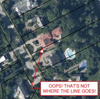
Incorrect GIS parcels information. (Image: Tim Burch)
Most times, the base layers are established “close enough” using aerial mapping and other data, including handheld GNSS receivers to collect infrastructure improvements. This is not a knock on these departments or individuals; they created the best possible database with the information on hand.
When merged with aerial mapping and/or survey-grade data, the graphical information from the archival records can be confusing and misleading, especially to those who are not educated to understand the data.
Is the cadastre an upgrade?
The reason to consider converting all the existing parcel mapping and subsequent infrastructure/improvement mapping to a cadastre are simple: technology. We have previously discussed cities building digital twins (“Surveying and Geospatial Data,” GPS World, July 2020) utilizing remote sensing and a multitude of GNSS-capable products.
Besides surveyors, many professions and trades use GNSS technology as a tool within their work environments. Our nation has experienced rapid growth in the last 150 years. The Industrial Revolution and the advancement of machinery, materials and building techniques have greatly impacted the ability to build more infrastructure and improvements. Many of these improvements and utilities have exceeded their useful life but have no timelines for replacement.
Developing accurate maps of this aging infrastructure will ensure a proper data set from which a replacement design can be made. Couple this ability to work in a geospatial environment with other datasets, including aerial/satellite photography and lidar acquisition, and it gives us a nearly unlimited ability to map our world in appropriate datums with greater accuracy and precision. Governmental agencies could utilize this system to monitor illegal activities (such as dumping, mining, unpermitted construction) and gauge environmental concerns (drainage issues, problematic runoff, deteriorating infrastructure) to better protect the public. This system could also be used to refine our property tax system and work towards a more equitable means of assessing our properties.
None of these potential changes and upgrades would have been possible 40-50 years ago; the invention and adaptation of GNSS have allowed these technologies to emerge. We continue to find new ways of measuring and mapping, so using these new techniques should be foremost on our minds to make these previous tedious tasks much easier to accomplish.
The hurdles to change
The biggest challenge, in my professional surveying opinion, will be adapting millions of parcels and deeds to a new database and applying them to the current datums. For instance, here is an example of potential (and recordable!) legal description:
“Beginning at the northeast corner of the parcel, said corner being the intersection of the south right-of-way line of Smith Street with the east right-of-way line of Jones Street; thence easterly on the said south line of Smith Street to the northwest corner of the Williams parcel per Deed No. 12345; thence southerly on the west line of said Williams parcel to the north right-of-way line of Main Street; thence westerly on the said north line of Main Street to the intersection with the said east right-of-way line of Jones Street; thence north on the said east right-of-way line of Jones Street to the point of beginning.”
Example of “bounds” legal description. (Image: Tim Burch)
While this is only a made-up example, it does represent a generally accepted legal description for parcel conveyance in most recording agencies. What does a mapping department do with this kind of legal description to place it accurately within a GIS or cadastre? Unless the four adjoining legal entities (Smith Street, Jones Street, Main Street, and the Williams parcel) exist geospatially within the database, the technician will have a tough time inserting this parcel into the records. Unless the entire surveying community is up to the challenge of working solely in an approved geospatial datum for all their work, much of this effort will not accomplish anything.
The other roadblock to converting our current systems to a cadastre is the rest of the parties who work with legal documents, plats, and infrastructure; they may not be up to the challenge for making a radical change for the better. From the assessor’s, recorder’s, and mapping offices to the title companies and attorneys, many have an attitude that the system is too big to revamp. Because they only work in one part of the overall system, they do not see the benefit of blowing it all up to make it a more robust and useful database.
Practically speaking…
Revamping of any system within the varying levels of government is costly, no matter what branch or region is discussed. Governmental agencies are being asked every day to do more with less and provide more value in their services with few numbers of staff.
While there may be a large upside to converting our existing databases to a cadastre, the downside is the effort and cost to do so. Yes, the new system would be scalable and easily adaptable for more infrastructure growth and could be expanded in an infinite number of ways. We can liken this proposed idea to converting all weights and measures to the Metric System: going metric will make lots of tasks and procedures easier, but flies in the face of everything we know as a society.
However, our ongoing battle with COVID-19 has shown we can adapt to radical changes. The cadastre is a better system, but I do not want another worldwide disaster to convince us to change.
Advancements in sensors, cameras and automation have fueled the growth of the aerial imaging industry, which is expected to reach $2.83 billion by 2022.
By Swamini Kulkarni
Unmanned aerial vehicles (UAV), or drones, often gain the spotlight with to their ability to capture the view from a vantage point. For years, airborne cameras have clicked never-seen-before pictures across planet. Now imaging technology is utilized to monitor natural calamities and borders of countries.
Drones have been quickly adopted in various industries including surveillance, geospatial mapping, post-disaster monitoring, and even entertainment. The advancements in sensors, cameras and automation have fueled growth of the aerial imaging industry.
Cameras mounted on balloons, kites and now drones are used widely across various verticals such as government, agriculture, civil engineering and research. Surveillance through satellite imagery has challenges, many of which drones can overcome. Drones can be used whenever we want and can be equipped with lidar systems, geographic information systems and advanced cameras. This has created lucrative opportunities in the aerial imaging industry.
According to Allied Market Research, the global aerial imaging market is expected to reach $2.83 billion by 2022, growing at a CAGR of 12.9% from 2016 to 2022. The launch of novel and intuitive cameras has further increased the popularity of aerial imaging.
Advent of novel, intuitive cameras for aerial imaging
AirSelfie, a prime market player in the aerial imaging industry, launched AIR PIX aerial camera at Consumer Technology Association (CES) 2020. The company announced that it has started shipping AIR PIX+ to customers the world’s smallest pocket-sized aerial camera. Moreover, it declared that it would make available AIR DUO, the aerial camera equipped with the dual parallel camera later in 2020. Both of these cameras offer state-of-the-art technology and would prove to be vital in aerial imaging and capturing videos from the air.
Skydio, the leading U.S. manufacturer of drones and autonomous flight technology, recently launched new software solutions and autonomous drone platform for situational awareness and inspection. It is observed that despite the potential drones showcase in aerial imaging, its adoption is still limited due to concerns regarding the risk of crashes of autonomous drones.
Moreover, the requirement to hire experienced pilots and data security concerns prevent firms from scaling their aerial imaging programs. That’s why Skydio aims to unlock the potential through this autonomy software and change people’s perspective toward drones.
In addition, the company has partnered with Eagleview, a leader in aerial imagery industry and data analytics to empower home insurance agents to offer accurate inspection of residential homes without the use of expert drone pilots. This technology is expected to be available in the fourth quarter of 2020.
Artificial intelligence: Future of aerial imaging
Today, every industry is searching for ways to operate devices remotely or at least with minimum physical contact. With the experience of global pandemic keeping in mind, the future is clearly bright for autonomous drones.
Several industries, including aerial imaging, rely on advancements in autonomous UAVs. Moreover, the success of aerial imaging depends on both autonomous drones and carefully dealing with the data gathered by aerial cameras. This is where artificial intelligence (AI) comes into the picture.
For use of aerial imaging for property surveillance, there is a dire need for a solution that can streamline data analysis, make sense of the data gathered by cameras, and scale up the level of details offered by aerial imaging.
AI-based aerial imaging can be used for automated property analytics and streamline facilitation of risk underwriting and claim management. Moreover, it can offer datasets to improve risk modeling. AI-powered aerial imaging technology can leverage AI to detect changes in property evaluation, which can benefit public safety and city planning.
COVID-19 increases data demand
We live during a period of drastic change. The COVID-19 pandemic has influenced almost every industry across the globe and has increased the demand for quality of data despite a lack of resources. Moreover, there is a need for faster and better data analysis to help industries scale up. The incorporation of AI and aerial imaging can benefit organizations to scale up their operations and streamline their processes at affordable costs.
Nearmap, a prominent aerial imagery company, has launched its innovative Nearmap AI for automatic aerial imagery insights at scale. This technology is the first among aerial imagery to offer AI analysis along with high-definition aerial images on a commercial scale. Moreover, it enables customers to automatically detect ground features and verify insight against aerial imagery at a larger scale.
It is clear that the use of aerial imaging will increase in the future. Moreover, the integration of AI in aerial imaging will help organizations to scale up their business and aid in data analysis to gain valuable insights.
It is safe to say that the aerial imaging technology has changed over time, but the desire of humans to see the world from a high above has been constant, which is exactly what should keep aerial imaging technology profitable in years to come.
Allied Market Research is offering a market report on aerial imaging.
Swamini Kulkarni
Swamini Kulkarni holds a bachelor’s degree from Pune University, India, and works as a content writer.
A point cloud is fundamentally a simple construct. It is a collection of points in 3D space, each point being given a coordinate in Cartesian convention. The points can also be given other properties, often these will be indicative of how they were obtained.
Examples might include the time at which they were “seen” by the surveying device that collected the data. The intensity or error in position that the point has might also be included.
Often point clouds will have around 100 million points after conducting a survey. Photography can also be overlaid on point clouds using photogrammetry techniques to essentially build 3D photography.
Image: OxTS
INS survey: point clouds
The principal method of collecting point-cloud data is by using lidar. Lidar technology is akin to radar: light is sent out from the device and bounces back off of objects. The difference is that radio uses large wavelength radio waves and lidar uses small wavelength lasers for high precision.
The time for light to return to the device is used with the speed of light to calculate the distance away. Typically, a lidar device will contain lasers with a fixed vertical angle, but which spin around in the horizontal plane. Internally, the device knows at what angle the laser is pointing vertically and its azimuth angle. This gives the device the position of the point on the object in 3D spherical coordinates.
The lasers inside produce thousands of points per second. Intensity, mentioned above, refers to the intensity of the reflected beam and indicates the reflectivity of the object.
What is a georeferenced point cloud?
Lidar requires navigation data to conduct a survey. We combine the navigation data with the lidar data to create georeferenced point clouds. Lidar devices know where points are in relation to each other, but they need to be told where they are in the world to be able to build a point cloud while moving the lidar.
The navigation data often comes from an inertial navigation system (INS). An INS is a sophisticated combiner of inertial measurement unit (IMU) and GNSS data to get the best navigation data — so a device knows where it is in the world and how it is moving.
The coordinates from the INS are added vectorially to the point coordinates of the lidar to get the final coordinates that would be used in the point cloud. This allows a user to put their lidar device on a vehicle like a van or an unmanned aerial vehicle (UAV) with an INS, to survey large areas efficiently instead of doing multiple static surveys and stitching them together.
Photo: OxTS
What are point clouds used for?
There are a wide range of applications for which point clouds can be used. They are increasingly used in real time for robots and autonomous driving computers to understand their environment and navigate through it. The data in a point clouds is convenient for recognizing and identifying surfaces and objects; for example, other cars, road signs and lane markings.
OxTS has been a global leader in inertial and GNSS technologies since 1998. OxTS is fundamentally involved in helping car manufacturers get the navigation data they require to go with lidar data in autonomous vehicle development, and in point clouds creation for use in surveying.
Distances and volumes are easy to calculate using point-cloud analysis software, and intensity can help identify different materials.
Another feature that lidar offers is multi-returns. This allows a laser pulse (which has a finite cross-section) to bounce back off of multiple surfaces to give multiple points from the same pulse. This is particularly useful for seeing windows and also seeing through them, and also for a myriad of other uses such as seeing the top of a treeline and the ground when flying over with a UAV.
It can also be used to see snow depth. The lidar can see the top layer of snow and also gets another strong return from the ground beneath.
At OxTS, we see lidar point clouds being used for driverless-car and work-vehicle development, coastal and forest management, infrastructure monitoring (signs, drains, bridges, road surfaces, railroads, etc.), creating 3D models of cities, pipeline exploration and more.
The final product is a simple file format, for which the possibilities are almost endless — and we see new applications using point clouds all the time.
provide a better understanding of the activity, uses, users and broader beneficiaries of the National Geodetic Survey’s Aeronautical Survey Program,
help define its socio-economic benefits,
provide preliminary order of magnitude estimates of benefits of the program, and
examine influences on future needs for the program’s services.
The footprint (trade space) analysis presents data on airport improvement grants, activities of the program, airports, aviation and societal beneficiaries. Methods of estimating socio-economic benefits are considered, preliminary estimates of benefits are made and issues that will affect use of the services in the future are discussed. Additional information is included in 10 appendices.
The FAA Airport Improvement Program (AIP) provides grants, to public agencies for planning and development of the 3,249 eligible public-use airports and the 72 privately owned civil airports.
The FAA requires that geographic information system (GIS) contractors submit plans and surveys with geodetic control, runway, navigational aid, obstruction and other aeronautical data under its Airports GIS (AGIS) program. These contracted survey plans and surveys are sent to the NGS Aeronautical Survey Program (ASP) for quality assurance review.
The GIS information is used by the FAA in establishing flight rules and other requirements to assure safety.
Irv Leveson is an economist with extensive experience examining GNSS markets, applications, benefits and policies. His public studies include: “The Economic Benefits of GPS.” He recently led a National Geodetic Survey study.