SPH Engineering has launched a product designed to conduct bathymetric surveys of inland and coastal water.
The system — an unmanned aerial vehicle (UAV) integrated with an echo sounder — is time- and cost-efficient, the company said. It is suitable for mapping, measuring and inspecting tasks as well as environmental monitoring.
The system allows field workers to collect data with high accuracy quickly. It is easily transported, quickly deployed and twice as cost-efficient as traditional methods.
The UAV/echo sounder system can be operated in hard to reach locations, and unsafe or hazardous environments. Locations not reachable by foot or that are dangerous for a human (steep coasts, mining pits, contaminated waters, terrain obstacles, etc.) as well as waters of ponds, lakes, and canals can be reached by the drone.
“Since autumn 2018 we have been getting bathymetry-related requests,” said Lexey Dobrovolskiy, CTO of SPH Engineering. “Analyzing about 150 inquiries, we have come to the conclusion that a drone-based solution could open a new business opportunity for drone service companies to do bathymetry surveys of coastal and inland water, especially those for industrial needs.
“Compared with a standard approach using a boat or an unmanned surface vehicle, a drone could save a lot for its user,” Dobrovolskiy said. “An echo sounder itself could be integrated into a client’s drone with no need to purchase additional equipment. Moreover, it is small and easy to transport and operate. At the same time, such research method guarantees data accuracy and employee safety.”
The new digital clinometer and attitude attribute type available in Touch GIS. (Image: Touch GIS)
Touch GIS has introduced a digital clinometer tool to assist field geologists in recording strike and dip readings.
Version 1.3 of the app also features a new “attitude” attribute type, which makes it easy to record and display these readings on the map.
“We’ve been testing these new features with a number of field geologists, and we’re excited to finally be launching it broadly,” said Joe Wilson, head of products at Touch GIS. “While Touch GIS is valuable for a wide variety of field data collection, we’ve found that it’s especially popular with geologists.”
As more and more field work is being done on mobile devices, it’s important to integrate them onto a single platform for collecting and sharing field data. Touch GIS has a mission to provide the most robust data collection featureset for mobile field mapping.
Touch GIS also features powerful file support for industry-standard types, offline mapping capabilities, and accurate drawing tools for points, lines and polygons.
Touch GIS has a free tier that allows users to explore a majority of its features. Premium subscribers can cache maps for offline use and export collected data.
GeoComm’s GIS Data Hub is being used by more than 1,500 jurisdictions across the country as a part of their public safety GIS data management processes. The GeoComm Data Hub allows users to measure progress toward development and maintaining public safety grade GIS.
According to the company, the system quickly validates GIS data and related data against industry standards, as well as provides GIS data insights through quality control and reporting processes. The system allows GIS data organizers to work in their native data schemas and, upon submission, transform disparate GIS datasets into a common schema.
In addition, it aggregates multiple GIS datasets into a seamless coverage area, prepares map packages for provisioning to 911 applications, and leverages and extends the current Esri GIS data environment.
“GIS Data Hub is an integral part of our monthly processes,” said Vanessa Feagins, GIS supervisor, Denco Area 911 District. “It creates a central location for cities (with GIS departments) in our district to submit their GIS data which is then returned to our office as a single dataset. GIS Data Hub helps our office and our partner agencies identify possible errors in our datasets, which helps our district prepare for next generation 911 deployment. This would have been a difficult task without GIS Data Hub.”
Founded in 1995, GeoComm provides county governments with turnkey emergency 911 development services.
Geospatial Solutions and GPS World are offering the latest news and updates concerning the coronavirus (COVID-19) pandemic as it affects the geospatial, mapping and GNSS/PNT industries. Read a message from GPS World here.
According to SDSN Trends, gridded population data have emerged as an important resource for delivering actionable data in challenging circumstances, including in disaster response and health and infectious disease monitoring. Gridded population maps distribute data using grid cells, combining census results with additional information, such as geospatial data from satellites.
The report presents an overview, analysis and recommendations for the use of gridded population datasets in a wide range of application areas, from health an infectious disease monitoring and disaster response to determining sea-level rise and future water availability.
The report compares seven gridded population datasets from the POPGRID Data Collaborative and presents an intercomparison assessment of the use of different datasets and their varying outputs. It also addresses misconceptions and offers nine guiding criteria to aid users in their selection process.
Trends is an initiative of and is governed by SDSN. Trends collaborates closely with SDSN’s network, including by seeking opportunities to work with its regional and national networks on local data action solutions and other projects.
The webinars, GeoBits, which are based on the organization’s GeoBytes webinar series, will be free and recorded.
The first webinar, titled “The First GeoBit: Career Opportunities in Land Surveying,” will take place at 2 p.m. Eastern time on April 30. This webinar, hosted by licensed land surveyor Ryan Swingley, will discuss career opportunities in land surveying. Swingley will explain what surveying is and how it affects the physical world around us. The webinar, designed for kids in the eighth to twelvth grades, will cover different career segments in land surveying and the future job outlook. Register for it here.
The second webinar, titled “The Second GeoBit: Studying Population Change using Interactive Mapping Tools,” will take place at 2 p.m. Eastern time on May 5. The webinar, hosted by geographer Joseph Kerski, will Explore how to examine patterns of population change, migration and demography with interactive web maps and web mapping applications. During the webinar, designed for middle school students, Kerski will investigate how 2D and 3D maps can be accessed, modified and turned into online presentations. Register for it here.
The third webinar, titled “The Third GeoBit: Product Management, 3D and maps,” will take place at 2 p.m. Eastern time on May 8. Hosted by Esri Group Product Manager Chris Andrews, the webinar will cover product management and how to guide the development of a product from concept to sale to use by a real-world person to accomplish work. Register for this webinar, targeted for middle school students, here.
Established in 1934, the American Society for Photogrammetry and Remote Sensing is a scientific association serving over 2,000 professional members around the world, providing its members professional development through education and networking experiences, professional certification, publications, scholarships, and other services.
GeoComm is now a Select Technology Partner in the Amazon Web Services Partner Network (APN). The APN is a global program for technology and consulting customers who leverage Amazon Web Services to build solutions and services for customers.
As an APN Select Technology Partner, GeoComm will leverage Amazon Web Services to bring benefits to its customers, including security to protect the infrastructure that runs GeoComm’s cloud-based public safety GIS solutions.
In order to join the APN, GeoComm had to complete and satisfy several technical and business criteria for providing solutions and services in the APN.
According to GeoComm, this partnership will heighten its capabilities to provide easy and secure customer GIS data uploading, as well as an increased speed of GIS data updates within its customers’ dispatch mapping applications.
“Joining the APN to utilize AWS to protect the critical infrastructure of our customers mission critical solutions is a priority for GeoComm,” said Ryan Thomas, vice president of engineering and technology at GeoComm. “The APN designation exemplifies our desire to protect privacy and data security by providing cloud-based public safety GIS solutions with the highest standards.”
Founded in 1995, GeoComm provides public safety GIS software and solutions. Its GIS Data Hub solution is currently listed in the Amazon Web Services Marketplace. A number of other GeoComm solutions are being built to utilize the advanced levels of security, reliability, and scalability AWS provides, GeoComm added.
U.S. CAD is working with Pointfuse to help shape the future of point cloud processing software. This collaboration began upon U.S. CAD completing Pointfuse’s authorized training program.
U.S. CAD is an architecture, engineering and construction technology consultant that has 20 years’ experience in combining BIM content creation and 3D modeling with application development and configuration services. U.S. CAD is a Pointfuse distributor and has been working with Pointfuse to align Pointfuse’s software with its existing product and service portfolio, learn the full capabilities and ROI of the software, and discover product development functionality.
Pointfuse software converts millions of individual measurements captured by laser scanning, photogrammetry and mobile mapping systems into useable 3D mesh models. Pointfuse is unique in automatically segmenting the mesh into discrete, selectable surfaces by identifying objects based on their geometry and assigning unique identifiers to them, the company said.
“We already knew the addition of Pointfuse point cloud processing software to our market offering would release the power of laser scanning, photogrammetry and mobile mapping systems for a range of digital construction, facilities management and virtual design workflows,” said Jeff Rachel, president at U.S. CAD. “However, working with Pointfuse to complete the training program we now truly understand how to help and support our customers as they integrate these technologies within their organizations.”
New hyperlocal business directory ZoomBusiness designed to help Main Street businesses across North America engage with local residents
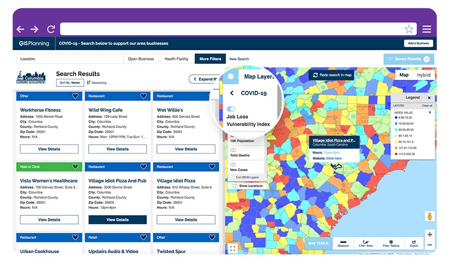
GIS Planning has launched an online tool that enables local businesses across North America to communicate with customers for free in real time.
ZoomBusiness, created in response to the COVID-19 pandemic, is an interactive, mobile-responsive mapping directory for communities that ensures customers can find open restaurants, stores and services in their region at no charge.
Businesses can list themselves for free on their local ZoomBusiness site, hosted by economic development organizations like cities, towns, counties or chambers of commerce. The businesses can provide customized details including websites, modified hours, delivery or curbside pickup options, promotions and gift card stimulus programs.
Residents can search for area businesses by categories, including grocery stores, pharmacies, banks, health facilities, hardware stores, pet stores and automotive shops, among others.
North America deployment
Local ZoomBusiness sites have already been deployed in more than 20 communities across North America during its soft launch, including regions of eastern Pennsylvania;, the City of Columbia, South Carolina; the state of Wyoming (which has listed more than 600 businesses on the directory); and Abbotsford, British Columbia.
“We created ZoomBusiness after realizing that small businesses need new, accurate ways to communicate that they are still open to their customers, given that social distancing requirements, product availability and operating hours are changing by the day,” said Pablo Monzon, managing director and co-founder, GIS Planning. “Our development team has created an intuitive tool to index and map business information across North America in real-time, and we believe it will be an enormous resource for the communities we serve.”
ZoomBusiness is a simple-to-use data tool, powered by Google Maps, using various layers for precise queries. Businesses are prompted to directly enter information on their current status and the content is verified by the organization hosting the GIS tool.
GIS Planning also added free map layers, including a COVID-19 case map updated daily by the New York Times, and a job-loss vulnerability index using recent employment data from Chmura.
Screenshot: GIS Planning
Columbia, South Carolina
The city of Columbia features 180 businesses on ZoomBusiness, helping residents discover delivery and curbside food options. That number is expected to quickly rise to more than 300 as business owners input data. Columbia will continue to promote safe and responsible “Shop Local” practices, Coleman added, in hopes that residents will take advantage of the service and support local businesses.
“Through our work with GIS Planning, we’ve been able to take our list of open restaurants and businesses and integrate it into the available properties map on our website,” said Ryan Coleman, director of the City of Columbia Office of Economic Development. “During this crisis, local businesses need every advantage we can give them, and this is another tool in their arsenal in helping to mitigate the negative impact of COVID-19.”
Abbotsford, British Columbia
The new solution has also made an impact in Canada, including the City of Abbotsford, British Columbia, which is promoting 130 businesses ranging from grocers to auto shops and medical suppliers.
“This is a resource that fills an urgent need. The long-term health and security of our businesses depend, in part, on the decisions we’re making right now,” said Kim O’Sullivan, City of Abbotsford’s economic development coordinator. “ZoomBusiness allows owners to communicate directly with their customers, many of whom would frequent these businesses, even online, if they knew they were able to do so.”
ZoomBusiness clients are given a unique link to their region which is then shared across organizational websites and social media to reach residents.
“Main Street businesses are truly the lifeblood of a community,” said Alissa Sklar, vice president of marketing for GIS Planning. “According to FEMA, up to 40% of small businesses never reopen after a major disaster. With ZoomBusiness, we want to help make sure the local restaurants, retailers and service providers that define local communities are still there to serve area residents when this pandemic is over.”
GIS Planning has made its ZoomBusiness tool free for its existing economic development clients (those using its investment attraction map, ZoomProspector); it is also available to new clients for a nominal fee. Prices are indexed to population size to keep them affordable for all communities. New clients can also be set up and ready to launch the tool within one day.
Following the COVID-19 recovery, data experts at GIS Planning forecast continued use of the directory to promote small and medium-sized businesses across North America.
The Esri User Conference, which usually takes place in San Diego in July, will this year be held virtually.
“As a result of the coronavirus disease 2019 (COVID-19) crisis, we are making the decision to move the 2020 Esri User Conference in San Diego to a virtual format. This is a great disappointment to me personally, as I know it will be for many of you,” Esri CEO Jack Dangermond told those planning to attend in an April 22 e-mail.
The following is an outline of Esri’s current plan, with more information available in the Esri UC FAQs:
The event will take place July 13–15, 2020.
The plenary session, technical workshops and Esri Showcase will be virtual, featuring many demonstrations and live discussions during the conference.
There will be many opportunities for networking, collaboration and real-time interaction with Esri experts and staff.
User presentations and the map gallery will be featured digitally.
A library of recorded sessions and demos will be created and kept available as an ongoing resource.
Registration will be complimentary for all Esri customers who are current on their maintenance or subscription.
“Forty years ago this month, we had our first User Conference in Redlands, California, with only a handful of participants,” Dangermond wrote. “While initially no one was quite sure of what the outcome would be, the event started an ongoing tradition where Esri and our users would come together, share our work, learn and create a community of common interests.
“That first meeting on the Esri campus provided the groundwork for the annual event at which thousands of professionals from every corner of the globe meet one another, share inspiring examples of work and learn from each other’s experiences.
“While we can’t replicate the experience of being together in person, we will do our best to create an amazing event that will continue to move you and our community forward. One of the benefits of going with a virtual format will be that organizations will be able to send an unlimited number of attendees.”
Sand Studio, a mobile device management (MDM) solution provider, is offering AirDroid Business Geofencing, a location-based solution for businesses to monitor and track device location, automate tasks and receive notification alerts in one place.
With geofencing, organizations that have vehicles, personnel or valuable assets in the field can use tracking data and workflows to enhance security and optimize operational efficiency.
Geofencing integrates seamlessly with AirDroid Business’ easy-to-use yet powerful device management solution, enabling IT managers to apply different configurations to existing or newly created device groups at any time.
Adding to the existing location tracking feature, AirDroid Business Geofencing brings new capabilities like geofencing, path tracking, automated workflow, logs, and notification management.
Geofencing: Location-based technology where a customizable virtual fencing zone can be created for devices that are coming in and out of a predefined area on a map. Single devices or groups of devices can be added to multiple profile zones for different scenarios, which provides flexibility and more control over deployed devices.
Path Tracking: Admins can track a device and see its extensive path history. This allows for an in-depth analysis by combining time and location. For instance, admins can track a delivery truck and see if it has deviated from the assigned route, analyze the data, and improve operational efficiency.
Workflow, Logs and Notifications: Workflows work together with geofences. Triggered by a device entering or exiting a geofence, workflow will activate automated tasks such as device locking and factory reset. Working side-by-side with workflow is log management, where point of time, device activity, device status and events can be filtered to spot abnormal activities or insights for improvements.
“With mobile transformation continuing to take place in every industry, more businesses and organizations are deploying mobile devices in the field. However, they are also faced with the challenge of managing these devices,” said Anson Shiong, CEO of Sand Studio. “To help with this transition, AirDroid Business’ focus on remote device management and the new geofencing solution will help businesses maintain security and operational efficiency. These new features are designed to monitor and track remote devices with precision from anywhere in the world.”
Geofencing is beneficial to a range of industries such as medical and health institutions, public agencies who need to track people at risk in situations like the coronavirus outbreak, transportation and logistics companies that need specific details on fleet activity, corporations that disseminate company devices with confidential information, food delivery services and more.
The new tracking capabilities ensure consistent employee productivity levels as well as enhance security by knowing where the employees and devices are while also enabling confidential materials to be remotely wiped from a device when outside of the safety zone.
The USGIF Awards Program annually recognizes the exceptional work of the geospatial intelligence (GEOINT) tradecraft’s brightest minds and organizations pushing the community forward.
Award winners are usually recognized at the annual GEOINT Symposium. This year’s event, scheduled for April 26-29 in Tampa, Florida, was canceled because of the COVID-19 pandemic.
“Unfortunately, you will not see the awardees recognized on the GEOINT Symposium stage this year,” said Kevin Jackson, chair of the USGIF Awards Subcommittee. “So please take a moment to read their accomplishments and join me and the USGIF in congratulating the 2020 USGIF Achievement Awardees and the runners-up.”
Award winners are nominated by their colleagues and selected by the USGIF Awards Subcommittee.
“The 2020 USGIF awardees reflect the importance and the significance of the outstanding work that occurs daily in the GEOINT community,” Jackson said. “You will see how the GEOINT community always rises to the occasion to face head on the world’s toughest problems and this year is no exception.”
Academic
James Martin Center for Nonproliferation Studies, Middlebury Institute
On Dec. 7, 2019, after denuclearization negotiations between the United States and North Korea collapsed, North Korea reversed commitments made in Singapore and resumed engine testing at its Sohae Satellite Launch Center. Using new technological opportunities offered by high-cadence moderate resolution satellite imagery and flexible high-resolution satellite image tasking provided by Planet Labs, analysts at the CNS, through the use of open-source GEOINT, detected and correctly identified preparations for the engine test 39 hours before it occurred. Announcing in advance that North Korea was preparing to violate an international nonproliferation commitment.
Community Support
NGA Expeditionary Operations Office
NGA’s Office of Expeditionary Operations provides deployed personnel and technology to support GEOINT activities of worldwide U.S. military operations, humanitarian assistance and disaster relief efforts, and other national security objectives. The team’s world-class workforce seamlessly enables trusted global GEOINT capabilities today, while developing programs and processes to meet emerging challenges. Robust partnerships with DoD and IC allies fuel innovation and expertise, helping U.S. and foreign partners build programs that anticipate their needs, expanding the GEOINT community and optimizing meaningful consequence across the GEOINT enterprise.
Government
Mark A. Skoog and Loyd R. Hook
Implementing digital terrain solutions for safer aviation has been a career-long goal for Mark Skoog and Loyd Hook. As true innovators and lifelong proponents of using digital terrain data, Skoog and Hook lead the development efforts of NASA’s award-winning Automatic Ground Collision Avoidance System (Auto GCAS), which prevents imminent collisions with the ground. Auto GCAS is the culmination of a decades-long effort to bring geospatial intelligence to aircraft safety. This work involved traveling the world, evaluating myriad digital terrain from Sweden to Hawaii. The team extensively tested the system to ensure against every category of controlled flight into terrain mishaps—and found it would have prevented every one, which resulted in ten lives saved thus far in the USAF operations.
Industry
Lockheed Martin Space GATR Team
Globally-scalable Automated Target Recognition (GATR) is an artificial intelligence system that finds objects of interest in satellite imagery on a worldwide basis. It was developed by a team of scientists and engineers from Lockheed Martin Space who combined state-of-the-art deep learning algorithms with scalable high-performance computing in a cloud-based framework to achieve high-speed global automated target recognition (ATR). Unlike other ATR systems, GATR searches extremely large geographic regions with accuracy and speed. The GATR team, led by Dr. Mark Pritt, includes Tyler Bartelmo, Gary Chern, Dr. Austen Groener, Michael Harner, Andy Lam, Stephen O’Neill, Ryan Soldin, and Steve Wozniak.
Military
RS/GIS CX, The GRiD Team
David Finnegan and the Geospatial Repository & Data Management System (GRiD) program provide the Department of Defense (DoD), intelligence community and geospatial community with a centralized repository for the storage, discovery, and dissemination of critical terrain and 3D data. Prior to the GRiD program, the National System for Geospatial Intelligence (NSG) lacked a centralized mechanism for the storage and discovery of this essential content. Historically, the data was subject to local storage, limiting visibility and resulting in retasking collection assets for previously characterized areas, putting military personnel and equipment at risk. By partnering with the National Geospatial-Intelligence Agency (NGA) and the DoD, the GRiD program is now the community standard and enterprise solution for 3D/elevation data discovery across the NSG.
USGIF, the United States Geospatial Intelligence Foundation, is dedicated to bringing together the many disciplines involved in GEOINT to exchange ideas, share best practices and promote the education and importance of a national geospatial intelligence agenda. For more on the awards program, visit the USGIF website.