Tag: GIS

  • Carlson introduces BRx7 redesigned GNSS receiver

    Carlson introduces BRx7 redesigned GNSS receiver

    Photo: Carlson Software
    Photo: Carlson Software

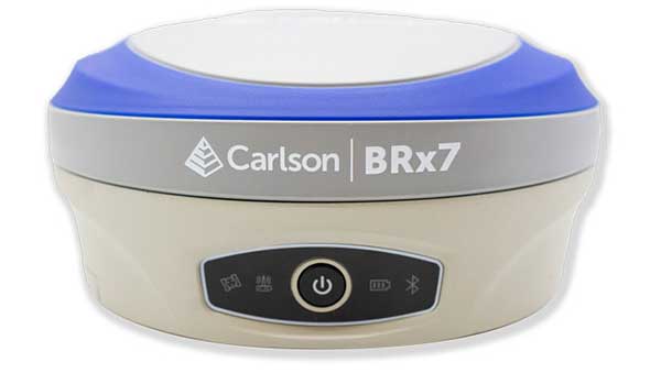
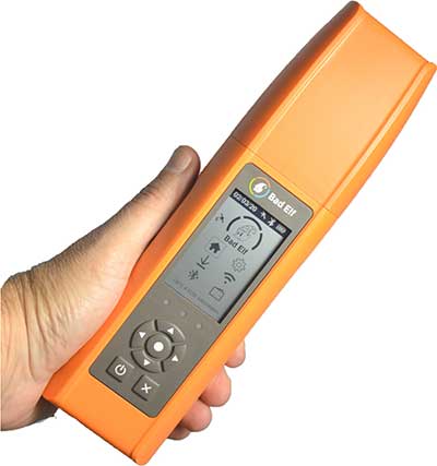
    Carlson Software is now offering its next-generation multi-frequency, multi-GNSS BRx7 smart antenna.

    The BRx7 is a full redesign of Carlson’s flagship GNSS receiver, delivering high-level specifications, performance and value for surveyors, contractors, engineers and GIS professionals.

    Weighing 2.8 pounds with batteries, the BRx7 saves time and increases productivity by accurately compensating for tilt. It comes standard with dual, hot-swappable batteries for 11+ hours of uninterrupted efficiency. The BRx7 provides 800+ channels, 8gb of memory, and is designed with a rugged, compact IP67-rated housing.

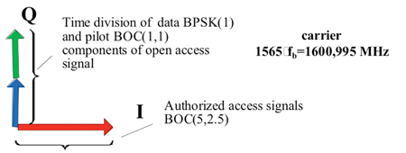
    Best-in-class RTK performance is provided by the Athena GNSS engine, supporting multi-frequency GPS, GLONASS, BeiDou, Galileo, QZSS, IRNSS and Atlas L-band capability. In addition, the BRx7 uses proprietary SureFix technology to provide a high-fidelity quality indicator of the RTK solution, allowing users an extremely high confidence in their current accuracy.

    The BRx7 provides RTK baselines up to 50 km with fast acquisition times when used with Carlson Listen-Listen, as well as UHF, spread spectrum, cellular, Bluetooth and Wi-Fi wireless communication.

    Well-suited to a variety of operating modes, the BRx7 can be deployed as a powerful base with additional access to BeiDou phase 3 satellites in a base-rover setup, or as a lightweight, powerful network rover.

    “The BRx7 represents the next generation of GNSS technology,” said Butch Herter, Carlson’s director of hardware development. “Through this total redesign in partnership with our manufacturer, Hemisphere GNSS, we’ve brought the technology and functionality above the competition while retaining the ease-of-use, durability, and superior support that Carlson is known for.”

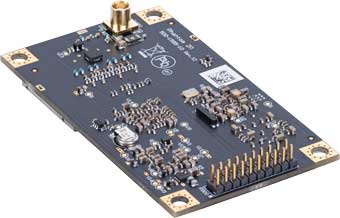
    The smart antenna comes with a dual-band radio module that is capable of both 400 MHz and 900 MHz operation. This allows for the long range capability of the UHF 400 MHz signal plus the ability to switch to the 900 MHz frequency-hopping spread spectrum (FHSS) signal for better performance in noisy radio environments.

    The BRx7 introduces a new INS-based sensor-fusion platform to support enhanced tilted pole measurements for land survey applications. This new design allows for easy calibration, is immune to magnetic interference, and is extremely reliable in virtually any environment.

    “The BRx7 represents the advanced technology, durability, and ease-of-use that our customers have come to expect,” said Bruce Carlson, founder and president of Carlson Software. “By redesigning this system from the ground up, we are offering our customers both unparalleled performance and versatility, but also a value that’s unbeatable in the market today.”

    For more information about the Carlson BRx7, download the BRx7 brochure or contact your local Carlson representative or Carlson dealer at www.carlsonsw.com/where-to-purchase or call Carlson at 606-564-5028.

  • 1Spatial becomes corporate member of DAMA UK, releases software upgrades

    1Spatial becomes corporate member of DAMA UK, releases software upgrades

    Logo: 1Spatial

    1Spatial has released a number of updates, including its membership in the Data Management Association (DAMA) UK and two software updates.

    DAMA UK membership

    1Spatial is now a member of DAMA, a global community of data management professionals organized around local membership-based chapters. The chapters are supported by DAMA International, which maintains the data management body of knowledge and the certified data management professional certification. DAMA UK is a local chapter that aims to nurture a community of data professionals in the U.K. who champion the value of data management.

    1Integrate v2.7

    1Spatial has unveiled 1Integrate v2.7, which the company says ensures compliance of data for use across the enterprise and provides automated data validation, cleaning, transformation and enhancement. It also enables users to access the quality of data to ensure it meets defined specifications and is fit for purpose.

    This release adds support for Esri feature services via a connection to the ArcGIS server, enhanced security features and the ability to define custom task labels. It’s also able to toggle groups of indexes for improved efficiency when configuring data stores, as well as provide simple integration wit lightweight directory access protocol for WEbLogic installations. It features custom task labels, updated platform support and a clearer view of available datastores if FME is not being utilized alongside 1Integrate.

    “We have focused our improvements on data access, with the ability to connect to Esri ArcGIS Server essential as many of our customers are moving to SaaS offerings,” said Sarah Gadd, 1Integrate product manager. “We have also made improvements in usability, with the new custom tasks labels making even the most complex sessions easier to read and maintain. Our platform refresh means we can deliver the latest security enhancements, and by further expanding our datastore support we can offer customers even more options for data validation and enhancement.”

    1Data Gateway v2.1

    1Spatial also has released 1Data Gateway v2.1. According to the company, 1Data Gateway is a web-based portal for spatial data validation, processing and analytics. It provides a simple and controlled way to deliver validation rules, corrections and data enhancement processes for users with no training required and can be deployed on the cloud or on-premise, the company added.

    1Data Gateway (Image: 1Spatial)
    1Data Gateway (Image: 1Spatial)

    The release includes a variety of new features, including the introduction of conformance thresholds which enable the automatic rejection of submissions, giving customers more control over validation of their data. It also includes support for 1Integrate 2.7, user interface and washboarding improvements, support for missing features and attributes, task conformance pass thresholds, improved schema mapping management, media retention policies, more granularity in user permissions and export statistics in CSV format.

    “1Data Gateway is successfully serving large governmental and private agencies, helping them to ensure the quality of incoming data from supply chains is as they would expect,” said Ricardo Cifres, 1Data Gateway product manager. “With this new release we can deliver even more flexibility and security, improving our customer’s data governance processes even further.”

  • Blue Marble releases Global Mapper Mobile v2.1 with advanced GPS support

    Image: Blue Marble
    Image: Blue Marble Geographics

    Blue Marble Geographics has released version 2.1 of its mobile mapping application Global Mapper Mobile, with updates to both the free and Pro versions.

    Global Mapper Mobile is an iOS and Android application for viewing and collecting GIS data. It utilizes the GPS capabilities of mobile devices to provide situational awareness and locational intelligence for remote mapping projects.

    A complement to the desktop version of Global Mapper, the mobile edition can display all of the supported vector, raster, and elevation data formats and offers a powerful and efficient data collection tool. The latest release includes improvements to its vector feature styling, terrain layer support, and layer transparency setting.

    For advanced field mapping functionality, the latest release of the optional Pro version (available for purchase) introduces advanced GPS support. This allows users to connect to external, high-accuracy Bluetooth GPS devices from vendors such as Bad Elf and EOS, among others, directly from Global Mapper Mobile, allowing users to access detailed information including the current satellite constellation, precise location information and the raw NMEA stream.

    “Global Mapper Mobile v2.1 brings exciting new functionality to the application, much of which was highly driven by user requests and feedback,” said Jeffrey Hatzel, senior application specialist at Blue Marble Geographics.

    Blue Marble’s GIS software is used by hundreds of thousands of satisfied customers throughout the world who need affordable, user-friendly, yet powerful GIS solutions. Users come from a wide range of industries including software, oil and gas, mining, civil engineering, surveying, and technology companies, as well as government departments and academic institutions.

    Visit the website to learn more and download Global Mapper Mobile v.2.1.

  • Cesium adds global layer of 3D buildings

    Cesium adds global layer of 3D buildings

    Cesium users now have access to Cesium OSM Buildings, a global base layer of more than 350 million 3D buildings.

    Cesium OSM Buildings expands the suite of Cesium Global Base Layers including worldwide terrain, aerial imagery and streetmaps already available on Cesium ion.

    “As digital twins and urban mapping gain momentum in 3D geospatial, we are excited to offer a global layer of 3D buildings that can be easily visualized, styled and analyzed in an efficient and interoperable manner using 3D Tiles,” said Cesium CEO Patrick Cozzi. “Cesium OSM Buildings will help geospatial developers innovate by giving urban context to 3D applications for a broad range of use cases.”


    Take a tour of Cesium OSM Buildings.


    Cesium OSM Buildings are built for efficient visualization and are streamable to any device thanks to 3D Tiles, the OGC open standard developed by Cesium to stream massive 3D geospatial datasets. Adherence to open standards means the buildings can be used in any compatible viewer, including Cesium’s free open-source offering, CesiumJS.

    Seattle's Space Needle. (Image: Cesium)
    Seattle’s Space Needle. (Image: Cesium)

    “Cesium OSM Buildings will be useful for everyone from builders sharing planned construction projects, to government agencies seeking tools for planning, training, and simulation,” said Kevin Ring, lead developer on the project.

    Cesium OSM Buildings are derived from OpenStreetMap, a community-driven mapping project that welcomes anyone to improve the dataset. Buildings are also regularly updated, firmly clamped to terrain, and are individually selectable and styleable.

    “Thanks to the OpenStreetMap project, most cities contain rich metadata that is useful for on-the-fly styling, like highlighting hospitals in a certain color or filtering buildings by the year they were constructed,” Ring said.

    Cesium OSM Buildings is included in every Cesium ion subscription.

    Cesium is a complete platform that makes the world’s ever-growing collection of real-world 3D data more useful and accessible by enabling the creation of applications that visualize, analyze and share this data – all from your browser.

    Rooted in the aerospace industry, Cesium was built to track satellites orbiting the Earth with sub-millimeter accuracy. Cesium continues to aggressively develop and enhance the platform for a range of customers in government agencies, startups and Fortune 500 companies alike.

  • UP42 partners with Vultus for precision ag solutions

    UP42 partners with Vultus for precision ag solutions

    Photo: UP42
    Photo: UP42

    UP42 has partnered with Vultus, which specializes in precision farming technologies.

    According to UP42, its customers can now use Vultus Fertilization Zoning Maps algorithms to fine-tune crop management — with more agricultural technologies coming soon.

    Founded in 2016 in Lund, Sweden, Vultus AB provides a geospatial infrastructure for precision farming. Vultus analyzes Earth observation satellite data with advanced artificial intelligence algorithms to give farmers insights into the health of crops within small sections of their fields, enabling them to apply fertilizers variably across the field.

    “Growers reduce nitrogen-based fertilizer use by up to one third while increasing yield by three to five percent with the Vultus technology,” said Robert Schmitt, Vultus CEO. “This results in lower operating costs and significantly less environmental harm.”

    Fertilization Zoning Maps — the first in a series of proprietary algorithms Vultus brings to UP42 as a partner — shows farmers which parts of their fields need more or less fertilizer. Fertilization Zoning Maps divide fields into five zones that are classified according to the variable fertilization rate the soil requires, Vultus said.

    By partnering with Vultus, UP42 also brings precision farming technologies to the users of its geospatial developer platform and marketplace for Earth observation data and analytics. With the addition of Vultus technologies, UP42 customers can now pick and choose combinations of data and processing algorithms for their area of interest and retrieve results on a single scalable platform.

    “We’re very happy to announce a new partnership with Vultus, an emerging leader in the agritech industry,” said Sean Wiid, UP42 CEO. “Our partnership is a key step towards providing UP42 users with a simplified way of building precision agriculture solutions. We look forward to launching new capabilities and supporting the agritech industry together.”

  • National Governors Association, Esri release updated COVID-19 map

    Photo: MyImages_Micha/iStock / Getty Images Plus/Getty Images
    Photo: MyImages_Micha/iStock / Getty Images Plus/Getty Images

    The National Governors Association has partnered with Esri to publish a comprehensive update to its interactive COVID-19 State and Territory Action Tracker.

    According to the association, the interactive mapping-based app shows how jurisdictions have taken actions to reopen certain business sectors by issuing statewide orders. It also shows how jurisdictions are undertaking regional-based approaches or implementing statewide orders with authorization for localities to place additional restrictions.

    The map also allows users to explore public health actions governors have taken during the pandemic, including statewide stay-at-home orders, limits on gatherings, state employee travel restrictions, quarantine orders for interstate travel and more.

    The map, which is updated on a daily basis, features data collected from states and territories. The data is based on an evaluation of state executive orders, directives, guidance, legal and non-legal documents, and news sources, the National Governors Association said.

  • Bad Elf GNSS receiver adopts Hemisphere Phantom module

    Bad Elf GNSS receiver adopts Hemisphere Phantom module

    Bad Elf LLC has completed transition of all Bad Elf Flex receivers to the Hemisphere GNSS Phantom OEM module.

    Photo: Bad Elf
    Photo: Bad Elf

    As one of the first partners to incorporate the Phantom, Bad Elf Flex offers significantly enhanced capabilities and further exemplifies the company’s commitment to future-ready GNSS designs.

    “We tested the Phantom OEM modules extensively, and confirmed they deliver the promised power savings and performance improvements when integrated with the Bad Elf Flex,” said Larry Fox, Bad Elf’s vice president of marketing and business development. “Hemisphere’s technology allows us to democratize GNSS through Bad Elf Flex.”

    The new Phantom modules deliver a 30% gain in battery life, superior performance and scalable access to every GNSS constellation and signal, including GPS, Galileo, GLONASS, BeiDou, QZSS, IRNSS, SBAS and Hemisphere’s Atlas L-band, Fox said.

    Photo: Hemisphere GNSS
    Photo: Hemisphere GNSS

    Bad Elf Flex is a scalable-accuracy GNSS receiver with a daily option to choose between L-band and real-time kinematic (RTK). In standard configuration, it achieves 30-60 cm accuracy in real-time for GIS use.

    Consuming a Bad Elf Flex Token unlocks a full RTK workflow for a 24-hour period to deliver 1-cm horizontal accuracy. Bad Elf Flex stores the tokens directly on the receiver, making them available for use anytime and anywhere. Customers requiring high accuracy at all times can purchase the Bad Elf Flex Extreme bundle, with RTK capabilities permanently unlocked, for a one-time upgrade fee.

    Surveyors and their crews now have a scalable-accuracy, survey-grade receiver. GIS managers can focus on flexible field choices for work crews with varying skill levels. Bad Elf Flex falls within most capital expense budgets, allowing businesses to obtain operational and financial efficiencies.

    “Bad Elf saw an opportunity to offer the GIS community a product lineup with better than 3-meter accuracy for under $3,000,” said John Cunningham, Bad Elf’s chief executive officer. “We began three years ago with our 2-meter ($300) and 1-meter ($600) mapping-grade product offerings. Our customers continued asking us to address the 50 cm, 10 cm and 1 cm requirements for their businesses. We worked hard over the past two years to build a platform, Bad Elf Flex ($3,000), that addresses these needs without breaking budgets. We have a solution that works today and provides a foundation to meet future customer requests. We love learning from our customers and look forward to continuing this conversation and extending high-accuracy GNSS for all.”

    “Hemisphere is excited that Bad Elf’s Flex series now features our latest generation GNSS receiver,” said Miles Ware, director of marketing at Hemisphere. “We believe the scalable accuracy option made possible by our high-performance Atlas L-band correction service will be a game-changer in their served markets.”

  • URISA accepting applications for Vanguard Cabinet

    Logo: URISA Vanguard Cabinet

    The Urban and Regional Information Systems Association (URISA) is now accepting applications for its Vanguard Cabinet.

    The Vanguard Cabinet is an advisory board made up of passionate, young geospatial professionals who strive to engage young practitioners, increase their numbers in the organization and better understand the concerns facing these future leaders of the geospatial community. The board consists of members that are 35 years of age or younger.

    The cabinet’s mission is to collaborate with URISA’s board of directors and URISA committees in creating and promoting programs and policies that will benefit young professionals, as well as enhance overall innovation, collaboration, networking and professional development opportunities.

    Cabinet members are selected through an application process, with a review by the URISA Leadership Development Committee. Those who apply must submit a letter of reference from a colleague, supervisor, mentor or instructor; a resumé; and a completed online application form.

    The application process will close on July 20.

  • How aerial imagery helps protect natural resources

    How aerial imagery helps protect natural resources

    Photo: Lake County Forest Preserves
    Photo: Lake County Forest Preserves

    An upcoming GPS World webinar shows how high-definition aerial imagery can help protect and maintain natural resources.

    In Transforming Land and Asset Management with HD Aerial Imagery, four
    mapping experts discuss how Lake County Forest Preserves of Illinois uses HD aerial imagery to manage and track changes.

    The webinar, sponsored by Nearmap, takes place June 25 at 1 p.m. EDT / 10 a.m. PDT / 7 p.m. (1900h) Central European Time. Registration is free.

    Managing and protecting the nearly 31,000 acres of the preserves is no small task, so the ability to see the environment at scale in crystal-clear clarity is a must. Aerial imagery provides an “eye in the sky” to get better context of truth on the ground.

    Lake County Forest Preserves uses Nearmap aerial imagery to:

    • monitor and track change over time with historical and current captures
    • assess and address invasive species growth with high-resolution imagery
    • manage remote work challenges during COVID-19 to locate assets.

    Joining Brett Clark of Nearmap are three experts from Lake County Forest Preserves.

    Nick SpittlemeisterNick Spittlemeister
    GIS Analyst, Planning and Land Preservation Dept.
    Lake County Forest Preserves District (IL)

    Nick Spittlemeister has been with Lake County Forest Preserves since 2016, working to create an enterprise solution that employs web GIS in all facets of the organization. He helped the district secure a license with Nearmap in 2018 and has deployed it across their GIS system, from Desktop software to web applications and native apps. He has been using GIS for more than 15 years and holds a bachelor’s degree in geography from Northern Michigan University.

    Dave CassinDave Cassin
    Manager of Landscape Ecology
    Lake County Forest Preserves District (IL)

    David Cassin’s remote sensing training began in the US Navy (1990-94) where he was trained as an Intelligence Specialist / Air Photo Interpreter, put into practice during Operation Desert Shield / Storm. Post military service, he continued his craft in college with incorporation of ArcGIS. He combined his skillset and his love of nature by getting a degree in Natural Resource Management. Integrating remote sensing skills into landscape scale restoration projects by utilizing historical air photos and land survey data, he is able to determine historic land uses and alterations. Specific to Nearmap, he was able to map populations of Phragmites australis (an invasive species in Illinois) by utilizing the fall 2019 Nearmap imagery remotely during the COVID-19 stay at home order.

    Kevin KleinjanKevin Kleinjan
    Senior Engineer
    Lake County Forest Preserves District (IL)

    Kevin has utilized aerial imagery and geospatial technologies for over 25 years to inform and support planning and infrastructure related decisions. He utilizes Nearmap’s high-resolution imagery with multiple captures throughout a calendar year to analyze and update infrastructure assets quickly and accurately from both the office, and in the field using mobile devices. This enables him to efficiently manage the District’s sign shop, site amenity and heavy equipment crews. He has dual degree in Landscape Architecture and Geography from South Dakota State University and is a Registered Landscape Architect in Illinois and Wisconsin.

    Brett Clark

    Brett Clark
    Senior Account Executive
    Nearmap
    Brett graduated from Brigham Young University with a degree in communications. He was employee #2 for Nearmap, U.S., and focuses primarily on serving the public sector – both state and local. Brett lives in the Indianapolis area with his wife and three daughters.

    Register for the free webinar here.

  • Mapping tool helps LA County residents find food resources

    Mapping tool helps LA County residents find food resources

    Screenshot: FoodFinder
    Screenshot: FoodFinder

    The non-profit 211 LA County and Slingshot Aerospace have unveiled an online mapping tool that allows users to quickly identify and locate more than 2,000 food resources within the county during and after the COVID-19 pandemic.

    211 LA County is a non-profit organization providing the official information and referral source for health and human services in LA County. Slingshot Aerospace is a situational intelligence platform company,

    The customized tool, called 211 LA FoodFinder, is powered by Slingshot Earth and is the biggest and only food map that allows LA residents to search for resources by location and view services specific to seniors, children and others, enabling individuals to find aid near them faster. Resources within the FoodFinder are free, with the exception of those with suggested donations or delivery service fees.

    LA County residents will be able to identify different types of available food resources, such as child nutrition, meal services, groceries/food pantries, senior food needs and government food benefits programs.

    The platform also provides location details, hours of operation and contact information for each of the services. 211 LA County is currently experiencing a tenfold increase in website traffic related to food resources compared to pre-COVID timeframes.

    The organization anticipates the robust application to service nearly 30,000 LA County constituents over the next quarter, many of which may not have prior experience with food assistance.

    “Food resources are the biggest need people are contacting us about since the COVID-19 pandemic hit LA County,” said Maribel Marin, executive director, 211 LA County. “With so many people out of work, the need for food is going to get progressively more intense, but people shouldn’t worry because there are lots of resources and ways to access them. Our custom Slingshot Earth food locator provides our community with a one-stop-shop for food resource information, helping to provide peace of mind to those who need food assistance during this unprecedented time.”

    211 LA County’s customized Slingshot Earth mapping tool aggregates food resources and service data from multiple public and private sources so that individuals have the right information, at the right time, all in one place. The data is verified and updated regularly to ensure that Los Angeles County residents have the most up to date information as guidelines and offerings continue to evolve.

    “This work to help 211 LA County provide critical food service information in our community is so meaningful to us because we are driven by a vision to create a safer, more sustainable world,” said Mel Stricklan, Co-Founder and Chief Strategy Officer, Slingshot Aerospace. “Our business was founded on the idea that information is power, especially in complex situations. The COVID-19 pandemic is uncharted territory for all of us, and we are happy to do our small part in navigating these tough times by providing essential information to those who need it most.”

  • SimActive releases Correlator3D version 8.5

    Version 8.5 of SimActive's Correlator3D mapping software allows users to share and visualize projects in the cloud. (Photo: SimActive)
    Version 8.5 of SimActive’s Correlator3D mapping software allows users to share and visualize projects in the cloud. (Photo: SimActive)

    SimActive has launched version 8.5 of its Correlator3D mapping software. According to the company, this new version users to share and visualize projects in the cloud. More specifically, results can be exported to the cloud directly from the software interface, and shareable links are automatically created for online visualization.

    Version 8.5 also features tools for the calibration and processing of multispectral imagery. Calibrated reflectance panels and sun sensors can be used to produce reflectance maps, with multispectral bands perfectly registered, the company said.

    “Our software attracts a variety of clients, with a wide range of needs,” said Louis Simard, CTO at SimActive. “This new version brings advantages to customers having data exploitation requirements such as online viewing, and to users processing imagery from highly sophisticated sensors.”

    SimActive, founded in 2003 and based in Montreal, Quebec, develops photogrammetry software. Its Correlator3D software, is a patented, end-to-end photogrammetry solution for the generation of high-quality geospatial data from satellite and aerial imagery.

  • Bentley Systems acquires voice-based field automation provider

    Logo: Bentley Systems

    Bentley Systems has acquired NoteVault, a voice-based field automation provider for construction management. This acquisition expands Bentley’s Synchro digital construction environment with mobile field applications to track and manage labor, materials and equipment.

    According to Bentley Systems, these comprehensive offerings further extend the value of digital twins across construction management, enabling projects to combine immersive 4D models of the construction progress with detailed up-to-date reports on resource expenditures.

    NoteVault’s SaaS solution is deployed via mobile devices, offering natural language automated speech-to-text, augmented with automated machine learning, and human transcription to ensure accuracy. Because NoteVault has been engineered specifically for construction site mobile field reporting, it recognizes construction-specific language for accurate transcription, and enables automated translation so non-native English speakers can submit daily reports more easily using their native language.

    With NoteVault on their mobile devices, construction professionals can help synchronize status reporting effortlessly while saving time and money, reducing the risk of contractual disputes, Bentley Systems added.

    “Digital twins continue to transform the way projects are delivered and operated,” said Dustin Parkman, vice president, project delivery, Bentley Systems. “Inherent in every digital twin is a stream of continuously updated data, and for construction, automating the semantic interpretation of field reports can now be one of the richest sources of live project information. With the addition of NoteVault’s market-leading resource tracking capabilities, the Synchro 4D construction environment delivers the most comprehensive construction digital twin solution available. We are excited to continue advancing the scope of construction digital twins.”