Tag: GNSS simulator

  • Expert Advice: Product Testing: Simulation and Beyond

    By Pierre Nemry and Jean-Marie Sleewaegen, Septentrio Satellite Navigation

    Today’s customers ask for high-accuracy positioning everywhere, even in the most demanding environments. The time is long gone that the only requirement for a receiver was to track GPS L1 and L2 signals in open-sky conditions. State-of-the-art receivers operate in increasingly difficult conditions, cope with local radio-frequency interference, survive non-nominal signal transmissions, decode differential corrections from potentially untrusted networks — and more!

    Difficult real-life operating conditions are typically not addressed in textbooks or in the specialized literature, and yet they constitute the real challenge faced by receiver manufacturers. Most modern GNSS receivers will perform equally well in nominal conditions, or when subjected to nominally degraded conditions such as the ones that correspond to standard multipath models. However, the true quality of a GNSS receiver reveals itself in the environment in which it is intended to be used.

    In view of this, a GNSS manufacturer’s testing revolves around three main pillars:
    ◾    identifying the conditions and difficulties encountered in the environment of the intended use,
    ◾    defining the relevant test cases, and
    ◾    maintaining the test-case database for regression testing.

    In developing new receiver functionality, it is important to involve key stakeholders to comprehend the applications in which the feature will be used and the distinctive environment in which the receiver will function. For example, before releasing the precise-point-positioning (PPP) engine for the AsteRx2eL, we conducted a field-test campaign lasting a full month on a ship used for dredging work on the River Thames and in the English Channel. This enabled engineers to capture different types of sea-wave frequency and amplitude, assess multipath and signal artifacts, and characterize PPP correction data-link quality.

    Most importantly, we immersed the team in the end-user environment, on a work boat and not simply in a test setup for that purpose. As another example, in testing our integrated INS/GNSS AsteRxi receiver for locating straddle carriers in a container terminal, we spent months collecting data with the terminal operator. This was necessary to understand the specificities of a port environment, where large metal structures (shore cranes, container reach-stackers, docked ships) significantly impair signal reception.

    Furthermore, the close collaboration between the GNSS specialist, the system integrator, and the terminal owner was essential to confirm everything worked properly as a system. In both examples, in situ testing provide invaluable insight into the operating conditions the receivers have to deal with, much surpassing the possibilities of a standard test on a simulator or during an occasional field trip.

    Once an anomaly or an unusual condition has been identified in the field, the next step is to reproduce it in the lab. This involves a thorough understanding of the root cause of the issue and leveraging the lab environment to reproduce it in the most efficient way. Abnormalities may be purely data-centric or algorithmic, and the best approach to investigate and test them would be software-based. For example, issues with non-compliance to the satellite interface control document or irregularities in the differential correction stream are typically addressed at software level, the input being a log file containing GNSS observables, navigation bits, and differential corrections.

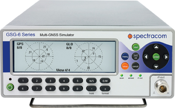
    Other issues are preferably reproduced by simulators, for example those linked to receiver motion, or those associated to a specific constellation status or location-dependent problems. Finally, certain complicated conditions do not lend themselves to being treated by simulation. For example, the diffraction pattern that appears at the entrance of a tunnel is hard to represent using standard simulator scenarios. For these circumstances, being able to record and play back the complete RF environment is fundamental.

    Over the years, GNSS receiver manufacturers inventoried numerous cases they encountered in the field with customers or during their own testing. For each case, once it has been modeled and can be reproduced in the lab, it is essential to keep it current. As software evolves and the development team changes, the danger exists that over time, the modifications addressing a dysfunctional situation get lost, and the same problem is reintroduced. This is especially the case for conditions that do not occur frequently, or do not happen in a systematic way. Good examples are the GLONASS frequency changes, which arise in an unpredictable way, making it very difficult for the receiver designer to properly anticipate. This stresses the importance of regression testing. It is not enough to model all intricate circumstances for simulation, or to store field-recorded RF samples to replay later. It is essential that the conditions of all previously encountered incidents be recreated and regularly tested in an automated way, to maintain and guarantee product integrity.

    The coverage of an automated regression test system must range from the simplest sanity check of the reply-to-user commands to the complete characterization of the positioning performance, tracking noise, acquisition sensitivity, or interference rejection. Every night in our test system, positioning algorithms including all recent changes are fed with thousands of hours of GNSS data, and their output compared to expected results to flag any degradation. Next to the algorithmic tests, hardware-in-the-loop tests are executed on a continuous basis using live signals, constellation simulators, and RF replay systems, with the signals being split and injected in parallel into all our receiver models. Such a fully automated test system ensures that any regression is found in a timely manner, while the developer is concentrated on new designs, and that a recurring problem can be spotted immediately. The test-case database is a valuable asset and an essential piece of a GNSS company’s intellectual property. It evolves continuously as new challenges get detected or come to the attention of a caring customer-support team. Developing and maintaining this database and all the associated automated tests is a cornerstone of GNSS testing.

  • ESA Telecom and Navigation Vehicle Ready for Test Driving

    The radio spectrum is about to get even busier, as Europe’s Galileo satnav system starts services, at the same time the European Space Agency (ESA) tests novel satellite-based telecommunication services. Supporting these developments from the ground, ESA’s new custom-built Telecommunications and Navigation Testbed Vehicle will measure the resulting signals from all over Europe.

    Adapted from a Mercedes Benz Sprinter van, this unique measurement vehicle has been delivered to ESTEC by Austria’s Joanneum Research institute. “This is a dual-purpose vehicle, suitable for both telecommunications and navigation system testing,” explained Simon Johns of ESA’s Radionavigation Systems and Techniques Section.

    “For navigation, we have the Galileo constellation coming on stream, as well as the stepping up of ESA’s GNSS Evolution programme — designing what comes next after Galileo’s first generation.”

    The four wheel-drive vehicle can host a three-person team, and is crammed with dedicated navigation and telecommunication monitoring equipment.

    Testbed vehicle screen.
    Testbed vehicle screen.

    “One of the main goals driving the design was to have an ‘easy to adapt’ test platform suitable to set up test campaigns for different mobile satellite systems and standards that would require different types of antennas and specific receiver/transmit equipment,” explained Olivier Smeyers of ESA’s Communication-TT&C Systems and Techniques Section.

    “On the telecommunications side, there is a continuous effort to enhance current and create new mobile satellite-based broadcast and interactive services via the evolution of current systems or developing new standards,” Smeyers said. “Testing in the field is an essential element for validating and eventually establishing evolved or new standards. The vehicle has built-in multimedia equipment, including storage and control computers, multimedia gateway, passenger LCD screens, cameras and microphones, to serve this purpose.”

    The vehicle features include two removable roof plates to mount specialized antennas (one currently hosts the antenna of a Broadband Global Area Network satellite terminal for Internet connectivity and multimedia and data streaming), an 8-meter-high telescopic mast capable of carrying 25 kilograms, a rubidium atomic clock synchronized to GPS time with nanosecond accuracy, a high-end spectrum analyzer and oscilloscope for signal measurements, and mobile temperature sensors to monitor the rack equipment.

    A fish-eye video camera incorporating onscreen GPS timing and positioning performs continuous recording of its surroundings — to throw light on high buildings, trees, or other factors that might affect results.

    Internal and external generators yield up to 5 kilowatts to keep everything running — sufficient power to supply two typical European households.

    “The challenge was to fit in all the equipment and provide the necessary power and air conditioning, while still weighing less than 3.5 tonnes,” said Thomas Prechtl of Joanneum Research. “Exceeding this weight would have meant drivers would have needed a special license, and potentially limited its operations in some European nations.”

  • Aeroflex Adds Capability to Simulate WAAS LPV Approaches

    Aeroflex Incorporated, a wholly owned subsidiary of Aeroflex Holding Corp., has announced its capability to simulate WAAS (Wide Area Augmentation System) LPV (Localizer Performance with Vertical Guidance) approaches by adding this new feature to their GPSG-1000 Portable GPS Simulator.

    Aeroflex has developed the capability of simulating WAAS LPV approaches to expedite and validate the installation of WAAS-enabled navigation systems in aircraft. The GPSG-1000 offers the following features to installers of these systems:

    • Ability to perform structured, repeatable dynamic motion tests (actual flight) of a WAAS/LPV installation,
    • Ability to check and validate the sensitivity and dynamic range of an airborne GPS receiver, either statically or while in motion,
    • Reduce aircraft down time and flight demonstration time required by FAA,
    • Additional support data for documenting proper FAA processes of WAAS/LPV system upgrades or installs without leaving the hangar.

    New orders for the GPSG-1000 are ready for immediate delivery. For existing GPSG-1000 customers, a no-charge software upgrade will be available by mid-April 2013.

    The FAA created the WAAS program in 1992 to provide the necessary integrity to utilize GPS signals for precision approach. The WAAS consists of a network of precisely surveyed wide area reference stations (WRS). These reference stations monitor GPS satellites to determine errors in the GPS satellite signal. Each reference station relays the information about the GPS satellites to the WAAS wide area master stations (WMS). The master station then develops corrections to the GPS position information and provides timely notification of unreliable GPS data. These corrections are sent to ground uplink stations (GUS) where they are transmitted in the form of a WAAS correction message to a Geostationary Earth Orbit (GEO) satellite. The WAAS signal is then broadcast to users on the same frequency as GPS. This WAAS corrected signal provides three-dimensional guidance to aircraft.

  • Evaluation Kit by NVS Tecnologies

    2ff2ba0051687eef5ca0459cf942940c_XL
    Photo: NVS Technologies

    Evaluation Kit NV08C-EVK-CSM by NVS Technologies is a set of instruments for a developer of systems based on NVS Technologies’ NV08C-CSM module. Use of EVK-CSM is a convenient way to learn functionality of NV08C-CSM and begin system design.

    The EVK-CSM may be used in navigation systems to obtain the current position (latitude, longitude and elevation), velocity vector, and time GNSS signals including GPS, GLONASS, Galileo, Compass, and SBAS in any location on Earth and at any time. The EVK-CSM is a flexible tool that allows users to evaluate various modes of operation of the NV08C-CSM and to override a default configuration and connection diagram with jumpers.

    Connectors and jumpers on EVK-CSM PCB provide simple monitoring of intermediate signals and parameters (digital IOs state, power supply voltages, and currents on individual supply inputs).

  • Navigation Test Supplier IFEN Establishes U.S. Company

    IFEN GmbH, based outside of Munich, Germany, has established IFEN Inc. in the United States. The new U.S. company will address the needs of the American market for GNSS test equipment, IFEN said.

    “IFEN Inc., located in Corona, California, will greatly facilitate order placement, delivery and support for U.S. customers,” said Günter Heinrichs, head of Customer Applications and Business Development, of IFEN GmbH. “We look forward to addressing the needs of this market.”

    IFEN has appointed of Mark Wilson vice president of sales at IFEN Inc. Wilson has more than 20 years of experience in the GNSS market. “I am very excited to join the IFEN team. They have extensive experience in all aspects of GNSS and I am looking forward to offering this expertise and the excellent IFEN products to the American Market,” Wilson said. “Our exceptional products offer unrivaled flexibility and capability, at realistic prices providing huge advantages to our customers.”

    IFEN has more than 15 years of experience in GNSS and offers a range of GNSS test equipment, including simulators capable of simulating all GNSS constellations and frequencies and a multi-GNSS software receiver.

  • Spectracom Simulators Add Channels, Signals

    Spectracom announces its ability to simulate up to 64 RF channels in four frequency bands for testing the integration of most advanced GNSS receivers.

    The GSG series of GNSS simulators are designed to offer as much capability as needed by developers, integrators, and manufacturers of applications for global satellite navigation. “We understand the needs for simulating GPS and GNSS signals varies as much as the applications themselves,” said Spectracom CTO John Fischer. “Now the diversity of GNSS signals enables a new generation of receivers requiring a new set of test tools. We designed our simulators to grow along with the GNSS eco-system while maintaining the affordability and ease-of-use that has been our hallmark.”

    Spectracom offers two fully configurable and upgradeable platforms. For common single frequency applications, the GSG-5 series simulates up to 16 GPS satellites in the L1 band. Users can start with a single-channel RF generator and upgrade their unit in the field when their needs change. For more advanced applications, the GSG-6 series offers up to 64 channels in four different frequency bands simultaneously. Current firmware generates GPS and GLONASS satellites in L1, L2, L2C, and L5. Customers will receive firmware updates when they need to simulate Galileo and Beidou satellites in the E1/B1, E5/B2, E6/B3 bands.

    In addition to generating satellite signals, these GPS and GNSS simulators include other advanced capability in every unit such as simulating satellite-based augmentation systems (SBAS), dynamic motion characteristics (trajectories), multipath, white noise, and interference. Tests can be performed anywhere, anytime, from the convenience of the test bench, Spectracom said.

    “Comprehensive testing and validation of high-reliability positioning, navigation and timing applications has been a natural extension of our rich heritage in delivering precision time and frequency products and systems,” said Spectracom CEO Lisa Withers. “As we continue to expand our GNSS signal management offerings, we are excited to introduce synchronization, simulation and test  solutions that are geared to be readily adaptable to our customers’ unique applications.”

  • Spectracom Simulator Compatible with China’s Beidou System

    Spectracom has announced its upgrade capability to China’s global navigation satellite system, Beidou. The Spectracom GSG Series 5 and Series 6 GNSS signal simulators, released in 2012, are designed to be field upgradeable to simulate current and future GNSS constellations. GSG simulators are capable of outputting the frequencies, modulations and data formats of anticipated GNSS systems. The January release of the Beidou ICD specification has confirmed that Spectracom GPS/GNSS simulators will be able to emulate these satellite signals with a simple field-upgradeable firmware update.

    “In anticipation of the deployment of these new, major GNSS systems, Spectracom ensures that every GSG simulator that leaves the factory is tested for compliance with all the signal frequency and modulation specifications as defined in their ICDs. Customers who have purchased our Series 5 or 6 simulators since June 2012 have this upgrade capability,” Spectracom CTO John Fischer said.

    Spectracom_GSG-62_W
    Spectracom GSG-6 series simulator. Photo: Spectrum

    The Series 5 single frequency simulator is fully capable of the all the signals in the L1 (GPS and GLONASS) / E1 (Galileo) / B1 (Beidou) band, including all the GLONASS FDMA satellites.

    The Series 6 multi-frequency simulator is fully capable of all four bands of all the systems: L1 / E1 / B1; L2 / L2C; L5 /E5 /B2; and E6 / B3.

    Fischer added, “As the need for new signals arise, firmware upgrades will be available. This ensures our customer’s investment is protected. Galileo signals will be available this year and Beidou will be available next year.”

  • Spirent Technical Interchange Features Hands-on Demonstrations

    Next month Spirent is hosting a meeting with hands-on training sessions on GNSS simulation equipment led by Spirent engineers. The 2013 Spirent Federal 2013 GNSS Technical Interchange Meeting will be held March 19-21 at the DoubleTree Hotel Anaheim-Orange County, in Orange, California.

    March 19 and 20 are for general participation. The third day, March 21, features FOUO (For Official Use Only) sessions for U.S. citizens only.

    Topics covered include:

    • SVN49 anomaly simulation
    • Utilizing Remote Control and Motion
    • Advanced Modeling and Simulation Techniques
    • Differential GPS and Augmentation Systems
    • Multi-GNSS constellation testing
    • Integrated GPS/inertial testing (FOUO Session)
    • M-code simulation (FOUO Session)
    • CRPA testing (FOUO Session)

    View the tentative schedule. (PDF)

    The registration rate of $125 covers all meals and parking for three days.

  • Symmetricom Enhances SSU 2000 Platform with GLONASS

    Symmetricom, Inc. today announced two new capabilities for its SSU 2000 Synchronization Supply Unit: a GLONASS timing reference that uses signals from the satellite navigation system operated by the Russian Aerospace Defense Forces, and Synchronous Ethernet (SyncE), an ITU-T synchronization standard that delivers frequency synchronization over the Ethernet physical layer.

    This enhanced version of the SSU 2000 will be the first in a series of forthcoming Symmetricom products that include GLONASS capabilities.

    Available as an integrated card for the Symmetricom SSU 2000, the GLONASS referencing feature will allow customers to support both GPS and GLONASS simultaneously, providing added protection should signals from one navigation system become unavailable. GPS has long served as the primary reference signal for timing and synchronization in telecommunications and other networks. Operators in some regions prefer to use the GLONASS system, either as the primary time reference or in conjunction with GPS signals. Symmetricom has enhanced the SSU 2000 satellite receiver functionality to meet this demand.

    “GLONASS signals have become an important primary reference for timing and synchronization systems,” said Laura Finkelstein, vice president of product management for Symmetricom. “The SSU 2000 is well-established as the synchronization platform for communication service providers globally. The integrated capability to simultaneously support both GPS and GLONASS provides our customers another way to improve the reliability of their network.”

    Timing and synchronization are a focal point technology in Ethernet and mobile carrier networks today. Synchronous Ethernet allows frequency signals to transfer at the physical layer over Ethernet, helping improve network reliability by offering synchronization services to Carrier Ethernet networks. Using SyncE to complement IEEE 1588 Precision Time Protocol (PTP) can enhance PTP services being delivered to mobile base stations deployed in radio access networks. The new SSU 2000 capability puts SyncE and PTP on the same output port, thus providing an ideal synchronization solution for the evolution of mobile networks as they extend coverage and increase capacity.

    Designed in a NEBS-compliant package, the SSU 2000 integrates intelligent functional modules into a flexible, fully redundant system. This enables telecom network operators to seamlessly satisfy current and future requirements for generating and distributing superior synchronization signals for advanced network services.

    The SSU 2000 has been deployed in more than 125 countries as a timing and synchronization distribution system for communications service providers.

  • LabSat 2 Customers Offered Free BeiDou Upgrade

    LabSat 2 now has the ability to record and replay satellite signals from the rapidly expanding Chinese navigation system, BeiDou. LabSat 2 users can now record and replay any combination of two channels from the three available constellations, GPS, GLONASS, and Beidou.

    Existing LabSat 2 users can  download the latest firmware (v2.0.0) and PC software (v2.6.14) to add this functionality with no cost.

    There is a growing trend to include multi-constellation capability into new satellite navigation receivers, giving the end user better coverage in urban canyons, and overall improved positional accuracy, LabSat said.

    There are now 14 operational Beidou satellites, and we have recorded a number of different files from Europe and China containing between 6 and 8 satellites. These scenarios are now included on the hard disk which is shipped with a LabSat 2, which can also be shipped out to existing customers on request.

    The new firmware and software is now available from the Support section of the LabSat website. Follow the upgrade firmware instructions in the manual to upgrade your LabSat 2. For more information contact our LabSat Product Manager, Mark Sampson, [email protected].

  • Spirent Announces Support for BeiDou-2 Testing

    Test solutions company Spirent Communications plc today announced the availability of test systems with support for China’s BeiDou Navigation Satellite System in addition to GPS, GLONASS and Galileo.

    Spirent started shipping BeiDou-ready test systems to customers in 2012. The solution will now be upgraded to full-BeiDou capability using the information from the recently released first full issue of the BeiDou-2 Signal-In-Space Interface Control Document (ICD).

    “Spirent has successfully demonstrated BeiDou-2 in simulation systems at its offices in Beijing, China,” said Stuart Smith, product manager for Spirent’s positioning and navigation group. “Prior to the ICD release we used recorded navigation data to enable our systems to drive a full BeiDou receiver and qualify the implementation. With the release of ICD information, navigation data is generated automatically, as with the other constellations that the system simulates.”

    Spirent’s BeiDou-2 system includes testing for GPS, GLONASS and Galileo, as well as IRNSS, QZSS and SBAS along with options such as interference generation, MEMS sensor simulation and systems targeted at transport segments.

    Background on BeiDou. The BeiDou navigation system, sometimes known as Compass, is a project by China that is being deployed in three phases. BeiDou-2 (the second phase) supports regional operation from a network of geostationary, medium earth orbit and inclined orbit satellites. BeiDou-2 adds to the benefits from “Multi-GNSS” where increased accuracy, availability and integrity are possible from using separate, but interoperable GNSS systems.

    As with any other GNSS, systems using BeiDou require testing. As well as testing the BeiDou stand-alone operation, Spirent’s systems enable testing of interoperability and co-existence testing with other navigation systems and sensors.

  • GPS Satellite Simulator

    CAST Navigation of Tewksbury, Massachusetts introduced its SGX GPS Satellite Simulator. With its compact size — 7 × 11× 3 inches — and weighing in at just over 4 pounds, the SGX is CAST’s newest and smallest fully capable simulator to date.
    The new SGX replaces the CAST-SIMCOM Simulator which was a 17-inch, 50-pound simulator. The SGX lightweight portability operates on AC or battery power, features 16 channels of L1 C/A and P codes, and is extremely accurate and repeatable, according to the company.
    Features include touch screen, individual satellite power control, and start and stop scenarios with a touch of a button.
    The CAST-SGX is portable, affordable, lightweight and utilizes CAST long standing proven technology.
    CAST has been in the GPS simulation and support business for more than 25 years, designing, developing, manufacturing, and integrating innovative GPS/INS simulators and associated equipment for government, military, prime vendor, and consumer markets.

    CONTACT INFO

    Company: CAST Navigation
    Country: United States (USA)
    Email: [email protected]
    URL: http://www.castnav.com